
Station PO NANL - Nain, NL, CA
Network: PO - Portable Observatories for Lithospheric Analysis and Research Investigating Seis
Nearby stations (2 deg radius)
| Station | Name | (Lat, Lon) | Start / End | Elevation |
| NANL | Nain, NL, CA | (56.54, -61.69) | 2011-07-24 / 2599-12-31 | 34 m |
| Crust2 Type: | C2,continental shelf, 1 km seds. |
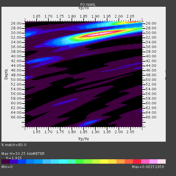
| Thickness Estimate: | 30 km |
| Thickness StdDev: | 1.6 km |
| Vp/Vs Estimate: | 1.91 |
| Vp/Vs StdDev: | 0.05 |
| Vs Estimate: | 3.258 km/s |
| Poisson's Ratio: | 0.31 |
| Peak Value: | 0.06 |
| Assumed Vp: | 6.24 km/s |
| Ps Weight: | 0.33333334 |
| PpPs Weight: | 0.33333334 |
| PsPs Weight: | 0.33333328 |
| Residual Complexity: | 0.387 |
| Nearby stations H: | +- |
| (2.0 deg) Vp/Vs: | +- |
1 with match > 90% ( 7.6923075 %) and 4 with match > 80% ( 30.76923 %) out of 13.
Download stack as xyz text file.
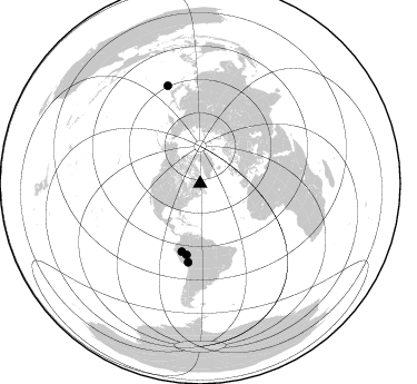
Azimuth Distribution of Events:
Prior Results for this Station
| Study | Thickness | Vp/Vs | Vp | Vs | Poissons Ratio | Extra |
| EARS | 30 km | 1.91 | 6.24 km/s | 3.258 km/s | 0.31 | |
| Crust2.0 | 30 km | 1.80 | 6.24 km/s | 3.467 km/s | 0.28 | C2,continental shelf, 1 km seds. |
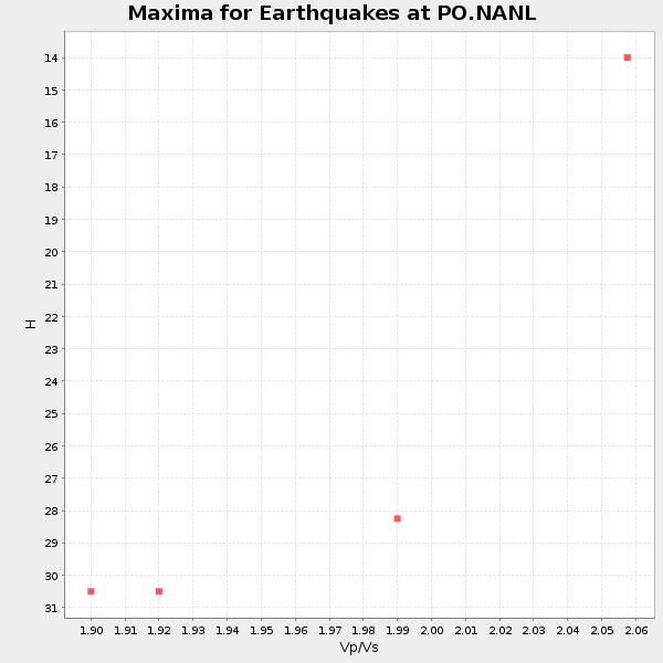
| Global Maxima | 30 km | 1.91 | 6.24 km/s | 3.258 km/s | 0.31 | amp=0.06351956 |
| Local Maxima 1 | 25 km | 2.07 | 6.24 km/s | 3.022 km/s | 0.35 | amp=0.039029475 |
| Local Maxima 2 | 32 km | 1.85 | 6.24 km/s | 3.368 km/s | 0.29 | amp=0.01854626 |
| Local Maxima 3 | 28 km | 2.10 | 6.24 km/s | 2.975 km/s | 0.35 | amp=0.0130249 |
| Local Maxima 4 | 31 km | 1.60 | 6.24 km/s | 3.9 km/s | 0.18 | amp=0.011378319 |
| Predicted Arrivals for vertical incidence (zero ray parameter) | |
| Ps | 4.44 SECOND |
| PpPs | 14.13 SECOND |
| PsPs/PpSs | 18.57 SECOND |
Events Processed for this Station
Download zip of receiver functions as SAC
Plot maxima for each earthquake.
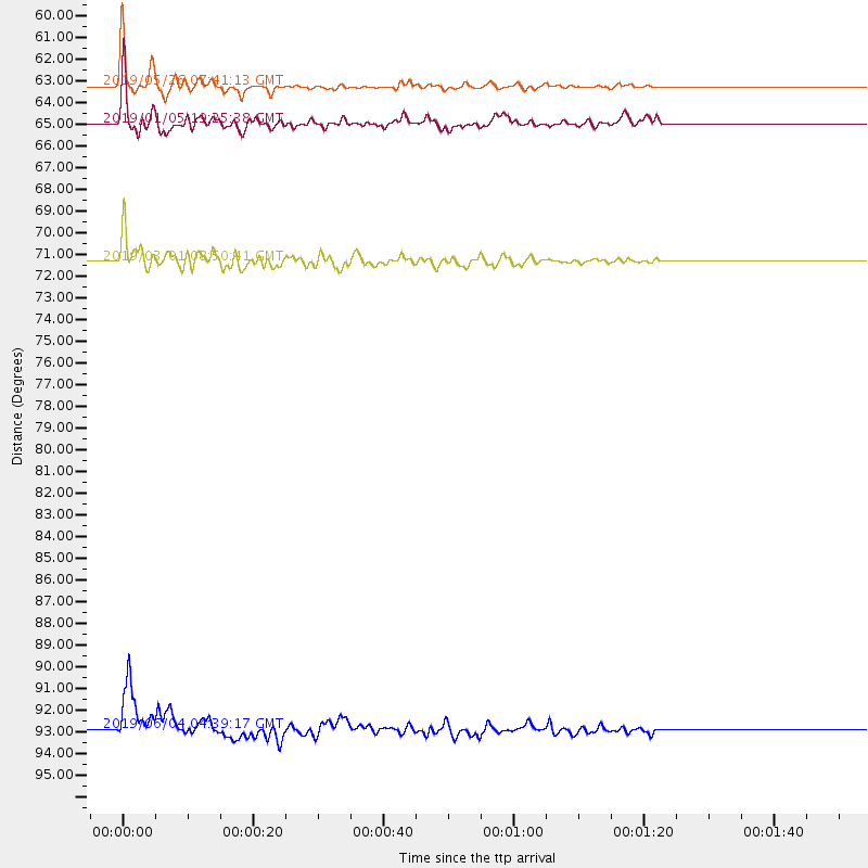
Events Used in the Stack
(4 events)| Radial Match | Distance | Baz | FERegion | Time | Lat/Lon | Depth | Magnitude |
| 97.94343 | 63.2 deg | 195.203 deg | Northern Peru | 2019/05/26 07:41:13 GMT | (-5.9, -75.3) | 105 km | 7.5 Mi |
| 89.28521 | 65.0 deg | 190.812 deg | Western Brazil | 2019/01/05 19:25:38 GMT | (-8.1, -71.6) | 575 km | 6.8 Mww |
| 84.54447 | 92.9 deg | 341.707 deg | Southeast Of Honshu, Japan | 2019/06/04 04:39:17 GMT | (29.1, 139.3) | 430 km | 6.3 Mww |
| 80.79983 | 71.3 deg | 188.623 deg | Central Peru | 2019/03/01 08:50:41 GMT | (-14.7, -70.1) | 257 km | 7.0 mww |
Losers
(9 events)| Radial Match | Distance | Baz | FERegion | Time | Lat/Lon | Depth | Magnitude | Reason |
| 89.44993 | 67.9 deg | 332.736 deg | East Of Kuril Islands | 2019/03/28 22:06:49 GMT | (50.5, 160.0) | 9.0 km | 6.2 Mww | |
| 77.06213 | 60.4 deg | 202.124 deg | Near Coast Of Ecuador | 2019/03/31 07:04:04 GMT | (-2.0, -80.8) | 19 km | 6.2 Mww | |
| 71.810524 | 60.4 deg | 66.274 deg | Turkey | 2019/03/20 06:34:28 GMT | (37.4, 29.6) | 10 km | 5.7 Mww | |
| 69.55833 | 48.2 deg | 215.251 deg | Near Coast Of Nicaragua | 2019/05/16 16:22:16 GMT | (12.6, -87.9) | 62 km | 5.9 Mww | |
| 68.70544 | 74.2 deg | 184.16 deg | Central Bolivia | 2019/03/15 05:03:50 GMT | (-17.9, -65.9) | 358 km | 6.3 Mww | |
| 67.08559 | 79.0 deg | 338.633 deg | Off Coast Of Hokkaido, Japan | 2019/03/02 03:22:52 GMT | (41.9, 146.9) | 10 km | 6.0 Mww | |
| 65.028244 | 86.7 deg | 188.443 deg | Near Coast Of Central Chile | 2019/01/20 01:32:51 GMT | (-30.1, -71.4) | 53 km | 6.7 mww | |
| 62.3518 | 60.9 deg | 197.387 deg | Northern Peru | 2019/01/18 21:27:01 GMT | (-3.3, -76.9) | 103 km | 5.7 Mww | |
| 35.916954 | 71.7 deg | 127.043 deg | North Of Ascension Island | 2019/05/06 13:23:08 GMT | (-3.2, -12.3) | 10 km | 5.4 Mww |

