
Station PO NWRL - North West River, NL, CA
Network: PO - Portable Observatories for Lithospheric Analysis and Research Investigating Seis
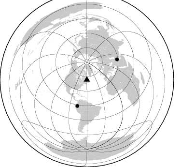
Nearby stations (2 deg radius)
| Station | Name | (Lat, Lon) | Start / End | Elevation |
| NWRL | North West River, NL, CA | (53.53, -60.14) | 2011-07-21 / 2599-12-31 | 6.0 m |
| Crust2 Type: | H1,early/mid Proter., no seds. |
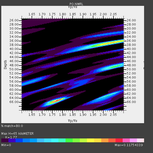
| Thickness Estimate: | 65 km |
| Thickness StdDev: | 18 km |
| Vp/Vs Estimate: | 1.77 |
| Vp/Vs StdDev: | 0.06 |
| Vs Estimate: | 3.734 km/s |
| Poisson's Ratio: | 0.27 |
| Peak Value: | 0.12 |
| Assumed Vp: | 6.61 km/s |
| Ps Weight: | 0.33333334 |
| PpPs Weight: | 0.33333334 |
| PsPs Weight: | 0.33333328 |
| Residual Complexity: | 0.852 |
| Nearby stations H: | +- |
| (2.0 deg) Vp/Vs: | +- |
0 with match > 90% ( 0.0 %) and 2 with match > 80% ( 12.5 %) out of 16.
Download stack as xyz text file.
Azimuth Distribution of Events:
Prior Results for this Station
| Study | Thickness | Vp/Vs | Vp | Vs | Poissons Ratio | Extra |
| EARS | 65 km | 1.77 | 6.61 km/s | 3.734 km/s | 0.27 | |
| Crust2.0 | 40 km | 1.77 | 6.61 km/s | 3.725 km/s | 0.27 | H1,early/mid Proter., no seds. |
| Global Maxima | 65 km | 1.77 | 6.61 km/s | 3.734 km/s | 0.27 | amp=0.11754339 |
| Local Maxima 1 | 37 km | 2.04 | 6.61 km/s | 3.244 km/s | 0.34 | amp=0.08360088 |
| Local Maxima 2 | 48 km | 2.07 | 6.61 km/s | 3.201 km/s | 0.35 | amp=0.055830557 |
| Local Maxima 3 | 63 km | 2.02 | 6.61 km/s | 3.276 km/s | 0.34 | amp=0.05449865 |
| Local Maxima 4 | 58 km | 1.75 | 6.61 km/s | 3.772 km/s | 0.26 | amp=0.025713934 |
| Predicted Arrivals for vertical incidence (zero ray parameter) | |
| Ps | 7.57 SECOND |
| PpPs | 27.24 SECOND |
| PsPs/PpSs | 34.81 SECOND |
Events Processed for this Station
Download zip of receiver functions as SAC
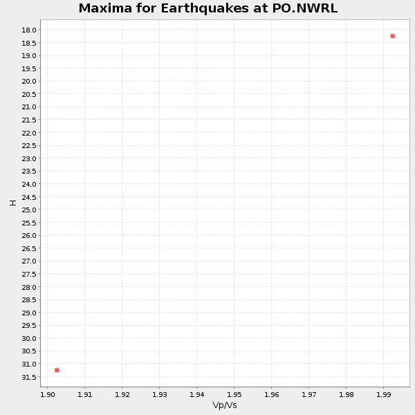
Plot maxima for each earthquake.
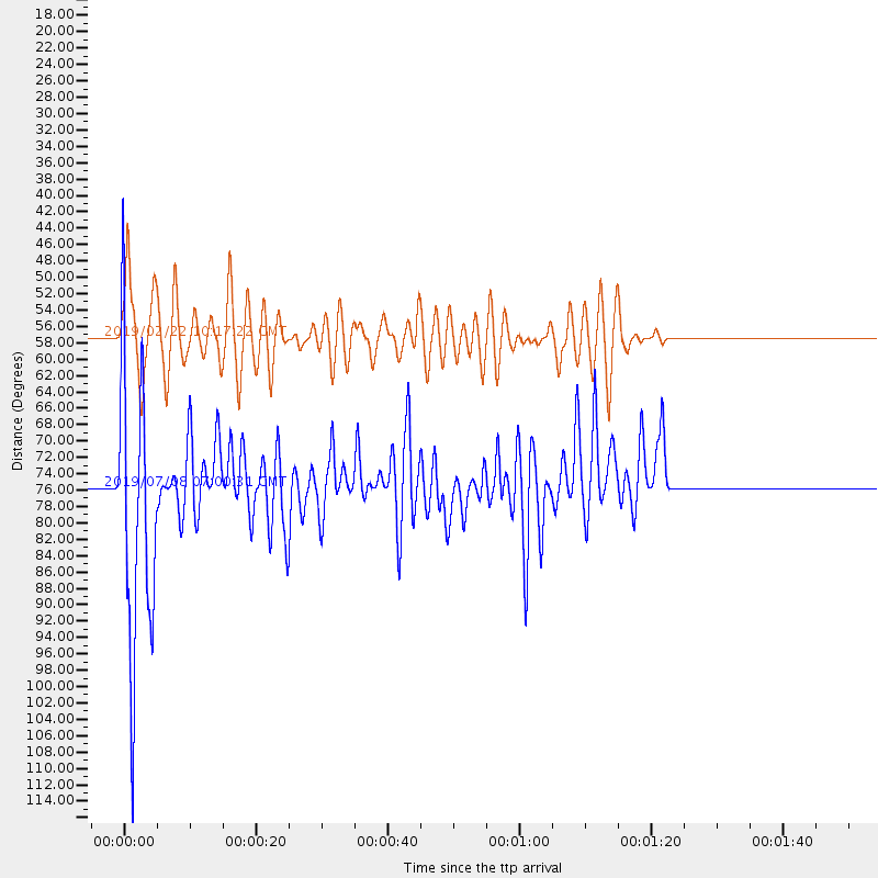
Events Used in the Stack
(2 events)| Radial Match | Distance | Baz | FERegion | Time | Lat/Lon | Depth | Magnitude |
| 83.619095 | 75.6 deg | 55.897 deg | Western Iran | 2019/07/08 07:00:31 GMT | (31.8, 49.5) | 10 km | 5.7 mb |
| 83.4124 | 57.3 deg | 200.172 deg | Peru-Ecuador Border Region | 2019/02/22 10:17:22 GMT | (-2.2, -77.0) | 132 km | 7.5 mww |
Losers
(14 events)| Radial Match | Distance | Baz | FERegion | Time | Lat/Lon | Depth | Magnitude | Reason |
| 78.65099 | 60.6 deg | 197.376 deg | Northern Peru | 2019/05/26 07:41:13 GMT | (-5.9, -75.3) | 105 km | 7.5 Mi | |
| 76.190056 | 57.9 deg | 204.591 deg | Near Coast Of Ecuador | 2019/03/31 07:04:04 GMT | (-2.0, -80.8) | 19 km | 6.2 Mww | |
| 69.04418 | 70.3 deg | 195.39 deg | Near Coast Of Peru | 2019/05/08 13:47:18 GMT | (-15.8, -75.2) | 10 km | 5.8 Mww | |
| 65.431335 | 71.3 deg | 185.782 deg | Central Bolivia | 2019/03/15 05:03:50 GMT | (-17.9, -65.9) | 358 km | 6.3 Mww | |
| 62.371265 | 83.8 deg | 189.82 deg | Near Coast Of Central Chile | 2019/01/20 01:32:51 GMT | (-30.1, -71.4) | 53 km | 6.7 mww | |
| 61.015545 | 66.6 deg | 195.141 deg | Central Peru | 2019/02/14 14:33:16 GMT | (-12.2, -74.3) | 10 km | 5.4 Mww | |
| 60.573593 | 78.2 deg | 189.274 deg | Near Coast Of Northern Chile | 2019/03/28 15:05:32 GMT | (-24.5, -70.1) | 59 km | 5.4 Mww | |
| 60.37167 | 62.2 deg | 192.817 deg | Western Brazil | 2019/01/05 19:25:38 GMT | (-8.1, -71.6) | 575 km | 6.8 Mww | |
| 57.768414 | 55.9 deg | 210.838 deg | Off Coast Of Ecuador | 2019/04/05 18:46:42 GMT | (1.5, -85.3) | 10 km | 5.8 Mww | |
| 56.197968 | 43.3 deg | 269.969 deg | Central California | 2019/07/06 03:47:53 GMT | (35.9, -117.7) | 3.4 km | 5.4 Mww | |
| 55.15484 | 80.8 deg | 38.145 deg | Hindu Kush Region, Afghanistan | 2019/02/02 12:04:34 GMT | (36.5, 70.7) | 211 km | 5.6 Mww | |
| 48.390053 | 68.5 deg | 190.391 deg | Central Peru | 2019/03/01 08:50:41 GMT | (-14.7, -70.1) | 257 km | 7.0 mww | |
| 47.621006 | 60.8 deg | 65.779 deg | Turkey | 2019/03/20 06:34:28 GMT | (37.4, 29.6) | 10 km | 5.7 Mww | |
| 34.003265 | 67.5 deg | 127.555 deg | North Of Ascension Island | 2019/06/29 19:51:20 GMT | (-1.7, -13.0) | 10 km | 5.5 Mww |

