
Station PQ DAOB - Dominion Astrophysical Observatory, Victoria, BC, Canada
Network: PQ - Public Safety Geoscience Program Canadian Research Network (PSGP)
Nearby stations (2 deg radius)
| Station | Name | (Lat, Lon) | Start / End | Elevation |
| DAOB | Dominion Astrophysical Observatory, Victoria, BC, Canada | (48.52, -123.42) | 2024-02-01 / 2499-01-01 | 228 m |
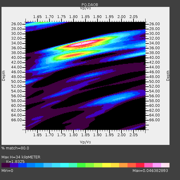
| Crust2 Type: | L8,thin continental arc, Cordilleras, 0.5 km seds. |
| Thickness Estimate: | 34 km |
| Thickness StdDev: | 2.6 km |
| Vp/Vs Estimate: | 1.88 |
| Vp/Vs StdDev: | 0.04 |
| Vs Estimate: | 3.488 km/s |
| Poisson's Ratio: | 0.30 |
| Peak Value: | 0.05 |
| Assumed Vp: | 6.566 km/s |
| Ps Weight: | 0.33333334 |
| PpPs Weight: | 0.33333334 |
| PsPs Weight: | 0.33333328 |
| Residual Complexity: | 0.610 |
| Nearby stations H: | +- |
| (2.0 deg) Vp/Vs: | +- |
4 with match > 90% ( 11.428572 %) and 9 with match > 80% ( 25.714285 %) out of 35.
Download stack as xyz text file.
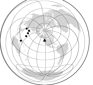
Azimuth Distribution of Events:
Prior Results for this Station
| Study | Thickness | Vp/Vs | Vp | Vs | Poissons Ratio | Extra |
| EARS | 34 km | 1.88 | 6.566 km/s | 3.488 km/s | 0.30 | |
| Crust2.0 | 34 km | 1.77 | 6.566 km/s | 3.707 km/s | 0.27 | L8,thin continental arc, Cordilleras, 0.5 km seds. |
| Global Maxima | 34 km | 1.88 | 6.566 km/s | 3.488 km/s | 0.30 | amp=0.046393126 |
| Local Maxima 1 | 33 km | 1.86 | 6.566 km/s | 3.535 km/s | 0.30 | amp=0.030693738 |
| Local Maxima 2 | 44 km | 1.75 | 6.566 km/s | 3.757 km/s | 0.26 | amp=0.027667105 |
| Local Maxima 3 | 26 km | 1.61 | 6.566 km/s | 4.091 km/s | 0.18 | amp=0.019471018 |
| Local Maxima 4 | 38 km | 1.89 | 6.566 km/s | 3.479 km/s | 0.30 | amp=0.015995914 |
| Predicted Arrivals for vertical incidence (zero ray parameter) | |
| Ps | 4.64 SECOND |
| PpPs | 15.15 SECOND |
| PsPs/PpSs | 19.78 SECOND |
Events Processed for this Station
Download zip of receiver functions as SAC
Plot maxima for each earthquake.
Events Used in the Stack
(9 events)| Radial Match | Distance | Baz | FERegion | Time | Lat/Lon | Depth | Magnitude |
| 97.16137 | 87.6 deg | 303.836 deg | Taiwan | 2024/04/02 23:58:11 UTC | (23.8, 121.6) | 35 km | 7.4 mww |
| 94.71353 | 77.4 deg | 131.918 deg | Near Coast Of Peru | 2024/06/28 05:36:37 UTC | (-15.8, -74.4) | 28 km | 7.2 mww |
| 93.396355 | 81.7 deg | 228.26 deg | Tonga Islands | 2024/05/26 20:47:09 UTC | (-19.4, -174.9) | 112 km | 6.6 mww |
| 91.29747 | 76.7 deg | 283.731 deg | Mariana Islands | 2024/04/05 11:03:16 UTC | (19.1, 145.4) | 222 km | 6.8 mww |
| 89.64375 | 74.3 deg | 302.376 deg | Shikoku, Japan | 2024/04/17 14:14:45 UTC | (33.2, 132.4) | 26 km | 6.3 mww |
| 88.44875 | 42.5 deg | 132.318 deg | Near Coast Of Chiapas, Mexico | 2024/05/12 11:39:14 UTC | (14.5, -92.4) | 75 km | 6.4 mww |
| 86.0667 | 95.4 deg | 269.926 deg | New Guinea, Papua New Guinea | 2024/03/23 20:22:07 UTC | (-4.1, 143.0) | 64 km | 7.0 Mi |
| 83.917496 | 77.5 deg | 132.054 deg | Near Coast Of Peru | 2024/06/16 14:47:31 UTC | (-15.9, -74.5) | 20 km | 6.0 mww |
| 81.08052 | 74.0 deg | 293.896 deg | Bonin Islands, Japan Region | 2024/04/27 08:35:34 UTC | (27.8, 139.6) | 503 km | 6.5 mww |
Losers
(26 events)| Radial Match | Distance | Baz | FERegion | Time | Lat/Lon | Depth | Magnitude | Reason |
| 79.93165 | 78.1 deg | 280.39 deg | Mariana Islands | 2024/04/02 09:54:09 UTC | (15.8, 146.9) | 10 km | 6.2 mww | |
| 78.24892 | 62.8 deg | 105.321 deg | Near Coast Of Venezuela | 2024/06/23 03:58:00 UTC | (10.8, -62.6) | 87 km | 6.0 mww | |
| 74.666275 | 72.0 deg | 298.434 deg | Southeast Of Honshu, Japan | 2024/05/29 17:14:58 UTC | (32.3, 137.6) | 392 km | 5.5 Mww | |
| 73.13697 | 87.5 deg | 303.86 deg | Taiwan | 2024/04/22 18:32:48 UTC | (23.9, 121.6) | 10 km | 6.1 Mww | |
| 70.865875 | 36.5 deg | 298.133 deg | Rat Islands, Aleutian Islands | 2024/03/30 16:28:57 UTC | (52.1, 178.4) | 115 km | 5.8 mww | |
| 70.453995 | 62.5 deg | 75.312 deg | Northern Mid-Atlantic Ridge | 2024/03/14 21:10:25 UTC | (29.8, -42.7) | 10 km | 6.0 mww | |
| 68.54125 | 85.7 deg | 246.568 deg | Santa Cruz Islands | 2024/05/21 09:50:43 UTC | (-12.1, 167.3) | 248 km | 5.4 Mww | |
| 67.62915 | 87.7 deg | 244.13 deg | Vanuatu Islands | 2024/05/08 08:17:15 UTC | (-15.1, 168.0) | 12 km | 6.1 mww | |
| 67.342636 | 87.6 deg | 303.768 deg | Taiwan | 2024/04/22 14:11:22 UTC | (23.7, 121.6) | 8.0 km | 5.8 mww | |
| 67.305145 | 39.2 deg | 232.721 deg | Hawaii | 2024/02/09 20:06:30 UTC | (19.0, -155.5) | 10 km | 6.3 Mi | |
| 66.70823 | 64.1 deg | 301.906 deg | Near East Coast Of Honshu, Japan | 2024/04/01 19:24:36 UTC | (40.1, 141.7) | 73 km | 5.9 mww | |
| 66.07616 | 91.7 deg | 224.556 deg | Kermadec Islands, New Zealand | 2024/02/09 10:57:48 UTC | (-29.9, -177.3) | 10 km | 6.1 mww | |
| 64.33204 | 45.2 deg | 4.724 deg | North Of Svalbard | 2024/05/19 02:31:21 UTC | (85.2, 12.1) | 10 km | 5.4 mww | |
| 63.81286 | 62.5 deg | 75.579 deg | Northern Mid-Atlantic Ridge | 2024/06/03 06:41:51 UTC | (29.6, -42.8) | 10 km | 5.9 mww | |
| 58.915707 | 54.6 deg | 307.849 deg | Sea Of Okhotsk | 2024/06/06 11:07:53 UTC | (50.1, 147.6) | 622 km | 5.9 mww | |
| 54.680958 | 93.9 deg | 225.267 deg | Kermadec Islands Region | 2024/04/25 05:07:36 UTC | (-31.3, -179.3) | 179 km | 5.5 mww | |
| 52.46714 | 78.7 deg | 228.908 deg | Tonga Islands | 2024/06/18 06:40:36 UTC | (-16.5, -173.8) | 35 km | 5.9 mww | |
| 52.375717 | 93.5 deg | 335.608 deg | Xizang | 2024/06/01 00:46:37 UTC | (34.2, 86.4) | 13 km | 5.6 mb | |
| 51.79535 | 89.3 deg | 243.002 deg | Vanuatu Islands | 2024/05/25 22:23:16 UTC | (-17.1, 167.9) | 29 km | 6.3 mww | |
| 49.58147 | 76.0 deg | 302.0 deg | Kyushu, Japan | 2024/04/08 01:25:29 UTC | (31.7, 131.4) | 54 km | 5.1 Mww | |
| 45.45109 | 68.5 deg | 302.442 deg | Near West Coast Of Honshu, Japan | 2024/06/02 21:31:38 UTC | (37.5, 137.2) | 4.8 km | 5.8 mww | |
| 44.45699 | 62.7 deg | 301.675 deg | Off East Coast Of Honshu, Japan | 2024/04/06 00:12:17 UTC | (40.9, 143.2) | 19 km | 5.4 Mww | |
| 41.53679 | 77.5 deg | 300.288 deg | Southeast Of Ryukyu Islands | 2024/04/15 22:38:57 UTC | (29.5, 131.7) | 8.0 km | 5.9 mww | |
| 40.18038 | 87.1 deg | 283.179 deg | W. Caroline Islands, Micronesia | 2024/02/14 11:40:21 UTC | (11.0, 138.6) | 10 km | 6.0 mww | |
| 33.848656 | 78.1 deg | 280.42 deg | Mariana Islands | 2024/04/02 22:16:44 UTC | (15.9, 146.9) | 10 km | 5.2 Mww | |
| 29.661848 | 66.2 deg | 127.384 deg | Northern Peru | 2024/06/18 02:22:09 UTC | (-3.9, -76.7) | 100 km | 5.5 Mww |

