
Station PR AUA1 - Aruba
Network: PR - Puerto Rico Seismic Network (PRSN) & Puerto Rico Strong Motion Program (PRSMP)
Nearby stations (2 deg radius)
| Station | Name | (Lat, Lon) | Start / End | Elevation |
| AUA1 | Aruba | (12.51, -70.01) | 2011-07-03 / 2599-12-31 | 70 m |
| Crust2 Type: | S3,continental slope, margin, transition 3.5 km seds. |
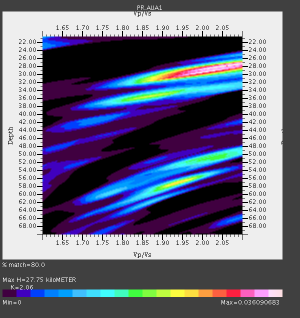
| Thickness Estimate: | 28 km |
| Thickness StdDev: | 10.0 km |
| Vp/Vs Estimate: | 2.06 |
| Vp/Vs StdDev: | 0.08 |
| Vs Estimate: | 2.855 km/s |
| Poisson's Ratio: | 0.35 |
| Peak Value: | 0.04 |
| Assumed Vp: | 5.88 km/s |
| Ps Weight: | 0.33333334 |
| PpPs Weight: | 0.33333334 |
| PsPs Weight: | 0.33333328 |
| Residual Complexity: | 0.728 |
| Nearby stations H: | +- |
| (2.0 deg) Vp/Vs: | +- |
4 with match > 90% ( 10.526316 %) and 10 with match > 80% ( 26.31579 %) out of 38.
Download stack as xyz text file.
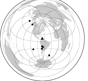
Azimuth Distribution of Events:
Prior Results for this Station
| Study | Thickness | Vp/Vs | Vp | Vs | Poissons Ratio | Extra |
| EARS | 28 km | 2.06 | 5.88 km/s | 2.855 km/s | 0.35 | |
| Crust2.0 | 26 km | 1.82 | 5.88 km/s | 3.237 km/s | 0.28 | S3,continental slope, margin, transition 3.5 km seds. |
| Global Maxima | 28 km | 2.06 | 5.88 km/s | 2.855 km/s | 0.35 | amp=0.036090683 |
| Local Maxima 1 | 30 km | 1.95 | 5.88 km/s | 3.023 km/s | 0.32 | amp=0.025517642 |
| Local Maxima 2 | 57 km | 1.94 | 5.88 km/s | 3.035 km/s | 0.32 | amp=0.024943644 |
| Local Maxima 3 | 34 km | 1.93 | 5.88 km/s | 3.047 km/s | 0.32 | amp=0.018479975 |
| Local Maxima 4 | 51 km | 1.98 | 5.88 km/s | 2.974 km/s | 0.33 | amp=0.016641198 |
| Predicted Arrivals for vertical incidence (zero ray parameter) | |
| Ps | 5.00 SECOND |
| PpPs | 14.44 SECOND |
| PsPs/PpSs | 19.44 SECOND |
Events Processed for this Station
Download zip of receiver functions as SAC
Plot maxima for each earthquake.
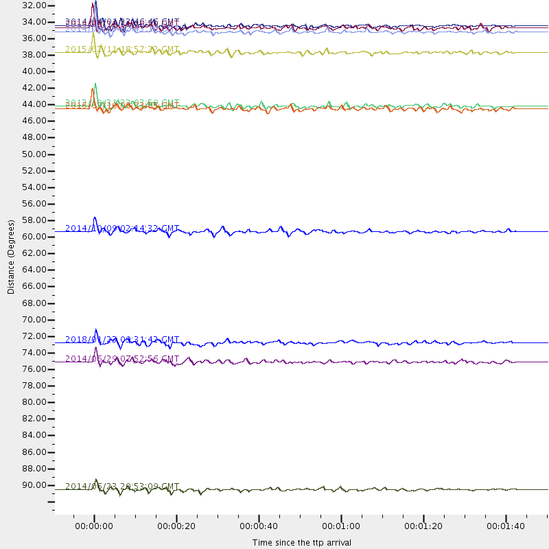
Events Used in the Stack
(10 events)| Radial Match | Distance | Baz | FERegion | Time | Lat/Lon | Depth | Magnitude |
| 92.73437 | 59.1 deg | 220.234 deg | Southern East Pacific Rise | 2014/10/09 02:14:32 GMT | (-32.1, -110.8) | 16 km | 7.1 MWW, 6.8 MI |
| 92.38307 | 32.0 deg | 181.436 deg | Near Coast Of Northern Chile | 2014/04/01 23:46:46 GMT | (-19.6, -70.8) | 20 km | 8.2 MWW, 8.0 MI, 8.1 MWC |
| 90.95799 | 92.9 deg | 324.576 deg | Rat Islands, Aleutian Islands | 2014/06/23 20:53:09 GMT | (51.8, 178.8) | 108 km | 7.9 MWW, 7.1 MI, 7.9 MWC |
| 90.7614 | 76.2 deg | 157.129 deg | South Sandwich Islands Region | 2014/06/29 07:52:56 GMT | (-55.5, -28.5) | 16 km | 6.9 MWW, 7.2 MI |
| 87.96734 | 32.8 deg | 180.843 deg | Near Coast Of Northern Chile | 2014/04/03 02:43:14 GMT | (-20.5, -70.5) | 31 km | 7.7 MWW, 7.4 MI, 7.7 MWC |
| 86.87541 | 35.5 deg | 174.738 deg | Jujuy Province, Argentina | 2015/02/11 18:57:22 GMT | (-23.1, -66.7) | 223 km | 6.7 MWW, 6.7 MWC, 6.7 MWB, 6.9 MI |
| 86.17191 | 32.2 deg | 181.089 deg | Near Coast Of Northern Chile | 2014/03/16 21:16:30 GMT | (-19.9, -70.6) | 20 km | 6.7 MWW, 6.7 MWC, 7.0 MI |
| 85.69803 | 73.6 deg | 324.955 deg | Gulf Of Alaska | 2018/01/23 09:31:42 GMT | (56.0, -149.1) | 25 km | 7.9 Mww |
| 85.4741 | 42.6 deg | 181.932 deg | Near Coast Of Central Chile | 2013/10/31 23:03:59 GMT | (-30.3, -71.5) | 27 km | 6.6 MWW, 6.4 MWB, 6.5 MWC, 6.6 MWW, 6.6 MI |
| 80.65364 | 42.9 deg | 182.037 deg | Near Coast Of Central Chile | 2016/02/10 00:33:05 GMT | (-30.6, -71.6) | 32 km | 6.3 MWB |
Losers
(28 events)| Radial Match | Distance | Baz | FERegion | Time | Lat/Lon | Depth | Magnitude | Reason |
| 92.652504 | 55.7 deg | 311.079 deg | Off Coast Of Northern California | 2014/03/10 05:18:13 GMT | (40.8, -125.1) | 17 km | 6.8 MW, 6.8 MWR, 6.9 MWW, 6.9 MWB, 7.0 MI, 7.0 MWC | |
| 91.64485 | 43.9 deg | 181.742 deg | Near Coast Of Central Chile | 2015/09/16 23:18:42 GMT | (-31.6, -71.4) | 31 km | 6.4 MB | |
| 87.659584 | 31.8 deg | 180.278 deg | Near Coast Of Northern Chile | 2014/04/01 23:59:57 GMT | (-19.5, -70.2) | 22 km | 5.8 MB | |
| 86.06661 | 42.6 deg | 181.995 deg | Near Coast Of Central Chile | 2015/10/03 06:26:55 GMT | (-30.3, -71.6) | 40 km | 5.8 MWR | |
| 78.424126 | 33.1 deg | 180.922 deg | Near Coast Of Northern Chile | 2014/04/03 05:26:16 GMT | (-20.8, -70.5) | 24 km | 6.2 MWP, 6.2 MWR, 6.3 MWW, 6.5 MWC | |
| 78.092735 | 30.0 deg | 283.099 deg | Guerrero, Mexico | 2014/05/08 17:00:17 GMT | (17.4, -100.7) | 24 km | 6.4 MWW, 6.8 MI | |
| 75.75715 | 59.7 deg | 320.823 deg | Vancouver Island, Canada Region | 2014/04/24 03:10:13 GMT | (49.8, -127.4) | 11 km | 6.7 MWP, 6.7 MI | |
| 74.10252 | 32.9 deg | 181.256 deg | Near Coast Of Northern Chile | 2014/04/04 01:37:51 GMT | (-20.6, -70.7) | 20 km | 6.1 MWP, 6.1 MWB, 6.1 MWW, 6.3 MWC | |
| 73.73165 | 43.4 deg | 181.999 deg | Near Coast Of Central Chile | 2015/09/19 09:07:08 GMT | (-31.1, -71.6) | 23 km | 6.1 MWP | |
| 73.684425 | 35.5 deg | 177.164 deg | Northern Chile | 2015/11/01 15:16:14 GMT | (-23.2, -68.2) | 80 km | 5.8 MB | |
| 73.28248 | 37.1 deg | 180.937 deg | Near Coast Of Northern Chile | 2015/11/27 21:00:22 GMT | (-24.8, -70.6) | 35 km | 6.2 MWW, 6.2 MWB | |
| 69.970726 | 58.1 deg | 227.578 deg | Easter Island Region | 2014/09/06 06:53:13 GMT | (-26.6, -114.5) | 10 km | 6.1 MB | |
| 69.73312 | 33.0 deg | 181.349 deg | Near Coast Of Northern Chile | 2014/01/04 00:11:48 GMT | (-20.7, -70.8) | 26 km | 5.7 MWW, 5.8 MWB, 5.8 MWC | |
| 65.41972 | 43.8 deg | 182.049 deg | Near Coast Of Central Chile | 2015/09/16 23:09:22 GMT | (-31.5, -71.7) | 10 km | 5.6 MB, 5.9 MB | |
| 61.94082 | 35.2 deg | 168.918 deg | Salta Province, Argentina | 2015/01/17 18:41:42 GMT | (-22.2, -63.1) | 557 km | 5.6 MWW, 5.6 MWB | |
| 61.583538 | 55.0 deg | 229.257 deg | Easter Island Region | 2013/11/02 15:52:46 GMT | (-23.6, -112.6) | 10 km | 6.0 MWW, 5.9 MWB, 6.0 MWW, 6.0 MWC, 6.1 MWC | |
| 60.6263 | 78.6 deg | 157.474 deg | South Sandwich Islands Region | 2015/08/26 13:51:39 GMT | (-57.5, -26.0) | 64 km | 5.7 MB | |
| 60.143936 | 88.4 deg | 52.618 deg | Dodecanese Islands, Greece | 2017/07/20 22:31:12 GMT | (36.9, 27.5) | 10 km | 6.7 Mww | |
| 59.95966 | 77.6 deg | 157.571 deg | South Sandwich Islands Region | 2014/02/01 03:58:43 GMT | (-56.8, -27.3) | 130 km | 6.1 MWW, 6.1 MWC, 6.1 MWB, 6.2 MWC | |
| 59.418125 | 45.1 deg | 176.487 deg | Mendoza Province, Argentina | 2015/02/02 10:49:48 GMT | (-32.7, -67.1) | 172 km | 6.3 MO | |
| 58.52893 | 32.1 deg | 169.135 deg | Southern Bolivia | 2014/01/27 16:42:37 GMT | (-19.3, -63.9) | 600 km | 5.6 MWB | |
| 57.058506 | 33.1 deg | 181.068 deg | Near Coast Of Northern Chile | 2014/01/08 04:22:10 GMT | (-20.7, -70.6) | 20 km | 5.7 MWW, 5.6 MWB, 5.6 MWR, 5.7 MWC | |
| 51.76067 | 35.6 deg | 176.272 deg | Chile-Argentina Border Region | 2017/04/15 08:19:41 GMT | (-23.2, -67.7) | 135 km | 6.2 Mww | |
| 51.66445 | 95.2 deg | 212.966 deg | Pacific-Antarctic Ridge | 2014/12/16 10:45:26 GMT | (-56.8, -150.4) | 10 km | 5.5 MB | |
| 49.54759 | 34.9 deg | 169.841 deg | Salta Province, Argentina | 2018/03/02 04:42:14 GMT | (-22.1, -63.8) | 526 km | 5.4 Mww | |
| 45.167408 | 53.2 deg | 99.567 deg | North Of Ascension Island | 2018/02/15 08:27:22 GMT | (-0.1, -17.8) | 10 km | 5.6 Mww | |
| 38.935688 | 41.0 deg | 296.33 deg | Gulf Of California | 2018/01/19 16:17:42 GMT | (26.7, -111.1) | 10 km | 6.3 Mww | |
| 22.381634 | 93.8 deg | 143.481 deg | Southwest Of Africa | 2018/01/28 16:03:03 GMT | (-53.1, 9.7) | 10 km | 6.6 Mww |

