
Station PR CDVI - ST. CROIX VI (4125)
Network: PR - Puerto Rico Seismic Network (PRSN) & Puerto Rico Strong Motion Program (PRSMP)
Nearby stations (2 deg radius)
| Station | Name | (Lat, Lon) | Start / End | Elevation |
| CDVI | ST. CROIX VI (4125) | (17.73, -64.71) | 2004-12-09 / 2499-01-01 | 71 m |
| Crust2 Type: | S2,continental slope, margin, transition 2 km seds. |
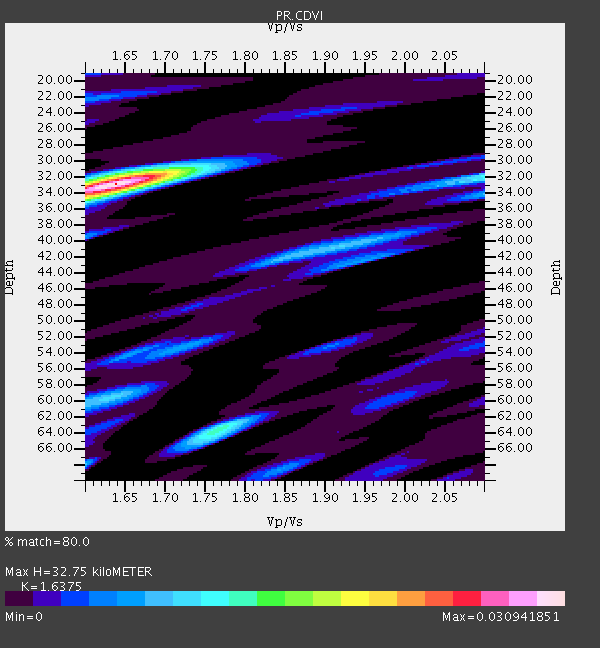
| Thickness Estimate: | 33 km |
| Thickness StdDev: | 8.5 km |
| Vp/Vs Estimate: | 1.64 |
| Vp/Vs StdDev: | 0.20 |
| Vs Estimate: | 3.693 km/s |
| Poisson's Ratio: | 0.20 |
| Peak Value: | 0.03 |
| Assumed Vp: | 6.048 km/s |
| Ps Weight: | 0.33333334 |
| PpPs Weight: | 0.33333334 |
| PsPs Weight: | 0.33333328 |
| Residual Complexity: | 0.558 |
| Nearby stations H: | +- |
| (2.0 deg) Vp/Vs: | +- |
0 with match > 90% ( 0.0 %) and 6 with match > 80% ( 24.0 %) out of 25.
Download stack as xyz text file.
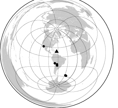
Azimuth Distribution of Events:
Prior Results for this Station
| Study | Thickness | Vp/Vs | Vp | Vs | Poissons Ratio | Extra |
| EARS | 33 km | 1.64 | 6.048 km/s | 3.693 km/s | 0.20 | |
| Crust2.0 | 24 km | 1.81 | 6.048 km/s | 3.34 km/s | 0.28 | S2,continental slope, margin, transition 2 km seds. |
| Global Maxima | 33 km | 1.64 | 6.048 km/s | 3.693 km/s | 0.20 | amp=0.030941851 |
| Local Maxima 1 | 64 km | 1.76 | 6.048 km/s | 3.427 km/s | 0.26 | amp=0.013627676 |
| Local Maxima 2 | 32 km | 2.10 | 6.048 km/s | 2.883 km/s | 0.35 | amp=0.011407605 |
| Local Maxima 3 | 60 km | 1.63 | 6.048 km/s | 3.705 km/s | 0.20 | amp=0.009729599 |
| Local Maxima 4 | 40 km | 1.92 | 6.048 km/s | 3.15 km/s | 0.31 | amp=0.009221372 |
| Predicted Arrivals for vertical incidence (zero ray parameter) | |
| Ps | 3.45 SECOND |
| PpPs | 14.28 SECOND |
| PsPs/PpSs | 17.73 SECOND |
Events Processed for this Station
Download zip of receiver functions as SAC
Plot maxima for each earthquake.
Events Used in the Stack
(6 events)| Radial Match | Distance | Baz | FERegion | Time | Lat/Lon | Depth | Magnitude |
| 87.29833 | 82.3 deg | 158.825 deg | South Sandwich Islands Region | 2008/02/23 15:57:19 GMT | (-57.3, -23.4) | 10 km | 6.2 MB, 6.7 MS, 6.7 MW, 6.7 MW |
| 83.919846 | 80.4 deg | 159.861 deg | South Sandwich Islands Region | 2011/03/06 14:32:36 GMT | (-56.4, -27.1) | 88 km | 6.6 MB, 6.5 MW, 6.5 MW |
| 81.83648 | 40.2 deg | 178.365 deg | Salta Province, Argentina | 2012/11/22 13:07:10 GMT | (-22.7, -63.6) | 517 km | 5.6 MB, 5.9 MW, 6.0 MW |
| 81.60066 | 44.6 deg | 292.304 deg | Gulf Of California | 2006/01/04 08:32:32 GMT | (28.2, -112.1) | 14 km | 6.1 MB, 6.7 MS, 6.6 MW, 6.5 MW |
| 81.05109 | 44.2 deg | 178.09 deg | Santiago Del Estero Prov., Arg. | 2008/09/03 11:25:14 GMT | (-26.7, -63.2) | 570 km | 5.9 MB, 6.3 MW, 6.3 MW |
| 80.06689 | 37.5 deg | 188.953 deg | Near Coast Of Northern Chile | 2009/04/17 02:08:08 GMT | (-19.6, -70.5) | 25 km | 5.8 MB, 5.8 MS, 6.1 MW, 6.1 MW |
Losers
(19 events)| Radial Match | Distance | Baz | FERegion | Time | Lat/Lon | Depth | Magnitude | Reason |
| 79.66302 | 45.5 deg | 177.992 deg | Santiago Del Estero Prov., Arg. | 2012/05/28 05:07:23 GMT | (-28.0, -63.1) | 587 km | 6.0 MB, 6.7 MW, 6.8 MW | |
| 78.17774 | 39.6 deg | 178.311 deg | Salta Province, Argentina | 2012/06/02 07:52:53 GMT | (-22.1, -63.6) | 527 km | 5.8 MB, 5.9 MW, 6.0 MW | |
| 76.22902 | 39.3 deg | 185.158 deg | Chile-Bolivia Border Region | 2011/06/20 16:36:01 GMT | (-21.7, -68.2) | 128 km | 6.0 MB, 6.5 MW, 6.5 MW | |
| 74.894485 | 68.3 deg | 126.647 deg | South Atlantic Ocean | 2012/06/29 15:31:46 GMT | (-24.7, -9.7) | 10 km | 6.0 MB, 5.2 MS, 5.8 MW, 5.8 MW | |
| 74.31024 | 35.5 deg | 188.02 deg | Peru-Bolivia Border Region | 2012/05/14 10:00:40 GMT | (-17.7, -69.6) | 106 km | 6.4 MB, 6.2 MW, 6.2 MW | |
| 72.97082 | 83.4 deg | 158.858 deg | South Sandwich Islands Region | 2008/06/30 06:17:44 GMT | (-58.2, -22.1) | 19 km | 6.1 MB, 6.7 MS, 7.0 MW, 6.9 MW | |
| 72.930405 | 33.7 deg | 199.248 deg | Near Coast Of Peru | 2012/07/02 23:31:37 GMT | (-14.4, -75.6) | 40 km | 6.0 MB, 5.2 MS, 5.7 MW, 5.6 MW | |
| 70.787094 | 83.0 deg | 160.26 deg | South Sandwich Islands Region | 2008/04/28 15:57:55 GMT | (-58.7, -24.7) | 35 km | 5.5 MB, 5.9 MS, 6.1 MW, 6.0 MW | |
| 70.0317 | 81.3 deg | 160.156 deg | South Sandwich Islands Region | 2010/06/02 01:49:03 GMT | (-57.4, -26.4) | 127 km | 5.9 MB, 5.9 MW, 5.9 MW | |
| 69.764084 | 46.4 deg | 245.342 deg | Central East Pacific Rise | 2008/09/18 01:41:02 GMT | (-4.6, -106.0) | 10 km | 5.5 MB, 5.7 MS, 6.0 MW, 6.0 MW | |
| 69.01136 | 51.8 deg | 187.566 deg | Near Coast Of Central Chile | 2012/11/21 21:36:22 GMT | (-33.9, -71.9) | 18 km | 5.7 MB, 5.5 MS, 5.9 MW, 5.8 MW | |
| 67.7112 | 67.4 deg | 17.503 deg | Norwegian Sea | 2012/05/24 22:47:46 GMT | (73.0, 5.7) | 10 km | 5.7 MB, 6.1 MS, 6.1 MW, 6.2 MW | |
| 62.16391 | 91.7 deg | 325.716 deg | Rat Islands, Aleutian Islands | 2008/07/25 00:29:22 GMT | (51.3, 179.0) | 21 km | 5.7 MB, 5.5 MS, 5.9 MW, 5.9 MW | |
| 60.670418 | 49.7 deg | 185.525 deg | Mendoza Province, Argentina | 2009/05/08 13:44:53 GMT | (-32.1, -69.7) | 112 km | 5.6 MB, 5.4 MW | |
| 60.504147 | 39.4 deg | 185.062 deg | Chile-Bolivia Border Region | 2012/10/08 01:50:26 GMT | (-21.7, -68.2) | 122 km | 6.0 MB, 5.7 MW, 5.8 MW | |
| 58.106873 | 40.9 deg | 182.805 deg | Jujuy Province, Argentina | 2010/01/28 08:04:14 GMT | (-23.4, -66.7) | 208 km | 5.8 MB, 5.9 MW, 5.9 MW | |
| 55.24902 | 58.7 deg | 119.347 deg | Southern Mid-Atlantic Ridge | 2010/01/27 17:42:45 GMT | (-14.1, -14.6) | 10 km | 6.0 MB, 5.6 MS, 5.8 MW, 5.8 MW | |
| 55.212708 | 55.5 deg | 188.274 deg | Near Coast Of Central Chile | 2010/08/05 06:01:47 GMT | (-37.4, -73.3) | 18 km | 5.5 MS, 5.4 MB, 5.9 MW, 5.8 MW | |
| 53.142895 | 90.0 deg | 325.767 deg | Andreanof Islands, Aleutian Is. | 2008/03/22 21:24:11 GMT | (52.2, -178.7) | 132 km | 5.8 MB, 6.2 MW, 6.1 MW |
