
Station PR ICM - Isla Caja Muertos, PR(T4128)
Network: PR - Puerto Rico Seismic Network (PRSN) & Puerto Rico Strong Motion Program (PRSMP)
Nearby stations (2 deg radius)
| Station | Name | (Lat, Lon) | Start / End | Elevation |
| ICM | Isla Caja Muertos, PR(T4128) | (17.89, -66.52) | 2001-01-25 / 2499-01-01 | 77 m |
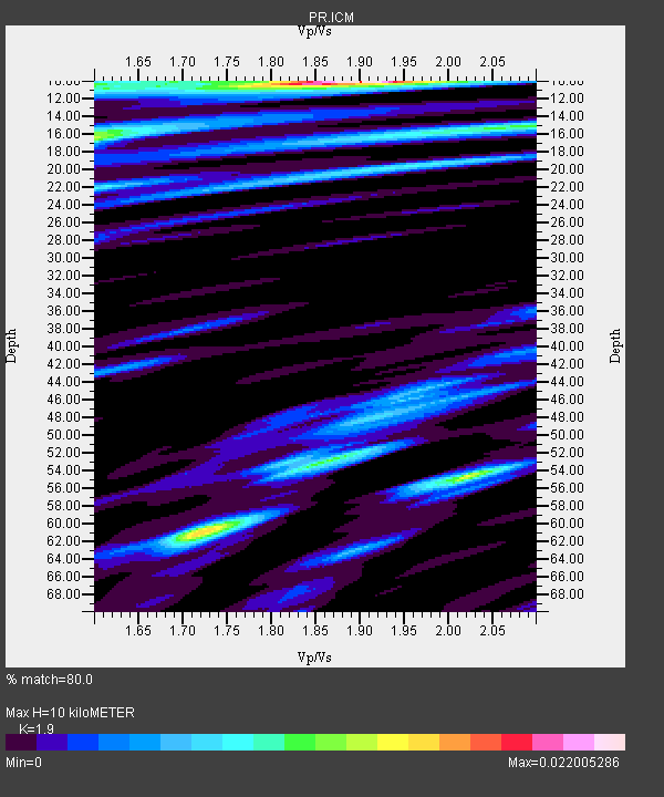
| Crust2 Type: | A2,normal oceanic 1 km seds. |
| Thickness Estimate: | 10 km |
| Thickness StdDev: | 19 km |
| Vp/Vs Estimate: | 1.90 |
| Vp/Vs StdDev: | 0.14 |
| Vs Estimate: | 2.149 km/s |
| Poisson's Ratio: | 0.31 |
| Peak Value: | 0.02 |
| Assumed Vp: | 4.082 km/s |
| Ps Weight: | 0.33333334 |
| PpPs Weight: | 0.33333334 |
| PsPs Weight: | 0.33333328 |
| Residual Complexity: | 0.789 |
| Nearby stations H: | +- |
| (2.0 deg) Vp/Vs: | +- |
0 with match > 90% ( 0.0 %) and 9 with match > 80% ( 33.333332 %) out of 27.
Download stack as xyz text file.
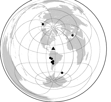
Azimuth Distribution of Events:
Prior Results for this Station
| Study | Thickness | Vp/Vs | Vp | Vs | Poissons Ratio | Extra |
| EARS | 10 km | 1.90 | 4.082 km/s | 2.149 km/s | 0.31 | |
| Crust2.0 | 12 km | 2.18 | 4.082 km/s | 1.872 km/s | 0.37 | A2,normal oceanic 1 km seds. |
| Global Maxima | 10 km | 1.90 | 4.082 km/s | 2.149 km/s | 0.31 | amp=0.022005286 |
| Local Maxima 1 | 61 km | 1.72 | 4.082 km/s | 2.377 km/s | 0.24 | amp=0.015241695 |
| Local Maxima 2 | 54 km | 2.02 | 4.082 km/s | 2.021 km/s | 0.34 | amp=0.011950515 |
| Local Maxima 3 | 53 km | 1.87 | 4.082 km/s | 2.189 km/s | 0.30 | amp=0.011062732 |
| Local Maxima 4 | 16 km | 1.60 | 4.082 km/s | 2.551 km/s | 0.18 | amp=0.010660573 |
| Predicted Arrivals for vertical incidence (zero ray parameter) | |
| Ps | 2.20 SECOND |
| PpPs | 7.10 SECOND |
| PsPs/PpSs | 9.31 SECOND |
Events Processed for this Station
Download zip of receiver functions as SAC
Plot maxima for each earthquake.
Events Used in the Stack
(9 events)| Radial Match | Distance | Baz | FERegion | Time | Lat/Lon | Depth | Magnitude |
| 88.743095 | 90.5 deg | 336.864 deg | Eastern Siberia, Russia | 2006/04/20 23:25:02 GMT | (60.9, 167.1) | 22 km | 6.8 MB, 7.6 MS, 7.6 MW, 7.3 MW |
| 88.60334 | 32.7 deg | 198.502 deg | Near Coast Of Peru | 2006/10/20 10:48:56 GMT | (-13.5, -76.7) | 23 km | 5.9 MB, 6.6 MS, 6.7 MW, 6.6 MW |
| 86.83219 | 79.4 deg | 55.252 deg | Southern Greece | 2006/01/08 11:34:55 GMT | (36.3, 23.2) | 66 km | 6.5 MB, 6.7 MW, 6.7 MW |
| 84.87742 | 86.4 deg | 159.779 deg | Southwestern Atlantic Ocean | 2006/01/02 06:10:49 GMT | (-60.9, -21.6) | 10 km | 6.4 MB, 7.3 MS, 7.4 MW, 7.1 MW |
| 83.45775 | 44.8 deg | 185.618 deg | Near Coast Of Northern Chile | 2006/04/30 19:17:17 GMT | (-27.0, -71.0) | 27 km | 6.0 MB, 6.4 MS, 6.7 MW, 6.6 MW |
| 82.93518 | 49.4 deg | 180.735 deg | San Juan Province, Argentina | 2006/09/17 09:34:14 GMT | (-31.7, -67.2) | 142 km | 5.7 MB, 6.2 MW, 6.2 MW |
| 82.5487 | 34.1 deg | 189.002 deg | Southern Peru | 2008/07/08 09:13:07 GMT | (-16.0, -71.7) | 123 km | 5.8 MB, 6.2 MW, 6.2 MW |
| 81.55714 | 42.0 deg | 180.69 deg | Chile-Argentina Border Region | 2006/08/25 00:44:46 GMT | (-24.4, -67.0) | 184 km | 5.9 MB, 6.6 MW, 6.6 MW |
| 80.807335 | 45.1 deg | 185.71 deg | Near Coast Of Northern Chile | 2006/04/30 21:40:58 GMT | (-27.2, -71.1) | 12 km | 5.9 MB, 6.7 MS, 6.5 MW, 6.3 ML |
Losers
(18 events)| Radial Match | Distance | Baz | FERegion | Time | Lat/Lon | Depth | Magnitude | Reason |
| 78.621735 | 44.9 deg | 243.93 deg | Central East Pacific Rise | 2008/09/18 01:41:02 GMT | (-4.6, -106.0) | 10 km | 5.5 MB, 5.7 MS, 6.0 MW, 6.0 MW | |
| 73.97578 | 32.5 deg | 104.812 deg | Central Mid-Atlantic Ridge | 2008/05/23 19:35:34 GMT | (7.3, -34.9) | 9.0 km | 6.0 MB, 6.4 MS, 6.5 MW, 6.5 MW | |
| 72.63186 | 44.5 deg | 175.792 deg | Santiago Del Estero Prov., Arg. | 2008/09/03 11:25:14 GMT | (-26.7, -63.2) | 570 km | 5.9 MB, 6.3 MW, 6.3 MW | |
| 71.5961 | 38.0 deg | 184.123 deg | Northern Chile | 2008/09/10 16:12:04 GMT | (-20.3, -69.2) | 38 km | 5.6 MB, 5.3 MS | |
| 70.728836 | 84.2 deg | 158.142 deg | South Sandwich Islands Region | 2008/06/30 06:17:44 GMT | (-58.2, -22.1) | 19 km | 6.1 MB, 6.7 MS, 7.0 MW, 6.9 MW | |
| 68.27404 | 51.6 deg | 105.075 deg | North Of Ascension Island | 2008/08/28 15:22:23 GMT | (-0.2, -17.4) | 15 km | 5.8 MB, 5.9 MS, 6.3 MW, 6.3 MW | |
| 65.60786 | 50.3 deg | 185.72 deg | Near Coast Of Central Chile | 2008/12/18 21:19:28 GMT | (-32.5, -71.7) | 18 km | 5.8 MB, 6.0 MS, 6.2 MW, 6.1 MW | |
| 63.227245 | 40.5 deg | 110.466 deg | Central Mid-Atlantic Ridge | 2008/09/16 07:28:25 GMT | (0.9, -29.0) | 10 km | 5.8 MW, 5.2 MS, 5.2 MB, 5.8 MW | |
| 63.20671 | 60.4 deg | 58.493 deg | Northern Algeria | 2008/06/06 20:02:56 GMT | (35.9, -0.7) | 4.0 km | 5.5 MB, 5.3 MS, 5.5 MW, 5.5 MW | |
| 62.51182 | 56.2 deg | 306.888 deg | Off Coast Of Northern California | 2008/11/28 13:42:18 GMT | (40.3, -127.0) | 10 km | 5.5 MS, 5.4 MB, 5.9 MW, 5.9 MW | |
| 56.60164 | 37.8 deg | 177.624 deg | Southern Bolivia | 2008/10/12 20:55:41 GMT | (-20.1, -65.0) | 353 km | 6.0 MB, 6.2 MW, 6.2 MW | |
| 55.56005 | 50.7 deg | 105.561 deg | Central Mid-Atlantic Ridge | 2008/07/27 21:15:41 GMT | (-0.3, -18.3) | 10 km | 5.8 MB, 5.3 MS, 5.9 MW, 5.8 MW | |
| 55.216045 | 59.3 deg | 318.152 deg | Vancouver Island, Canada Region | 2008/08/28 12:37:34 GMT | (50.2, -129.6) | 10 km | 5.6 MS, 5.3 MB, 5.9 MW, 5.9 MW | |
| 54.17346 | 90.6 deg | 325.14 deg | Rat Islands, Aleutian Islands | 2008/07/25 00:29:22 GMT | (51.3, 179.0) | 21 km | 5.7 MB, 5.5 MS, 5.9 MW, 5.9 MW | |
| 49.795776 | 78.9 deg | 180.6 deg | Drake Passage | 2008/08/31 01:15:25 GMT | (-61.2, -67.7) | 10 km | 5.6 MB, 4.9 MS, 5.5 MW, 5.5 MW | |
| 46.73995 | 46.0 deg | 183.397 deg | Chile-Argentina Border Region | 2008/03/10 09:43:01 GMT | (-28.3, -69.3) | 90 km | 5.6 MB, 5.6 MW | |
| 43.110004 | 80.5 deg | 159.249 deg | South Sandwich Islands Region | 2008/04/14 09:45:19 GMT | (-56.0, -28.0) | 140 km | 6.0 MB, 6.0 MW, 6.0 MW | |
| 39.855175 | 83.7 deg | 159.529 deg | South Sandwich Islands Region | 2008/04/28 15:57:55 GMT | (-58.7, -24.7) | 35 km | 5.5 MB, 5.9 MS, 6.1 MW, 6.0 MW |
