
Station PT KEKH - Kekaha, Kauai, Hawaii
Network: PT - Pacific Tsunami Warning Seismic System
Nearby stations (2 deg radius)
| Station | Name | (Lat, Lon) | Start / End | Elevation |
| KEKH | Kekaha, Kauai, Hawaii | (21.98, -159.71) | 2007-07-13 / 2599-12-31 | 54 m |
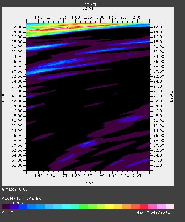
| Crust2 Type: | A0,normal oceanic, 0.07 km seds. |
| Thickness Estimate: | 12 km |
| Thickness StdDev: | 2.4 km |
| Vp/Vs Estimate: | 1.76 |
| Vp/Vs StdDev: | 0.09 |
| Vs Estimate: | 2.402 km/s |
| Poisson's Ratio: | 0.26 |
| Peak Value: | 0.04 |
| Assumed Vp: | 4.24 km/s |
| Ps Weight: | 0.33333334 |
| PpPs Weight: | 0.33333334 |
| PsPs Weight: | 0.33333328 |
| Residual Complexity: | 0.533 |
| Nearby stations H: | +- |
| (2.0 deg) Vp/Vs: | +- |
6 with match > 90% ( 18.181818 %) and 8 with match > 80% ( 24.242424 %) out of 33.
Download stack as xyz text file.
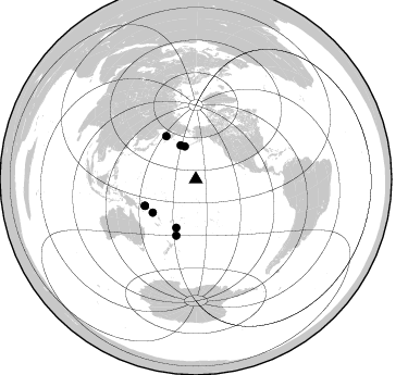
Azimuth Distribution of Events:
Prior Results for this Station
| Study | Thickness | Vp/Vs | Vp | Vs | Poissons Ratio | Extra |
| EARS | 12 km | 1.76 | 4.24 km/s | 2.402 km/s | 0.26 | |
| Crust2.0 | 12 km | 2.19 | 4.24 km/s | 1.94 km/s | 0.37 | A0,normal oceanic, 0.07 km seds. |
| Global Maxima | 12 km | 1.76 | 4.24 km/s | 2.402 km/s | 0.26 | amp=0.042395487 |
| Local Maxima 1 | 15 km | 1.60 | 4.24 km/s | 2.65 km/s | 0.18 | amp=0.03041741 |
| Local Maxima 2 | 11 km | 1.74 | 4.24 km/s | 2.433 km/s | 0.25 | amp=0.025113732 |
| Local Maxima 3 | 20 km | 1.61 | 4.24 km/s | 2.633 km/s | 0.19 | amp=0.0162194 |
| Local Maxima 4 | 30 km | 1.65 | 4.24 km/s | 2.562 km/s | 0.21 | amp=0.011452192 |
| Predicted Arrivals for vertical incidence (zero ray parameter) | |
| Ps | 2.17 SECOND |
| PpPs | 7.83 SECOND |
| PsPs/PpSs | 9.99 SECOND |
Events Processed for this Station
Download zip of receiver functions as SAC
Plot maxima for each earthquake.
Events Used in the Stack
(8 events)| Radial Match | Distance | Baz | FERegion | Time | Lat/Lon | Depth | Magnitude |
| 96.45285 | 52.8 deg | 242.515 deg | Solomon Islands | 2014/04/19 13:27:59 GMT | (-6.7, 154.9) | 31 km | 7.5 MWW, 7.8 MI |
| 95.47244 | 49.9 deg | 232.255 deg | Solomon Islands | 2014/04/12 20:14:39 GMT | (-11.3, 162.2) | 29 km | 7.6 MWW, 8.3 MI |
| 92.75529 | 47.9 deg | 201.966 deg | South Of Fiji Islands | 2013/05/23 17:19:04 GMT | (-23.0, -177.2) | 174 km | 7.4 MW, 6.6 MB, 7.4 MW |
| 92.57134 | 48.0 deg | 325.314 deg | Sea Of Okhotsk | 2013/05/24 05:44:48 GMT | (54.9, 153.2) | 598 km | 8.4 MW, 7.5 MB, 8.3 MW |
| 92.29775 | 34.1 deg | 336.027 deg | Rat Islands, Aleutian Islands | 2014/06/23 20:53:09 GMT | (51.8, 178.8) | 108 km | 7.9 MWW, 7.1 MI, 7.9 MWC |
| 91.09783 | 31.9 deg | 341.551 deg | Andreanof Islands, Aleutian Is. | 2013/08/30 16:25:02 GMT | (51.5, -175.2) | 29 km | 7.0 MWW, 6.5 ML, 6.8 MI, 6.9 MWC, 6.9 MWB, 7.0 MWW, 7.0 MI, 7.0 MWC |
| 88.57132 | 54.6 deg | 199.131 deg | Kermadec Islands, New Zealand | 2014/06/23 19:19:16 GMT | (-30.1, -177.7) | 20 km | 6.9 MWW, 6.7 MWB, 7.2 MI |
| 82.67983 | 52.6 deg | 242.521 deg | Solomon Islands | 2014/04/11 07:07:21 GMT | (-6.6, 155.1) | 50 km | 7.1 MWW, 7.0 MWB, 7.3 MI |
Losers
(25 events)| Radial Match | Distance | Baz | FERegion | Time | Lat/Lon | Depth | Magnitude | Reason |
| 95.24656 | 50.1 deg | 232.243 deg | Solomon Islands | 2014/04/13 12:36:18 GMT | (-11.5, 162.1) | 35 km | 7.4 MWW, 7.7 MI | |
| 78.93048 | 55.3 deg | 83.382 deg | Guerrero, Mexico | 2014/04/18 14:27:26 GMT | (17.6, -100.8) | 24 km | 7.2 MWW, 7.0 MWB, 7.3 MWC, 7.5 MI | |
| 75.89546 | 56.8 deg | 246.639 deg | New Britain Region, P.N.G. | 2013/07/07 20:30:06 GMT | (-6.0, 149.7) | 56 km | 6.6 MW, 6.1 MB, 6.6 MW | |
| 74.75341 | 96.2 deg | 108.863 deg | Near Coast Of Northern Chile | 2014/04/01 23:57:57 GMT | (-19.9, -70.9) | 20 km | 6.9 MWW, 6.9 MWC | |
| 70.61329 | 48.0 deg | 321.458 deg | Sea Of Okhotsk | 2013/05/24 14:56:31 GMT | (52.2, 151.4) | 624 km | 6.7 MW, 6.7 MB, 6.7 MW | |
| 66.34166 | 50.6 deg | 313.395 deg | Sea Of Okhotsk | 2013/08/04 15:56:34 GMT | (47.0, 145.2) | 375 km | 5.8 MW, 5.8 MW | |
| 65.01713 | 55.4 deg | 199.364 deg | Kermadec Islands, New Zealand | 2013/10/24 00:25:46 GMT | (-30.8, -178.2) | 49 km | 5.5 MWW, 5.5 MWW, 5.6 MWC | |
| 62.545387 | 52.7 deg | 242.8 deg | Solomon Islands | 2013/10/16 10:30:58 GMT | (-6.4, 154.9) | 35 km | 6.8 MWW, 6.7 MWB, 6.8 MWW, 6.8 MWC, 7.1 MI | |
| 59.876926 | 43.3 deg | 328.595 deg | Near East Coast Of Kamchatka | 2013/11/12 07:03:51 GMT | (54.7, 162.3) | 43 km | 6.4 MWW, 6.3 MWC, 6.4 MWW, 6.4 MWB, 6.5 MWC, 6.6 MI | |
| 58.913914 | 52.0 deg | 204.109 deg | South Of Fiji Islands | 2014/03/26 03:36:25 GMT | (-26.1, 179.3) | 510 km | 6.1 MB | |
| 58.41491 | 31.7 deg | 341.341 deg | Andreanof Islands, Aleutian Is. | 2013/08/31 06:43:54 GMT | (51.4, -175.3) | 25 km | 5.5 MW, 5.5 MWC, 5.5 MWC | |
| 57.54587 | 52.9 deg | 242.994 deg | Solomon Islands | 2013/04/14 01:32:22 GMT | (-6.5, 154.6) | 31 km | 6.5 MW, 6.0 MB, 6.5 MS, 6.6 MW | |
| 57.310997 | 91.4 deg | 297.552 deg | Myanmar-China Border Region | 2014/05/23 20:49:24 GMT | (25.0, 97.9) | 25 km | 5.6 MB | |
| 56.43683 | 51.9 deg | 204.169 deg | South Of Fiji Islands | 2014/03/26 03:29:36 GMT | (-26.1, 179.3) | 493 km | 6.5 MWP, 6.3 MWW, 6.3 MWC, 6.4 MWB, 6.4 MWC, 6.5 MI | |
| 56.417973 | 70.7 deg | 84.97 deg | Near Coast Of Nicaragua | 2014/04/11 20:29:13 GMT | (11.6, -86.0) | 135 km | 6.6 MWW, 6.6 MWC, 6.6 MWB, 6.6 MI | |
| 56.27582 | 50.7 deg | 205.165 deg | South Of Fiji Islands | 2014/05/04 09:15:53 GMT | (-24.6, 179.1) | 528 km | 6.6 MWP, 6.8 MI | |
| 56.129223 | 32.9 deg | 346.691 deg | Fox Islands, Aleutian Islands | 2014/02/26 21:13:40 GMT | (53.6, -171.8) | 265 km | 6.1 MWW, 5.9 MI, 5.9 ML, 6.1 MWC, 6.1 MWB, 6.2 MWC | |
| 55.996292 | 47.6 deg | 323.07 deg | Sea Of Okhotsk | 2013/10/01 03:38:21 GMT | (53.2, 152.8) | 573 km | 6.7 MWW, 6.7 MWC, 6.8 MWC, 6.8 MWB | |
| 55.77861 | 76.3 deg | 256.379 deg | Banda Sea | 2014/02/03 22:36:37 GMT | (-7.2, 128.2) | 7.1 km | 5.8 MWW, 5.8 MWB, 5.9 MWC | |
| 53.997578 | 51.0 deg | 300.362 deg | Off East Coast Of Honshu, Japan | 2014/01/04 05:23:00 GMT | (37.0, 143.4) | 22 km | 5.5 MWB | |
| 53.414505 | 52.7 deg | 242.45 deg | Solomon Islands | 2014/04/19 01:04:03 GMT | (-6.7, 155.1) | 24 km | 6.6 MWB, 6.9 MI, 7.0 MI | |
| 51.76713 | 55.3 deg | 291.899 deg | Southeast Of Honshu, Japan | 2013/09/04 00:18:23 GMT | (29.9, 138.8) | 402 km | 6.5 MWW, 6.5 MWW, 6.5 MWB, 6.5 MWC | |
| 50.131954 | 44.9 deg | 200.029 deg | Tonga Islands | 2014/04/26 06:02:16 GMT | (-20.7, -174.7) | 10 km | 6.5 MWP | |
| 46.73195 | 83.3 deg | 160.144 deg | Southern East Pacific Rise | 2013/04/06 10:29:20 GMT | (-55.6, -123.2) | 9.9 km | 5.5 MW | |
| 41.247368 | 73.8 deg | 271.41 deg | Mindanao, Philippines | 2013/06/01 14:10:06 GMT | (7.3, 124.9) | 10 km | 5.6 MW, 5.6 MW, 5.7 MB |
