
Station S AUCAR - St Mary Star of the Sea, Carnarvon, WA
Network: S - Seismographs in Schools Projects
Nearby stations (2 deg radius)
| Station | Name | (Lat, Lon) | Start / End | Elevation |
| AUCAR | St Mary Star of the Sea, Carnarvon, WA | (-24.89, 113.66) | 2013-09-03 / 2599-12-31 | 17 m |
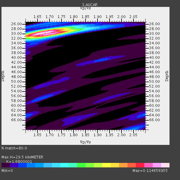
| Crust2 Type: | C4,continental shelf, 3.5 km seds. |
| Thickness Estimate: | 30 km |
| Thickness StdDev: | 0.3 km |
| Vp/Vs Estimate: | 1.68 |
| Vp/Vs StdDev: | 0.02 |
| Vs Estimate: | 3.565 km/s |
| Poisson's Ratio: | 0.23 |
| Peak Value: | 0.11 |
| Assumed Vp: | 5.989 km/s |
| Ps Weight: | 0.33333334 |
| PpPs Weight: | 0.33333334 |
| PsPs Weight: | 0.33333328 |
| Residual Complexity: | 0.385 |
| Nearby stations H: | +- |
| (2.0 deg) Vp/Vs: | +- |
3 with match > 90% ( 15.789474 %) and 4 with match > 80% ( 21.052631 %) out of 19.
Download stack as xyz text file.
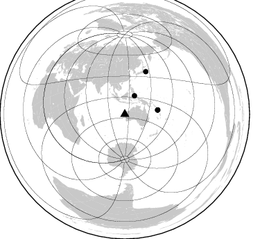
Azimuth Distribution of Events:
Prior Results for this Station
| Study | Thickness | Vp/Vs | Vp | Vs | Poissons Ratio | Extra |
| EARS | 30 km | 1.68 | 5.989 km/s | 3.565 km/s | 0.23 | |
| Crust2.0 | 32 km | 1.81 | 5.989 km/s | 3.317 km/s | 0.28 | C4,continental shelf, 3.5 km seds. |
| Global Maxima | 30 km | 1.68 | 5.989 km/s | 3.565 km/s | 0.23 | amp=0.114656955 |
| Local Maxima 1 | 30 km | 1.70 | 5.989 km/s | 3.523 km/s | 0.24 | amp=0.05682617 |
| Local Maxima 2 | 28 km | 1.71 | 5.989 km/s | 3.513 km/s | 0.24 | amp=0.033501074 |
| Local Maxima 3 | 70 km | 2.05 | 5.989 km/s | 2.929 km/s | 0.34 | amp=0.020554833 |
| Local Maxima 4 | 64 km | 2.10 | 5.989 km/s | 2.855 km/s | 0.35 | amp=0.018017586 |
| Predicted Arrivals for vertical incidence (zero ray parameter) | |
| Ps | 3.35 SECOND |
| PpPs | 13.20 SECOND |
| PsPs/PpSs | 16.55 SECOND |
Events Processed for this Station
Download zip of receiver functions as SAC
Plot maxima for each earthquake.
Events Used in the Stack
(4 events)| Radial Match | Distance | Baz | FERegion | Time | Lat/Lon | Depth | Magnitude |
| 95.26781 | 47.8 deg | 82.665 deg | Solomon Islands | 2014/04/12 20:14:39 GMT | (-11.3, 162.2) | 29 km | 7.6 MWW, 8.3 MI |
| 94.10107 | 30.0 deg | 27.612 deg | Northern Molucca Sea | 2014/11/21 10:10:19 GMT | (2.3, 127.1) | 38 km | 6.5 MWC, 6.8 MI, 6.9 MI |
| 93.40924 | 47.7 deg | 82.758 deg | Solomon Islands | 2014/04/13 12:36:18 GMT | (-11.5, 162.1) | 35 km | 7.4 MWW, 7.7 MI |
| 85.04026 | 68.3 deg | 26.296 deg | Off East Coast Of Honshu, Japan | 2013/10/25 17:10:19 GMT | (37.2, 144.7) | 35 km | 7.1 MWW, 7.1 MWW, 7.1 MWB, 7.1 MWC, 7.2 MWC, 7.5 MI |
Losers
(15 events)| Radial Match | Distance | Baz | FERegion | Time | Lat/Lon | Depth | Magnitude | Reason |
| 79.72989 | 63.1 deg | 100.367 deg | Fiji Islands Region | 2014/11/01 18:57:22 GMT | (-19.7, -177.7) | 434 km | 7.1 MWW, 6.9 MI, 7.1 MWC, 7.2 MWB | |
| 77.99377 | 51.4 deg | 85.749 deg | Santa Cruz Islands | 2014/03/27 03:49:46 GMT | (-12.1, 166.5) | 112 km | 5.7 MB, 6.0 MWB, 6.0 MWW, 6.0 MWC | |
| 76.19663 | 46.0 deg | 39.69 deg | South Of Mariana Islands | 2013/10/06 16:38:08 GMT | (12.3, 141.7) | 104 km | 6.0 MWW, 6.0 MWB, 6.0 MWW, 6.1 MWC | |
| 74.73188 | 47.8 deg | 82.619 deg | Solomon Islands | 2014/04/12 20:24:46 GMT | (-11.3, 162.2) | 27 km | 5.9 MB | |
| 70.72528 | 38.7 deg | 66.6 deg | New Britain Region, P.N.G. | 2013/11/03 02:42:54 GMT | (-5.9, 148.9) | 89 km | 5.8 MWW, 5.7 MWB, 5.8 MWW, 5.9 MWC | |
| 65.52431 | 51.2 deg | 87.639 deg | Vanuatu Islands | 2014/06/19 10:17:58 GMT | (-13.6, 166.8) | 60 km | 6.4 MWP | |
| 64.03654 | 51.9 deg | 336.329 deg | Myanmar-India Border Region | 2014/11/20 18:14:37 GMT | (23.5, 93.5) | 48 km | 5.6 MWB | |
| 61.404606 | 46.9 deg | 155.152 deg | Balleny Islands Region | 2014/04/18 19:05:05 GMT | (-62.7, 155.5) | 10 km | 5.6 MB | |
| 61.10331 | 58.2 deg | 26.2 deg | Bonin Islands, Japan Region | 2014/06/30 19:55:32 GMT | (28.4, 138.9) | 512 km | 6.2 MWB | |
| 60.59358 | 61.3 deg | 109.411 deg | Kermadec Islands Region | 2014/03/19 16:00:23 GMT | (-27.9, -177.2) | 34 km | 5.7 MWB, 5.8 MWC, 5.8 MWW | |
| 59.68986 | 52.6 deg | 100.426 deg | Southeast Of Loyalty Islands | 2014/11/10 10:04:21 GMT | (-22.8, 171.4) | 10 km | 6.1 MWP | |
| 59.548054 | 30.8 deg | 19.1 deg | Celebes Sea | 2013/11/03 11:03:38 GMT | (4.7, 123.3) | 532 km | 5.9 MWW, 5.9 MWW, 6.0 MWB, 6.0 MWC | |
| 57.3758 | 55.5 deg | 19.14 deg | Southeast Of Ryukyu Islands | 2014/03/26 08:49:41 GMT | (28.2, 131.5) | 10 km | 5.6 MWP, 1.0 MI, 5.4 MWC, 5.5 MWW | |
| 55.74592 | 65.6 deg | 228.454 deg | Prince Edward Islands Region | 2014/11/17 16:52:46 GMT | (-46.4, 33.8) | 10 km | 6.2 MWB | |
| 50.738483 | 63.3 deg | 98.841 deg | Fiji Islands Region | 2014/05/09 14:03:59 GMT | (-18.4, -178.1) | 528 km | 5.6 MB |

