
Station S1 AUBUS - Georgiana Molloy Anglican School
Network: S1 - Australian Seismometers in Schools
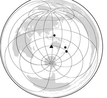
Nearby stations (2 deg radius)
| Station | Name | (Lat, Lon) | Start / End | Elevation |
| AUBUS | Georgiana Molloy Anglican School | (-33.66, 115.38) | 2013-10-20 / 2599-12-31 | 13 m |
| Crust2 Type: | TD,thick Margin /shield transition, East Siberia, 3.5 km seds. |
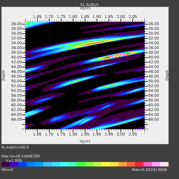
| Thickness Estimate: | 39 km |
| Thickness StdDev: | 8.6 km |
| Vp/Vs Estimate: | 1.99 |
| Vp/Vs StdDev: | 0.16 |
| Vs Estimate: | 3.181 km/s |
| Poisson's Ratio: | 0.33 |
| Peak Value: | 0.04 |
| Assumed Vp: | 6.314 km/s |
| Ps Weight: | 0.33333334 |
| PpPs Weight: | 0.33333334 |
| PsPs Weight: | 0.33333328 |
| Residual Complexity: | 0.833 |
| Nearby stations H: | 35 km +- 14 km |
| (2.0 deg) Vp/Vs: | 1.60 +- 0.00 |
0 with match > 90% ( 0.0 %) and 4 with match > 80% ( 3.960396 %) out of 101.
Download stack as xyz text file.
Azimuth Distribution of Events:
Prior Results for this Station
| Study | Thickness | Vp/Vs | Vp | Vs | Poissons Ratio | Extra |
| EARS | 39 km | 1.99 | 6.314 km/s | 3.181 km/s | 0.33 | |
| Crust2.0 | 35 km | 1.79 | 6.314 km/s | 3.523 km/s | 0.27 | TD,thick Margin /shield transition, East Siberia, 3.5 km seds. |
| Global Maxima | 39 km | 1.99 | 6.314 km/s | 3.181 km/s | 0.33 | amp=0.042414606 |
| Local Maxima 1 | 34 km | 1.89 | 6.314 km/s | 3.336 km/s | 0.31 | amp=0.033779684 |
| Local Maxima 2 | 25 km | 1.60 | 6.314 km/s | 3.946 km/s | 0.18 | amp=0.028292667 |
| Local Maxima 3 | 52 km | 1.95 | 6.314 km/s | 3.246 km/s | 0.32 | amp=0.023726804 |
| Local Maxima 4 | 50 km | 1.81 | 6.314 km/s | 3.498 km/s | 0.28 | amp=0.021433162 |
| Predicted Arrivals for vertical incidence (zero ray parameter) | |
| Ps | 6.08 SECOND |
| PpPs | 18.44 SECOND |
| PsPs/PpSs | 24.52 SECOND |
Events Processed for this Station
Download zip of receiver functions as SAC
Plot maxima for each earthquake.
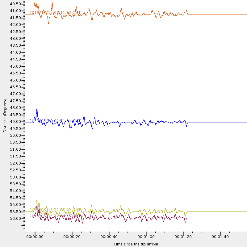
Events Used in the Stack
(4 events)| Radial Match | Distance | Baz | FERegion | Time | Lat/Lon | Depth | Magnitude |
| 86.8483 | 49.0 deg | 92.591 deg | Southeast Of Loyalty Islands | 2023/05/20 01:51:01 UTC | (-23.1, 170.4) | 45 km | 7.4 Mi |
| 83.472015 | 41.2 deg | 14.878 deg | Mindanao, Philippines | 2019/12/15 06:11:52 UTC | (6.7, 125.2) | 22 km | 6.8 mww |
| 81.650566 | 55.5 deg | 106.663 deg | Kermadec Islands, New Zealand | 2019/06/15 22:55:02 UTC | (-30.8, -178.1) | 35 km | 7.4 Mwp |
| 81.62662 | 55.9 deg | 107.165 deg | Kermadec Islands Region | 2019/06/15 22:54:55 UTC | (-31.0, -177.4) | 10 km | 7.4 Mi |
Losers
(97 events)| Radial Match | Distance | Baz | FERegion | Time | Lat/Lon | Depth | Magnitude | Reason |
| 92.74185 | 57.4 deg | 105.266 deg | Kermadec Islands Region | 2021/03/05 00:28:19 UTC | (-29.0, -176.6) | 10 km | 5.9 mb | |
| 90.012665 | 65.3 deg | 97.447 deg | Tonga Islands Region | 2022/11/11 10:48:45 UTC | (-19.3, -172.1) | 25 km | 7.3 Mww | |
| 88.33992 | 39.7 deg | 53.499 deg | Eastern New Guinea Reg., P.N.G. | 2022/09/10 23:46:55 UTC | (-6.2, 146.5) | 61 km | 7.6 mww | |
| 86.07565 | 50.3 deg | 93.331 deg | Southeast Of Loyalty Islands | 2021/03/04 14:10:36 UTC | (-23.1, 171.9) | 10 km | 5.6 mb | |
| 83.05059 | 75.1 deg | 21.253 deg | Near East Coast Of Honshu, Japan | 2022/03/16 14:36:33 UTC | (37.7, 141.6) | 63 km | 7.3 mww | |
| 83.00831 | 55.4 deg | 104.877 deg | Kermadec Islands, New Zealand | 2023/03/04 06:41:22 UTC | (-29.5, -178.8) | 206 km | 6.9 mww | |
| 82.9932 | 32.4 deg | 24.743 deg | Seram, Indonesia | 2019/09/25 23:46:46 UTC | (-3.4, 128.4) | 30 km | 6.5 Mww | |
| 79.98419 | 36.5 deg | 18.743 deg | Northern Molucca Sea | 2019/11/14 16:17:42 UTC | (1.5, 126.4) | 62 km | 7.4 Mi | |
| 78.661156 | 57.4 deg | 104.988 deg | Kermadec Islands Region | 2021/03/05 03:33:20 UTC | (-28.8, -176.6) | 10 km | 5.6 mb | |
| 77.547325 | 47.6 deg | 5.295 deg | Luzon, Philippines | 2022/03/13 21:05:52 UTC | (14.1, 119.4) | 33 km | 6.7 Mi | |
| 74.87119 | 49.2 deg | 92.832 deg | Southeast Of Loyalty Islands | 2023/05/19 02:57:07 UTC | (-23.2, 170.7) | 10 km | 7.7 Mi | |
| 74.531654 | 50.2 deg | 81.193 deg | Vanuatu Islands | 2021/08/18 10:10:05 UTC | (-14.9, 167.1) | 91 km | 6.8 mww | |
| 73.23356 | 39.0 deg | 47.668 deg | New Guinea, Papua New Guinea | 2023/04/02 18:04:12 UTC | (-4.3, 143.2) | 74 km | 7.3 Mi | |
| 70.71628 | 35.5 deg | 18.858 deg | Northern Molucca Sea | 2019/07/07 15:08:40 UTC | (0.5, 126.2) | 36 km | 6.9 Mww | |
| 69.89243 | 51.2 deg | 6.638 deg | Luzon, Philippines | 2022/07/27 00:43:24 UTC | (17.6, 120.8) | 10 km | 7.0 Mww | |
| 69.725174 | 38.7 deg | 18.23 deg | Talaud Islands, Indonesia | 2022/01/22 02:26:13 UTC | (3.7, 126.7) | 24 km | 6.0 mww | |
| 69.51544 | 53.8 deg | 92.406 deg | Vanuatu Islands Region | 2021/10/02 06:29:16 UTC | (-20.9, 174.9) | 486 km | 7.2 Mi | |
| 69.233734 | 41.4 deg | 14.894 deg | Mindanao, Philippines | 2019/10/29 01:04:46 UTC | (6.9, 125.2) | 50 km | 6.8 Mi | |
| 69.05571 | 31.1 deg | 33.585 deg | Tanimbar Islands Reg., Indonesia | 2023/02/17 09:37:34 UTC | (-6.6, 132.1) | 39 km | 6.1 Mww | |
| 68.7363 | 50.1 deg | 93.394 deg | Southeast Of Loyalty Islands | 2021/02/11 00:14:47 UTC | (-23.2, 171.7) | 10 km | 5.9 Mww | |
| 67.92059 | 61.9 deg | 229.077 deg | South Of Africa | 2020/09/26 17:10:22 UTC | (-48.1, 31.7) | 10 km | 6.2 mww | |
| 67.87144 | 50.2 deg | 83.161 deg | Vanuatu Islands | 2019/07/31 15:02:33 UTC | (-16.2, 167.9) | 179 km | 6.6 mww | |
| 67.489845 | 45.3 deg | 157.966 deg | Balleny Islands Region | 2022/02/21 23:24:13 UTC | (-69.8, 165.4) | 10 km | 6.6 mww | |
| 67.34183 | 55.9 deg | 105.848 deg | Kermadec Islands, New Zealand | 2023/04/24 00:41:54 UTC | (-30.0, -177.9) | 34 km | 7.3 mww | |
| 66.86771 | 30.1 deg | 19.5 deg | Banda Sea | 2022/01/04 20:55:47 UTC | (-4.8, 125.1) | 556 km | 6.0 mww | |
| 66.259186 | 47.4 deg | 7.077 deg | Mindoro, Philippines | 2021/07/23 20:48:57 UTC | (13.7, 120.7) | 110 km | 6.7 mww | |
| 66.11227 | 83.0 deg | 308.728 deg | Southern Iran | 2022/07/01 21:32:07 UTC | (26.9, 55.2) | 10 km | 6.1 mww | |
| 65.11999 | 62.9 deg | 98.41 deg | Tonga Islands | 2019/06/02 10:36:29 UTC | (-21.2, -173.9) | 10 km | 5.9 Mww | |
| 64.82443 | 56.8 deg | 105.48 deg | Kermadec Islands, New Zealand | 2021/03/04 21:04:06 UTC | (-29.4, -177.1) | 10 km | 5.8 mb | |
| 64.34549 | 62.3 deg | 99.141 deg | Tonga Islands Region | 2021/09/05 17:51:42 UTC | (-22.1, -174.2) | 10 km | 5.9 mww | |
| 63.94499 | 49.7 deg | 88.758 deg | Vanuatu Islands | 2019/11/23 02:33:12 UTC | (-20.2, 169.7) | 123 km | 5.3 Mww | |
| 63.889763 | 41.1 deg | 17.035 deg | Mindanao, Philippines | 2019/05/31 10:12:32 UTC | (6.3, 126.6) | 90 km | 6.1 Mww | |
| 63.30217 | 56.9 deg | 105.677 deg | Kermadec Islands Region | 2021/04/06 08:16:15 UTC | (-29.5, -176.9) | 10 km | 5.7 Mww | |
| 62.839714 | 75.5 deg | 21.257 deg | Near East Coast Of Honshu, Japan | 2021/05/01 01:27:30 UTC | (38.1, 141.8) | 56 km | 6.6 Mi | |
| 62.74152 | 63.6 deg | 94.682 deg | Tonga Islands | 2022/06/04 13:07:25 UTC | (-18.0, -175.0) | 237 km | 6.3 mww | |
| 62.56758 | 41.1 deg | 16.51 deg | Mindanao, Philippines | 2022/12/09 20:01:55 UTC | (6.4, 126.2) | 68 km | 5.6 Mww | |
| 62.30325 | 57.9 deg | 12.041 deg | Southeast Of Ryukyu Islands | 2021/11/10 15:45:13 UTC | (23.5, 126.5) | 10 km | 6.6 Mww | |
| 62.093853 | 80.9 deg | 199.136 deg | South Sandwich Islands Region | 2021/08/22 00:45:08 UTC | (-60.1, -24.3) | 11 km | 6.8 mww | |
| 61.31674 | 39.4 deg | 20.293 deg | North Of Halmahera, Indonesia | 2021/12/04 23:47:57 UTC | (4.1, 128.1) | 174 km | 6.0 mww | |
| 61.110424 | 40.5 deg | 17.246 deg | Mindanao, Philippines | 2019/09/29 02:02:52 UTC | (5.7, 126.5) | 76 km | 6.2 Mww | |
| 61.071957 | 42.0 deg | 14.3 deg | Mindanao, Philippines | 2019/11/18 13:22:12 UTC | (7.6, 125.0) | 26 km | 5.9 Mww | |
| 60.94936 | 46.9 deg | 60.954 deg | Solomon Islands | 2019/07/11 17:08:37 UTC | (-4.7, 155.2) | 496 km | 6.0 Mww | |
| 60.92361 | 82.9 deg | 308.723 deg | Southern Iran | 2022/07/01 23:25:15 UTC | (26.9, 55.3) | 10 km | 6.0 Mwb | |
| 60.794662 | 38.7 deg | 28.537 deg | Irian Jaya Region, Indonesia | 2019/11/23 12:11:16 UTC | (1.6, 132.8) | 10 km | 6.1 Mww | |
| 60.47949 | 54.9 deg | 98.828 deg | South Of Fiji Islands | 2023/04/28 03:13:43 UTC | (-25.1, 178.5) | 577 km | 6.2 mb | |
| 59.815266 | 59.9 deg | 92.494 deg | Fiji Islands Region | 2021/12/26 15:42:56 UTC | (-18.1, -179.4) | 627 km | 6.1 mww | |
| 59.61442 | 53.3 deg | 92.53 deg | Vanuatu Islands Region | 2021/10/09 10:58:30 UTC | (-21.2, 174.5) | 520 km | 6.9 mww | |
| 59.580853 | 39.4 deg | 53.344 deg | Eastern New Guinea Reg., P.N.G. | 2023/02/04 12:22:36 UTC | (-6.4, 146.2) | 102 km | 5.7 mww | |
| 59.2981 | 87.2 deg | 182.233 deg | Drake Passage | 2020/02/07 18:52:50 UTC | (-59.4, -60.3) | 10 km | 5.5 Mww | |
| 58.504852 | 82.0 deg | 200.548 deg | South Sandwich Islands Region | 2021/08/16 11:10:35 UTC | (-58.4, -23.3) | 10 km | 6.9 Mww | |
| 57.624786 | 42.8 deg | 55.49 deg | Bismarck Sea | 2023/03/01 05:36:14 UTC | (-4.8, 149.6) | 583 km | 6.5 Mi | |
| 57.493183 | 50.2 deg | 82.104 deg | Vanuatu Islands | 2019/07/01 17:13:29 UTC | (-15.5, 167.5) | 100 km | 6.0 Mww | |
| 56.93229 | 51.5 deg | 6.382 deg | Luzon, Philippines | 2022/10/25 14:59:04 UTC | (17.9, 120.6) | 10 km | 6.8 Mi | |
| 56.794937 | 33.3 deg | 11.984 deg | Minahassa Peninsula, Sulawesi | 2021/07/26 12:09:06 UTC | (-0.7, 121.9) | 11 km | 6.2 mww | |
| 56.757786 | 63.2 deg | 94.984 deg | Tonga Islands | 2019/11/04 22:43:37 UTC | (-18.4, -175.2) | 10 km | 6.9 Mi | |
| 56.58471 | 82.2 deg | 199.467 deg | South Sandwich Islands Region | 2022/09/10 11:14:32 UTC | (-58.8, -25.3) | 10 km | 5.4 Mww | |
| 56.13814 | 50.5 deg | 93.181 deg | Southeast Of Loyalty Islands | 2022/05/26 15:38:03 UTC | (-22.9, 172.0) | 10 km | 6.9 Mi | |
| 55.79776 | 62.8 deg | 98.265 deg | Tonga Islands | 2019/06/15 21:56:09 UTC | (-21.1, -174.0) | 10 km | 6.1 Mww | |
| 55.652092 | 49.6 deg | 90.188 deg | Southeast Of Loyalty Islands | 2022/09/14 11:04:07 UTC | (-21.2, 170.1) | 124 km | 7.0 Mi | |
| 55.60043 | 79.2 deg | 200.657 deg | East Of South Sandwich Islands | 2022/09/29 03:03:29 UTC | (-60.6, -20.0) | 33 km | 6.7 Mi | |
| 55.123276 | 56.7 deg | 97.302 deg | South Of Fiji Islands | 2021/07/07 06:39:08 UTC | (-23.2, 179.6) | 536 km | 5.7 mww | |
| 54.5984 | 58.1 deg | 96.342 deg | Fiji Islands Region | 2021/07/02 20:14:38 UTC | (-21.8, -179.4) | 606 km | 6.1 Mww | |
| 53.73154 | 52.7 deg | 7.042 deg | Philippine Islands Region | 2022/06/30 18:40:38 UTC | (19.1, 121.3) | 36 km | 5.9 Mww | |
| 53.70434 | 60.1 deg | 97.325 deg | Fiji Islands Region | 2021/04/25 22:28:00 UTC | (-21.7, -177.1) | 234 km | 6.4 Mww | |
| 53.266228 | 33.3 deg | 29.094 deg | Seram, Indonesia | 2022/01/19 14:29:43 UTC | (-3.5, 130.9) | 9.3 km | 5.3 Mww | |
| 53.03379 | 61.1 deg | 94.21 deg | Fiji Islands Region | 2021/05/07 23:35:14 UTC | (-18.8, -177.5) | 384 km | 6.1 Mww | |
| 51.854996 | 50.5 deg | 80.624 deg | Vanuatu Islands | 2019/08/24 15:51:27 UTC | (-14.3, 167.2) | 115 km | 6.0 Mww | |
| 50.678547 | 97.1 deg | 311.762 deg | Turkey-Iran Border Region | 2023/03/24 03:16:57 UTC | (38.5, 44.8) | 18 km | 5.6 mww | |
| 50.678013 | 47.2 deg | 67.594 deg | Solomon Islands | 2019/05/27 09:25:20 UTC | (-8.2, 158.6) | 117 km | 5.5 mb | |
| 50.467636 | 54.5 deg | 99.737 deg | South Of Fiji Islands | 2022/11/09 09:38:42 UTC | (-26.0, 178.4) | 629 km | 6.8 mww | |
| 50.278877 | 69.6 deg | 98.193 deg | Tonga Islands Region | 2021/02/16 00:49:28 UTC | (-17.8, -167.8) | 14 km | 6.7 Mi | |
| 50.155052 | 61.1 deg | 98.69 deg | Tonga Islands Region | 2020/06/05 06:19:38 UTC | (-22.3, -175.5) | 41 km | 5.3 Mww | |
| 49.93317 | 49.0 deg | 92.904 deg | Southeast Of Loyalty Islands | 2023/05/19 03:10:44 UTC | (-23.3, 170.4) | 19 km | 5.7 mb | |
| 49.792683 | 49.9 deg | 80.93 deg | Vanuatu Islands | 2023/01/11 08:39:53 UTC | (-14.9, 166.7) | 10 km | 5.8 Mww | |
| 49.604984 | 57.9 deg | 96.424 deg | Fiji Islands Region | 2019/11/08 10:44:44 UTC | (-22.0, -179.5) | 583 km | 6.5 Mww | |
| 49.49747 | 77.1 deg | 207.204 deg | East Of South Sandwich Islands | 2021/04/03 01:16:39 UTC | (-58.0, -7.9) | 10 km | 6.4 Mwp | |
| 49.075535 | 40.3 deg | 15.285 deg | Mindanao, Philippines | 2021/08/27 10:22:26 UTC | (5.7, 125.2) | 39 km | 5.6 Mww | |
| 48.974007 | 74.9 deg | 21.168 deg | Near East Coast Of Honshu, Japan | 2021/02/15 12:26:18 UTC | (37.5, 141.4) | 40 km | 5.3 Mww | |
| 47.96011 | 49.8 deg | 92.739 deg | Southeast Of Loyalty Islands | 2021/02/11 08:22:10 UTC | (-22.9, 171.2) | 10 km | 5.9 mww | |
| 46.501537 | 56.1 deg | 99.366 deg | South Of Fiji Islands | 2022/01/10 20:03:03 UTC | (-25.0, 179.9) | 489 km | 5.7 Mww | |
| 46.401108 | 48.1 deg | 13.304 deg | Philippine Islands Region | 2023/04/04 12:54:32 UTC | (13.8, 125.5) | 15 km | 6.2 mww | |
| 46.016487 | 97.0 deg | 311.88 deg | Armenia-Azerbaijan-Iran Bord Reg | 2022/10/05 00:21:29 UTC | (38.5, 45.0) | 15 km | 5.6 mww | |
| 45.751305 | 73.7 deg | 18.009 deg | Near West Coast Of Honshu, Japan | 2023/05/05 05:42:04 UTC | (37.5, 137.3) | 8.7 km | 6.2 mww | |
| 45.243965 | 34.3 deg | 331.633 deg | Southern Sumatra, Indonesia | 2019/10/22 22:11:06 UTC | (-2.4, 99.8) | 12 km | 5.1 Mww | |
| 44.851482 | 38.0 deg | 144.605 deg | Macquarie Island Region | 2021/10/07 20:13:01 UTC | (-58.8, 158.6) | 10 km | 5.9 mwb | |
| 44.286537 | 66.4 deg | 22.788 deg | Southeast Of Honshu, Japan | 2019/06/04 04:39:17 UTC | (29.1, 139.3) | 430 km | 6.3 Mww | |
| 43.57033 | 55.4 deg | 106.959 deg | Kermadec Islands Region | 2019/06/16 05:17:16 UTC | (-31.1, -178.0) | 35 km | 6.3 Mww | |
| 43.38833 | 54.9 deg | 295.215 deg | Carlsberg Ridge | 2019/07/02 09:44:33 UTC | (-1.5, 67.6) | 10 km | 5.8 Mww | |
| 43.105442 | 32.7 deg | 26.828 deg | Seram, Indonesia | 2021/06/16 04:43:07 UTC | (-3.6, 129.5) | 5.7 km | 5.9 Mww | |
| 41.08169 | 86.4 deg | 24.679 deg | Kuril Islands | 2021/09/20 20:25:25 UTC | (46.4, 152.4) | 25 km | 6.0 mww | |
| 39.47841 | 83.0 deg | 309.813 deg | Southern Iran | 2021/11/14 12:07:03 UTC | (27.7, 56.1) | 7.0 km | 6.0 Mwb | |
| 39.00035 | 77.2 deg | 150.102 deg | Southern East Pacific Rise | 2022/09/04 23:57:32 UTC | (-56.0, -124.5) | 10 km | 6.1 mww | |
| 38.481163 | 59.1 deg | 95.739 deg | Fiji Islands Region | 2022/10/14 10:05:17 UTC | (-20.9, -178.7) | 566 km | 5.5 Mww | |
| 38.468605 | 83.0 deg | 309.831 deg | Southern Iran | 2021/11/14 12:08:38 UTC | (27.7, 56.1) | 10 km | 6.3 mb | |
| 35.050846 | 33.3 deg | 331.68 deg | Southern Sumatra, Indonesia | 2020/10/19 07:31:28 UTC | (-3.4, 100.3) | 10 km | 5.6 Mww | |
| 33.36914 | 82.7 deg | 310.849 deg | Southern Iran | 2020/03/27 06:40:42 UTC | (28.3, 57.1) | 10 km | 5.3 Mww | |
| 30.961845 | 57.2 deg | 104.688 deg | Kermadec Islands Region | 2021/03/06 07:16:19 UTC | (-28.6, -177.0) | 10 km | 5.6 mb |

