
Station S1 AUCAR - St Mary Star of the Sea
Network: S1 - Australian Seismometers in Schools
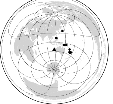
Nearby stations (2 deg radius)
| Station | Name | (Lat, Lon) | Start / End | Elevation |
| AUCAR | St Mary Star of the Sea | (-24.89, 113.66) | 2013-09-10 / 2499-01-01 | 17 m |
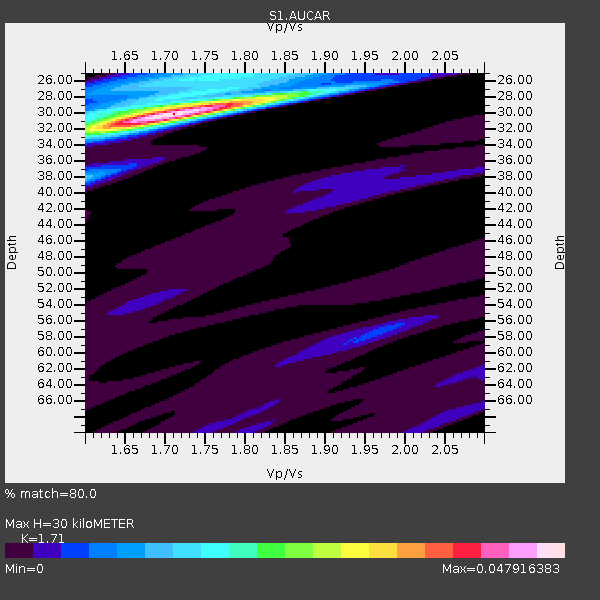
| Crust2 Type: | C4,continental shelf, 3.5 km seds. |
| Thickness Estimate: | 30 km |
| Thickness StdDev: | 0.8 km |
| Vp/Vs Estimate: | 1.71 |
| Vp/Vs StdDev: | 0.02 |
| Vs Estimate: | 3.502 km/s |
| Poisson's Ratio: | 0.24 |
| Peak Value: | 0.05 |
| Assumed Vp: | 5.989 km/s |
| Ps Weight: | 0.33333334 |
| PpPs Weight: | 0.33333334 |
| PsPs Weight: | 0.33333328 |
| Residual Complexity: | 0.382 |
| Nearby stations H: | 30 km +- 0.0 km |
| (2.0 deg) Vp/Vs: | 1.69 +- 0.01 |
2 with match > 90% ( 3.8461537 %) and 10 with match > 80% ( 19.23077 %) out of 52.
Download stack as xyz text file.
Azimuth Distribution of Events:
Prior Results for this Station
| Study | Thickness | Vp/Vs | Vp | Vs | Poissons Ratio | Extra |
| EARS | 30 km | 1.71 | 5.989 km/s | 3.502 km/s | 0.24 | |
| Crust2.0 | 32 km | 1.81 | 5.989 km/s | 3.317 km/s | 0.28 | C4,continental shelf, 3.5 km seds. |
| Global Maxima | 30 km | 1.71 | 5.989 km/s | 3.502 km/s | 0.24 | amp=0.047916383 |
| Local Maxima 1 | 25 km | 1.74 | 5.989 km/s | 3.437 km/s | 0.25 | amp=0.014322529 |
| Local Maxima 2 | 28 km | 1.84 | 5.989 km/s | 3.251 km/s | 0.29 | amp=0.012896993 |
| Local Maxima 3 | 38 km | 1.60 | 5.989 km/s | 3.743 km/s | 0.18 | amp=0.012125296 |
| Local Maxima 4 | 32 km | 1.62 | 5.989 km/s | 3.686 km/s | 0.20 | amp=0.010711045 |
| Predicted Arrivals for vertical incidence (zero ray parameter) | |
| Ps | 3.56 SECOND |
| PpPs | 13.57 SECOND |
| PsPs/PpSs | 17.13 SECOND |
Events Processed for this Station
Download zip of receiver functions as SAC
Plot maxima for each earthquake.
Events Used in the Stack
(10 events)| Radial Match | Distance | Baz | FERegion | Time | Lat/Lon | Depth | Magnitude |
| 92.27907 | 36.5 deg | 64.945 deg | Eastern New Guinea Reg., P.N.G. | 2022/09/10 23:46:55 UTC | (-6.2, 146.5) | 61 km | 7.6 mww |
| 91.142 | 53.0 deg | 100.739 deg | Southeast Of Loyalty Islands | 2022/05/26 15:38:03 UTC | (-22.9, 172.0) | 10 km | 6.9 Mi |
| 88.00978 | 51.5 deg | 100.017 deg | Southeast Of Loyalty Islands | 2022/03/30 20:56:58 UTC | (-22.7, 170.3) | 10 km | 6.7 mww |
| 86.52542 | 50.9 deg | 89.326 deg | Vanuatu Islands | 2021/08/18 10:10:05 UTC | (-14.9, 167.1) | 91 km | 6.8 mww |
| 86.398926 | 51.8 deg | 98.099 deg | Southeast Of Loyalty Islands | 2022/09/14 11:04:07 UTC | (-21.2, 170.1) | 124 km | 7.0 Mi |
| 82.943 | 67.6 deg | 23.699 deg | Near East Coast Of Honshu, Japan | 2022/03/16 14:36:33 UTC | (37.7, 141.6) | 63 km | 7.3 mww |
| 82.93792 | 43.2 deg | 69.065 deg | New Ireland Region, P.N.G. | 2022/10/13 22:20:20 UTC | (-4.8, 153.6) | 71 km | 6.4 mww |
| 82.431 | 39.0 deg | 10.974 deg | Mindoro, Philippines | 2021/07/23 20:48:57 UTC | (13.7, 120.7) | 110 km | 6.7 mww |
| 81.79766 | 39.1 deg | 8.867 deg | Luzon, Philippines | 2022/03/13 21:05:52 UTC | (14.1, 119.4) | 33 km | 6.7 Mi |
| 80.42666 | 56.2 deg | 99.248 deg | Vanuatu Islands Region | 2021/10/02 06:29:16 UTC | (-20.9, 174.9) | 486 km | 7.2 Mi |
Losers
(42 events)| Radial Match | Distance | Baz | FERegion | Time | Lat/Lon | Depth | Magnitude | Reason |
| 84.09113 | 62.2 deg | 27.817 deg | Southeast Of Honshu, Japan | 2021/11/30 06:53:32 UTC | (31.2, 142.5) | 7.9 km | 5.5 mww | |
| 78.156494 | 31.1 deg | 25.796 deg | Talaud Islands, Indonesia | 2022/01/22 02:26:13 UTC | (3.7, 126.7) | 24 km | 6.0 mww | |
| 75.50413 | 32.7 deg | 50.263 deg | Irian Jaya, Indonesia | 2022/09/09 23:31:47 UTC | (-2.2, 138.2) | 18 km | 6.2 mww | |
| 75.014595 | 88.6 deg | 199.578 deg | South Sandwich Islands Region | 2021/08/22 00:45:08 UTC | (-60.1, -24.3) | 11 km | 6.8 mww | |
| 74.5847 | 32.0 deg | 28.042 deg | North Of Halmahera, Indonesia | 2021/12/04 23:47:57 UTC | (4.1, 128.1) | 174 km | 6.0 mww | |
| 72.805305 | 55.9 deg | 32.581 deg | Volcano Islands, Japan Region | 2022/05/01 21:57:48 UTC | (23.6, 142.7) | 51 km | 5.6 mww | |
| 69.13907 | 60.2 deg | 103.89 deg | South Of Fiji Islands | 2022/07/27 16:16:47 UTC | (-23.5, -179.7) | 545 km | 5.7 Mww | |
| 68.13913 | 30.3 deg | 26.058 deg | Northern Molucca Sea | 2021/07/10 00:43:56 UTC | (2.9, 126.5) | 45 km | 6.1 Mww | |
| 67.686325 | 50.8 deg | 92.774 deg | Vanuatu Islands | 2022/04/04 16:06:57 UTC | (-17.5, 167.9) | 33 km | 6.0 mww | |
| 66.7036 | 51.3 deg | 96.366 deg | Vanuatu Islands | 2022/07/22 11:31:47 UTC | (-20.0, 169.2) | 82 km | 5.5 Mww | |
| 65.95862 | 59.9 deg | 17.875 deg | Shikoku, Japan | 2022/01/21 16:08:37 UTC | (32.8, 132.0) | 42 km | 6.3 Mww | |
| 65.370384 | 38.6 deg | 66.208 deg | New Britain Region, P.N.G. | 2022/09/02 22:39:51 UTC | (-5.7, 148.7) | 126 km | 6.1 Mww | |
| 65.04215 | 88.6 deg | 199.256 deg | South Sandwich Islands Region | 2021/08/22 21:33:20 UTC | (-60.3, -24.9) | 14 km | 7.1 mww | |
| 65.01233 | 65.1 deg | 23.593 deg | Near East Coast Of Honshu, Japan | 2021/10/07 13:41:24 UTC | (35.6, 140.1) | 62 km | 5.9 mww | |
| 64.79183 | 51.5 deg | 99.571 deg | Southeast Of Loyalty Islands | 2022/03/31 03:06:47 UTC | (-22.4, 170.1) | 10 km | 5.7 mww | |
| 64.03828 | 76.2 deg | 309.596 deg | Southern Iran | 2021/11/14 12:07:03 UTC | (27.7, 56.1) | 7.0 km | 6.0 Mwb | |
| 63.76481 | 66.1 deg | 99.518 deg | Tonga Islands | 2022/06/04 13:07:25 UTC | (-18.0, -175.0) | 237 km | 6.3 mww | |
| 63.759415 | 65.5 deg | 104.039 deg | Tonga Islands Region | 2021/09/05 17:51:42 UTC | (-22.1, -174.2) | 10 km | 5.9 mww | |
| 63.4222 | 63.0 deg | 98.251 deg | Fiji Islands Region | 2021/12/17 20:02:28 UTC | (-17.9, -178.5) | 558 km | 5.7 Mww | |
| 62.385292 | 43.1 deg | 69.845 deg | New Ireland Region, P.N.G. | 2021/11/18 14:08:05 UTC | (-5.3, 153.7) | 35 km | 6.2 mww | |
| 61.32506 | 93.9 deg | 200.397 deg | South Sandwich Islands Region | 2022/01/25 01:24:33 UTC | (-55.4, -28.8) | 11 km | 6.0 mww | |
| 61.214863 | 61.0 deg | 102.124 deg | Fiji Islands Region | 2021/07/02 20:14:38 UTC | (-21.8, -179.4) | 606 km | 6.1 Mww | |
| 60.32853 | 75.2 deg | 326.578 deg | Afghanistan-Tajikistan Bord Reg. | 2021/07/10 02:14:43 UTC | (39.0, 70.6) | 17 km | 5.8 Mww | |
| 60.17392 | 51.3 deg | 11.987 deg | Northeast Of Taiwan | 2022/03/18 19:04:18 UTC | (25.7, 124.0) | 167 km | 5.9 mww | |
| 59.917496 | 63.6 deg | 25.764 deg | Off East Coast Of Honshu, Japan | 2022/05/18 03:52:25 UTC | (33.3, 141.4) | 13 km | 5.6 mww | |
| 59.28199 | 62.3 deg | 28.16 deg | Southeast Of Honshu, Japan | 2021/11/29 12:40:43 UTC | (31.1, 142.8) | 10 km | 6.6 Mi | |
| 58.753975 | 43.4 deg | 72.058 deg | Solomon Islands | 2022/01/16 12:52:10 UTC | (-6.4, 154.8) | 408 km | 6.1 Mww | |
| 58.432053 | 44.3 deg | 10.376 deg | Philippine Islands Region | 2022/06/30 18:40:38 UTC | (19.1, 121.3) | 36 km | 5.9 Mww | |
| 56.64689 | 39.2 deg | 10.817 deg | Mindoro, Philippines | 2022/05/21 21:50:48 UTC | (14.0, 120.7) | 136 km | 6.1 mww | |
| 56.39443 | 33.2 deg | 24.114 deg | Mindanao, Philippines | 2022/02/20 18:29:28 UTC | (6.0, 126.7) | 72 km | 5.6 Mww | |
| 55.01612 | 62.2 deg | 98.094 deg | Fiji Islands Region | 2021/12/26 15:42:56 UTC | (-18.1, -179.4) | 627 km | 6.1 mww | |
| 54.908436 | 60.3 deg | 111.663 deg | Kermadec Islands, New Zealand | 2022/03/02 12:52:07 UTC | (-30.1, -177.7) | 24 km | 6.6 mww | |
| 54.848873 | 42.8 deg | 10.062 deg | Luzon, Philippines | 2022/07/27 00:43:24 UTC | (17.6, 120.8) | 10 km | 7.0 Mww | |
| 54.5694 | 57.9 deg | 106.365 deg | South Of Fiji Islands | 2022/05/22 07:06:27 UTC | (-26.2, 178.4) | 590 km | 6.3 mww | |
| 53.791622 | 60.2 deg | 111.795 deg | Kermadec Islands, New Zealand | 2021/06/20 17:05:48 UTC | (-30.2, -177.8) | 10 km | 6.5 mww | |
| 52.977776 | 59.5 deg | 114.786 deg | South Of Kermadec Islands | 2022/08/14 13:44:22 UTC | (-32.9, -178.0) | 33 km | 6.8 Mi | |
| 52.35336 | 58.7 deg | 114.365 deg | South Of Kermadec Islands | 2022/08/14 13:44:17 UTC | (-32.7, -179.0) | 10 km | 6.4 Mww | |
| 51.82087 | 62.7 deg | 104.362 deg | South Of Fiji Islands | 2021/08/17 17:24:47 UTC | (-23.2, -177.0) | 139 km | 5.8 Mww | |
| 48.666367 | 52.8 deg | 100.524 deg | Southeast Of Loyalty Islands | 2021/06/23 05:39:39 UTC | (-22.8, 171.7) | 10 km | 5.5 mb | |
| 48.05921 | 37.3 deg | 327.079 deg | Nicobar Islands, India Region | 2022/04/06 05:29:43 UTC | (7.4, 94.3) | 10 km | 5.5 Mww | |
| 47.598877 | 76.2 deg | 309.614 deg | Southern Iran | 2021/11/14 12:08:38 UTC | (27.7, 56.1) | 10 km | 6.3 mb | |
| 38.21989 | 32.7 deg | 50.285 deg | Irian Jaya, Indonesia | 2022/09/09 23:44:09 UTC | (-2.3, 138.2) | 15 km | 5.8 Mww |

