
Station S1 AUCSH - Cairns State High School
Network: S1 - Australian Seismometers in Schools
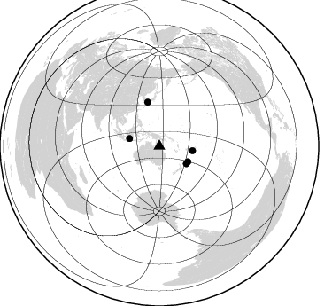
Nearby stations (2 deg radius)
| Station | Name | (Lat, Lon) | Start / End | Elevation |
| AUCSH | Cairns State High School | (-16.92, 145.77) | 2013-09-03 / 2499-01-01 | 17 m |
| Crust2 Type: | TH,Margin /shield transition, 0.5 km seds. |
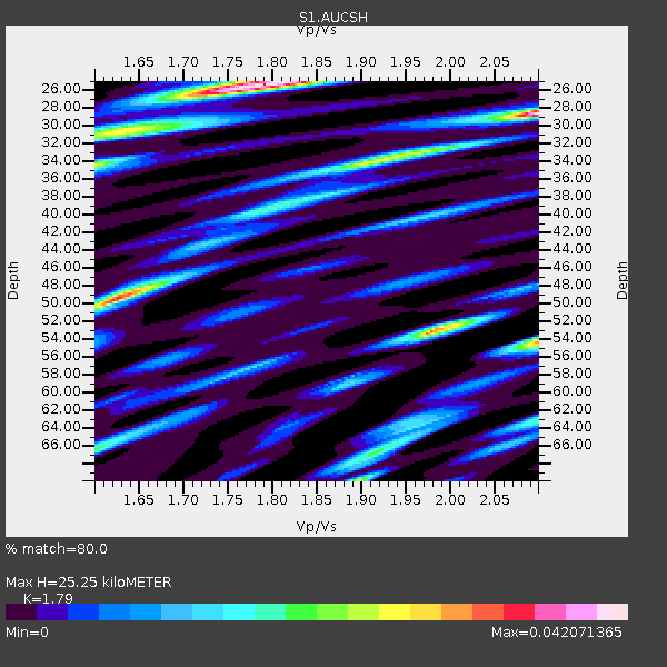
| Thickness Estimate: | 25 km |
| Thickness StdDev: | 15 km |
| Vp/Vs Estimate: | 1.79 |
| Vp/Vs StdDev: | 0.17 |
| Vs Estimate: | 3.657 km/s |
| Poisson's Ratio: | 0.27 |
| Peak Value: | 0.04 |
| Assumed Vp: | 6.545 km/s |
| Ps Weight: | 0.33333334 |
| PpPs Weight: | 0.33333334 |
| PsPs Weight: | 0.33333328 |
| Residual Complexity: | 0.813 |
| Nearby stations H: | 26 km +- 2.1 km |
| (2.0 deg) Vp/Vs: | 1.94 +- 0.23 |
0 with match > 90% ( 0.0 %) and 5 with match > 80% ( 10.869565 %) out of 46.
Download stack as xyz text file.
Azimuth Distribution of Events:
Prior Results for this Station
| Study | Thickness | Vp/Vs | Vp | Vs | Poissons Ratio | Extra |
| EARS | 25 km | 1.79 | 6.545 km/s | 3.657 km/s | 0.27 | |
| Crust2.0 | 32 km | 1.79 | 6.545 km/s | 3.666 km/s | 0.27 | TH,Margin /shield transition, 0.5 km seds. |
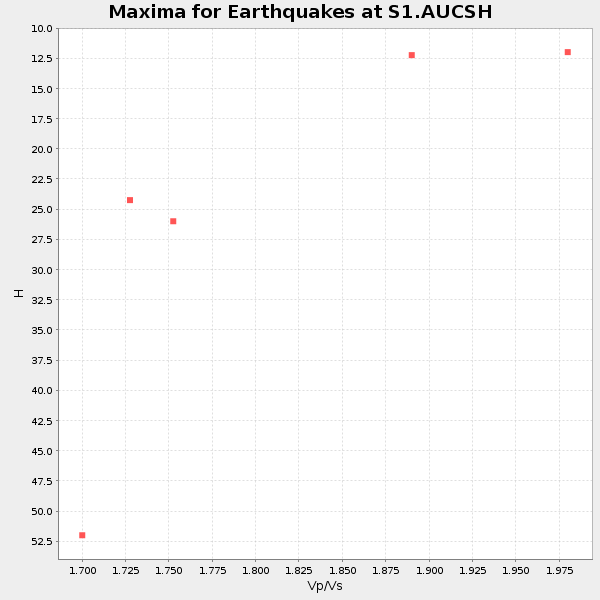
| Global Maxima | 25 km | 1.79 | 6.545 km/s | 3.657 km/s | 0.27 | amp=0.042071365 |
| Local Maxima 1 | 28 km | 2.10 | 6.545 km/s | 3.121 km/s | 0.35 | amp=0.041167825 |
| Local Maxima 2 | 53 km | 1.98 | 6.545 km/s | 3.31 km/s | 0.33 | amp=0.033107977 |
| Local Maxima 3 | 54 km | 2.10 | 6.545 km/s | 3.121 km/s | 0.35 | amp=0.030846607 |
| Local Maxima 4 | 49 km | 1.63 | 6.545 km/s | 4.022 km/s | 0.20 | amp=0.026685495 |
| Predicted Arrivals for vertical incidence (zero ray parameter) | |
| Ps | 3.05 SECOND |
| PpPs | 10.76 SECOND |
| PsPs/PpSs | 13.81 SECOND |
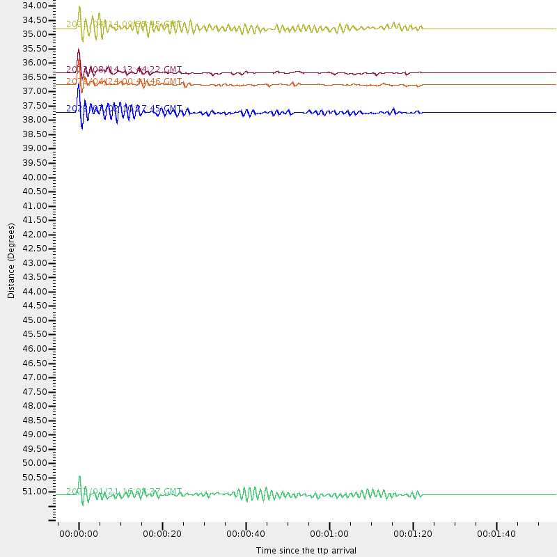
Events Processed for this Station
Download zip of receiver functions as SAC
Plot maxima for each earthquake.
Events Used in the Stack
(5 events)| Radial Match | Distance | Baz | FERegion | Time | Lat/Lon | Depth | Magnitude |
| 87.43824 | 36.7 deg | 118.364 deg | Kermadec Islands Region | 2023/04/24 00:41:46 UTC | (-30.4, -176.7) | 10 km | 7.3 Mi |
| 85.73741 | 34.7 deg | 284.161 deg | Java, Indonesia | 2023/04/14 09:55:45 UTC | (-6.0, 112.0) | 594 km | 7.0 mww |
| 83.87273 | 36.3 deg | 122.866 deg | South Of Kermadec Islands | 2022/08/14 13:44:22 UTC | (-32.9, -178.0) | 33 km | 6.8 Mi |
| 83.18879 | 37.7 deg | 97.525 deg | Tonga Islands | 2023/07/02 10:27:45 UTC | (-17.9, -174.7) | 247 km | 6.7 Mi |
| 82.32471 | 51.1 deg | 345.116 deg | Shikoku, Japan | 2022/01/21 16:08:37 UTC | (32.8, 132.0) | 42 km | 6.3 Mww |
Losers
(41 events)| Radial Match | Distance | Baz | FERegion | Time | Lat/Lon | Depth | Magnitude | Reason |
| 77.89444 | 35.8 deg | 118.143 deg | Kermadec Islands, New Zealand | 2022/03/02 12:52:07 UTC | (-30.1, -177.7) | 24 km | 6.6 mww | |
| 75.85132 | 37.4 deg | 97.6 deg | Tonga Islands | 2022/06/04 13:07:25 UTC | (-18.0, -175.0) | 237 km | 6.3 mww | |
| 75.74019 | 36.7 deg | 117.819 deg | Kermadec Islands Region | 2021/08/31 02:52:49 UTC | (-30.1, -176.6) | 40 km | 6.5 Mi | |
| 75.51561 | 32.6 deg | 110.478 deg | South Of Fiji Islands | 2021/10/21 08:10:43 UTC | (-25.2, 179.6) | 497 km | 6.0 mww | |
| 73.225464 | 33.2 deg | 104.102 deg | Fiji Islands Region | 2021/07/02 20:14:38 UTC | (-21.8, -179.4) | 606 km | 6.1 Mww | |
| 72.84532 | 33.2 deg | 97.293 deg | Fiji Islands Region | 2021/12/26 15:42:56 UTC | (-18.1, -179.4) | 627 km | 6.1 mww | |
| 71.21186 | 43.4 deg | 280.71 deg | Southern Sumatra, Indonesia | 2022/08/23 14:31:40 UTC | (-5.1, 103.1) | 59 km | 6.0 Mww | |
| 71.21183 | 35.7 deg | 118.396 deg | Kermadec Islands, New Zealand | 2021/06/20 17:05:48 UTC | (-30.2, -177.8) | 10 km | 6.5 mww | |
| 70.03958 | 36.4 deg | 117.194 deg | Kermadec Islands Region | 2022/01/29 04:59:10 UTC | (-29.7, -176.9) | 10 km | 5.8 mww | |
| 69.97527 | 35.5 deg | 106.358 deg | South Of Fiji Islands | 2021/08/17 17:24:47 UTC | (-23.2, -177.0) | 139 km | 5.8 Mww | |
| 69.66059 | 31.6 deg | 112.618 deg | South Of Fiji Islands | 2022/05/22 07:06:27 UTC | (-26.2, 178.4) | 590 km | 6.3 mww | |
| 68.704834 | 54.5 deg | 355.925 deg | Near East Coast Of Honshu, Japan | 2022/03/16 14:36:33 UTC | (37.7, 141.6) | 63 km | 7.3 mww | |
| 68.51205 | 34.3 deg | 139.295 deg | Cook Strait, New Zealand | 2023/02/15 06:38:09 UTC | (-40.5, 174.6) | 74 km | 5.7 mww | |
| 68.19003 | 31.5 deg | 110.451 deg | South Of Fiji Islands | 2023/04/28 03:51:06 UTC | (-25.1, 178.5) | 572 km | 5.5 mb | |
| 66.126816 | 31.5 deg | 110.529 deg | South Of Fiji Islands | 2023/04/28 03:13:43 UTC | (-25.1, 178.5) | 577 km | 6.2 mb | |
| 66.10252 | 74.4 deg | 22.244 deg | Andreanof Islands, Aleutian Is. | 2021/09/24 11:52:31 UTC | (51.1, -178.9) | 50 km | 6.3 Mi | |
| 65.96661 | 39.5 deg | 319.408 deg | Mindoro, Philippines | 2021/09/26 17:12:07 UTC | (13.9, 120.5) | 98 km | 5.7 mww | |
| 64.62833 | 49.5 deg | 286.197 deg | Northern Sumatra, Indonesia | 2023/04/03 14:59:42 UTC | (0.9, 98.8) | 85 km | 6.1 mww | |
| 63.395725 | 43.3 deg | 325.016 deg | Philippine Islands Region | 2023/03/22 23:31:55 UTC | (19.3, 121.2) | 30 km | 5.6 Mww | |
| 59.597477 | 39.6 deg | 92.914 deg | Samoa Islands Region | 2023/06/17 18:45:00 UTC | (-14.8, -173.0) | 10 km | 6.2 Mi | |
| 59.257416 | 44.0 deg | 169.965 deg | Macquarie Island Region | 2021/08/08 22:19:10 UTC | (-59.8, 159.6) | 10 km | 5.5 Mww | |
| 58.62602 | 66.8 deg | 2.847 deg | Sea Of Okhotsk | 2021/10/09 07:19:27 UTC | (50.0, 149.8) | 448 km | 5.6 Mww | |
| 58.49818 | 57.3 deg | 292.713 deg | Nicobar Islands, India Region | 2023/04/09 12:17:33 UTC | (9.0, 94.0) | 10 km | 5.6 Mww | |
| 58.33138 | 47.4 deg | 329.869 deg | Taiwan | 2021/10/24 05:11:34 UTC | (24.6, 121.8) | 65 km | 6.2 mww | |
| 57.87342 | 83.1 deg | 139.897 deg | Southern East Pacific Rise | 2022/05/26 18:10:04 UTC | (-49.8, -114.9) | 10 km | 6.2 Mww | |
| 57.53923 | 43.6 deg | 280.891 deg | Southern Sumatra, Indonesia | 2023/04/17 11:05:55 UTC | (-4.9, 103.0) | 58 km | 5.5 mb | |
| 57.52642 | 35.8 deg | 101.341 deg | Fiji Islands Region | 2023/03/24 13:01:34 UTC | (-20.3, -176.6) | 281 km | 5.6 Mww | |
| 57.499035 | 62.8 deg | 6.074 deg | East Of Kuril Islands | 2021/09/29 08:37:05 UTC | (45.8, 153.5) | 401 km | 6.5 Mi | |
| 57.43278 | 62.0 deg | 236.888 deg | Mid-Indian Ridge | 2022/09/19 17:53:45 UTC | (-36.9, 78.6) | 10 km | 5.6 Mww | |
| 57.121174 | 35.4 deg | 123.045 deg | South Of Kermadec Islands | 2022/08/29 18:10:50 UTC | (-32.7, -179.1) | 32 km | 5.8 mww | |
| 54.950798 | 74.3 deg | 20.171 deg | Rat Islands, Aleutian Islands | 2022/06/04 23:38:12 UTC | (52.1, 178.3) | 105 km | 6.3 mww | |
| 53.558155 | 47.2 deg | 336.354 deg | Ryukyu Islands, Japan | 2022/06/19 09:55:19 UTC | (26.7, 126.6) | 7.0 km | 5.5 mww | |
| 53.0746 | 46.4 deg | 328.048 deg | Taiwan | 2022/09/17 13:41:21 UTC | (23.0, 121.2) | 45 km | 6.6 Mi | |
| 53.062088 | 33.5 deg | 137.536 deg | North Island, New Zealand | 2022/01/12 10:49:35 UTC | (-39.3, 174.5) | 191 km | 5.7 mww | |
| 52.540222 | 83.4 deg | 232.966 deg | South Indian Ocean | 2021/11/15 04:23:30 UTC | (-37.5, 51.3) | 10 km | 6.0 mww | |
| 48.977768 | 44.8 deg | 169.831 deg | Macquarie Island Region | 2023/06/09 21:21:42 UTC | (-60.5, 160.3) | 9.8 km | 5.9 mww | |
| 46.5716 | 86.7 deg | 29.303 deg | South Of Alaska | 2021/07/29 06:32:30 UTC | (54.9, -156.4) | 10 km | 5.8 mb | |
| 45.94915 | 48.1 deg | 286.065 deg | Northern Sumatra, Indonesia | 2022/02/25 01:39:27 UTC | (0.2, 100.1) | 12 km | 6.2 mww | |
| 44.715626 | 73.4 deg | 319.578 deg | Qinghai, China | 2021/06/16 08:48:58 UTC | (38.2, 93.7) | 10 km | 5.4 Mww | |
| 43.901917 | 62.3 deg | 236.45 deg | Mid-Indian Ridge | 2021/06/15 23:50:04 UTC | (-37.3, 78.1) | 10 km | 5.5 mww | |
| 27.043114 | 39.1 deg | 319.332 deg | Mindoro, Philippines | 2021/12/13 09:12:35 UTC | (13.6, 120.7) | 157 km | 5.5 Mww |

