
Station S1 AUHPC - Hawkesdale P12 School
Network: S1 - Australian Seismometers in Schools
Nearby stations (2 deg radius)
| Station | Name | (Lat, Lon) | Start / End | Elevation |
| AUHPC | Hawkesdale P12 School | (-38.11, 142.32) | 2013-05-24 / 2599-12-31 | 11 m |
| Crust2 Type: | T4,Margin /shield transition, East Siberia, 2 km seds. |
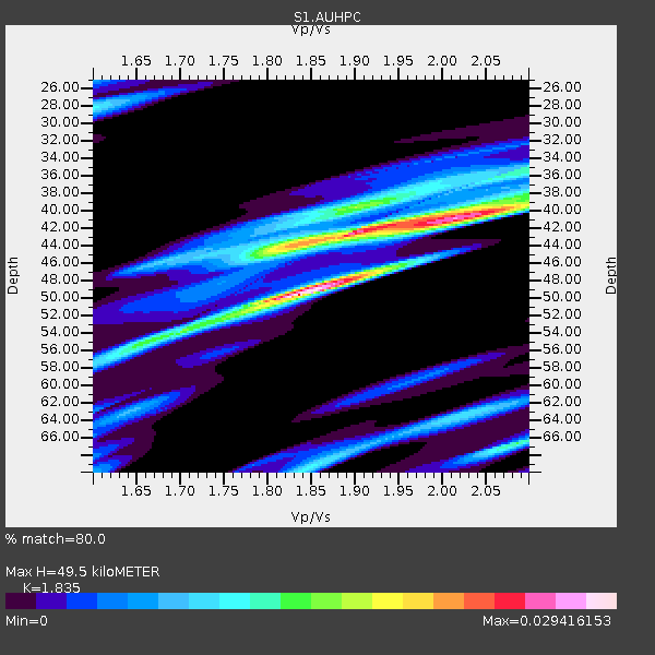
| Thickness Estimate: | 50 km |
| Thickness StdDev: | 7.6 km |
| Vp/Vs Estimate: | 1.84 |
| Vp/Vs StdDev: | 0.14 |
| Vs Estimate: | 3.483 km/s |
| Poisson's Ratio: | 0.29 |
| Peak Value: | 0.03 |
| Assumed Vp: | 6.391 km/s |
| Ps Weight: | 0.33333334 |
| PpPs Weight: | 0.33333334 |
| PsPs Weight: | 0.33333328 |
| Residual Complexity: | 0.804 |
| Nearby stations H: | 42 km +- 0.7 km |
| (2.0 deg) Vp/Vs: | 1.98 +- 0.01 |
0 with match > 90% ( 0.0 %) and 6 with match > 80% ( 16.216217 %) out of 37.
Download stack as xyz text file.
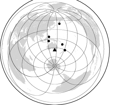
Azimuth Distribution of Events:
Prior Results for this Station
| Study | Thickness | Vp/Vs | Vp | Vs | Poissons Ratio | Extra |
| EARS | 50 km | 1.84 | 6.391 km/s | 3.483 km/s | 0.29 | |
| Crust2.0 | 32 km | 1.79 | 6.391 km/s | 3.572 km/s | 0.27 | T4,Margin /shield transition, East Siberia, 2 km seds. |
| Global Maxima | 50 km | 1.84 | 6.391 km/s | 3.483 km/s | 0.29 | amp=0.029416153 |
| Local Maxima 1 | 42 km | 1.89 | 6.391 km/s | 3.377 km/s | 0.31 | amp=0.024098437 |
| Local Maxima 2 | 40 km | 2.05 | 6.391 km/s | 3.114 km/s | 0.34 | amp=0.015067713 |
| Local Maxima 3 | 40 km | 1.90 | 6.391 km/s | 3.368 km/s | 0.31 | amp=0.013631475 |
| Local Maxima 4 | 66 km | 2.09 | 6.391 km/s | 3.065 km/s | 0.35 | amp=0.013261562 |
| Predicted Arrivals for vertical incidence (zero ray parameter) | |
| Ps | 6.47 SECOND |
| PpPs | 21.96 SECOND |
| PsPs/PpSs | 28.43 SECOND |
Events Processed for this Station
Download zip of receiver functions as SAC
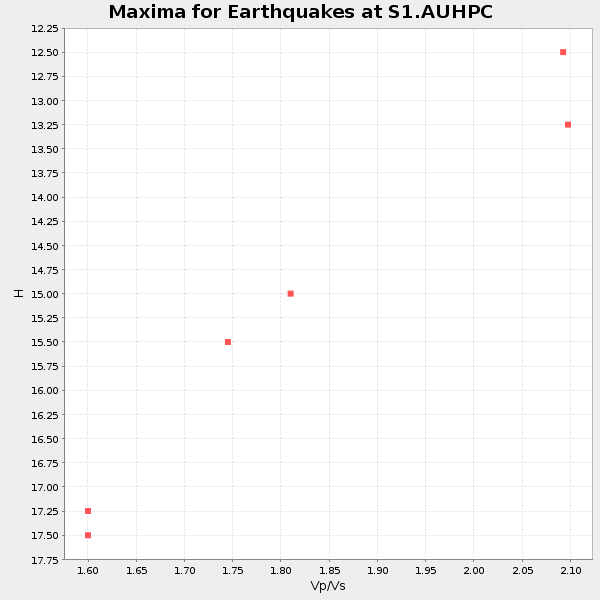
Plot maxima for each earthquake.
Events Used in the Stack
(6 events)| Radial Match | Distance | Baz | FERegion | Time | Lat/Lon | Depth | Magnitude |
| 87.51337 | 47.4 deg | 336.564 deg | Mindanao, Philippines | 2019/12/15 06:11:52 UTC | (6.7, 125.2) | 22 km | 6.8 mww |
| 86.00709 | 87.8 deg | 10.066 deg | East Of Kuril Islands | 2020/03/25 02:49:21 UTC | (49.0, 157.7) | 57 km | 7.5 Mww |
| 84.55361 | 31.4 deg | 52.911 deg | Vanuatu Islands | 2019/07/31 15:02:33 UTC | (-16.2, 167.9) | 179 km | 6.6 mww |
| 81.49032 | 33.7 deg | 90.228 deg | Kermadec Islands Region | 2019/06/15 22:54:55 UTC | (-31.0, -177.4) | 10 km | 7.4 Mi |
| 81.3613 | 33.3 deg | 89.455 deg | Kermadec Islands, New Zealand | 2019/06/15 22:55:02 UTC | (-30.8, -178.1) | 35 km | 7.4 Mwp |
| 80.141685 | 35.6 deg | 326.636 deg | Banda Sea | 2020/08/21 04:09:52 UTC | (-6.7, 123.5) | 627 km | 6.9 mww |
Losers
(31 events)| Radial Match | Distance | Baz | FERegion | Time | Lat/Lon | Depth | Magnitude | Reason |
| 88.71823 | 35.1 deg | 17.965 deg | New Britain Region, P.N.G. | 2019/05/14 12:58:26 UTC | (-4.1, 152.6) | 10 km | 7.5 Mww | |
| 85.79023 | 41.2 deg | 335.08 deg | Northern Molucca Sea | 2019/07/07 15:08:40 UTC | (0.5, 126.2) | 36 km | 6.9 Mww | |
| 84.51572 | 42.1 deg | 335.844 deg | Northern Molucca Sea | 2019/11/14 16:17:42 UTC | (1.5, 126.4) | 62 km | 7.4 Mi | |
| 82.86575 | 30.5 deg | 10.65 deg | Eastern New Guinea Reg., P.N.G. | 2020/07/17 02:50:23 UTC | (-7.8, 147.8) | 85 km | 6.9 mww | |
| 81.59134 | 36.8 deg | 336.329 deg | Seram, Indonesia | 2019/09/25 23:46:46 UTC | (-3.4, 128.4) | 30 km | 6.5 Mww | |
| 77.86769 | 83.6 deg | 4.663 deg | Kuril Islands | 2020/02/13 10:33:44 UTC | (45.6, 148.9) | 144 km | 7.0 mww | |
| 76.29061 | 34.8 deg | 18.926 deg | New Ireland Region, P.N.G. | 2019/05/17 22:37:47 UTC | (-4.6, 153.0) | 21 km | 5.9 Mww | |
| 76.001976 | 33.2 deg | 336.941 deg | Banda Sea | 2020/05/06 13:53:56 UTC | (-6.8, 129.9) | 107 km | 6.8 Mww | |
| 74.43977 | 47.4 deg | 336.33 deg | Mindanao, Philippines | 2019/10/16 11:37:06 UTC | (6.7, 125.0) | 14 km | 6.4 mww | |
| 71.020096 | 45.7 deg | 302.454 deg | Southwest Of Sumatra, Indonesia | 2019/08/02 12:03:26 UTC | (-7.3, 104.8) | 43 km | 6.8 Mww | |
| 69.1633 | 33.2 deg | 89.896 deg | Kermadec Islands Region | 2019/06/16 05:17:16 UTC | (-31.1, -178.0) | 35 km | 6.3 Mww | |
| 69.13375 | 32.4 deg | 36.586 deg | Solomon Islands | 2020/01/29 13:49:50 UTC | (-10.4, 161.3) | 87 km | 6.0 Mww | |
| 65.87223 | 61.6 deg | 338.316 deg | Philippine Islands Region | 2019/07/26 23:37:58 UTC | (20.8, 122.0) | 10 km | 5.9 Mww | |
| 64.89945 | 31.5 deg | 53.034 deg | Vanuatu Islands | 2020/08/05 12:05:36 UTC | (-16.1, 168.1) | 175 km | 6.4 mww | |
| 64.339 | 86.1 deg | 186.43 deg | South Sandwich Islands Region | 2019/11/02 18:08:41 UTC | (-55.7, -26.3) | 10 km | 6.1 Mww | |
| 62.742134 | 33.2 deg | 48.073 deg | Vanuatu Islands | 2020/03/18 03:13:45 UTC | (-13.1, 167.0) | 176 km | 6.1 mww | |
| 60.51896 | 46.0 deg | 337.904 deg | Mindanao, Philippines | 2019/09/29 02:02:52 UTC | (5.7, 126.5) | 76 km | 6.2 Mww | |
| 59.31164 | 50.5 deg | 250.044 deg | Mid-Indian Ridge | 2020/04/12 06:57:47 UTC | (-37.0, 77.4) | 10 km | 6.1 mww | |
| 58.881836 | 94.2 deg | 110.534 deg | Central East Pacific Rise | 2019/09/26 19:00:41 UTC | (-13.4, -111.4) | 10 km | 5.5 Mwb | |
| 58.70941 | 33.8 deg | 46.389 deg | Santa Cruz Islands | 2020/05/12 22:41:12 UTC | (-12.1, 166.6) | 107 km | 6.6 mww | |
| 57.6144 | 87.7 deg | 316.218 deg | Xizang | 2020/07/22 20:07:19 UTC | (33.1, 86.8) | 10 km | 6.3 mww | |
| 56.521637 | 73.4 deg | 358.79 deg | Near East Coast Of Honshu, Japan | 2020/05/04 13:07:48 UTC | (35.7, 140.9) | 41 km | 5.6 Mww | |
| 56.13813 | 46.5 deg | 338.145 deg | Mindanao, Philippines | 2019/05/31 10:12:32 UTC | (6.3, 126.6) | 90 km | 6.1 Mww | |
| 55.845726 | 31.5 deg | 52.871 deg | Vanuatu Islands | 2020/05/16 03:15:43 UTC | (-16.1, 168.0) | 166 km | 5.9 mww | |
| 52.871273 | 32.3 deg | 49.611 deg | Vanuatu Islands | 2019/08/24 15:51:27 UTC | (-14.3, 167.2) | 115 km | 6.0 Mww | |
| 49.95932 | 38.2 deg | 73.772 deg | Fiji Islands Region | 2019/09/01 15:54:20 UTC | (-20.4, -178.4) | 617 km | 6.5 Mi | |
| 48.412476 | 74.1 deg | 359.6 deg | Near East Coast Of Honshu, Japan | 2020/02/06 11:19:56 UTC | (36.4, 141.8) | 10 km | 5.3 Mww | |
| 45.8529 | 32.1 deg | 338.727 deg | Tanimbar Islands Reg., Indonesia | 2020/02/26 07:33:13 UTC | (-7.6, 131.1) | 61 km | 5.9 Mww | |
| 43.871426 | 41.5 deg | 312.881 deg | Java, Indonesia | 2020/02/05 18:12:37 UTC | (-6.1, 113.1) | 592 km | 6.2 mww | |
| 42.84892 | 43.8 deg | 70.575 deg | Tonga Islands | 2019/12/06 13:04:46 UTC | (-15.3, -175.1) | 10 km | 6.0 mww | |
| 33.981464 | 87.6 deg | 116.962 deg | Easter Island Region | 2020/08/15 06:40:38 UTC | (-22.7, -112.3) | 10 km | 5.7 mww |

