
Station SB CPSLO - CalPoly San Luis Obispo
Network: SB - UC Santa Barbara Engineering Seismology Network ()
Nearby stations (2 deg radius)
| Station | Name | (Lat, Lon) | Start / End | Elevation |
| CPSLO | CalPoly San Luis Obispo | (35.30, -120.67) | 2017-09-01 / 2499-01-01 | 88 m |
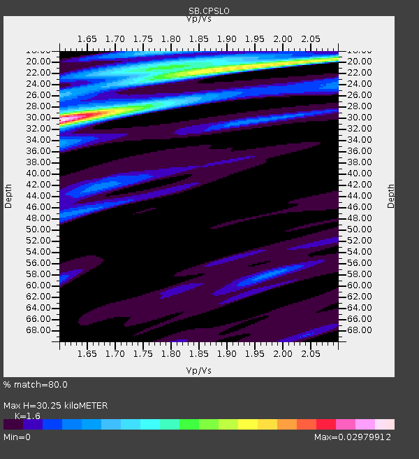
| Crust2 Type: | S1,continental slope, margin, transition 1 km seds. |
| Thickness Estimate: | 30 km |
| Thickness StdDev: | 3.2 km |
| Vp/Vs Estimate: | 1.60 |
| Vp/Vs StdDev: | 0.12 |
| Vs Estimate: | 3.864 km/s |
| Poisson's Ratio: | 0.18 |
| Peak Value: | 0.03 |
| Assumed Vp: | 6.183 km/s |
| Ps Weight: | 0.33333334 |
| PpPs Weight: | 0.33333334 |
| PsPs Weight: | 0.33333328 |
| Residual Complexity: | 0.718 |
| Nearby stations H: | +- |
| (2.0 deg) Vp/Vs: | +- |
4 with match > 90% ( 5.4054055 %) and 15 with match > 80% ( 20.27027 %) out of 74.
Download stack as xyz text file.
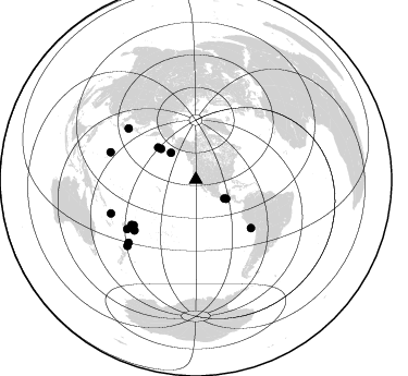
Azimuth Distribution of Events:
Prior Results for this Station
| Study | Thickness | Vp/Vs | Vp | Vs | Poissons Ratio | Extra |
| EARS | 30 km | 1.60 | 6.183 km/s | 3.864 km/s | 0.18 | |
| Crust2.0 | 23 km | 1.81 | 6.183 km/s | 3.422 km/s | 0.28 | S1,continental slope, margin, transition 1 km seds. |
| Global Maxima | 30 km | 1.60 | 6.183 km/s | 3.864 km/s | 0.18 | amp=0.029567052 |
| Local Maxima 1 | 20 km | 1.97 | 6.183 km/s | 3.146 km/s | 0.33 | amp=0.01736912 |
| Local Maxima 2 | 18 km | 1.77 | 6.183 km/s | 3.493 km/s | 0.27 | amp=0.008160033 |
| Local Maxima 3 | 21 km | 1.80 | 6.183 km/s | 3.44 km/s | 0.28 | amp=0.007858049 |
| Local Maxima 4 | 27 km | 1.75 | 6.183 km/s | 3.538 km/s | 0.26 | amp=0.0066392776 |
| Predicted Arrivals for vertical incidence (zero ray parameter) | |
| Ps | 2.91 SECOND |
| PpPs | 12.62 SECOND |
| PsPs/PpSs | 15.53 SECOND |
Events Processed for this Station
Download zip of receiver functions as SAC
Plot maxima for each earthquake.
Events Used in the Stack
(15 events)| Radial Match | Distance | Baz | FERegion | Time | Lat/Lon | Depth | Magnitude |
| 94.90189 | 77.8 deg | 307.284 deg | Near West Coast Of Honshu, Japan | 2024/01/01 07:10:10 UTC | (37.5, 137.2) | 0.0 km | 7.4 Mi |
| 93.45296 | 70.7 deg | 233.967 deg | Samoa Islands Region | 2022/12/04 19:24:15 UTC | (-15.4, -173.0) | 36 km | 6.7 Mww |
| 91.31899 | 87.2 deg | 226.109 deg | South Of Kermadec Islands | 2023/09/08 09:09:58 UTC | (-32.7, -179.3) | 90 km | 6.6 mww |
| 91.27065 | 67.1 deg | 131.02 deg | Near Coast Of Peru | 2024/06/28 05:36:37 UTC | (-15.8, -74.4) | 28 km | 7.2 mww |
| 89.89864 | 84.4 deg | 227.116 deg | Kermadec Islands, New Zealand | 2023/04/24 00:41:54 UTC | (-30.0, -177.9) | 34 km | 7.3 mww |
| 89.52254 | 33.7 deg | 317.312 deg | Alaska Peninsula | 2023/07/16 06:48:21 UTC | (54.5, -160.8) | 21 km | 7.3 Mi |
| 87.58588 | 77.6 deg | 234.404 deg | Fiji Islands Region | 2022/11/12 07:09:14 UTC | (-20.1, -178.4) | 587 km | 7.0 mww |
| 87.53654 | 71.9 deg | 235.027 deg | Tonga Islands | 2023/05/10 16:02:00 UTC | (-15.6, -174.6) | 210 km | 7.6 mww |
| 87.37361 | 31.4 deg | 123.235 deg | Near Coast Of Chiapas, Mexico | 2023/07/14 09:29:01 UTC | (15.0, -93.9) | 35 km | 6.3 mww |
| 87.295586 | 73.0 deg | 230.546 deg | Tonga Islands Region | 2022/11/11 10:48:45 UTC | (-19.3, -172.1) | 25 km | 7.3 Mww |
| 86.96586 | 42.8 deg | 311.557 deg | Andreanof Islands, Aleutian Is. | 2023/10/16 11:35:31 UTC | (52.4, -176.9) | 187 km | 6.4 Mww |
| 86.11512 | 32.8 deg | 122.074 deg | Near Coast Of Chiapas, Mexico | 2024/05/12 11:39:14 UTC | (14.5, -92.4) | 75 km | 6.4 mww |
| 85.41937 | 45.6 deg | 310.48 deg | Rat Islands, Aleutian Islands | 2022/12/14 18:40:26 UTC | (51.6, 178.6) | 73 km | 6.3 Mww |
| 84.403206 | 82.3 deg | 287.836 deg | Mariana Islands | 2024/04/05 11:03:16 UTC | (19.1, 145.4) | 222 km | 6.8 mww |
| 82.09787 | 83.9 deg | 248.401 deg | Vanuatu Islands | 2023/08/16 12:47:40 UTC | (-13.9, 167.2) | 193 km | 6.5 Mww |
Losers
(59 events)| Radial Match | Distance | Baz | FERegion | Time | Lat/Lon | Depth | Magnitude | Reason |
| 90.64858 | 95.9 deg | 267.474 deg | Eastern New Guinea Reg., P.N.G. | 2023/10/07 09:18:50 UTC | (-5.5, 146.0) | 69 km | 5.6 mb | |
| 90.33908 | 83.3 deg | 225.671 deg | Kermadec Islands Region | 2023/03/16 00:55:58 UTC | (-30.2, -175.9) | 10 km | 7.1 Mi | |
| 88.73405 | 73.6 deg | 233.435 deg | Tonga Islands | 2023/07/02 10:27:45 UTC | (-17.9, -174.7) | 247 km | 6.7 Mi | |
| 86.81161 | 57.5 deg | 314.731 deg | Near East Coast Of Kamchatka | 2023/04/03 03:06:55 UTC | (52.8, 158.6) | 100 km | 6.7 Mi | |
| 83.42289 | 64.6 deg | 309.423 deg | Kuril Islands | 2023/11/10 10:10:04 UTC | (45.9, 151.0) | 107 km | 5.8 mww | |
| 79.64017 | 75.9 deg | 232.9 deg | Tonga Islands | 2024/03/31 03:01:44 UTC | (-19.9, -176.0) | 10 km | 5.5 Mww | |
| 79.39435 | 88.2 deg | 225.617 deg | South Of Kermadec Islands | 2022/12/20 16:38:41 UTC | (-33.8, -179.7) | 39 km | 5.6 Mww | |
| 79.016884 | 30.8 deg | 121.259 deg | Chiapas, Mexico | 2023/08/09 09:33:26 UTC | (16.2, -93.6) | 111 km | 5.8 mww | |
| 78.92589 | 55.3 deg | 94.195 deg | Leeward Islands | 2023/01/20 11:23:40 UTC | (16.2, -62.0) | 165 km | 5.8 Mi | |
| 76.7141 | 84.5 deg | 228.058 deg | Kermadec Islands, New Zealand | 2023/03/04 06:41:22 UTC | (-29.5, -178.8) | 206 km | 6.9 mww | |
| 75.59098 | 34.3 deg | 120.277 deg | Guatemala | 2024/01/27 05:52:49 UTC | (14.1, -90.5) | 108 km | 6.1 Mww | |
| 74.52187 | 35.0 deg | 122.426 deg | Off Coast Of Central America | 2023/07/30 01:10:29 UTC | (12.7, -90.9) | 10 km | 5.7 Mww | |
| 73.38927 | 77.9 deg | 230.144 deg | Tonga Islands Region | 2023/01/11 11:30:27 UTC | (-23.2, -175.3) | 10 km | 5.6 Mww | |
| 73.115776 | 74.7 deg | 233.021 deg | Tonga Islands | 2024/01/18 22:12:20 UTC | (-18.9, -175.1) | 218 km | 6.4 Mww | |
| 72.83181 | 83.2 deg | 232.919 deg | South Of Fiji Islands | 2023/04/28 03:51:06 UTC | (-25.1, 178.5) | 572 km | 5.5 mb | |
| 71.359024 | 76.5 deg | 304.07 deg | Near East Coast Of Honshu, Japan | 2023/05/26 10:03:24 UTC | (35.6, 140.7) | 44 km | 6.2 mww | |
| 69.41828 | 89.4 deg | 264.055 deg | New Ireland Region, P.N.G. | 2023/09/29 01:19:37 UTC | (-4.6, 153.2) | 57 km | 5.5 Mww | |
| 69.27587 | 74.6 deg | 230.697 deg | Tonga Islands | 2023/12/23 23:44:46 UTC | (-20.4, -173.4) | 10 km | 5.6 mww | |
| 68.37307 | 86.7 deg | 142.612 deg | Southern Argentina | 2023/07/17 03:05:10 UTC | (-38.2, -70.4) | 171 km | 6.6 mww | |
| 68.02124 | 78.5 deg | 230.311 deg | Tonga Islands Region | 2023/06/16 20:30:44 UTC | (-23.5, -175.9) | 14 km | 5.5 Mww | |
| 67.85971 | 34.4 deg | 251.565 deg | Hawaii | 2023/12/05 03:53:46 UTC | (19.3, -155.2) | 2.1 km | 5.1 Ml | |
| 67.0462 | 72.0 deg | 309.564 deg | Hokkaido, Japan Region | 2023/06/11 09:54:45 UTC | (42.5, 141.9) | 125 km | 6.2 mww | |
| 66.808716 | 86.3 deg | 239.993 deg | Southeast Of Loyalty Islands | 2024/04/19 09:18:01 UTC | (-21.9, 170.8) | 96 km | 5.7 mww | |
| 66.788795 | 83.9 deg | 247.255 deg | Vanuatu Islands | 2023/07/26 12:44:35 UTC | (-14.8, 167.9) | 13 km | 6.4 mww | |
| 66.70662 | 34.8 deg | 251.471 deg | Hawaii | 2024/02/09 20:06:30 UTC | (19.0, -155.5) | 10 km | 6.3 Mi | |
| 66.41277 | 77.7 deg | 307.268 deg | Near West Coast Of Honshu, Japan | 2023/05/05 05:42:04 UTC | (37.5, 137.3) | 8.7 km | 6.2 mww | |
| 65.66916 | 86.6 deg | 241.912 deg | Vanuatu Islands | 2023/12/07 12:56:30 UTC | (-20.7, 169.2) | 48 km | 7.1 Mww | |
| 65.19523 | 81.7 deg | 298.107 deg | Bonin Islands, Japan Region | 2024/04/27 08:35:34 UTC | (27.8, 139.6) | 503 km | 6.5 mww | |
| 64.8836 | 72.1 deg | 307.93 deg | Hokkaido, Japan Region | 2023/08/11 00:14:32 UTC | (41.1, 142.8) | 30 km | 5.9 mww | |
| 64.847374 | 76.3 deg | 236.722 deg | Fiji Islands Region | 2023/10/31 11:10:56 UTC | (-17.5, -179.0) | 548 km | 6.4 mww | |
| 64.03331 | 62.8 deg | 122.424 deg | Western Brazil | 2024/01/20 21:31:07 UTC | (-7.3, -71.5) | 629 km | 6.5 Mww | |
| 63.824562 | 87.2 deg | 239.397 deg | Southeast Of Loyalty Islands | 2023/05/20 02:09:54 UTC | (-23.0, 170.5) | 10 km | 6.5 mww | |
| 63.5936 | 85.1 deg | 305.487 deg | Kyushu, Japan | 2024/04/08 01:25:29 UTC | (31.7, 131.4) | 54 km | 5.1 Mww | |
| 62.70187 | 90.8 deg | 88.274 deg | Central Mid-Atlantic Ridge | 2023/11/21 05:10:26 UTC | (1.0, -29.0) | 10 km | 5.5 Mww | |
| 62.42068 | 86.2 deg | 243.13 deg | Vanuatu Islands | 2023/10/29 04:32:08 UTC | (-19.4, 168.8) | 80 km | 6.0 mww | |
| 61.253956 | 87.0 deg | 239.98 deg | Southeast Of Loyalty Islands | 2023/06/08 09:19:28 UTC | (-22.4, 170.3) | 18 km | 5.7 mww | |
| 60.70246 | 82.7 deg | 291.672 deg | Volcano Islands, Japan Region | 2024/02/12 11:19:36 UTC | (22.0, 142.7) | 250 km | 6.1 mww | |
| 60.474953 | 80.1 deg | 234.372 deg | South Of Fiji Islands | 2023/01/12 16:28:51 UTC | (-21.9, 179.8) | 596 km | 5.5 Mww | |
| 60.00696 | 85.5 deg | 247.685 deg | Vanuatu Islands | 2023/03/02 18:04:29 UTC | (-15.4, 166.4) | 10 km | 6.5 Mww | |
| 59.94496 | 95.1 deg | 267.021 deg | Eastern New Guinea Reg., P.N.G. | 2023/03/14 00:49:08 UTC | (-5.4, 146.9) | 213 km | 6.3 mww | |
| 59.266586 | 72.1 deg | 233.784 deg | Tonga Islands | 2024/06/18 06:40:36 UTC | (-16.5, -173.8) | 35 km | 5.9 mww | |
| 58.421917 | 82.3 deg | 130.33 deg | Santiago Del Estero Prov., Arg. | 2023/01/20 22:09:39 UTC | (-26.7, -63.0) | 611 km | 6.8 mww | |
| 58.137005 | 59.9 deg | 42.966 deg | Reykjanes Ridge | 2022/11/29 23:50:37 UTC | (53.9, -35.1) | 10 km | 5.5 Mww | |
| 56.38884 | 72.6 deg | 306.355 deg | Off East Coast Of Honshu, Japan | 2023/08/24 22:48:26 UTC | (39.6, 143.3) | 35 km | 5.8 Mww | |
| 54.71916 | 92.3 deg | 267.285 deg | Bismarck Sea | 2023/04/10 01:05:49 UTC | (-3.6, 149.0) | 10 km | 5.9 mww | |
| 54.038242 | 86.0 deg | 227.731 deg | Kermadec Islands Region | 2023/11/13 14:40:55 UTC | (-30.7, -179.7) | 435 km | 5.7 Mww | |
| 51.710953 | 77.8 deg | 130.397 deg | Jujuy Province, Argentina | 2023/03/22 16:00:31 UTC | (-23.5, -66.5) | 210 km | 6.5 mww | |
| 51.645214 | 84.4 deg | 235.62 deg | South Of Fiji Islands | 2023/09/05 00:55:24 UTC | (-23.9, 175.5) | 12 km | 5.7 Mww | |
| 51.245064 | 70.6 deg | 233.447 deg | Samoa Islands Region | 2023/05/02 14:24:59 UTC | (-15.7, -172.5) | 35 km | 5.5 mww | |
| 49.99648 | 85.1 deg | 247.841 deg | Vanuatu Islands | 2023/03/02 18:05:31 UTC | (-15.0, 166.6) | 10 km | 5.7 mb | |
| 47.39238 | 72.5 deg | 308.639 deg | Hokkaido, Japan Region | 2023/05/05 17:47:15 UTC | (41.5, 142.0) | 53 km | 5.9 Mww | |
| 47.21186 | 84.0 deg | 247.046 deg | Vanuatu Islands | 2023/11/22 04:47:31 UTC | (-15.0, 168.0) | 13 km | 6.7 mww | |
| 47.068707 | 96.7 deg | 305.341 deg | Taiwan | 2024/04/22 18:32:48 UTC | (23.9, 121.6) | 10 km | 6.1 Mww | |
| 46.686337 | 77.7 deg | 307.234 deg | Near West Coast Of Honshu, Japan | 2023/05/05 12:58:04 UTC | (37.5, 137.3) | 14 km | 5.8 mb | |
| 45.136208 | 74.4 deg | 161.227 deg | Southeast Of Easter Island | 2023/09/14 22:51:26 UTC | (-36.5, -98.0) | 10 km | 5.6 mww | |
| 41.826706 | 87.6 deg | 225.598 deg | South Of Kermadec Islands | 2024/06/27 16:37:51 UTC | (-33.4, -179.2) | 32 km | 5.9 Mww | |
| 41.036602 | 77.8 deg | 136.123 deg | Near Coast Of Northern Chile | 2023/09/11 13:37:08 UTC | (-27.2, -71.2) | 21 km | 5.5 Mww | |
| 40.94156 | 83.3 deg | 131.467 deg | Santiago Del Estero Prov., Arg. | 2023/08/05 07:20:07 UTC | (-28.2, -63.2) | 598 km | 6.2 Mww | |
| 38.910088 | 78.9 deg | 137.493 deg | Near Coast Of Central Chile | 2024/02/14 01:31:41 UTC | (-28.9, -71.5) | 22 km | 6.0 mww |

