
Station SP JAMES - James Island High School, Charleston County, SC USA
Network: SP - South Carolina Earth Physics Project
Nearby stations (2 deg radius)
| Station | Name | (Lat, Lon) | Start / End | Elevation |
| JAMES | James Island High School, Charleston County, SC USA | (32.73, -79.93) | 2001-09-11 / 2499-01-01 | 7.0 m |
| Crust2 Type: | C2,continental shelf, 1 km seds. |
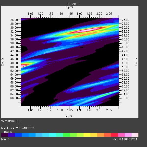
| Thickness Estimate: | 50 km |
| Thickness StdDev: | 9.4 km |
| Vp/Vs Estimate: | 1.60 |
| Vp/Vs StdDev: | 0.18 |
| Vs Estimate: | 3.9 km/s |
| Poisson's Ratio: | 0.18 |
| Peak Value: | 0.12 |
| Assumed Vp: | 6.24 km/s |
| Ps Weight: | 0.33333334 |
| PpPs Weight: | 0.33333334 |
| PsPs Weight: | 0.33333328 |
| Residual Complexity: | 0.872 |
| Nearby stations H: | +- |
| (2.0 deg) Vp/Vs: | +- |
3 with match > 90% ( 60.0 %) and 5 with match > 80% ( 100.0 %) out of 5.
Download stack as xyz text file.
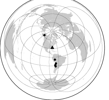
Azimuth Distribution of Events:
Prior Results for this Station
| Study | Thickness | Vp/Vs | Vp | Vs | Poissons Ratio | Extra |
| EARS | 50 km | 1.60 | 6.24 km/s | 3.9 km/s | 0.18 | |
| Crust2.0 | 30 km | 1.80 | 6.24 km/s | 3.467 km/s | 0.28 | C2,continental shelf, 1 km seds. |
| Global Maxima | 50 km | 1.60 | 6.24 km/s | 3.9 km/s | 0.18 | amp=0.116803244 |
| Local Maxima 1 | 31 km | 1.92 | 6.24 km/s | 3.242 km/s | 0.32 | amp=0.10387521 |
| Local Maxima 2 | 33 km | 1.97 | 6.24 km/s | 3.172 km/s | 0.33 | amp=0.07498513 |
| Local Maxima 3 | 64 km | 2.03 | 6.24 km/s | 3.07 km/s | 0.34 | amp=0.056100458 |
| Local Maxima 4 | 48 km | 1.60 | 6.24 km/s | 3.894 km/s | 0.18 | amp=0.04395067 |
| Predicted Arrivals for vertical incidence (zero ray parameter) | |
| Ps | 4.78 SECOND |
| PpPs | 20.73 SECOND |
| PsPs/PpSs | 25.51 SECOND |
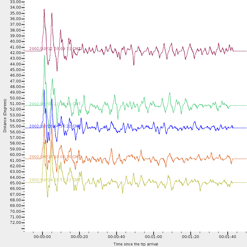
Events Processed for this Station
Download zip of receiver functions as SAC
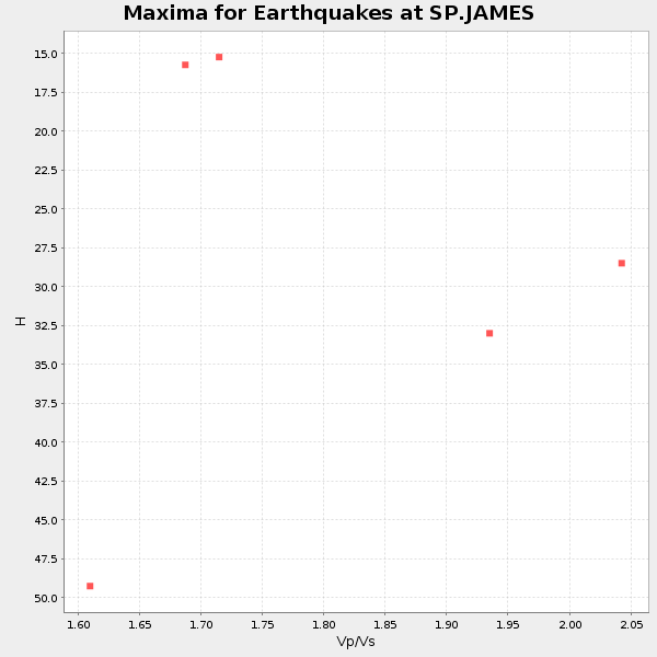
Plot maxima for each earthquake.
Events Used in the Stack
(5 events)| Radial Match | Distance | Baz | FERegion | Time | Lat/Lon | Depth | Magnitude |
| 94.865585 | 51.3 deg | 327.93 deg | Central Alaska | 2002/11/03 22:12:41 GMT | (63.5, -147.4) | 4.9 km | 7.0 MB, 8.5 MS, 7.9 MW |
| 90.59144 | 41.5 deg | 167.717 deg | Western Brazil | 2002/10/12 20:09:11 GMT | (-8.3, -71.7) | 534 km | 6.5 MB, 6.9 MW, 6.9 MW |
| 90.10571 | 60.6 deg | 170.47 deg | Near Coast Of Northern Chile | 2002/04/18 16:08:36 GMT | (-27.5, -70.6) | 62 km | 6.2 MB, 6.7 MW, 6.6 MW |
| 89.79216 | 64.7 deg | 169.868 deg | San Juan Province, Argentina | 2002/09/24 03:57:22 GMT | (-31.5, -69.2) | 120 km | 6.2 MB, 6.4 MW, 6.3 MW |
| 89.18771 | 55.2 deg | 166.831 deg | Chile-Bolivia Border Region | 2002/03/28 04:56:22 GMT | (-21.7, -68.3) | 125 km | 6.1 MB, 6.5 MW, 6.5 MW |
Losers
(0 events)| Radial Match | Distance | Baz | FERegion | Time | Lat/Lon | Depth | Magnitude | Reason |
