
Station SP OLAR - Denmark-Olar High School, Bamberg County, SC USA
Network: SP - South Carolina Earth Physics Project
Nearby stations (2 deg radius)
| Station | Name | (Lat, Lon) | Start / End | Elevation |
| OLAR | Denmark-Olar High School, Bamberg County, SC USA | (33.33, -81.13) | 2002-07-26 / 2499-01-01 | 61 m |
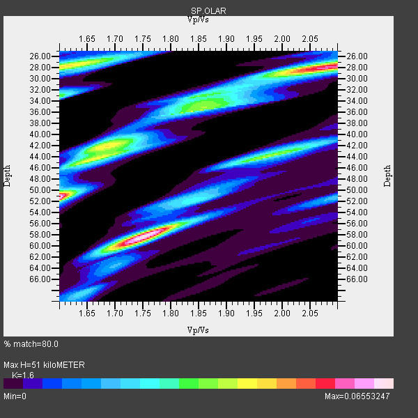
| Crust2 Type: | DG,thin Platform 1 km seds. |
| Thickness Estimate: | 51 km |
| Thickness StdDev: | 12 km |
| Vp/Vs Estimate: | 1.60 |
| Vp/Vs StdDev: | 0.18 |
| Vs Estimate: | 4.103 km/s |
| Poisson's Ratio: | 0.18 |
| Peak Value: | 0.07 |
| Assumed Vp: | 6.565 km/s |
| Ps Weight: | 0.33333334 |
| PpPs Weight: | 0.33333334 |
| PsPs Weight: | 0.33333328 |
| Residual Complexity: | 0.916 |
| Nearby stations H: | +- |
| (2.0 deg) Vp/Vs: | +- |
2 with match > 90% ( 40.0 %) and 5 with match > 80% ( 100.0 %) out of 5.
Download stack as xyz text file.
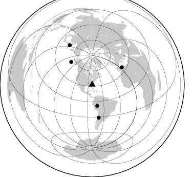
Azimuth Distribution of Events:
Prior Results for this Station
| Study | Thickness | Vp/Vs | Vp | Vs | Poissons Ratio | Extra |
| EARS | 51 km | 1.60 | 6.565 km/s | 4.103 km/s | 0.18 | |
| Crust2.0 | 31 km | 1.78 | 6.565 km/s | 3.684 km/s | 0.27 | DG,thin Platform 1 km seds. |
| Global Maxima | 51 km | 1.60 | 6.565 km/s | 4.103 km/s | 0.18 | amp=0.06553247 |
| Local Maxima 1 | 58 km | 1.75 | 6.565 km/s | 3.751 km/s | 0.26 | amp=0.06536046 |
| Local Maxima 2 | 28 km | 2.08 | 6.565 km/s | 3.156 km/s | 0.35 | amp=0.055265244 |
| Local Maxima 3 | 28 km | 1.62 | 6.565 km/s | 4.058 km/s | 0.19 | amp=0.04300658 |
| Local Maxima 4 | 42 km | 1.68 | 6.565 km/s | 3.902 km/s | 0.23 | amp=0.040346906 |
| Predicted Arrivals for vertical incidence (zero ray parameter) | |
| Ps | 4.66 SECOND |
| PpPs | 20.20 SECOND |
| PsPs/PpSs | 24.86 SECOND |
Events Processed for this Station
Download zip of receiver functions as SAC
Plot maxima for each earthquake.
Events Used in the Stack
(5 events)| Radial Match | Distance | Baz | FERegion | Time | Lat/Lon | Depth | Magnitude |
| 92.81338 | 42.3 deg | 166.125 deg | Western Brazil | 2002/10/12 20:09:11 GMT | (-8.3, -71.7) | 534 km | 6.5 MB, 6.9 MW, 6.9 MW |
| 90.49983 | 67.1 deg | 59.956 deg | Northern Algeria | 2003/05/21 18:44:20 GMT | (37.0, 3.6) | 12 km | 6.5 MB, 6.9 MS, 6.8 MW, 6.7 MW |
| 87.28215 | 65.5 deg | 168.81 deg | San Juan Province, Argentina | 2002/09/24 03:57:22 GMT | (-31.5, -69.2) | 120 km | 6.2 MB, 6.4 MW, 6.3 MW |
| 84.80899 | 60.3 deg | 317.069 deg | Unimak Island Region, Alaska | 2003/02/19 03:32:36 GMT | (53.6, -164.6) | 19 km | 5.8 MB, 6.6 MS, 6.6 MW, 6.6 MW |
| 81.14658 | 88.8 deg | 330.285 deg | Northwest Of Kuril Islands | 2002/11/17 04:53:53 GMT | (47.8, 146.2) | 459 km | 7.3 MW, 7.3 MW |
Losers
(0 events)| Radial Match | Distance | Baz | FERegion | Time | Lat/Lon | Depth | Magnitude | Reason |
