
Station SP TIMBR - Timberland High School, Berkeley County, SC USA
Network: SP - South Carolina Earth Physics Project
Nearby stations (2 deg radius)

| Station | Name | (Lat, Lon) | Start / End | Elevation |
| TIMBR | Timberland High School, Berkeley County, SC USA | (33.34, -79.89) | 2001-09-11 / 2499-01-01 | 12 m |
| Crust2 Type: | C2,continental shelf, 1 km seds. |
| Thickness Estimate: | 32 km |
| Thickness StdDev: | 2.8 km |
| Vp/Vs Estimate: | 1.82 |
| Vp/Vs StdDev: | 0.07 |
| Vs Estimate: | 3.429 km/s |
| Poisson's Ratio: | 0.28 |
| Peak Value: | 0.12 |
| Assumed Vp: | 6.24 km/s |
| Ps Weight: | 0.33333334 |
| PpPs Weight: | 0.33333334 |
| PsPs Weight: | 0.33333328 |
| Residual Complexity: | 0.591 |
| Nearby stations H: | +- |
| (2.0 deg) Vp/Vs: | +- |
7 with match > 90% ( 58.333332 %) and 11 with match > 80% ( 91.666664 %) out of 12.
Download stack as xyz text file.
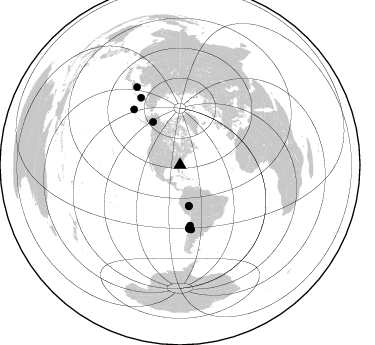
Azimuth Distribution of Events:
Prior Results for this Station
| Study | Thickness | Vp/Vs | Vp | Vs | Poissons Ratio | Extra |
| EARS | 32 km | 1.82 | 6.24 km/s | 3.429 km/s | 0.28 | |
| Crust2.0 | 30 km | 1.80 | 6.24 km/s | 3.467 km/s | 0.28 | C2,continental shelf, 1 km seds. |
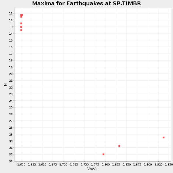
| Global Maxima | 32 km | 1.82 | 6.24 km/s | 3.429 km/s | 0.28 | amp=0.119090475 |
| Local Maxima 1 | 41 km | 1.69 | 6.24 km/s | 3.687 km/s | 0.23 | amp=0.073639855 |
| Local Maxima 2 | 34 km | 1.63 | 6.24 km/s | 3.828 km/s | 0.20 | amp=0.05194906 |
| Local Maxima 3 | 25 km | 1.95 | 6.24 km/s | 3.196 km/s | 0.32 | amp=0.048924875 |
| Local Maxima 4 | 40 km | 1.65 | 6.24 km/s | 3.788 km/s | 0.21 | amp=0.034874436 |
| Predicted Arrivals for vertical incidence (zero ray parameter) | |
| Ps | 4.14 SECOND |
| PpPs | 14.24 SECOND |
| PsPs/PpSs | 18.38 SECOND |
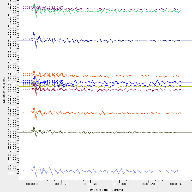
Events Processed for this Station
Download zip of receiver functions as SAC
Plot maxima for each earthquake.
Events Used in the Stack
(11 events)| Radial Match | Distance | Baz | FERegion | Time | Lat/Lon | Depth | Magnitude |
| 96.86387 | 50.8 deg | 327.669 deg | Central Alaska | 2002/11/03 22:12:41 GMT | (63.5, -147.4) | 4.9 km | 7.0 MB, 8.5 MS, 7.9 MW |
| 95.85265 | 72.2 deg | 320.231 deg | Rat Islands, Aleutian Islands | 2003/06/23 12:12:34 GMT | (51.4, 176.8) | 20 km | 6.3 MB, 7.0 MS, 6.9 MW, 6.8 MW |
| 94.51883 | 64.1 deg | 172.09 deg | Near Coast Of Central Chile | 2003/06/20 13:30:41 GMT | (-30.6, -71.6) | 33 km | 6.4 MB, 6.8 MS, 6.8 MW, 6.7 MW |
| 94.37827 | 64.3 deg | 171.634 deg | Near Coast Of Central Chile | 2002/06/18 13:56:22 GMT | (-30.8, -71.1) | 54 km | 6.0 MB, 6.6 MW, 6.4 MW |
| 93.581154 | 77.8 deg | 329.76 deg | Kamchatka Peninsula, Russia | 2003/06/16 22:08:02 GMT | (55.5, 160.0) | 175 km | 6.3 MB, 6.9 MW, 6.9 MW |
| 91.185555 | 42.1 deg | 167.921 deg | Western Brazil | 2002/10/12 20:09:11 GMT | (-8.3, -71.7) | 534 km | 6.5 MB, 6.9 MW, 6.9 MW |
| 90.419876 | 41.4 deg | 167.714 deg | Western Brazil | 2003/06/20 06:19:38 GMT | (-7.6, -71.7) | 558 km | 6.4 MB, 7.1 MW, 7.0 MW |
| 89.55998 | 65.3 deg | 169.957 deg | San Juan Province, Argentina | 2002/09/24 03:57:22 GMT | (-31.5, -69.2) | 120 km | 6.2 MB, 6.4 MW, 6.3 MW |
| 84.223885 | 61.2 deg | 170.568 deg | Near Coast Of Northern Chile | 2002/04/18 16:08:36 GMT | (-27.5, -70.6) | 62 km | 6.2 MB, 6.7 MW, 6.6 MW |
| 81.70465 | 89.3 deg | 330.948 deg | Northwest Of Kuril Islands | 2002/11/17 04:53:53 GMT | (47.8, 146.2) | 459 km | 7.3 MW, 7.3 MW |
| 80.472786 | 63.2 deg | 171.706 deg | Near Coast Of Central Chile | 2002/04/01 19:59:32 GMT | (-29.7, -71.4) | 71 km | 6.1 MB, 6.4 MW, 6.4 MW |
Losers
(1 events)| Radial Match | Distance | Baz | FERegion | Time | Lat/Lon | Depth | Magnitude | Reason |
| 90.35417 | 66.2 deg | 60.415 deg | Northern Algeria | 2003/05/21 18:44:20 GMT | (37.0, 3.6) | 12 km | 6.5 MB, 6.9 MS, 6.8 MW, 6.7 MW |
