
Station SP WOAK - West-Oak High School, Oconee County, SC USA
Network: SP - South Carolina Earth Physics Project
Nearby stations (2 deg radius)
| Station | Name | (Lat, Lon) | Start / End | Elevation |
| WOAK | West-Oak High School, Oconee County, SC USA | (34.62, -83.05) | 2001-09-17 / 2499-01-01 | 268 m |
| Crust2 Type: | P6,orogen/43km, Orogen, 0.5 km seds. |
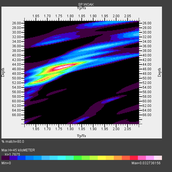
| Thickness Estimate: | 45 km |
| Thickness StdDev: | 7.9 km |
| Vp/Vs Estimate: | 1.77 |
| Vp/Vs StdDev: | 0.10 |
| Vs Estimate: | 3.593 km/s |
| Poisson's Ratio: | 0.26 |
| Peak Value: | 0.03 |
| Assumed Vp: | 6.35 km/s |
| Ps Weight: | 0.33333334 |
| PpPs Weight: | 0.33333334 |
| PsPs Weight: | 0.33333328 |
| Residual Complexity: | 0.532 |
| Nearby stations H: | +- |
| (2.0 deg) Vp/Vs: | +- |
6 with match > 90% ( 54.545456 %) and 11 with match > 80% ( 100.0 %) out of 11.
Download stack as xyz text file.
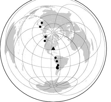
Azimuth Distribution of Events:
Prior Results for this Station
| Study | Thickness | Vp/Vs | Vp | Vs | Poissons Ratio | Extra |
| EARS | 45 km | 1.77 | 6.35 km/s | 3.593 km/s | 0.26 | |
| Crust2.0 | 43 km | 1.76 | 6.35 km/s | 3.609 km/s | 0.26 | P6,orogen/43km, Orogen, 0.5 km seds. |
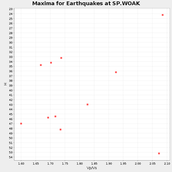
| Global Maxima | 45 km | 1.77 | 6.35 km/s | 3.593 km/s | 0.26 | amp=0.032736156 |
| Local Maxima 1 | 51 km | 1.66 | 6.35 km/s | 3.82 km/s | 0.22 | amp=0.021863064 |
| Local Maxima 2 | 48 km | 1.69 | 6.35 km/s | 3.769 km/s | 0.23 | amp=0.012104669 |
| Local Maxima 3 | 45 km | 1.70 | 6.35 km/s | 3.735 km/s | 0.24 | amp=0.009388547 |
| Local Maxima 4 | 35 km | 1.99 | 6.35 km/s | 3.199 km/s | 0.33 | amp=0.008629645 |
| Predicted Arrivals for vertical incidence (zero ray parameter) | |
| Ps | 5.44 SECOND |
| PpPs | 19.61 SECOND |
| PsPs/PpSs | 25.05 SECOND |
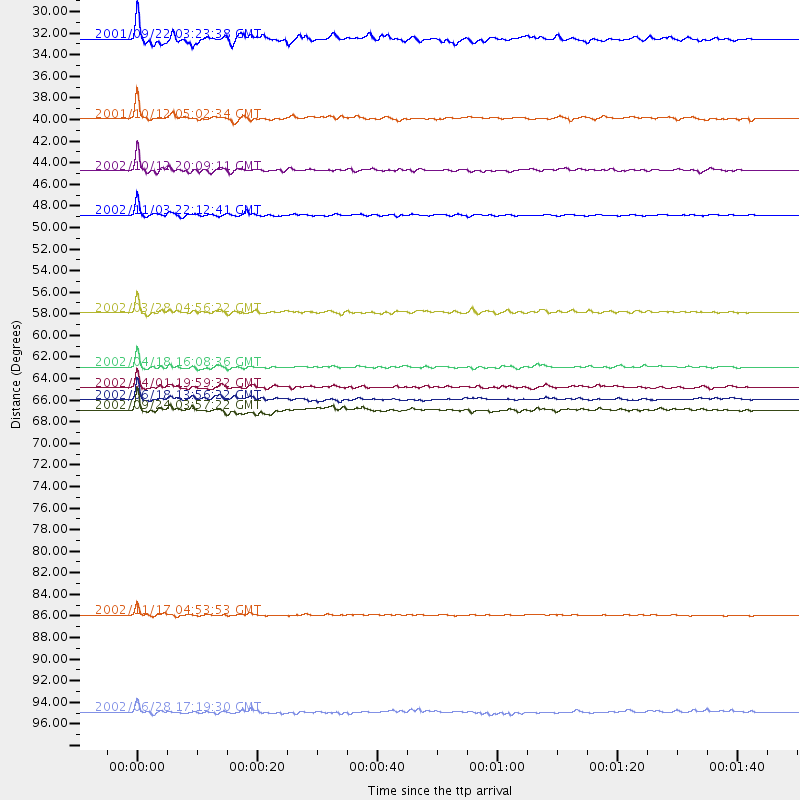
Events Processed for this Station
Download zip of receiver functions as SAC
Plot maxima for each earthquake.
Events Used in the Stack
(11 events)| Radial Match | Distance | Baz | FERegion | Time | Lat/Lon | Depth | Magnitude |
| 97.46756 | 48.3 deg | 327.21 deg | Central Alaska | 2002/11/03 22:12:41 GMT | (63.5, -147.4) | 4.9 km | 7.0 MB, 8.5 MS, 7.9 MW |
| 96.38538 | 44.0 deg | 163.771 deg | Western Brazil | 2002/10/12 20:09:11 GMT | (-8.3, -71.7) | 534 km | 6.5 MB, 6.9 MW, 6.9 MW |
| 93.2362 | 57.7 deg | 163.758 deg | Chile-Bolivia Border Region | 2002/03/28 04:56:22 GMT | (-21.7, -68.3) | 125 km | 6.1 MB, 6.5 MW, 6.5 MW |
| 92.865555 | 66.0 deg | 168.778 deg | Near Coast Of Central Chile | 2002/06/18 13:56:22 GMT | (-30.8, -71.1) | 54 km | 6.0 MB, 6.6 MW, 6.4 MW |
| 92.632324 | 86.8 deg | 329.244 deg | Northwest Of Kuril Islands | 2002/11/17 04:53:53 GMT | (47.8, 146.2) | 459 km | 7.3 MW, 7.3 MW |
| 92.57162 | 62.9 deg | 167.569 deg | Near Coast Of Northern Chile | 2002/04/18 16:08:36 GMT | (-27.5, -70.6) | 62 km | 6.2 MB, 6.7 MW, 6.6 MW |
| 89.238785 | 96.2 deg | 336.134 deg | E. Russia-N.E. China Border Reg. | 2002/06/28 17:19:30 GMT | (43.8, 130.7) | 566 km | 6.7 MB, 7.3 MW, 7.3 MW |
| 86.968124 | 67.1 deg | 167.173 deg | San Juan Province, Argentina | 2002/09/24 03:57:22 GMT | (-31.5, -69.2) | 120 km | 6.2 MB, 6.4 MW, 6.3 MW |
| 84.54836 | 39.0 deg | 312.891 deg | Queen Charlotte Islands Region | 2001/10/12 05:02:34 GMT | (52.6, -132.2) | 20 km | 5.6 MB, 5.8 MS, 6.2 MW, 6.1 MW |
| 83.38304 | 31.3 deg | 166.297 deg | Colombia | 2001/09/22 03:23:38 GMT | (3.9, -76.0) | 179 km | 6.0 MB, 6.0 MW, 6.0 MW |
| 82.29414 | 64.9 deg | 168.791 deg | Near Coast Of Central Chile | 2002/04/01 19:59:32 GMT | (-29.7, -71.4) | 71 km | 6.1 MB, 6.4 MW, 6.4 MW |
Losers
(0 events)| Radial Match | Distance | Baz | FERegion | Time | Lat/Lon | Depth | Magnitude | Reason |
