
Station SV TACO - TACACHICO
Network: SV - Servicio Nacional de Estudios Territoriales (SNET), El Salvador
Nearby stations (2 deg radius)
| Station | Name | (Lat, Lon) | Start / End | Elevation |
| TACO | TACACHICO | (13.97, -89.35) | 2014-05-26 / 2599-12-31 | 357 m |
| Crust2 Type: | S2,continental slope, margin, transition 2 km seds. |
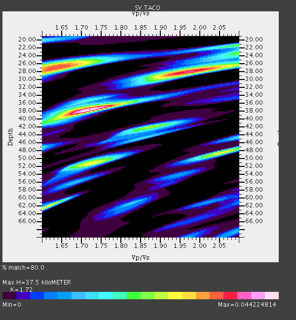
| Thickness Estimate: | 38 km |
| Thickness StdDev: | 9.4 km |
| Vp/Vs Estimate: | 1.72 |
| Vp/Vs StdDev: | 0.18 |
| Vs Estimate: | 3.516 km/s |
| Poisson's Ratio: | 0.24 |
| Peak Value: | 0.04 |
| Assumed Vp: | 6.048 km/s |
| Ps Weight: | 0.33333334 |
| PpPs Weight: | 0.33333334 |
| PsPs Weight: | 0.33333328 |
| Residual Complexity: | 0.842 |
| Nearby stations H: | +- |
| (2.0 deg) Vp/Vs: | +- |
0 with match > 90% ( 0.0 %) and 2 with match > 80% ( 12.5 %) out of 16.
Download stack as xyz text file.
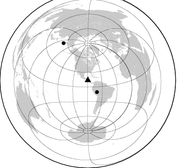
Azimuth Distribution of Events:
Prior Results for this Station
| Study | Thickness | Vp/Vs | Vp | Vs | Poissons Ratio | Extra |
| EARS | 38 km | 1.72 | 6.048 km/s | 3.516 km/s | 0.24 | |
| Crust2.0 | 24 km | 1.81 | 6.048 km/s | 3.34 km/s | 0.28 | S2,continental slope, margin, transition 2 km seds. |
| Global Maxima | 38 km | 1.72 | 6.048 km/s | 3.516 km/s | 0.24 | amp=0.044224814 |
| Local Maxima 1 | 28 km | 1.96 | 6.048 km/s | 3.082 km/s | 0.32 | amp=0.036446396 |
| Local Maxima 2 | 27 km | 1.63 | 6.048 km/s | 3.699 km/s | 0.20 | amp=0.034857456 |
| Local Maxima 3 | 62 km | 1.61 | 6.048 km/s | 3.756 km/s | 0.19 | amp=0.029617429 |
| Local Maxima 4 | 51 km | 1.72 | 6.048 km/s | 3.511 km/s | 0.25 | amp=0.027760722 |
| Predicted Arrivals for vertical incidence (zero ray parameter) | |
| Ps | 4.46 SECOND |
| PpPs | 16.87 SECOND |
| PsPs/PpSs | 21.33 SECOND |
Events Processed for this Station
Download zip of receiver functions as SAC
Plot maxima for each earthquake.
Events Used in the Stack
(2 events)| Radial Match | Distance | Baz | FERegion | Time | Lat/Lon | Depth | Magnitude |
| 82.254105 | 91.3 deg | 326.846 deg | Kamchatka Peninsula, Russia | 2016/01/30 03:25:10 GMT | (54.0, 158.5) | 161 km | 7.2 MWW, 7.0 MI, 7.2 MWB |
| 81.76425 | 30.5 deg | 142.279 deg | Peru-Brazil Border Region | 2015/11/24 22:45:38 GMT | (-10.6, -71.0) | 602 km | 7.5 MWW, 6.9 MI |
Losers
(14 events)| Radial Match | Distance | Baz | FERegion | Time | Lat/Lon | Depth | Magnitude | Reason |
| 73.66123 | 47.5 deg | 159.145 deg | Near Coast Of Central Chile | 2016/02/10 00:33:05 GMT | (-30.6, -71.6) | 32 km | 6.3 MWB | |
| 59.640217 | 47.5 deg | 159.22 deg | Near Coast Of Central Chile | 2016/01/08 01:12:00 GMT | (-30.7, -71.7) | 31 km | 5.6 MWR | |
| 56.534576 | 87.0 deg | 150.514 deg | South Sandwich Islands Region | 2016/03/14 07:26:43 GMT | (-56.4, -27.1) | 104 km | 5.7 MB | |
| 55.70999 | 42.7 deg | 154.507 deg | Near Coast Of Northern Chile | 2015/11/27 21:00:22 GMT | (-24.8, -70.6) | 35 km | 6.2 MWW, 6.2 MWB | |
| 50.236107 | 78.6 deg | 55.86 deg | Strait Of Gibraltar | 2016/01/25 04:22:02 GMT | (35.7, -3.6) | 10 km | 6.1 MWP | |
| 41.216183 | 61.9 deg | 96.391 deg | Central Mid-Atlantic Ridge | 2016/01/27 15:11:17 GMT | (1.0, -28.1) | 10 km | 5.7 mwc | |
| 40.882698 | 75.9 deg | 320.144 deg | Andreanof Islands, Aleutian Is. | 2016/03/12 18:06:45 GMT | (51.6, -174.0) | 19 km | 6.3 MWW, 6.1 MB, 6.2 MWB, 6.3 MWC, 6.4 MWC, 6.4 MI | |
| 36.975883 | 86.7 deg | 150.469 deg | South Sandwich Islands Region | 2016/02/18 01:07:14 GMT | (-56.2, -27.6) | 119 km | 5.8 MB | |
| 34.35758 | 96.5 deg | 237.82 deg | South Of Kermadec Islands | 2016/03/05 18:45:30 GMT | (-32.9, -178.2) | 10 km | 5.5 MB | |
| 34.303146 | 44.5 deg | 146.727 deg | Jujuy Province, Argentina | 2015/11/29 18:52:49 GMT | (-23.5, -64.6) | 9.6 km | 5.9 MWP | |
| 32.96217 | 89.4 deg | 254.285 deg | Tonga Islands | 2016/01/13 05:55:59 GMT | (-15.2, -174.9) | 233 km | 5.8 MB | |
| 30.847227 | 56.6 deg | 93.558 deg | Central Mid-Atlantic Ridge | 2016/02/21 01:26:02 GMT | (4.7, -32.6) | 10 km | 5.3 mb | |
| 26.911991 | 47.6 deg | 158.882 deg | Near Coast Of Central Chile | 2015/12/19 19:25:04 GMT | (-30.6, -71.4) | 46 km | 5.8 MWR | |
| 24.19709 | 43.4 deg | 214.097 deg | Easter Island Region | 2016/01/23 10:08:01 GMT | (-22.4, -114.0) | 10 km | 5.5 MB |

