
Station TA 062Z - Marathon, FL, USA
Network: TA - USArray Transportable Network (new EarthScope stations)
Nearby stations (2 deg radius)
| Station | Name | (Lat, Lon) | Start / End | Elevation |
| 062Z | Marathon, FL, USA | (24.73, -81.05) | 2012-05-15 / 2599-12-31 | 5.0 m |
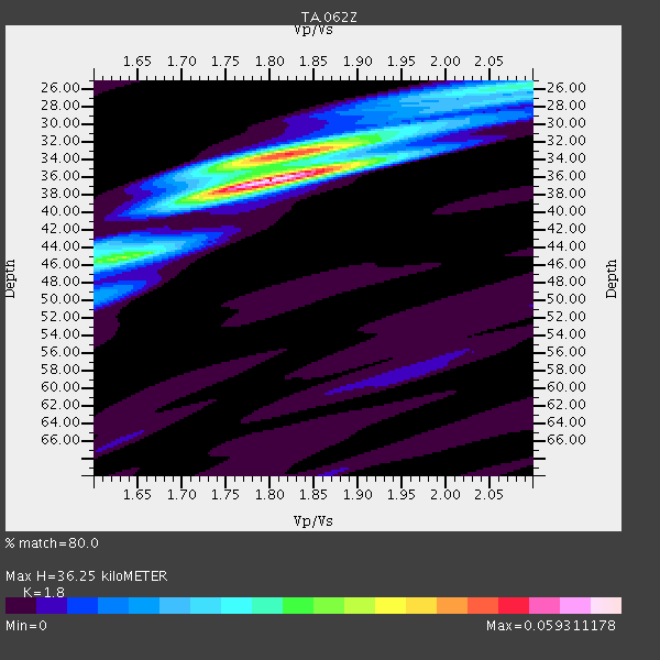
| Crust2 Type: | C6,continental shelf, 7.5 km seds. |
| Thickness Estimate: | 36 km |
| Thickness StdDev: | 3.8 km |
| Vp/Vs Estimate: | 1.80 |
| Vp/Vs StdDev: | 0.08 |
| Vs Estimate: | 3.211 km/s |
| Poisson's Ratio: | 0.28 |
| Peak Value: | 0.06 |
| Assumed Vp: | 5.78 km/s |
| Ps Weight: | 0.33333334 |
| PpPs Weight: | 0.33333334 |
| PsPs Weight: | 0.33333328 |
| Residual Complexity: | 0.569 |
| Nearby stations H: | +- |
| (2.0 deg) Vp/Vs: | +- |
3 with match > 90% ( 20.0 %) and 8 with match > 80% ( 53.333332 %) out of 15.
Download stack as xyz text file.
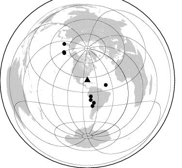
Azimuth Distribution of Events:
Prior Results for this Station
| Study | Thickness | Vp/Vs | Vp | Vs | Poissons Ratio | Extra |
| EARS | 36 km | 1.80 | 5.78 km/s | 3.211 km/s | 0.28 | |
| Crust2.0 | 32 km | 1.81 | 5.78 km/s | 3.191 km/s | 0.28 | C6,continental shelf, 7.5 km seds. |
| Global Maxima | 36 km | 1.80 | 5.78 km/s | 3.211 km/s | 0.28 | amp=0.059311178 |
| Local Maxima 1 | 34 km | 1.80 | 5.78 km/s | 3.206 km/s | 0.28 | amp=0.03961628 |
| Local Maxima 2 | 45 km | 1.62 | 5.78 km/s | 3.568 km/s | 0.19 | amp=0.026590178 |
| Local Maxima 3 | 26 km | 2.09 | 5.78 km/s | 2.769 km/s | 0.35 | amp=0.016049523 |
| Local Maxima 4 | 34 km | 1.92 | 5.78 km/s | 3.006 km/s | 0.31 | amp=0.012303642 |
| Predicted Arrivals for vertical incidence (zero ray parameter) | |
| Ps | 5.02 SECOND |
| PpPs | 17.56 SECOND |
| PsPs/PpSs | 22.58 SECOND |
Events Processed for this Station
Download zip of receiver functions as SAC
Plot maxima for each earthquake.
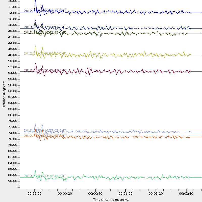
Events Used in the Stack
(8 events)| Radial Match | Distance | Baz | FERegion | Time | Lat/Lon | Depth | Magnitude |
| 95.59611 | 73.5 deg | 319.492 deg | Andreanof Islands, Aleutian Is. | 2013/08/30 16:25:02 GMT | (51.5, -175.2) | 29 km | 7.0 MWW, 6.5 ML, 6.8 MI, 6.9 MWC, 6.9 MWB, 7.0 MWW, 7.0 MI, 7.0 MWC |
| 92.654015 | 40.8 deg | 170.344 deg | Near Coast Of Peru | 2013/09/25 16:42:43 GMT | (-15.8, -74.5) | 40 km | 7.1 MWW, 6.8 MI, 7.0 MWB, 7.0 MWC, 7.1 MWW, 7.1 MWC |
| 92.247185 | 75.3 deg | 320.227 deg | Andreanof Islands, Aleutian Is. | 2012/09/26 23:39:55 GMT | (51.6, -178.3) | 16 km | 6.3 MB, 6.5 MS, 6.4 MW, 6.4 MW |
| 84.14826 | 33.6 deg | 167.791 deg | Peru-Brazil Border Region | 2012/08/02 09:38:30 GMT | (-8.4, -74.3) | 145 km | 5.9 MB, 6.1 MW, 6.1 MW |
| 80.49903 | 88.8 deg | 327.375 deg | Kuril Islands | 2013/03/01 13:20:49 GMT | (51.0, 157.4) | 29 km | 6.3 MB, 6.3 MS, 6.5 MW, 6.4 MW |
| 80.33114 | 47.8 deg | 163.754 deg | Chile-Bolivia Border Region | 2012/10/08 01:50:26 GMT | (-21.7, -68.2) | 122 km | 6.0 MB, 5.7 MW, 5.8 MW |
| 80.08806 | 53.5 deg | 168.552 deg | Central Chile | 2013/01/30 20:15:43 GMT | (-28.1, -70.7) | 45 km | 6.5 MB, 6.5 MS, 6.8 MW, 6.8 MW |
| 80.019714 | 39.0 deg | 103.997 deg | Northern Mid-Atlantic Ridge | 2013/06/24 22:04:13 GMT | (10.7, -42.6) | 10 km | 6.5 MW, 6.1 MB, 6.3 MS, 6.6 MW |
Losers
(7 events)| Radial Match | Distance | Baz | FERegion | Time | Lat/Lon | Depth | Magnitude | Reason |
| 97.34522 | 88.1 deg | 332.015 deg | Sea Of Okhotsk | 2013/05/24 05:44:48 GMT | (54.9, 153.2) | 598 km | 8.4 MW, 7.5 MB, 8.3 MW | |
| 79.206825 | 90.7 deg | 330.796 deg | Sea Of Okhotsk | 2013/05/24 14:56:31 GMT | (52.2, 151.4) | 624 km | 6.7 MW, 6.7 MB, 6.7 MW | |
| 72.79468 | 30.0 deg | 181.744 deg | Near Coast Of Northern Peru | 2013/08/12 09:49:32 GMT | (-5.4, -81.9) | 10 km | 6.2 MWW, 6.1 MWB, 6.2 MWW, 6.2 MWC, 6.3 MWC | |
| 70.54431 | 55.1 deg | 160.584 deg | Santiago Del Estero Prov., Arg. | 2013/02/22 12:01:58 GMT | (-27.9, -63.1) | 575 km | 5.8 MB, 6.1 MW, 6.2 MW | |
| 63.832462 | 82.4 deg | 344.568 deg | Eastern Siberia, Russia | 2013/02/14 13:13:53 GMT | (67.6, 142.5) | 11 km | 6.5 MB, 6.7 MS, 6.6 MW, 6.7 MW | |
| 62.29296 | 89.5 deg | 330.939 deg | Sea Of Okhotsk | 2013/10/01 03:38:21 GMT | (53.2, 152.8) | 573 km | 6.7 MWW, 6.7 MWC, 6.8 MWC, 6.8 MWB | |
| 60.993946 | 75.3 deg | 320.282 deg | Andreanof Islands, Aleutian Is. | 2013/04/21 13:48:29 GMT | (51.7, -178.2) | 44 km | 5.6 MW, 5.7 MW, 5.9 MB |
