
Station TA 552A - Lynn Haven, FL, USA
Network: TA - USArray Transportable Network (new EarthScope stations)
Nearby stations (2 deg radius)
| Station | Name | (Lat, Lon) | Start / End | Elevation |
| 552A | Lynn Haven, FL, USA | (30.13, -85.29) | 2012-02-06 / 2599-12-31 | 17 m |
| Crust2 Type: | DH,thin Platform 4 km seds. |
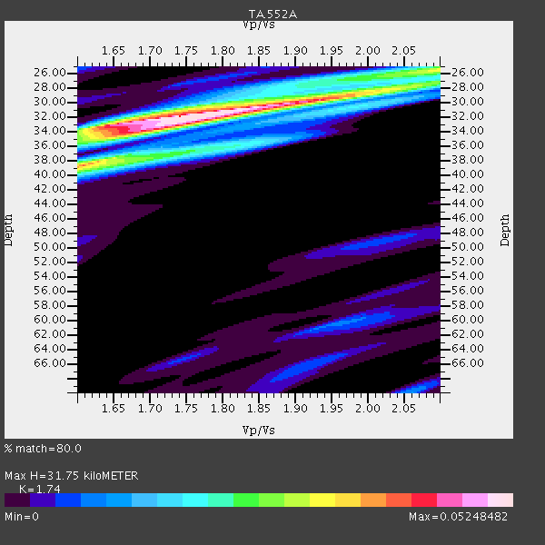
| Thickness Estimate: | 32 km |
| Thickness StdDev: | 2.3 km |
| Vp/Vs Estimate: | 1.74 |
| Vp/Vs StdDev: | 0.09 |
| Vs Estimate: | 3.648 km/s |
| Poisson's Ratio: | 0.25 |
| Peak Value: | 0.05 |
| Assumed Vp: | 6.347 km/s |
| Ps Weight: | 0.33333334 |
| PpPs Weight: | 0.33333334 |
| PsPs Weight: | 0.33333328 |
| Residual Complexity: | 0.611 |
| Nearby stations H: | +- |
| (2.0 deg) Vp/Vs: | +- |
1 with match > 90% ( 3.4482758 %) and 5 with match > 80% ( 17.241379 %) out of 29.
Download stack as xyz text file.
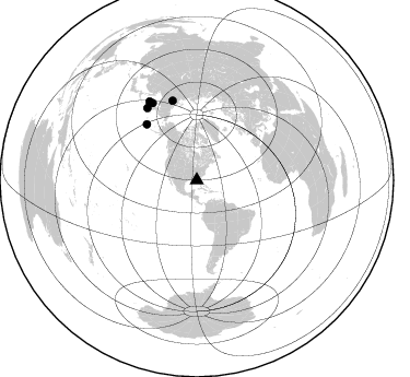
Azimuth Distribution of Events:
Prior Results for this Station
| Study | Thickness | Vp/Vs | Vp | Vs | Poissons Ratio | Extra |
| EARS | 32 km | 1.74 | 6.347 km/s | 3.648 km/s | 0.25 | |
| Crust2.0 | 34 km | 1.79 | 6.347 km/s | 3.553 km/s | 0.27 | DH,thin Platform 4 km seds. |
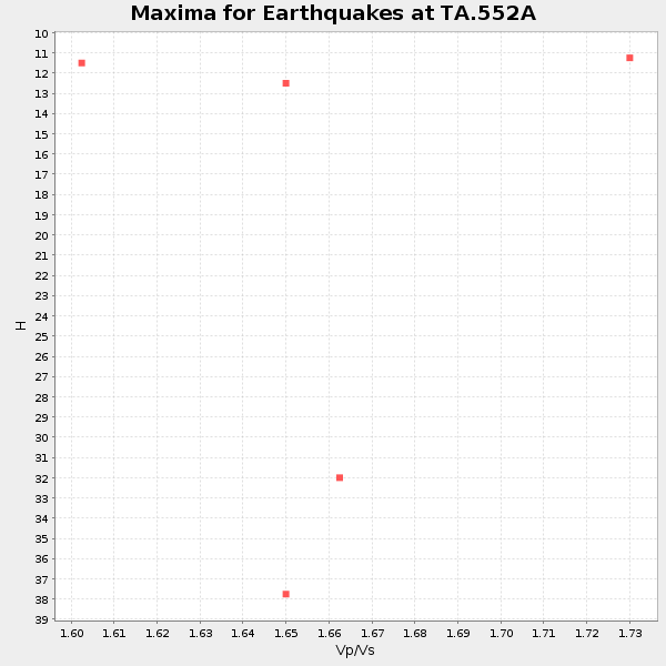
| Global Maxima | 32 km | 1.74 | 6.347 km/s | 3.648 km/s | 0.25 | amp=0.05248482 |
| Local Maxima 1 | 25 km | 2.10 | 6.347 km/s | 3.026 km/s | 0.35 | amp=0.031961363 |
| Local Maxima 2 | 38 km | 1.61 | 6.347 km/s | 3.948 km/s | 0.18 | amp=0.030304827 |
| Local Maxima 3 | 30 km | 1.91 | 6.347 km/s | 3.323 km/s | 0.31 | amp=0.024745978 |
| Local Maxima 4 | 34 km | 1.68 | 6.347 km/s | 3.789 km/s | 0.22 | amp=0.02115569 |
| Predicted Arrivals for vertical incidence (zero ray parameter) | |
| Ps | 3.70 SECOND |
| PpPs | 13.71 SECOND |
| PsPs/PpSs | 17.41 SECOND |
Events Processed for this Station
Download zip of receiver functions as SAC
Plot maxima for each earthquake.
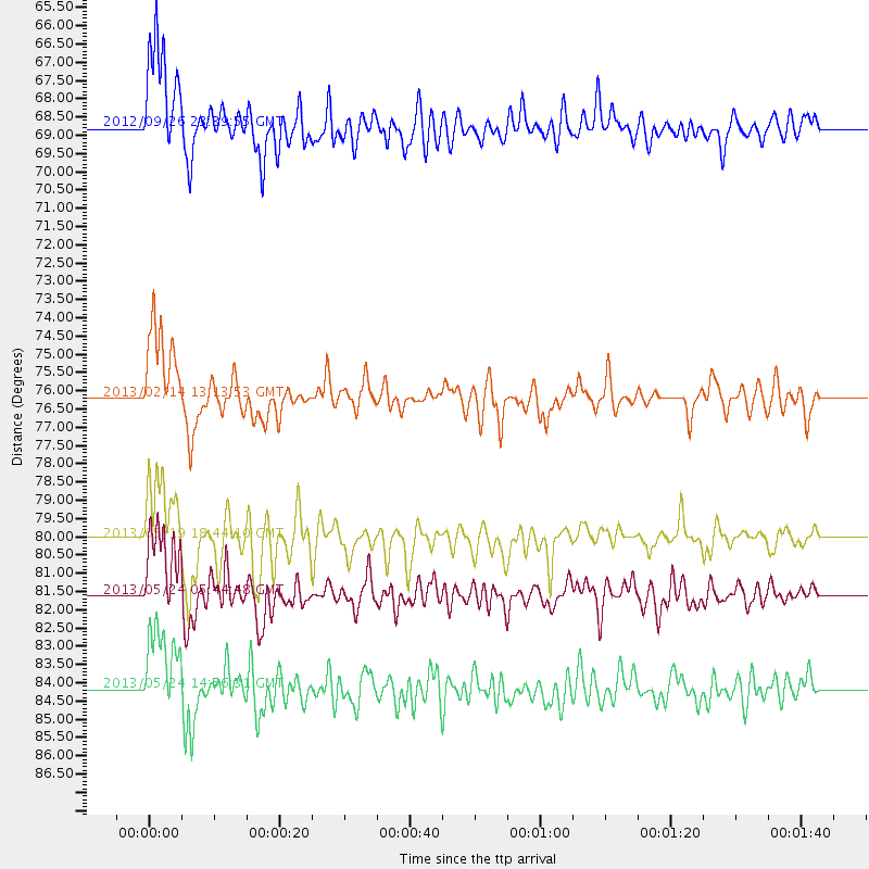
Events Used in the Stack
(5 events)| Radial Match | Distance | Baz | FERegion | Time | Lat/Lon | Depth | Magnitude |
| 97.533936 | 81.6 deg | 330.131 deg | Sea Of Okhotsk | 2013/05/24 05:44:48 GMT | (54.9, 153.2) | 598 km | 8.4 MW, 7.5 MB, 8.3 MW |
| 89.77921 | 68.8 deg | 318.063 deg | Andreanof Islands, Aleutian Is. | 2012/09/26 23:39:55 GMT | (51.6, -178.3) | 16 km | 6.3 MB, 6.5 MS, 6.4 MW, 6.4 MW |
| 86.767426 | 84.2 deg | 328.874 deg | Sea Of Okhotsk | 2013/05/24 14:56:31 GMT | (52.2, 151.4) | 624 km | 6.7 MW, 6.7 MB, 6.7 MW |
| 86.079285 | 76.2 deg | 343.022 deg | Eastern Siberia, Russia | 2013/02/14 13:13:53 GMT | (67.6, 142.5) | 11 km | 6.5 MB, 6.7 MS, 6.6 MW, 6.7 MW |
| 86.07469 | 80.0 deg | 325.515 deg | Off East Coast Of Kamchatka | 2013/05/19 18:44:10 GMT | (52.3, 160.1) | 18 km | 6.1 MW, 5.8 MS, 5.9 MB, 5.9 MW |
Losers
(24 events)| Radial Match | Distance | Baz | FERegion | Time | Lat/Lon | Depth | Magnitude | Reason |
| 92.26962 | 88.6 deg | 324.808 deg | Kuril Islands | 2013/04/19 03:05:52 GMT | (46.2, 150.8) | 110 km | 7.2 MW, 7.1 MB, 7.2 MW | |
| 88.21067 | 49.9 deg | 160.281 deg | Peru-Bolivia Border Region | 2012/05/14 10:00:40 GMT | (-17.7, -69.6) | 106 km | 6.4 MB, 6.2 MW, 6.2 MW | |
| 85.33932 | 39.8 deg | 162.779 deg | Peru-Brazil Border Region | 2012/08/02 09:38:30 GMT | (-8.4, -74.3) | 145 km | 5.9 MB, 6.1 MW, 6.1 MW | |
| 83.44796 | 59.6 deg | 164.99 deg | Central Chile | 2013/01/30 20:15:43 GMT | (-28.1, -70.7) | 45 km | 6.5 MB, 6.5 MS, 6.8 MW, 6.8 MW | |
| 80.123604 | 88.9 deg | 324.044 deg | Kuril Islands | 2012/07/08 11:33:02 GMT | (45.5, 151.3) | 20 km | 5.7 MB, 5.6 MS, 6.0 MW, 5.8 MW | |
| 77.697365 | 82.2 deg | 325.441 deg | Kuril Islands | 2013/03/01 13:20:49 GMT | (51.0, 157.4) | 29 km | 6.3 MB, 6.3 MS, 6.5 MW, 6.4 MW | |
| 76.92559 | 89.1 deg | 169.418 deg | Drake Passage | 2012/04/14 10:56:19 GMT | (-57.7, -65.3) | 15 km | 6.1 MB, 6.1 MS, 6.2 MW, 6.2 MW | |
| 74.3673 | 83.9 deg | 324.857 deg | Kuril Islands | 2012/07/20 06:10:25 GMT | (49.4, 155.9) | 19 km | 5.7 MB, 5.7 MS, 6.0 MW, 6.1 MW | |
| 72.94981 | 40.7 deg | 316.616 deg | Queen Charlotte Islands Region | 2012/10/28 19:09:53 GMT | (52.3, -132.1) | 10 km | 5.6 MB, 5.8 MW, 5.5 MW | |
| 72.45017 | 82.3 deg | 325.489 deg | Kuril Islands | 2013/02/28 14:05:50 GMT | (51.0, 157.3) | 41 km | 6.4 MB, 6.7 MS, 6.9 MW, 6.8 MW | |
| 71.31708 | 61.5 deg | 157.647 deg | Santiago Del Estero Prov., Arg. | 2013/02/22 12:01:58 GMT | (-27.9, -63.1) | 575 km | 5.8 MB, 6.1 MW, 6.2 MW | |
| 69.8543 | 79.9 deg | 325.473 deg | Off East Coast Of Kamchatka | 2013/05/21 03:05:50 GMT | (52.4, 160.3) | 11 km | 5.9 MW, 5.5 MB, 5.8 MS, 5.8 MW | |
| 68.89624 | 73.6 deg | 322.508 deg | Near Islands, Aleutian Islands | 2012/06/19 15:56:32 GMT | (53.4, 171.6) | 14 km | 6.2 MB, 5.7 MS, 6.0 MW, 6.1 MW | |
| 68.67818 | 98.2 deg | 322.866 deg | Off East Coast Of Honshu, Japan | 2012/12/07 08:31:14 GMT | (37.9, 143.8) | 32 km | 6.1 MB, 6.2 MW, 6.2 MW | |
| 65.60022 | 49.9 deg | 64.447 deg | Azores Islands Region | 2013/04/30 06:25:23 GMT | (37.6, -24.9) | 10 km | 5.8 MW, 5.9 MW, 5.9 MB | |
| 65.22447 | 37.5 deg | 310.465 deg | Off Coast Of Washington | 2012/08/19 08:07:35 GMT | (47.8, -128.6) | 10 km | 5.6 MW, 5.3 MS, 5.2 MB, 5.5 MW | |
| 62.1413 | 45.3 deg | 166.722 deg | Near Coast Of Peru | 2012/07/02 23:31:37 GMT | (-14.4, -75.6) | 40 km | 6.0 MB, 5.2 MS, 5.7 MW, 5.6 MW | |
| 60.347145 | 42.9 deg | 320.538 deg | Southeastern Alaska | 2013/01/05 08:58:19 GMT | (55.4, -134.7) | 10 km | 6.4 MB, 7.7 MS, 7.5 MW, 7.5 MW | |
| 58.9237 | 56.6 deg | 155.83 deg | Salta Province, Argentina | 2012/11/22 13:07:10 GMT | (-22.7, -63.6) | 517 km | 5.6 MB, 5.9 MW, 6.0 MW | |
| 58.798443 | 57.3 deg | 164.185 deg | Near Coast Of Northern Chile | 2012/05/19 08:35:10 GMT | (-25.7, -70.6) | 28 km | 5.7 MB, 5.5 MS, 5.8 MW, 5.9 MW | |
| 56.02646 | 45.4 deg | 162.093 deg | Central Peru | 2013/05/21 23:02:45 GMT | (-13.8, -72.3) | 92 km | 5.8 MW, 5.7 MB, 5.8 MW | |
| 55.175777 | 54.1 deg | 160.248 deg | Chile-Bolivia Border Region | 2012/10/08 01:50:26 GMT | (-21.7, -68.2) | 122 km | 6.0 MB, 5.7 MW, 5.8 MW | |
| 54.73942 | 68.7 deg | 318.12 deg | Andreanof Islands, Aleutian Is. | 2013/04/21 13:48:29 GMT | (51.7, -178.2) | 44 km | 5.6 MW, 5.7 MW, 5.9 MB | |
| 43.86367 | 36.1 deg | 303.736 deg | Off Coast Of Oregon | 2012/04/11 22:41:46 GMT | (43.6, -127.6) | 8.0 km | 5.8 MB, 5.9 MS, 6.0 MW |
