
Station TA A06A - Chilliwack, BC, Canada
Network: TA - USArray Transportable Network (new EarthScope stations)
Nearby stations (2 deg radius)
| Station | Name | (Lat, Lon) | Start / End | Elevation |
| A06A | Chilliwack, BC, Canada | (49.10, -121.48) | 2006-10-18 / 2499-01-01 | 0.6 km |
| Crust2 Type: | L8,thin continental arc, Cordilleras, 0.5 km seds. |
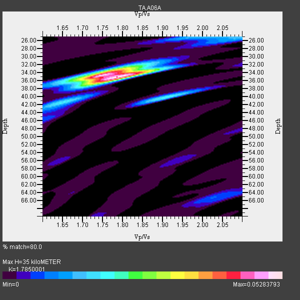
| Thickness Estimate: | 35 km |
| Thickness StdDev: | 0.3 km |
| Vp/Vs Estimate: | 1.79 |
| Vp/Vs StdDev: | 0.02 |
| Vs Estimate: | 3.679 km/s |
| Poisson's Ratio: | 0.27 |
| Peak Value: | 0.05 |
| Assumed Vp: | 6.566 km/s |
| Ps Weight: | 0.33333334 |
| PpPs Weight: | 0.33333334 |
| PsPs Weight: | 0.33333328 |
| Residual Complexity: | 0.472 |
| Nearby stations H: | +- |
| (2.0 deg) Vp/Vs: | +- |
7 with match > 90% ( 24.137932 %) and 17 with match > 80% ( 58.62069 %) out of 29.
Download stack as xyz text file.
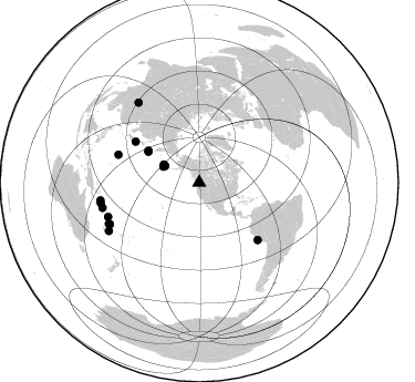
Azimuth Distribution of Events:
Prior Results for this Station
| Study | Thickness | Vp/Vs | Vp | Vs | Poissons Ratio | Extra |
| EARS | 35 km | 1.79 | 6.566 km/s | 3.679 km/s | 0.27 | |
| Crust2.0 | 34 km | 1.77 | 6.566 km/s | 3.707 km/s | 0.27 | L8,thin continental arc, Cordilleras, 0.5 km seds. |
| Global Maxima | 35 km | 1.79 | 6.566 km/s | 3.679 km/s | 0.27 | amp=0.05283793 |
| Local Maxima 1 | 34 km | 1.76 | 6.566 km/s | 3.736 km/s | 0.26 | amp=0.033631925 |
| Local Maxima 2 | 40 km | 1.91 | 6.566 km/s | 3.438 km/s | 0.31 | amp=0.019266402 |
| Local Maxima 3 | 25 km | 1.97 | 6.566 km/s | 3.329 km/s | 0.33 | amp=0.014789369 |
| Local Maxima 4 | 25 km | 2.10 | 6.566 km/s | 3.13 km/s | 0.35 | amp=0.0106674265 |
| Predicted Arrivals for vertical incidence (zero ray parameter) | |
| Ps | 4.18 SECOND |
| PpPs | 14.85 SECOND |
| PsPs/PpSs | 19.03 SECOND |
Events Processed for this Station
Download zip of receiver functions as SAC
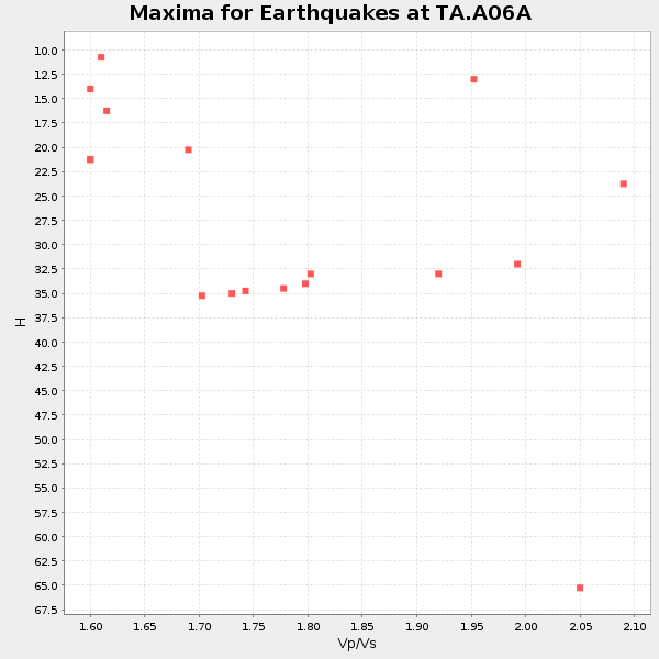
Plot maxima for each earthquake.
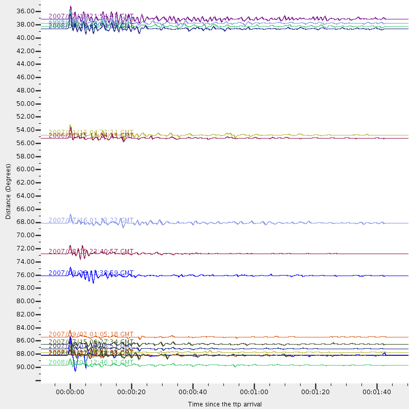
Events Used in the Stack
(17 events)| Radial Match | Distance | Baz | FERegion | Time | Lat/Lon | Depth | Magnitude |
| 97.81635 | 87.7 deg | 249.477 deg | Santa Cruz Islands | 2007/09/02 01:05:18 GMT | (-11.6, 165.8) | 35 km | 5.9 MB, 7.3 MS, 7.2 MW, 6.9 ME |
| 96.70505 | 90.8 deg | 258.077 deg | Solomon Islands | 2007/04/01 20:39:56 GMT | (-8.5, 157.0) | 10 km | 6.8 MB, 7.9 MS, 8.1 MW, 7.7 ME |
| 96.20583 | 54.3 deg | 302.211 deg | Kuril Islands | 2006/11/15 11:14:13 GMT | (46.6, 153.3) | 10 km | 6.5 MB, 7.8 MS, 8.3 MW, 7.9 MW |
| 93.84735 | 53.8 deg | 301.229 deg | East Of Kuril Islands | 2007/01/13 04:23:21 GMT | (46.2, 154.5) | 10 km | 7.3 MB, 8.2 MS, 8.1 MW, 7.9 MW |
| 92.83039 | 92.4 deg | 241.883 deg | Loyalty Islands | 2008/04/09 12:46:12 GMT | (-20.1, 168.9) | 33 km | 6.3 MB, 7.3 MS, 7.3 MW, 7.3 MW |
| 90.999825 | 90.8 deg | 259.803 deg | Solomon Islands | 2007/04/01 21:11:33 GMT | (-7.3, 155.7) | 10 km | 6.3 MB |
| 90.07581 | 88.9 deg | 244.981 deg | Vanuatu Islands | 2007/07/15 09:27:34 GMT | (-15.4, 168.6) | 8.0 km | 6.0 MB, 5.8 MS, 6.1 MW, 6.0 MW |
| 89.53027 | 89.6 deg | 245.545 deg | Vanuatu Islands | 2007/08/01 17:08:51 GMT | (-15.6, 167.7) | 120 km | 6.2 MB, 7.2 MW, 7.2 MW |
| 89.24512 | 73.7 deg | 134.336 deg | Near Coast Of Peru | 2007/08/15 23:40:57 GMT | (-13.4, -76.6) | 39 km | 6.7 MB, 7.9 MS, 8.0 MW, 7.5 ME |
| 87.65142 | 90.3 deg | 255.372 deg | Solomon Islands | 2007/08/16 08:39:27 GMT | (-9.8, 159.5) | 10 km | 6.1 MB, 6.7 MS, 6.4 MW |
| 86.67395 | 90.8 deg | 322.761 deg | Sichuan, China | 2008/05/12 06:28:01 GMT | (31.0, 103.3) | 19 km | 6.9 MB, 8.1 MS, 7.9 MW, 7.9 MW |
| 86.20564 | 35.5 deg | 293.821 deg | Andreanof Islands, Aleutian Is. | 2007/08/15 20:22:11 GMT | (50.3, -177.5) | 9.0 km | 6.3 MB, 6.2 MS, 6.4 MW, 5.9 ML |
| 83.99106 | 77.4 deg | 288.916 deg | Volcano Islands, Japan Region | 2007/09/28 13:38:59 GMT | (22.0, 142.7) | 276 km | 6.7 MB, 7.4 MW, 7.4 MW |
| 83.48245 | 34.3 deg | 295.876 deg | Andreanof Islands, Aleutian Is. | 2007/07/13 21:54:43 GMT | (51.8, -176.3) | 35 km | 5.7 MB, 5.6 MS, 6.0 MW, 5.9 MW |
| 80.98772 | 35.0 deg | 296.338 deg | Andreanof Islands, Aleutian Is. | 2008/05/02 01:33:37 GMT | (51.9, -177.5) | 14 km | 6.3 MB, 6.8 MS, 6.6 MW, 6.6 MW |
| 80.6023 | 36.0 deg | 296.918 deg | Andreanof Islands, Aleutian Is. | 2008/04/16 05:54:19 GMT | (51.9, -179.2) | 13 km | 6.1 MB, 6.5 MS, 6.6 MW, 6.6 MW |
| 80.44975 | 68.5 deg | 302.755 deg | Near West Coast Of Honshu, Japan | 2007/07/16 01:13:22 GMT | (37.5, 138.4) | 12 km | 6.5 MB, 6.4 MS, 6.6 MW, 6.5 MW |
Losers
(12 events)| Radial Match | Distance | Baz | FERegion | Time | Lat/Lon | Depth | Magnitude | Reason |
| 85.3466 | 92.4 deg | 241.942 deg | Vanuatu Islands | 2008/04/09 14:47:50 GMT | (-20.0, 168.9) | 35 km | 5.9 MB, 6.2 MS, 6.3 MW | |
| 83.854706 | 84.1 deg | 282.188 deg | South Of Mariana Islands | 2008/05/09 21:51:29 GMT | (12.5, 143.2) | 76 km | 6.1 MB, 6.7 MW, 6.7 MW | |
| 76.652336 | 94.4 deg | 295.938 deg | Philippine Islands Region | 2008/03/03 14:11:14 GMT | (13.4, 125.6) | 24 km | 6.4 MB, 6.9 MW, 6.8 MW | |
| 71.01573 | 67.8 deg | 299.821 deg | Near East Coast Of Honshu, Japan | 2008/05/07 16:45:20 GMT | (36.2, 141.5) | 39 km | 6.1 MB, 6.7 MS, 6.8 MW, 6.8 MW | |
| 62.323425 | 92.6 deg | 241.688 deg | Loyalty Islands | 2008/04/10 01:10:02 GMT | (-20.3, 168.9) | 35 km | 5.5 MB, 5.5 MS, 5.8 MW | |
| 60.995712 | 43.6 deg | 133.631 deg | Near Coast Of Guatemala | 2008/04/15 03:03:04 GMT | (13.6, -90.6) | 33 km | 5.6 MB, 5.8 MS, 6.1 MW, 6.1 MW | |
| 58.34924 | 90.6 deg | 245.204 deg | Vanuatu Islands | 2008/03/12 11:23:34 GMT | (-16.6, 167.3) | 13 km | 5.8 MB, 6.4 MS, 6.4 MW, 6.4 MW | |
| 58.17718 | 92.5 deg | 241.804 deg | Loyalty Islands | 2008/04/09 11:23:40 GMT | (-20.2, 168.9) | 35 km | 5.7 MB, 6.3 MW, 6.3 MW | |
| 53.807003 | 90.7 deg | 260.724 deg | Solomon Islands | 2008/05/03 19:01:46 GMT | (-6.6, 155.1) | 35 km | 5.8 MW, 5.4 MS, 5.4 MB, 5.7 MW | |
| 51.79466 | 63.8 deg | 303.667 deg | Hokkaido, Japan Region | 2008/04/29 05:26:04 GMT | (41.5, 142.0) | 47 km | 5.5 MB, 5.2 MS, 5.8 MW, 5.8 MW | |
| 49.697815 | 73.8 deg | 292.412 deg | Bonin Islands, Japan Region | 2008/03/14 22:32:09 GMT | (27.0, 142.6) | 11 km | 5.7 MB, 5.9 MS, 6.0 MW, 6.0 MW | |
| 47.12583 | 83.2 deg | 131.286 deg | Chile-Bolivia Border Region | 2008/03/24 20:39:07 GMT | (-20.0, -69.0) | 120 km | 5.7 MB, 6.2 MW, 6.1 MW |
