
Station TA C12A - Trout Creek, MT, USA
Network: TA - USArray Transportable Network (new EarthScope stations)
Nearby stations (2 deg radius)
| Station | Name | (Lat, Lon) | Start / End | Elevation |
| C12A | Trout Creek, MT, USA | (47.70, -115.48) | 2006-09-22 / 2499-01-01 | 0.8 km |
| Crust2 Type: | H2,early/mid Proter. shield, Finland, no seds. |
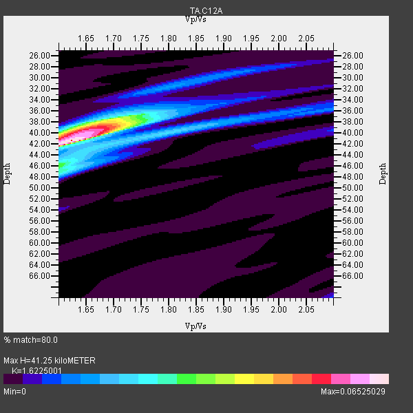
| Thickness Estimate: | 41 km |
| Thickness StdDev: | 1.0 km |
| Vp/Vs Estimate: | 1.62 |
| Vp/Vs StdDev: | 0.02 |
| Vs Estimate: | 4.081 km/s |
| Poisson's Ratio: | 0.19 |
| Peak Value: | 0.07 |
| Assumed Vp: | 6.622 km/s |
| Ps Weight: | 0.33333334 |
| PpPs Weight: | 0.33333334 |
| PsPs Weight: | 0.33333328 |
| Residual Complexity: | 0.622 |
| Nearby stations H: | 40 km +- 2.1 km |
| (2.0 deg) Vp/Vs: | 1.66 +- 0.06 |
2 with match > 90% ( 50.0 %) and 4 with match > 80% ( 100.0 %) out of 4.
Download stack as xyz text file.
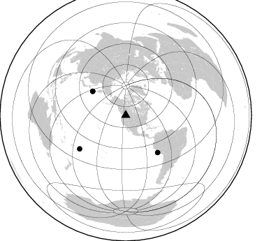
Azimuth Distribution of Events:
Prior Results for this Station
| Study | Thickness | Vp/Vs | Vp | Vs | Poissons Ratio | Extra |
| EARS | 41 km | 1.62 | 6.622 km/s | 4.081 km/s | 0.19 | |
| Crust2.0 | 45 km | 1.78 | 6.622 km/s | 3.729 km/s | 0.27 | H2,early/mid Proter. shield, Finland, no seds. |
| Global Maxima | 41 km | 1.62 | 6.622 km/s | 4.081 km/s | 0.19 | amp=0.06525029 |
| Local Maxima 1 | 39 km | 1.66 | 6.622 km/s | 3.983 km/s | 0.22 | amp=0.044547096 |
| Local Maxima 2 | 47 km | 1.60 | 6.622 km/s | 4.132 km/s | 0.18 | amp=0.024186749 |
| Local Maxima 3 | 37 km | 1.70 | 6.622 km/s | 3.89 km/s | 0.24 | amp=0.020086143 |
| Local Maxima 4 | 40 km | 1.77 | 6.622 km/s | 3.736 km/s | 0.27 | amp=0.017002977 |
| Predicted Arrivals for vertical incidence (zero ray parameter) | |
| Ps | 3.88 SECOND |
| PpPs | 16.34 SECOND |
| PsPs/PpSs | 20.21 SECOND |
Events Processed for this Station
Download zip of receiver functions as SAC
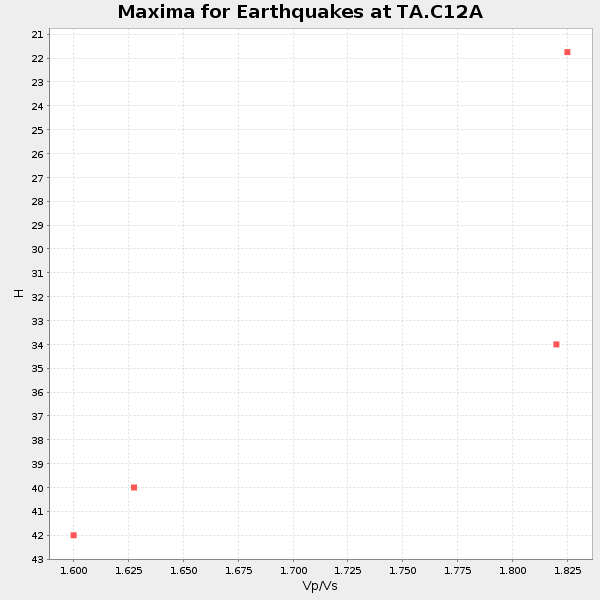
Plot maxima for each earthquake.
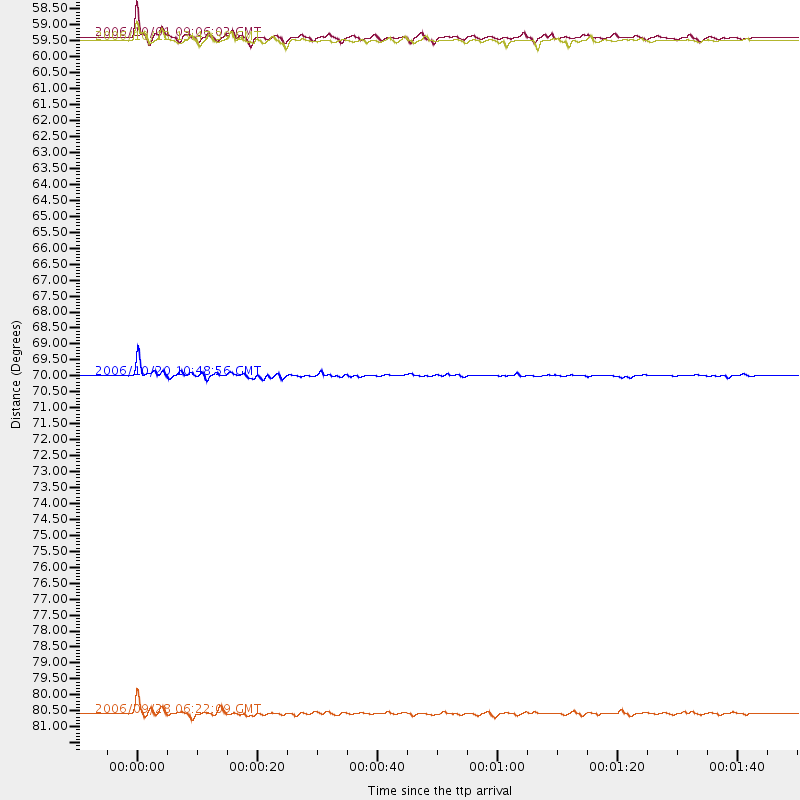
Events Used in the Stack
(4 events)| Radial Match | Distance | Baz | FERegion | Time | Lat/Lon | Depth | Magnitude |
| 96.60834 | 81.5 deg | 233.994 deg | Samoa Islands Region | 2006/09/28 06:22:09 GMT | (-16.6, -172.0) | 28 km | 6.5 MB, 6.6 MS, 6.9 MW, 6.7 MW |
| 92.52816 | 58.5 deg | 305.863 deg | Kuril Islands | 2006/10/01 09:06:02 GMT | (46.5, 153.2) | 19 km | 6.1 MB, 6.4 MS, 6.6 MW, 6.5 MW |
| 89.084984 | 70.0 deg | 139.557 deg | Near Coast Of Peru | 2006/10/20 10:48:56 GMT | (-13.5, -76.7) | 23 km | 5.9 MB, 6.6 MS, 6.7 MW, 6.6 MW |
| 88.83882 | 58.6 deg | 305.641 deg | Kuril Islands | 2006/10/13 13:47:39 GMT | (46.3, 153.3) | 8.0 km | 5.5 MB, 5.8 MS, 6.3 MW, 5.8 MW |
Losers
(0 events)| Radial Match | Distance | Baz | FERegion | Time | Lat/Lon | Depth | Magnitude | Reason |
