
Station TA H02A - Toledo, OR, USA
Network: TA - USArray Transportable Network (new EarthScope stations)
Nearby stations (2 deg radius)
| Station | Name | (Lat, Lon) | Start / End | Elevation |
| H02A | Toledo, OR, USA | (44.68, -124.00) | 2005-11-15 / 2499-01-01 | 0.2 km |
| Crust2 Type: | L8,thin continental arc, Cordilleras, 0.5 km seds. |
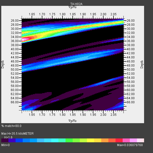
| Thickness Estimate: | 36 km |
| Thickness StdDev: | 3.3 km |
| Vp/Vs Estimate: | 1.60 |
| Vp/Vs StdDev: | 0.16 |
| Vs Estimate: | 4.104 km/s |
| Poisson's Ratio: | 0.18 |
| Peak Value: | 0.04 |
| Assumed Vp: | 6.566 km/s |
| Ps Weight: | 0.33333334 |
| PpPs Weight: | 0.33333334 |
| PsPs Weight: | 0.33333328 |
| Residual Complexity: | 0.797 |
| Nearby stations H: | +- |
| (2.0 deg) Vp/Vs: | +- |
2 with match > 90% ( 33.333332 %) and 6 with match > 80% ( 100.0 %) out of 6.
Download stack as xyz text file.
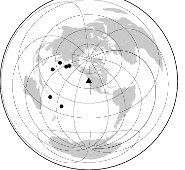
Azimuth Distribution of Events:
Prior Results for this Station
| Study | Thickness | Vp/Vs | Vp | Vs | Poissons Ratio | Extra |
| EARS | 36 km | 1.60 | 6.566 km/s | 4.104 km/s | 0.18 | |
| Crust2.0 | 34 km | 1.77 | 6.566 km/s | 3.707 km/s | 0.27 | L8,thin continental arc, Cordilleras, 0.5 km seds. |
| Global Maxima | 36 km | 1.60 | 6.566 km/s | 4.104 km/s | 0.18 | amp=0.036079768 |
| Local Maxima 1 | 29 km | 1.87 | 6.566 km/s | 3.507 km/s | 0.30 | amp=0.025920847 |
| Local Maxima 2 | 34 km | 1.61 | 6.566 km/s | 4.091 km/s | 0.18 | amp=0.01850227 |
| Local Maxima 3 | 31 km | 1.60 | 6.566 km/s | 4.104 km/s | 0.18 | amp=0.015434251 |
| Local Maxima 4 | 27 km | 2.08 | 6.566 km/s | 3.164 km/s | 0.35 | amp=0.01281011 |
| Predicted Arrivals for vertical incidence (zero ray parameter) | |
| Ps | 3.24 SECOND |
| PpPs | 14.06 SECOND |
| PsPs/PpSs | 17.30 SECOND |
Events Processed for this Station
Download zip of receiver functions as SAC
Plot maxima for each earthquake.
Events Used in the Stack
(6 events)| Radial Match | Distance | Baz | FERegion | Time | Lat/Lon | Depth | Magnitude |
| 93.3532 | 54.7 deg | 302.755 deg | East Of Kuril Islands | 2007/01/13 04:23:21 GMT | (46.2, 154.5) | 10 km | 7.3 MB, 8.2 MS, 8.1 MW, 7.9 MW |
| 90.02037 | 75.0 deg | 227.567 deg | Samoa Islands Region | 2006/09/28 06:22:09 GMT | (-16.6, -172.0) | 28 km | 6.5 MB, 6.6 MS, 6.9 MW, 6.7 MW |
| 88.50899 | 77.2 deg | 288.153 deg | Volcano Islands, Japan Region | 2007/09/28 13:38:59 GMT | (22.0, 142.7) | 276 km | 6.7 MB, 7.4 MW, 7.4 MW |
| 85.645546 | 84.5 deg | 247.881 deg | Santa Cruz Islands | 2007/09/02 01:05:18 GMT | (-11.6, 165.8) | 35 km | 5.9 MB, 7.3 MS, 7.2 MW, 6.9 ME |
| 83.63965 | 69.5 deg | 302.707 deg | Near West Coast Of Honshu, Japan | 2007/07/16 01:13:22 GMT | (37.5, 138.4) | 12 km | 6.5 MB, 6.4 MS, 6.6 MW, 6.5 MW |
| 82.35739 | 50.4 deg | 308.295 deg | Kamchatka Peninsula, Russia | 2007/05/30 20:22:12 GMT | (52.1, 157.3) | 116 km | 6.4 MB, 6.4 MW, 6.4 MW |
Losers
(0 events)| Radial Match | Distance | Baz | FERegion | Time | Lat/Lon | Depth | Magnitude | Reason |
