
Station TA I02E - Swisshome, OR, USA
Network: TA - USArray Transportable Network (new EarthScope stations)
Nearby stations (2 deg radius)
| Station | Name | (Lat, Lon) | Start / End | Elevation |
| I02E | Swisshome, OR, USA | (44.11, -123.85) | 2015-10-24 / 2016-09-30 | 117 m |
| Crust2 Type: | L8,thin continental arc, Cordilleras, 0.5 km seds. |
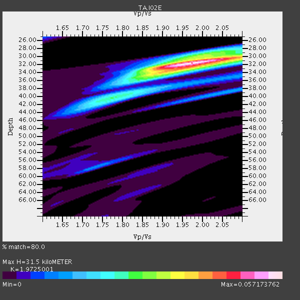
| Thickness Estimate: | 32 km |
| Thickness StdDev: | 1.5 km |
| Vp/Vs Estimate: | 1.97 |
| Vp/Vs StdDev: | 0.05 |
| Vs Estimate: | 3.329 km/s |
| Poisson's Ratio: | 0.33 |
| Peak Value: | 0.06 |
| Assumed Vp: | 6.566 km/s |
| Ps Weight: | 0.33333334 |
| PpPs Weight: | 0.33333334 |
| PsPs Weight: | 0.33333328 |
| Residual Complexity: | 0.492 |
| Nearby stations H: | 32 km +- 0.7 km |
| (2.0 deg) Vp/Vs: | 1.91 +- 0.01 |
0 with match > 90% ( 0.0 %) and 4 with match > 80% ( 8.695652 %) out of 46.
Download stack as xyz text file.
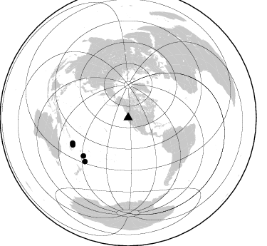
Azimuth Distribution of Events:
Prior Results for this Station
| Study | Thickness | Vp/Vs | Vp | Vs | Poissons Ratio | Extra |
| EARS | 32 km | 1.97 | 6.566 km/s | 3.329 km/s | 0.33 | |
| Crust2.0 | 34 km | 1.77 | 6.566 km/s | 3.707 km/s | 0.27 | L8,thin continental arc, Cordilleras, 0.5 km seds. |
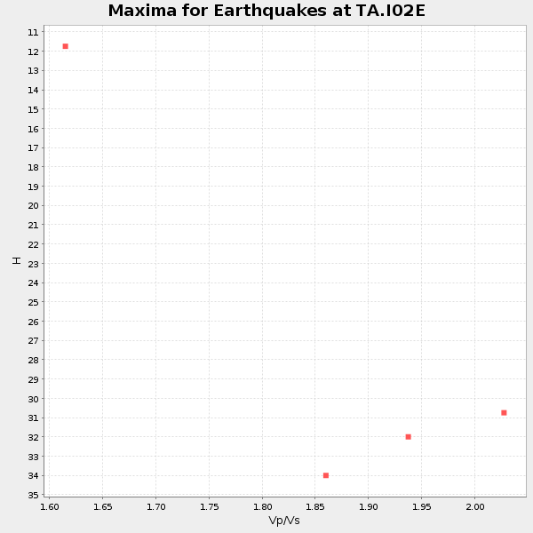
| Global Maxima | 32 km | 1.97 | 6.566 km/s | 3.329 km/s | 0.33 | amp=0.057173762 |
| Local Maxima 1 | 34 km | 1.89 | 6.566 km/s | 3.47 km/s | 0.31 | amp=0.02762671 |
| Local Maxima 2 | 40 km | 1.80 | 6.566 km/s | 3.648 km/s | 0.28 | amp=0.016308412 |
| Local Maxima 3 | 30 km | 1.99 | 6.566 km/s | 3.308 km/s | 0.33 | amp=0.0147961825 |
| Local Maxima 4 | 38 km | 2.09 | 6.566 km/s | 3.145 km/s | 0.35 | amp=0.013955665 |
| Predicted Arrivals for vertical incidence (zero ray parameter) | |
| Ps | 4.67 SECOND |
| PpPs | 14.26 SECOND |
| PsPs/PpSs | 18.93 SECOND |
Events Processed for this Station
Download zip of receiver functions as SAC
Plot maxima for each earthquake.
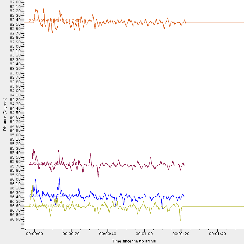
Events Used in the Stack
(4 events)| Radial Match | Distance | Baz | FERegion | Time | Lat/Lon | Depth | Magnitude |
| 89.592155 | 86.4 deg | 224.674 deg | Kermadec Islands Region | 2016/07/13 12:11:13 GMT | (-28.0, -176.4) | 12 km | 6.3 MWB |
| 87.78142 | 86.6 deg | 243.885 deg | Vanuatu Islands | 2016/04/28 19:33:27 GMT | (-16.1, 167.3) | 35 km | 7.0 MO |
| 85.19177 | 85.7 deg | 245.425 deg | Vanuatu Islands | 2016/04/03 08:23:53 GMT | (-14.4, 166.8) | 35 km | 6.9 MWW, 7.2 MI |
| 81.19817 | 82.5 deg | 229.487 deg | South Of Fiji Islands | 2016/05/28 05:38:51 GMT | (-22.0, -178.2) | 417 km | 6.6 MO |
Losers
(42 events)| Radial Match | Distance | Baz | FERegion | Time | Lat/Lon | Depth | Magnitude | Reason |
| 96.49791 | 77.8 deg | 283.885 deg | Mariana Islands | 2016/07/29 21:18:25 GMT | (18.5, 145.5) | 212 km | 7.7 MWW, 7.7 MWB, 7.7 MI | |
| 83.69488 | 88.6 deg | 137.133 deg | Near Coast Of Central Chile | 2015/11/07 07:31:42 GMT | (-30.9, -71.5) | 36 km | 6.8 MWP, 6.8 MI | |
| 79.555855 | 85.6 deg | 245.766 deg | Vanuatu Islands | 2016/04/06 06:58:48 GMT | (-14.1, 166.6) | 24 km | 6.7 MWW, 6.6 MWB, 6.7 MWC, 6.9 MI | |
| 77.53634 | 30.0 deg | 142.631 deg | Off Coast Of Jalisco, Mexico | 2016/06/07 10:51:38 GMT | (18.4, -105.2) | 10 km | 6.2 MWP | |
| 76.948746 | 58.5 deg | 125.174 deg | Near Coast Of Ecuador | 2016/05/18 16:46:44 GMT | (0.5, -79.6) | 31 km | 6.8 MO | |
| 74.48238 | 85.8 deg | 253.79 deg | Solomon Islands | 2016/06/10 04:17:44 GMT | (-8.7, 160.5) | 28 km | 6.2 MWW | |
| 73.87536 | 72.5 deg | 124.706 deg | Peru-Brazil Border Region | 2015/11/24 22:45:38 GMT | (-10.6, -71.0) | 602 km | 7.5 MWW, 6.9 MI | |
| 73.43684 | 85.6 deg | 132.568 deg | Northern Chile | 2016/06/24 21:29:18 GMT | (-25.7, -69.3) | 122 km | 5.5 MB | |
| 70.40084 | 72.0 deg | 124.494 deg | Peru-Brazil Border Region | 2015/11/24 22:50:53 GMT | (-10.1, -71.1) | 595 km | 5.9 MB | |
| 69.5716 | 33.9 deg | 142.99 deg | Off Coast Of Guerrero, Mexico | 2016/07/23 08:52:02 GMT | (14.9, -103.5) | 45 km | 5.5 MB | |
| 69.17983 | 44.3 deg | 123.182 deg | Near Coast Of Nicaragua | 2016/06/10 03:25:22 GMT | (12.8, -87.0) | 10 km | 6.1 MWP | |
| 67.90769 | 87.9 deg | 304.111 deg | Taiwan Region | 2016/05/31 05:23:47 GMT | (25.6, 122.5) | 243 km | 6.1 MO | |
| 67.601364 | 86.6 deg | 243.826 deg | Vanuatu Islands | 2016/06/30 11:30:34 GMT | (-16.1, 167.4) | 40 km | 5.8 MB | |
| 66.83373 | 82.0 deg | 237.756 deg | Fiji Islands Region | 2015/12/09 12:58:01 GMT | (-16.6, 175.3) | 10 km | 5.7 MB | |
| 65.134094 | 58.1 deg | 125.668 deg | Near Coast Of Ecuador | 2016/04/20 08:33:48 GMT | (0.6, -80.3) | 16 km | 6.1 MO | |
| 64.38483 | 88.0 deg | 240.428 deg | Vanuatu Islands | 2016/04/18 13:06:11 GMT | (-19.5, 169.0) | 74 km | 5.9 MO | |
| 63.688206 | 85.6 deg | 245.845 deg | Vanuatu Islands | 2016/04/07 03:32:53 GMT | (-14.0, 166.6) | 27 km | 6.7 MWW, 6.5 MWB, 6.9 MI | |
| 63.267994 | 49.4 deg | 310.582 deg | Kamchatka Peninsula, Russia | 2016/01/30 03:25:10 GMT | (54.0, 158.5) | 161 km | 7.2 MWW, 7.0 MI, 7.2 MWB | |
| 62.20831 | 75.7 deg | 130.361 deg | Near Coast Of Peru | 2016/02/16 10:46:27 GMT | (-16.4, -73.5) | 13 km | 5.7 MWW, 5.6 MWB, 5.7 MWC | |
| 61.10511 | 35.2 deg | 132.907 deg | Oaxaca, Mexico | 2016/05/08 07:34:02 GMT | (16.6, -97.7) | 24 km | 5.9 MB | |
| 60.217476 | 58.8 deg | 307.846 deg | Northwest Of Kuril Islands | 2016/07/23 01:00:21 GMT | (47.7, 147.0) | 407 km | 5.7 MB | |
| 60.142803 | 88.7 deg | 240.14 deg | Loyalty Islands | 2016/06/20 03:50:55 GMT | (-20.2, 168.8) | 15 km | 6.0 MWW, 5.8 MWB, 5.9 MWC, 6.0 MWC | |
| 60.127834 | 77.6 deg | 303.798 deg | Kyushu, Japan | 2016/04/15 16:45:56 GMT | (32.9, 130.8) | 10 km | 5.7 MB | |
| 59.65771 | 85.2 deg | 133.733 deg | Near Coast Of Northern Chile | 2016/07/25 17:26:49 GMT | (-26.1, -70.6) | 68 km | 6.2 MB | |
| 59.63267 | 85.2 deg | 234.035 deg | South Of Fiji Islands | 2016/01/18 18:24:17 GMT | (-21.5, 176.2) | 4.7 km | 5.8 MWW, 5.8 MWB, 5.9 MWC | |
| 59.62818 | 35.2 deg | 133.109 deg | Oaxaca, Mexico | 2016/06/27 20:50:34 GMT | (16.6, -97.8) | 19 km | 5.7 MWW, 5.5 MWB | |
| 58.76069 | 86.4 deg | 127.795 deg | Jujuy Province, Argentina | 2015/11/29 18:52:49 GMT | (-23.5, -64.6) | 9.6 km | 5.9 MWP | |
| 57.947994 | 71.2 deg | 124.103 deg | Peru-Brazil Border Region | 2015/11/26 05:45:18 GMT | (-9.2, -71.3) | 604 km | 6.4 MWP | |
| 57.78542 | 88.4 deg | 137.204 deg | Near Coast Of Central Chile | 2015/12/08 12:56:07 GMT | (-30.8, -71.7) | 30 km | 5.6 MB | |
| 57.580097 | 44.0 deg | 125.977 deg | Off Coast Of Central America | 2016/03/19 10:24:45 GMT | (11.9, -88.8) | 10 km | 5.6 MWC, 5.6 MWC, 5.6 MWW | |
| 57.390663 | 39.5 deg | 128.569 deg | Near Coast Of Chiapas, Mexico | 2016/04/27 12:51:22 GMT | (14.6, -93.0) | 35 km | 5.8 MB | |
| 56.74863 | 87.9 deg | 235.654 deg | Southeast Of Loyalty Islands | 2016/05/16 00:41:53 GMT | (-22.5, 173.0) | 10 km | 5.8 MWW, 5.7 MWB, 5.8 MWC | |
| 56.738796 | 88.5 deg | 259.334 deg | Solomon Islands | 2016/02/08 16:19:13 GMT | (-6.6, 154.7) | 32 km | 6.4 MWW, 6.3 MWB, 6.7 MI | |
| 56.539925 | 88.4 deg | 137.032 deg | Near Coast Of Central Chile | 2016/02/10 00:33:05 GMT | (-30.6, -71.6) | 32 km | 6.3 MWB | |
| 56.03425 | 85.5 deg | 130.006 deg | Chile-Argentina Border Region | 2016/06/18 17:29:44 GMT | (-24.2, -67.1) | 167 km | 5.5 MB | |
| 56.02084 | 89.3 deg | 303.72 deg | Taiwan | 2016/04/27 15:17:14 GMT | (24.2, 121.8) | 13 km | 5.5 MWW, 5.4 MWR, 5.5 MWB, 5.6 MWC | |
| 54.379253 | 75.9 deg | 232.514 deg | Fiji Islands Region | 2015/12/01 17:08:25 GMT | (-14.9, -176.6) | 10 km | 5.6 MB | |
| 52.91897 | 65.1 deg | 95.721 deg | North Atlantic Ocean | 2016/04/20 10:51:39 GMT | (13.2, -55.9) | 10 km | 5.8 MB | |
| 52.667942 | 87.6 deg | 240.814 deg | Vanuatu Islands | 2016/07/20 15:13:16 GMT | (-18.9, 169.0) | 164 km | 6.0 MO | |
| 52.614803 | 90.9 deg | 152.498 deg | West Chile Rise | 2015/12/25 17:58:04 GMT | (-40.7, -86.4) | 10 km | 5.8 MWW, 5.7 MWC, 5.7 MWB | |
| 48.084816 | 74.3 deg | 229.991 deg | Tonga Islands | 2016/07/23 20:09:19 GMT | (-15.1, -173.6) | 10 km | 5.7 MB | |
| 44.644543 | 81.8 deg | 230.585 deg | Fiji Islands Region | 2016/05/27 04:08:44 GMT | (-20.8, -178.7) | 572 km | 6.4 MO |

