
Station TA S10A - Tonopah Range, Tonopah, NV, USA
Network: TA - USArray Transportable Network (new EarthScope stations)
Nearby stations (2 deg radius)
| Station | Name | (Lat, Lon) | Start / End | Elevation |
| S10A | Tonopah Range, Tonopah, NV, USA | (37.92, -116.59) | 2007-01-22 / 2499-01-01 | 1.8 km |
| Crust2 Type: | M7,medium thick extended crust, 0.5 km seds. |
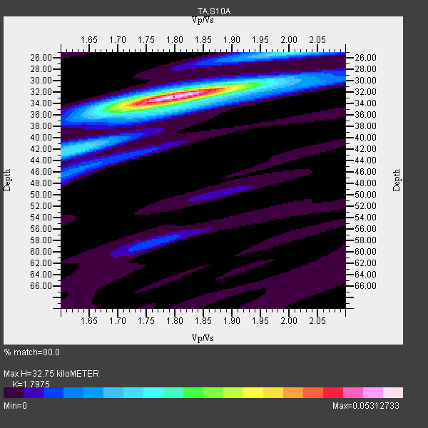
| Thickness Estimate: | 33 km |
| Thickness StdDev: | 0.3 km |
| Vp/Vs Estimate: | 1.80 |
| Vp/Vs StdDev: | 0.01 |
| Vs Estimate: | 3.493 km/s |
| Poisson's Ratio: | 0.28 |
| Peak Value: | 0.05 |
| Assumed Vp: | 6.279 km/s |
| Ps Weight: | 0.33333334 |
| PpPs Weight: | 0.33333334 |
| PsPs Weight: | 0.33333328 |
| Residual Complexity: | 0.371 |
| Nearby stations H: | +- |
| (2.0 deg) Vp/Vs: | +- |
14 with match > 90% ( 36.842106 %) and 38 with match > 80% ( 100.0 %) out of 38.
Download stack as xyz text file.
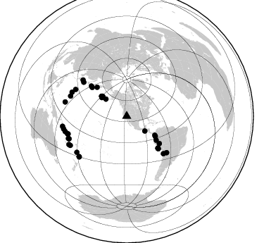
Azimuth Distribution of Events:
Prior Results for this Station
| Study | Thickness | Vp/Vs | Vp | Vs | Poissons Ratio | Extra |
| EARS | 33 km | 1.80 | 6.279 km/s | 3.493 km/s | 0.28 | |
| Crust2.0 | 35 km | 1.78 | 6.279 km/s | 3.533 km/s | 0.27 | M7,medium thick extended crust, 0.5 km seds. |
| Global Maxima | 33 km | 1.80 | 6.279 km/s | 3.493 km/s | 0.28 | amp=0.05312733 |
| Local Maxima 1 | 25 km | 2.00 | 6.279 km/s | 3.139 km/s | 0.33 | amp=0.018019296 |
| Local Maxima 2 | 42 km | 1.63 | 6.279 km/s | 3.846 km/s | 0.20 | amp=0.015242535 |
| Local Maxima 3 | 35 km | 1.74 | 6.279 km/s | 3.603 km/s | 0.25 | amp=0.0118810935 |
| Local Maxima 4 | 31 km | 1.89 | 6.279 km/s | 3.313 km/s | 0.31 | amp=0.0109077515 |
| Predicted Arrivals for vertical incidence (zero ray parameter) | |
| Ps | 4.16 SECOND |
| PpPs | 14.59 SECOND |
| PsPs/PpSs | 18.75 SECOND |
Events Processed for this Station
Download zip of receiver functions as SAC
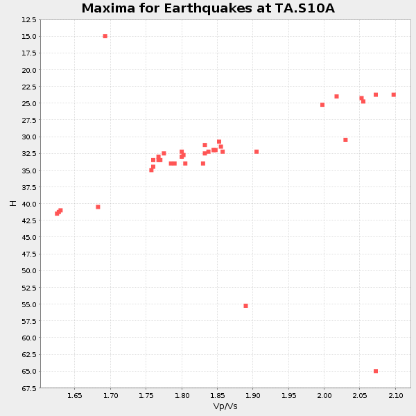
Plot maxima for each earthquake.
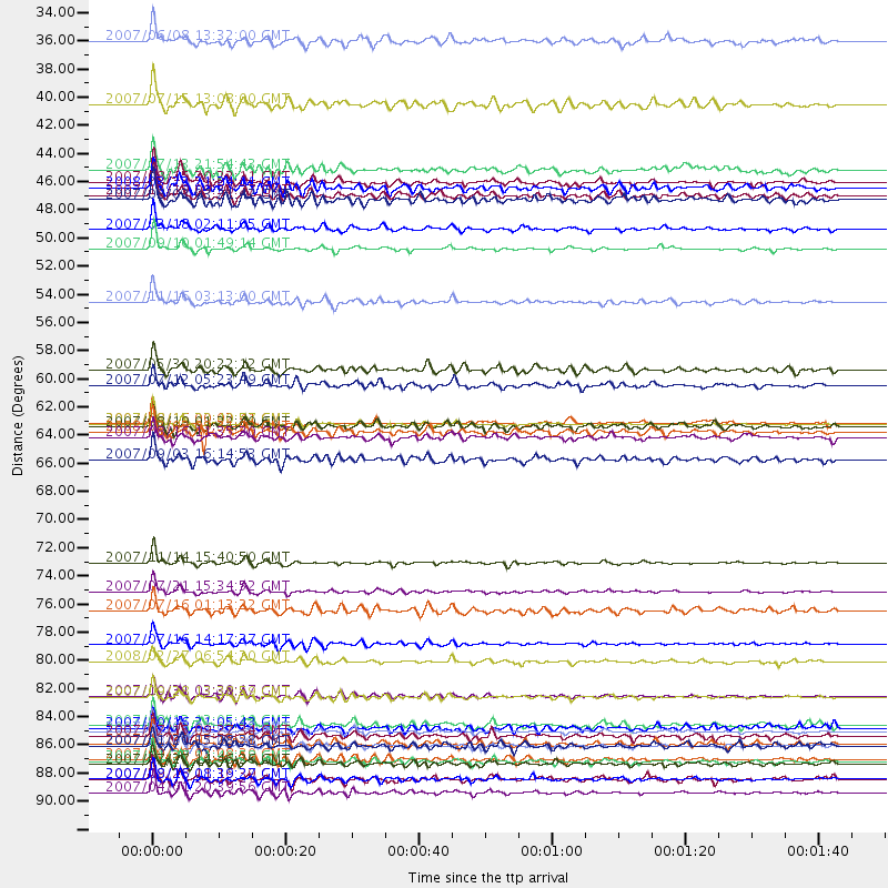
Events Used in the Stack
(38 events)| Radial Match | Distance | Baz | FERegion | Time | Lat/Lon | Depth | Magnitude |
| 96.987175 | 87.5 deg | 253.338 deg | Santa Cruz Islands | 2007/09/02 01:05:18 GMT | (-11.6, 165.8) | 35 km | 5.9 MB, 7.3 MS, 7.2 MW, 6.9 ME |
| 96.79296 | 74.2 deg | 135.515 deg | Northern Chile | 2007/11/14 15:40:50 GMT | (-22.2, -69.9) | 40 km | 6.7 MB, 7.4 MS, 7.7 MW, 7.4 ME |
| 96.41551 | 63.3 deg | 135.581 deg | Near Coast Of Peru | 2007/08/15 23:40:57 GMT | (-13.4, -76.6) | 39 km | 6.7 MB, 7.9 MS, 8.0 MW, 7.5 ME |
| 95.50286 | 92.3 deg | 261.133 deg | Solomon Islands | 2007/04/01 20:39:56 GMT | (-8.5, 157.0) | 10 km | 6.8 MB, 7.9 MS, 8.1 MW, 7.7 ME |
| 95.23985 | 53.7 deg | 129.113 deg | Peru-Ecuador Border Region | 2007/11/16 03:13:00 GMT | (-2.3, -77.8) | 123 km | 6.3 MB, 6.8 MW, 6.7 MW |
| 95.0757 | 87.8 deg | 248.687 deg | Vanuatu Islands | 2007/07/15 09:27:34 GMT | (-15.4, 168.6) | 8.0 km | 6.0 MB, 5.8 MS, 6.1 MW, 6.0 MW |
| 94.65496 | 91.2 deg | 258.587 deg | Solomon Islands | 2007/08/16 08:39:27 GMT | (-9.8, 159.5) | 10 km | 6.1 MB, 6.7 MS, 6.4 MW |
| 94.10769 | 49.6 deg | 125.006 deg | Near West Coast Of Colombia | 2007/09/10 01:49:14 GMT | (3.0, -78.0) | 31 km | 6.1 MB, 6.7 MS, 6.8 MW |
| 93.931175 | 89.6 deg | 282.891 deg | South Of Mariana Islands | 2007/09/30 02:08:30 GMT | (10.5, 145.7) | 14 km | 6.4 MB, 7.1 MS, 6.9 MW, 6.9 MW |
| 93.145355 | 88.6 deg | 249.095 deg | Vanuatu Islands | 2007/08/01 17:08:51 GMT | (-15.6, 167.7) | 120 km | 6.2 MB, 7.2 MW, 7.2 MW |
| 92.94094 | 84.8 deg | 293.719 deg | Volcano Islands, Japan Region | 2007/09/28 13:38:59 GMT | (22.0, 142.7) | 276 km | 6.7 MB, 7.4 MW, 7.4 MW |
| 90.14859 | 77.9 deg | 308.246 deg | Near West Coast Of Honshu, Japan | 2007/07/16 01:13:22 GMT | (37.5, 138.4) | 12 km | 6.5 MB, 6.4 MS, 6.6 MW, 6.5 MW |
| 90.13318 | 88.5 deg | 229.787 deg | Kermadec Islands, New Zealand | 2007/01/31 03:15:52 GMT | (-29.8, -178.0) | 34 km | 6.1 MB, 6.3 MS, 6.5 MW, 6.4 MW |
| 90.0573 | 38.2 deg | 309.363 deg | Fox Islands, Aleutian Islands | 2007/07/15 13:08:00 GMT | (52.5, -168.0) | 10 km | 5.8 MB, 5.9 MS, 6.1 MW, 6.0 MW |
| 89.98123 | 45.4 deg | 308.338 deg | Andreanof Islands, Aleutian Is. | 2007/12/19 09:30:27 GMT | (51.4, -179.5) | 29 km | 6.4 MB, 7.1 MS, 7.1 MW, 7.0 MW |
| 89.831215 | 48.0 deg | 124.163 deg | South Of Panama | 2007/03/18 02:11:05 GMT | (4.6, -78.5) | 8.0 km | 6.4 MB, 5.7 MS, 6.2 MW, 6.1 MW |
| 89.21304 | 63.3 deg | 135.396 deg | Near Coast Of Peru | 2007/08/16 00:02:41 GMT | (-13.3, -76.5) | 40 km | 5.6 MB |
| 89.050476 | 59.0 deg | 314.162 deg | Kamchatka Peninsula, Russia | 2007/05/30 20:22:12 GMT | (52.1, 157.3) | 116 km | 6.4 MB, 6.4 MW, 6.4 MW |
| 88.92417 | 87.2 deg | 234.146 deg | South Of Fiji Islands | 2007/10/16 21:05:43 GMT | (-25.8, 179.5) | 509 km | 6.2 MB, 6.6 MW, 6.5 MW |
| 88.81077 | 44.8 deg | 309.383 deg | Andreanof Islands, Aleutian Is. | 2008/03/22 21:24:11 GMT | (52.2, -178.7) | 132 km | 5.8 MB, 6.2 MW, 6.1 MW |
| 88.6242 | 33.2 deg | 129.365 deg | Near Coast Of Guatemala | 2007/06/08 13:32:00 GMT | (13.8, -90.8) | 48 km | 5.5 MB, 5.4 MS, 5.8 MW, 5.8 MW |
| 88.58092 | 80.6 deg | 309.54 deg | Sea Of Japan | 2007/07/16 14:17:37 GMT | (36.8, 134.9) | 350 km | 6.2 MB, 6.8 MW, 6.8 MW |
| 88.08627 | 84.7 deg | 289.699 deg | Mariana Islands | 2007/10/31 03:30:17 GMT | (18.9, 145.4) | 223 km | 6.2 MB, 7.2 MW, 7.2 MW |
| 87.83196 | 63.5 deg | 135.745 deg | Near Coast Of Peru | 2007/08/19 01:22:40 GMT | (-13.6, -76.6) | 26 km | 5.9 MB, 5.4 MS, 5.8 MW, 5.5 ML |
| 87.68385 | 43.3 deg | 308.663 deg | Andreanof Islands, Aleutian Is. | 2007/07/13 21:54:43 GMT | (51.8, -176.3) | 35 km | 5.7 MB, 5.6 MS, 6.0 MW, 5.9 MW |
| 87.39748 | 76.5 deg | 132.346 deg | Jujuy Province, Argentina | 2007/07/21 15:34:52 GMT | (-22.2, -65.8) | 290 km | 5.8 MB, 6.4 MW, 6.3 MW |
| 86.91749 | 90.0 deg | 242.652 deg | Southeast Of Loyalty Islands | 2007/07/27 14:46:26 GMT | (-21.5, 170.9) | 10 km | 6.0 MB, 6.0 MS, 6.1 MW, 6.1 MW |
| 86.16972 | 66.1 deg | 310.23 deg | Kuril Islands | 2007/09/03 16:14:53 GMT | (45.8, 150.1) | 94 km | 6.3 MB, 6.2 MW, 6.2 ME |
| 86.1687 | 81.9 deg | 297.613 deg | Bonin Islands, Japan Region | 2008/02/27 06:54:20 GMT | (26.8, 142.4) | 15 km | 5.8 MB, 6.1 MS, 6.2 MW, 6.2 MW |
| 86.14833 | 89.9 deg | 256.077 deg | Solomon Islands | 2007/11/27 11:49:58 GMT | (-10.9, 162.1) | 16 km | 5.9 MB, 6.7 MS, 6.6 MW, 6.4 MW |
| 85.41712 | 45.7 deg | 308.319 deg | Andreanof Islands, Aleutian Is. | 2007/08/02 03:21:42 GMT | (51.3, -180.0) | 21 km | 6.3 MB, 6.6 MS, 6.7 MW, 6.6 MW |
| 83.90433 | 88.6 deg | 229.563 deg | Kermadec Islands, New Zealand | 2007/11/20 15:28:28 GMT | (-30.0, -177.9) | 59 km | 6.0 MB, 5.9 MW, 5.8 MW |
| 83.09046 | 63.9 deg | 309.609 deg | Kuril Islands | 2008/03/03 09:31:02 GMT | (46.4, 153.2) | 10 km | 6.2 MB, 6.5 MS, 6.5 MW, 6.5 MW |
| 82.26498 | 87.0 deg | 253.198 deg | Santa Cruz Islands | 2007/08/12 12:05:19 GMT | (-11.4, 166.3) | 42 km | 5.8 MB, 5.7 MS, 6.0 MW, 6.0 MW |
| 81.809975 | 91.2 deg | 243.844 deg | Southeast Of Loyalty Islands | 2007/09/28 11:16:39 GMT | (-21.3, 169.1) | 10 km | 5.6 MB, 5.7 MS, 5.9 MW |
| 81.11867 | 64.4 deg | 135.766 deg | Near Coast Of Peru | 2007/08/16 11:35:30 GMT | (-14.3, -76.1) | 35 km | 5.7 MB, 5.5 MS, 6.0 MW, 5.6 ML |
| 80.81055 | 44.3 deg | 306.622 deg | Andreanof Islands, Aleutian Is. | 2007/08/15 20:22:11 GMT | (50.3, -177.5) | 9.0 km | 6.3 MB, 6.2 MS, 6.4 MW, 5.9 ML |
| 80.444244 | 60.2 deg | 129.947 deg | Peru-Brazil Border Region | 2007/07/12 05:23:49 GMT | (-7.9, -74.4) | 152 km | 5.9 MB, 6.1 MW, 6.0 MW |
Losers
(0 events)| Radial Match | Distance | Baz | FERegion | Time | Lat/Lon | Depth | Magnitude | Reason |
