
Station TA V05C - Boulder Hill, Kettleman City, CA, USA
Network: TA - USArray Transportable Network (new EarthScope stations)
Nearby stations (2 deg radius)
| Station | Name | (Lat, Lon) | Start / End | Elevation |
| V05C | Boulder Hill, Kettleman City, CA, USA | (35.87, -119.90) | 2005-04-11 / 2499-01-01 | 0.1 km |
| Crust2 Type: | M1,extended crust, 3 km seds. |
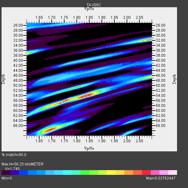
| Thickness Estimate: | 56 km |
| Thickness StdDev: | 6.4 km |
| Vp/Vs Estimate: | 1.75 |
| Vp/Vs StdDev: | 0.10 |
| Vs Estimate: | 3.496 km/s |
| Poisson's Ratio: | 0.26 |
| Peak Value: | 0.04 |
| Assumed Vp: | 6.1 km/s |
| Ps Weight: | 0.33333334 |
| PpPs Weight: | 0.33333334 |
| PsPs Weight: | 0.33333328 |
| Residual Complexity: | 0.835 |
| Nearby stations H: | +- |
| (2.0 deg) Vp/Vs: | +- |
0 with match > 90% ( 0.0 %) and 2 with match > 80% ( 100.0 %) out of 2.
Download stack as xyz text file.
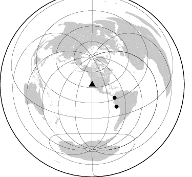
Azimuth Distribution of Events:
Prior Results for this Station
| Study | Thickness | Vp/Vs | Vp | Vs | Poissons Ratio | Extra |
| EARS | 56 km | 1.75 | 6.1 km/s | 3.496 km/s | 0.26 | |
| Crust2.0 | 31 km | 1.78 | 6.1 km/s | 3.426 km/s | 0.27 | M1,extended crust, 3 km seds. |
| Global Maxima | 56 km | 1.75 | 6.1 km/s | 3.496 km/s | 0.26 | amp=0.03762447 |
| Local Maxima 1 | 32 km | 2.10 | 6.1 km/s | 2.908 km/s | 0.35 | amp=0.033738315 |
| Local Maxima 2 | 68 km | 1.69 | 6.1 km/s | 3.604 km/s | 0.23 | amp=0.03182969 |
| Local Maxima 3 | 46 km | 2.10 | 6.1 km/s | 2.908 km/s | 0.35 | amp=0.023510862 |
| Local Maxima 4 | 54 km | 1.85 | 6.1 km/s | 3.302 km/s | 0.29 | amp=0.022043066 |
| Predicted Arrivals for vertical incidence (zero ray parameter) | |
| Ps | 6.87 SECOND |
| PpPs | 25.31 SECOND |
| PsPs/PpSs | 32.18 SECOND |
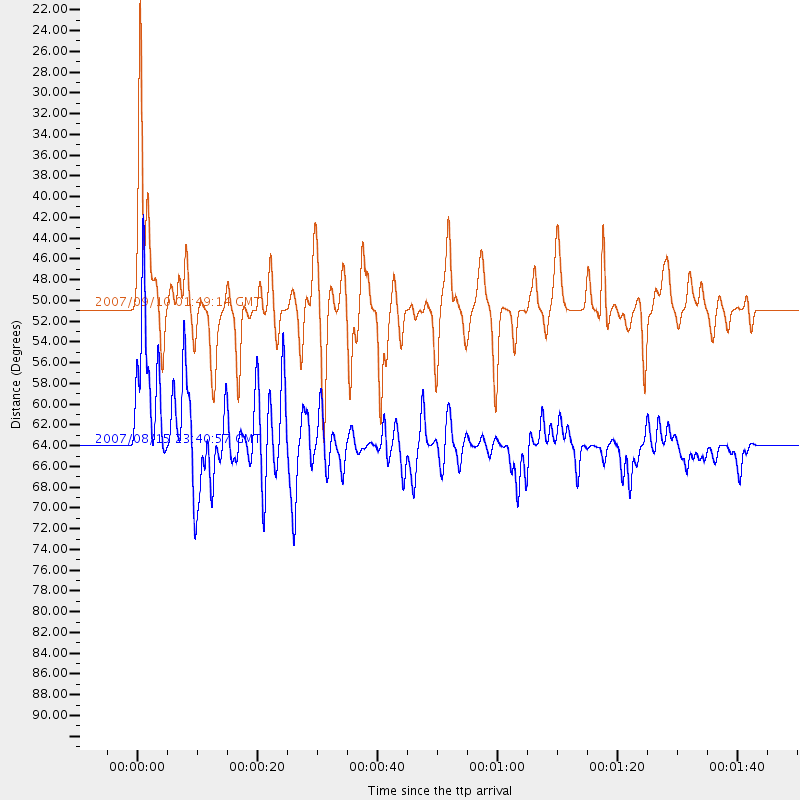
Events Processed for this Station
Download zip of receiver functions as SAC
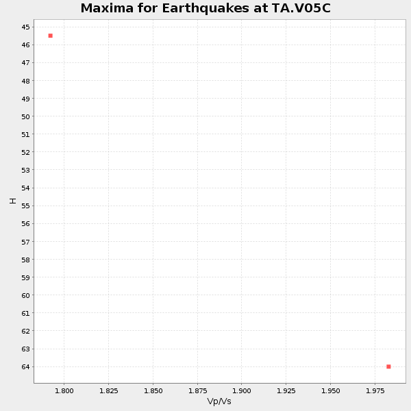
Plot maxima for each earthquake.
Events Used in the Stack
(2 events)| Radial Match | Distance | Baz | FERegion | Time | Lat/Lon | Depth | Magnitude |
| 88.3895 | 63.8 deg | 131.954 deg | Near Coast Of Peru | 2007/08/15 23:40:57 GMT | (-13.4, -76.6) | 39 km | 6.7 MB, 7.9 MS, 8.0 MW, 7.5 ME |
| 81.416756 | 50.7 deg | 120.388 deg | Near West Coast Of Colombia | 2007/09/10 01:49:14 GMT | (3.0, -78.0) | 31 km | 6.1 MB, 6.7 MS, 6.8 MW |
Losers
(0 events)| Radial Match | Distance | Baz | FERegion | Time | Lat/Lon | Depth | Magnitude | Reason |
