
Station TA Y22E - IRIS PASSCAL Instrument Center, Socorro, NM, USA
Network: TA - USArray Transportable Network (new EarthScope stations)
Nearby stations (2 deg radius)
| Station | Name | (Lat, Lon) | Start / End | Elevation |
| Y22E | IRIS PASSCAL Instrument Center, Socorro, NM, USA | (34.07, -106.92) | 2011-03-28 / 2599-12-31 | 1444 m |
| Crust2 Type: | X2,Rift, Rio Grande, Baikal, 0.5km sediments |
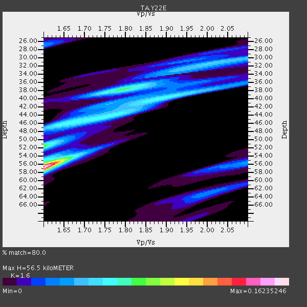
| Thickness Estimate: | 56 km |
| Thickness StdDev: | 11 km |
| Vp/Vs Estimate: | 1.60 |
| Vp/Vs StdDev: | 0.15 |
| Vs Estimate: | 4.063 km/s |
| Poisson's Ratio: | 0.18 |
| Peak Value: | 0.16 |
| Assumed Vp: | 6.502 km/s |
| Ps Weight: | 0.33333334 |
| PpPs Weight: | 0.33333334 |
| PsPs Weight: | 0.33333328 |
| Residual Complexity: | 0.808 |
| Nearby stations H: | 39 km +- 0.0 km |
| (2.0 deg) Vp/Vs: | 1.86 +- 0.01 |
1 with match > 90% ( 4.7619047 %) and 2 with match > 80% ( 9.523809 %) out of 21.
Download stack as xyz text file.
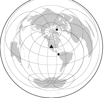
Azimuth Distribution of Events:
Prior Results for this Station
| Study | Thickness | Vp/Vs | Vp | Vs | Poissons Ratio | Extra |
| EARS | 56 km | 1.60 | 6.502 km/s | 4.063 km/s | 0.18 | |
| Crust2.0 | 33 km | 1.77 | 6.502 km/s | 3.68 km/s | 0.26 | X2,Rift, Rio Grande, Baikal, 0.5km sediments |
| Global Maxima | 56 km | 1.60 | 6.502 km/s | 4.063 km/s | 0.18 | amp=0.16235246 |
| Local Maxima 1 | 38 km | 1.79 | 6.502 km/s | 3.627 km/s | 0.27 | amp=0.07621215 |
| Local Maxima 2 | 52 km | 1.60 | 6.502 km/s | 4.063 km/s | 0.18 | amp=0.07208838 |
| Local Maxima 3 | 40 km | 1.89 | 6.502 km/s | 3.445 km/s | 0.30 | amp=0.05963178 |
| Local Maxima 4 | 44 km | 1.74 | 6.502 km/s | 3.731 km/s | 0.25 | amp=0.056562547 |
| Predicted Arrivals for vertical incidence (zero ray parameter) | |
| Ps | 5.21 SECOND |
| PpPs | 22.59 SECOND |
| PsPs/PpSs | 27.81 SECOND |
Events Processed for this Station
Download zip of receiver functions as SAC
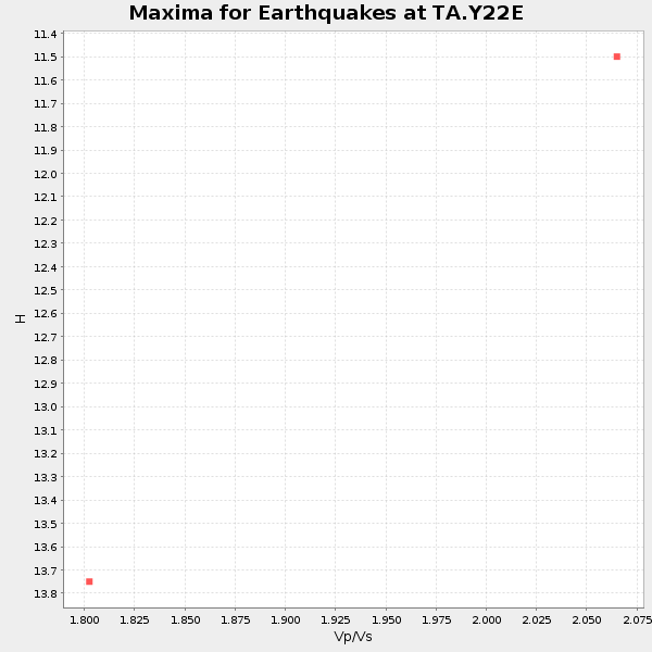
Plot maxima for each earthquake.
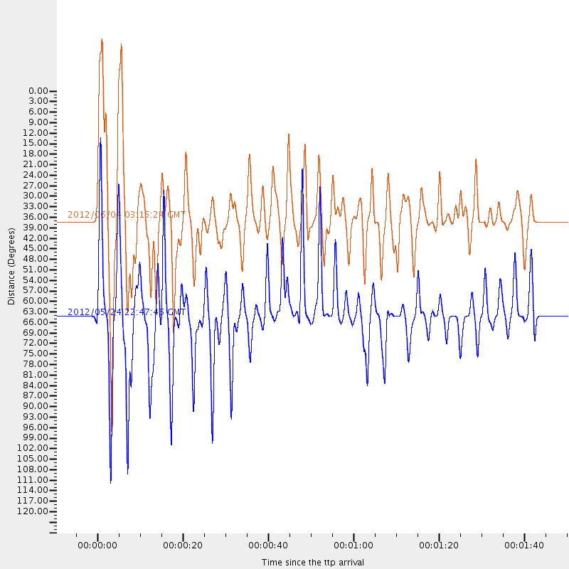
Events Used in the Stack
(2 events)| Radial Match | Distance | Baz | FERegion | Time | Lat/Lon | Depth | Magnitude |
| 91.37946 | 64.0 deg | 17.633 deg | Norwegian Sea | 2012/05/24 22:47:46 GMT | (73.0, 5.7) | 10 km | 5.7 MB, 6.1 MS, 6.1 MW, 6.2 MW |
| 87.16347 | 36.3 deg | 136.097 deg | South Of Panama | 2012/06/04 03:15:24 GMT | (5.5, -82.6) | 7.0 km | 5.8 MB, 5.8 MS, 6.3 MW, 6.1 MW |
Losers
(19 events)| Radial Match | Distance | Baz | FERegion | Time | Lat/Lon | Depth | Magnitude | Reason |
| 90.43975 | 68.8 deg | 144.993 deg | Near Coast Of Northern Chile | 2012/05/19 08:35:10 GMT | (-25.7, -70.6) | 28 km | 5.7 MB, 5.5 MS, 5.8 MW, 5.9 MW | |
| 88.72894 | 62.6 deg | 139.349 deg | Peru-Bolivia Border Region | 2012/05/14 10:00:40 GMT | (-17.7, -69.6) | 106 km | 6.4 MB, 6.2 MW, 6.2 MW | |
| 82.71591 | 80.3 deg | 313.041 deg | Off East Coast Of Honshu, Japan | 2012/03/14 09:08:35 GMT | (40.9, 144.9) | 12 km | 6.7 MB, 6.9 MS, 6.9 MW, 7.0 MW | |
| 78.3342 | 96.5 deg | 253.021 deg | Vanuatu Islands | 2012/02/02 13:34:40 GMT | (-17.8, 167.1) | 23 km | 6.5 MB, 6.9 MS, 7.1 MW, 7.1 MW | |
| 77.40007 | 62.7 deg | 185.6 deg | Easter Island Region | 2012/05/10 02:13:56 GMT | (-28.7, -112.6) | 10 km | 5.8 MS, 5.3 MB, 5.9 MW, 5.8 MW | |
| 77.229744 | 95.3 deg | 250.626 deg | Vanuatu Islands | 2012/03/09 07:09:50 GMT | (-19.1, 169.6) | 16 km | 6.1 MB, 6.7 MS, 6.7 MW, 6.7 MW | |
| 67.908714 | 83.5 deg | 39.113 deg | Northern Italy | 2012/05/20 02:03:52 GMT | (44.9, 11.2) | 6.3 km | 5.8 MB, 6.0 MS, 6.0 MW, 6.1 MW | |
| 63.716568 | 85.5 deg | 244.969 deg | Fiji Islands Region | 2012/02/10 01:47:34 GMT | (-18.0, -178.5) | 582 km | 6.0 MB, 5.9 MW, 6.0 MW | |
| 60.166595 | 86.5 deg | 311.138 deg | Near East Coast Of Honshu, Japan | 2012/04/29 10:28:51 GMT | (35.6, 140.3) | 44 km | 5.6 MB, 5.2 MS, 5.8 MW, 5.8 MW | |
| 59.264614 | 91.9 deg | 241.08 deg | South Of Fiji Islands | 2012/01/24 00:52:05 GMT | (-25.0, 178.5) | 580 km | 5.8 MB, 6.3 MW, 6.4 MW | |
| 57.814636 | 69.4 deg | 137.123 deg | Salta Province, Argentina | 2012/06/02 07:52:53 GMT | (-22.1, -63.6) | 527 km | 5.8 MB, 5.9 MW, 6.0 MW | |
| 55.41898 | 51.7 deg | 311.716 deg | Andreanof Islands, Aleutian Is. | 2012/04/11 09:00:09 GMT | (51.4, -176.1) | 21 km | 5.5 MB, 5.4 ML | |
| 54.37599 | 36.4 deg | 136.384 deg | South Of Panama | 2012/06/04 00:45:15 GMT | (5.3, -82.6) | 7.0 km | 5.9 MB, 5.9 MS, 6.3 MW, 6.2 MW | |
| 54.208374 | 64.4 deg | 140.146 deg | Northern Chile | 2012/04/03 07:25:08 GMT | (-19.6, -69.1) | 117 km | 5.5 ML, 5.2 MB | |
| 52.642582 | 88.8 deg | 239.264 deg | South Of Fiji Islands | 2012/02/26 02:46:21 GMT | (-24.5, -177.5) | 10 km | 5.5 MW, 5.1 MB | |
| 51.721886 | 76.9 deg | 152.497 deg | Near Coast Of Central Chile | 2012/01/23 16:04:52 GMT | (-36.4, -73.0) | 20 km | 5.8 MB, 6.0 MS, 6.1 MW, 6.2 MW | |
| 51.095596 | 82.2 deg | 312.765 deg | Off East Coast Of Honshu, Japan | 2012/05/20 07:19:54 GMT | (39.5, 143.2) | 11 km | 5.6 MB | |
| 49.07855 | 95.1 deg | 233.258 deg | South Of Kermadec Islands | 2011/12/21 13:37:14 GMT | (-33.2, -179.0) | 10 km | 5.6 MB, 5.4 MS, 5.5 MW, 5.7 MW | |
| 47.052784 | 88.8 deg | 242.3 deg | South Of Fiji Islands | 2012/05/29 03:33:25 GMT | (-22.1, -179.6) | 602 km | 5.6 MB, 5.8 MW, 5.9 MW |
