
Station TC ICC1 - Isla del Coco, Costa Rica, Pacific Ocean
Network: TC - Red Sism?logica Nacional de Costa Rica
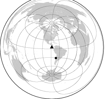
Nearby stations (2 deg radius)
| Station | Name | (Lat, Lon) | Start / End | Elevation |
| ICC1 | Isla del Coco, Costa Rica, Pacific Ocean | (5.54, -87.06) | 2015-06-18 / 2599-12-31 | 10 m |
| Crust2 Type: | B0,melt affected o.c. and oceanic plateaus, 0.10 km seds. |
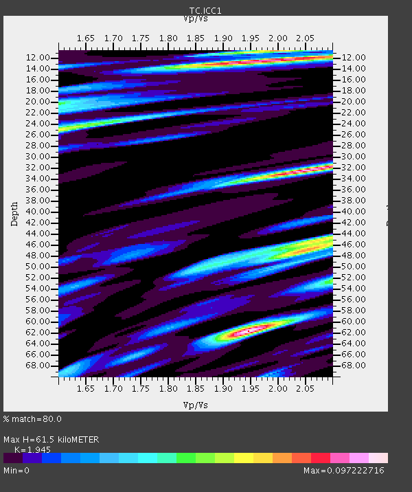
| Thickness Estimate: | 62 km |
| Thickness StdDev: | 21 km |
| Vp/Vs Estimate: | 1.95 |
| Vp/Vs StdDev: | 0.07 |
| Vs Estimate: | 2.469 km/s |
| Poisson's Ratio: | 0.32 |
| Peak Value: | 0.10 |
| Assumed Vp: | 4.802 km/s |
| Ps Weight: | 0.33333334 |
| PpPs Weight: | 0.33333334 |
| PsPs Weight: | 0.33333328 |
| Residual Complexity: | 0.895 |
| Nearby stations H: | +- |
| (2.0 deg) Vp/Vs: | +- |
1 with match > 90% ( 11.111111 %) and 2 with match > 80% ( 22.222221 %) out of 9.
Download stack as xyz text file.
Azimuth Distribution of Events:
Prior Results for this Station
| Study | Thickness | Vp/Vs | Vp | Vs | Poissons Ratio | Extra |
| EARS | 62 km | 1.95 | 4.802 km/s | 2.469 km/s | 0.32 | |
| Crust2.0 | 16 km | 2.06 | 4.802 km/s | 2.335 km/s | 0.35 | B0,melt affected o.c. and oceanic plateaus, 0.10 km seds. |
| Global Maxima | 62 km | 1.95 | 4.802 km/s | 2.469 km/s | 0.32 | amp=0.097222716 |
| Local Maxima 1 | 32 km | 2.05 | 4.802 km/s | 2.342 km/s | 0.34 | amp=0.09072741 |
| Local Maxima 2 | 12 km | 1.95 | 4.802 km/s | 2.463 km/s | 0.32 | amp=0.085409686 |
| Local Maxima 3 | 47 km | 2.05 | 4.802 km/s | 2.342 km/s | 0.34 | amp=0.07214709 |
| Local Maxima 4 | 25 km | 1.61 | 4.802 km/s | 2.992 km/s | 0.18 | amp=0.060315683 |
| Predicted Arrivals for vertical incidence (zero ray parameter) | |
| Ps | 12.10 SECOND |
| PpPs | 37.72 SECOND |
| PsPs/PpSs | 49.82 SECOND |
Events Processed for this Station
Download zip of receiver functions as SAC
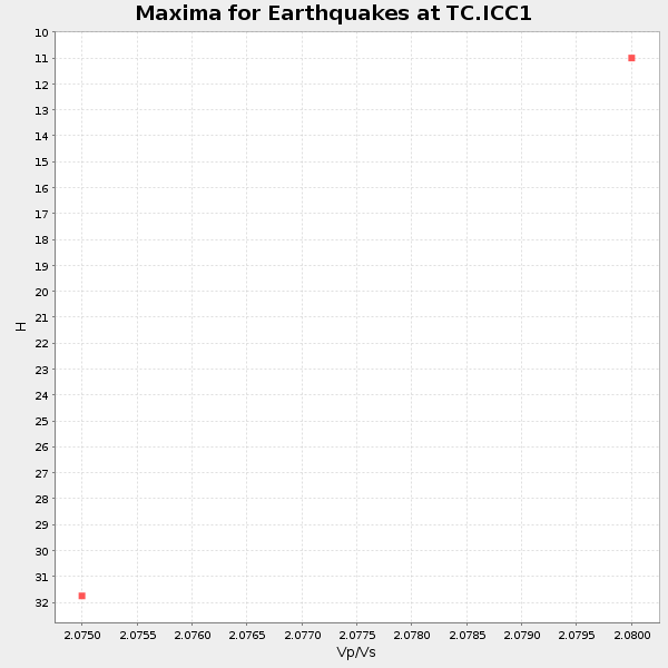
Plot maxima for each earthquake.
Events Used in the Stack
(2 events)| Radial Match | Distance | Baz | FERegion | Time | Lat/Lon | Depth | Magnitude |
| 96.776825 | 39.7 deg | 159.352 deg | Near Coast Of Central Chile | 2015/09/16 22:54:31 GMT | (-31.6, -71.8) | 12 km | 8.3 MWW, 7.9 MI |
| 86.839554 | 39.9 deg | 159.314 deg | Near Coast Of Central Chile | 2015/09/21 17:39:58 GMT | (-31.7, -71.6) | 25 km | 6.5 MB, 6.5 MI, 6.6 MWW |
Losers
(7 events)| Radial Match | Distance | Baz | FERegion | Time | Lat/Lon | Depth | Magnitude | Reason |
| 87.56268 | 42.9 deg | 163.291 deg | Off Coast Of Central Chile | 2015/07/17 11:11:23 GMT | (-35.5, -73.2) | 17 km | 5.3 MW | |
| 75.51985 | 89.4 deg | 248.708 deg | Tonga Islands | 2015/07/06 19:21:05 GMT | (-21.3, -174.3) | 13 km | 5.3 MW | |
| 72.46966 | 39.3 deg | 158.874 deg | Near Coast Of Central Chile | 2015/09/19 09:07:08 GMT | (-31.1, -71.6) | 23 km | 6.1 MWP | |
| 70.132996 | 39.1 deg | 158.403 deg | Near Coast Of Central Chile | 2015/09/26 02:51:18 GMT | (-30.8, -71.4) | 38 km | 6.2 MO | |
| 64.11041 | 38.6 deg | 158.407 deg | Near Coast Of Central Chile | 2015/10/05 16:33:26 GMT | (-30.3, -71.7) | 35 km | 6.0 MB | |
| 58.165573 | 40.0 deg | 159.293 deg | Near Coast Of Central Chile | 2015/09/16 23:03:56 GMT | (-31.8, -71.6) | 10 km | 6.1 MB | |
| 53.597904 | 81.0 deg | 321.716 deg | Fox Islands, Aleutian Islands | 2015/07/28 21:21:33 GMT | (52.1, -169.4) | 12 km | 5.4 MW |

