
Station TC ICR3 - Volcan Irazu Cartago
Network: TC - Red Sism?logica Nacional de Costa Rica
Nearby stations (2 deg radius)
| Station | Name | (Lat, Lon) | Start / End | Elevation |
| ICR3 | Volcan Irazu Cartago | (9.98, -83.84) | 2013-12-10 / 2599-12-31 | 3370 m |
| Crust2 Type: | LA,very thin continental arc, Cordilleras, 1.0 km seds. |
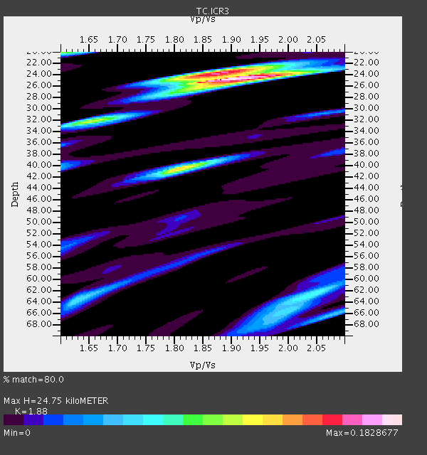
| Thickness Estimate: | 25 km |
| Thickness StdDev: | 0.3 km |
| Vp/Vs Estimate: | 1.88 |
| Vp/Vs StdDev: | 0.02 |
| Vs Estimate: | 3.423 km/s |
| Poisson's Ratio: | 0.30 |
| Peak Value: | 0.18 |
| Assumed Vp: | 6.436 km/s |
| Ps Weight: | 0.33333334 |
| PpPs Weight: | 0.33333334 |
| PsPs Weight: | 0.33333328 |
| Residual Complexity: | 0.560 |
| Nearby stations H: | 44 km +- 24 km |
| (2.0 deg) Vp/Vs: | 1.63 +- 0.05 |
1 with match > 90% ( 3.8461537 %) and 2 with match > 80% ( 7.6923075 %) out of 26.
Download stack as xyz text file.
Azimuth Distribution of Events:

Prior Results for this Station
| Study | Thickness | Vp/Vs | Vp | Vs | Poissons Ratio | Extra |
| EARS | 25 km | 1.88 | 6.436 km/s | 3.423 km/s | 0.30 | |
| Crust2.0 | 25 km | 1.77 | 6.436 km/s | 3.632 km/s | 0.27 | LA,very thin continental arc, Cordilleras, 1.0 km seds. |
| Global Maxima | 25 km | 1.88 | 6.436 km/s | 3.423 km/s | 0.30 | amp=0.1828677 |
| Local Maxima 1 | 40 km | 1.81 | 6.436 km/s | 3.566 km/s | 0.28 | amp=0.12516841 |
| Local Maxima 2 | 24 km | 1.88 | 6.436 km/s | 3.419 km/s | 0.30 | amp=0.109857365 |
| Local Maxima 3 | 20 km | 1.60 | 6.436 km/s | 4.016 km/s | 0.18 | amp=0.09318327 |
| Local Maxima 4 | 32 km | 1.64 | 6.436 km/s | 3.918 km/s | 0.21 | amp=0.08197161 |
| Predicted Arrivals for vertical incidence (zero ray parameter) | |
| Ps | 3.38 SECOND |
| PpPs | 11.08 SECOND |
| PsPs/PpSs | 14.46 SECOND |
Events Processed for this Station
Download zip of receiver functions as SAC
Plot maxima for each earthquake.
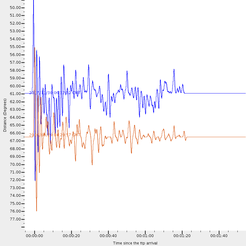
Events Used in the Stack
(2 events)| Radial Match | Distance | Baz | FERegion | Time | Lat/Lon | Depth | Magnitude |
| 91.86437 | 66.4 deg | 94.432 deg | North Of Ascension Island | 2016/08/29 04:29:57 GMT | (-0.0, -17.8) | 10 km | 7.1 MWW, 7.1 MWC, 7.4 MI |
| 80.01339 | 61.0 deg | 96.825 deg | Central Mid-Atlantic Ridge | 2017/11/30 06:32:52 GMT | (-1.1, -23.5) | 10 km | 6.5 Mi |
Losers
(24 events)| Radial Match | Distance | Baz | FERegion | Time | Lat/Lon | Depth | Magnitude | Reason |
| 89.98616 | 46.8 deg | 168.738 deg | Near Coast Of Central Chile | 2015/03/18 19:07:48 GMT | (-36.1, -73.7) | 10 km | 5.4 MW, 5.2 mb, 5.1 MS | |
| 79.474915 | 42.3 deg | 164.231 deg | Near Coast Of Central Chile | 2015/11/07 07:31:42 GMT | (-30.9, -71.5) | 36 km | 6.8 MWP, 6.8 MI | |
| 78.58355 | 53.7 deg | 171.549 deg | Southern Chile | 2016/12/25 14:22:28 GMT | (-43.3, -74.5) | 15 km | 7.7 Mi | |
| 77.304474 | 43.1 deg | 164.719 deg | Near Coast Of Central Chile | 2015/09/21 17:39:58 GMT | (-31.7, -71.6) | 25 km | 6.5 MB, 6.5 MI, 6.6 MWW | |
| 70.46587 | 80.5 deg | 151.303 deg | South Sandwich Islands Region | 2016/04/19 05:25:39 GMT | (-55.6, -27.2) | 11 km | 5.9 MB | |
| 69.794174 | 97.5 deg | 328.172 deg | Kamchatka Peninsula, Russia | 2016/01/30 03:25:10 GMT | (54.0, 158.5) | 161 km | 7.2 MWW, 7.0 MI, 7.2 MWB | |
| 69.53642 | 42.5 deg | 164.406 deg | Near Coast Of Central Chile | 2015/09/19 09:07:08 GMT | (-31.1, -71.6) | 23 km | 6.1 MWP | |
| 69.46226 | 94.1 deg | 329.706 deg | Near East Coast Of Kamchatka | 2017/03/29 04:09:24 GMT | (56.9, 162.7) | 23 km | 6.6 Mww | |
| 69.03702 | 68.0 deg | 326.675 deg | Gulf Of Alaska | 2018/01/23 09:31:42 GMT | (56.0, -149.1) | 25 km | 7.9 Mww | |
| 67.744095 | 31.6 deg | 153.113 deg | Northern Chile | 2015/03/23 04:51:37 GMT | (-18.4, -69.4) | 128 km | 6.1 MWP, 6.1 MO | |
| 66.77162 | 60.8 deg | 28.678 deg | Reykjanes Ridge | 2017/09/10 21:40:21 GMT | (57.1, -33.7) | 10 km | 5.9 Mww | |
| 66.47084 | 83.3 deg | 155.219 deg | South Sandwich Islands Region | 2015/04/30 10:19:08 GMT | (-60.4, -26.8) | 10 km | 5.8 MB | |
| 65.44371 | 35.9 deg | 145.668 deg | Southern Bolivia | 2016/01/14 03:25:28 GMT | (-19.8, -63.3) | 582 km | 6.1 MWW, 6.1 MWB | |
| 65.198975 | 42.5 deg | 164.838 deg | Near Coast Of Central Chile | 2015/09/17 04:02:10 GMT | (-31.2, -71.9) | 16 km | 5.7 mwr | |
| 63.993313 | 82.4 deg | 152.643 deg | South Sandwich Islands Region | 2017/09/04 08:07:35 GMT | (-57.8, -25.6) | 35 km | 6.0 Mww | |
| 63.33566 | 67.7 deg | 327.385 deg | Gulf Of Alaska | 2018/01/23 23:21:27 GMT | (56.6, -148.1) | 12 km | 5.3 Mww | |
| 62.383198 | 80.7 deg | 151.936 deg | South Sandwich Islands Region | 2016/07/31 11:33:20 GMT | (-56.3, -27.5) | 98 km | 5.9 MWW, 5.9 MWC, 5.9 MWB | |
| 61.61397 | 56.4 deg | 50.075 deg | Azores Islands, Portugal | 2015/04/30 06:29:57 GMT | (38.6, -29.1) | 10 km | 4.7 MW, 4.6 mb, 3.7 MS | |
| 59.512024 | 31.9 deg | 153.911 deg | Northern Chile | 2018/01/21 01:06:42 GMT | (-18.9, -69.6) | 111 km | 6.3 Mww | |
| 58.464355 | 78.6 deg | 152.288 deg | South Sandwich Islands Region | 2016/09/02 01:57:53 GMT | (-55.3, -31.0) | 31 km | 5.6 MB | |
| 56.858616 | 82.4 deg | 2.165 deg | North Of Franz Josef Land | 2017/10/28 16:16:06 GMT | (86.9, 52.8) | 10 km | 5.8 Mww | |
| 55.553635 | 81.0 deg | 151.95 deg | South Sandwich Islands Region | 2016/03/14 07:26:43 GMT | (-56.4, -27.1) | 104 km | 5.7 MB | |
| 41.32495 | 93.1 deg | 250.159 deg | Tonga Islands | 2015/02/26 06:26:54 GMT | (-20.2, -173.5) | 25 km | 5.4 MW | |
| 40.973595 | 43.4 deg | 165.797 deg | Off Coast Of Central Chile | 2015/09/18 08:18:17 GMT | (-32.2, -72.4) | 6.0 km | 5.6 MWW, 5.5 MWC, 5.5 MWR, 5.5 MWB |

