
Station TO CC79 - CCSE CC79
Network: TO - Tectonic Observatory
Nearby stations (2 deg radius)
| Station | Name | (Lat, Lon) | Start / End | Elevation |
| CC79 | CCSE CC79 | (35.71, -118.83) | 2015-03-08 / 2015-05-30 | 512 m |
| Crust2 Type: | M1,extended crust, 3 km seds. |
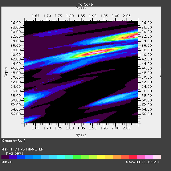
| Thickness Estimate: | 32 km |
| Thickness StdDev: | 8.7 km |
| Vp/Vs Estimate: | 2.10 |
| Vp/Vs StdDev: | 0.16 |
| Vs Estimate: | 2.908 km/s |
| Poisson's Ratio: | 0.35 |
| Peak Value: | 0.04 |
| Assumed Vp: | 6.1 km/s |
| Ps Weight: | 0.33333334 |
| PpPs Weight: | 0.33333334 |
| PsPs Weight: | 0.33333328 |
| Residual Complexity: | 0.702 |
| Nearby stations H: | +- |
| (2.0 deg) Vp/Vs: | +- |
3 with match > 90% ( 13.043478 %) and 5 with match > 80% ( 21.73913 %) out of 23.
Download stack as xyz text file.
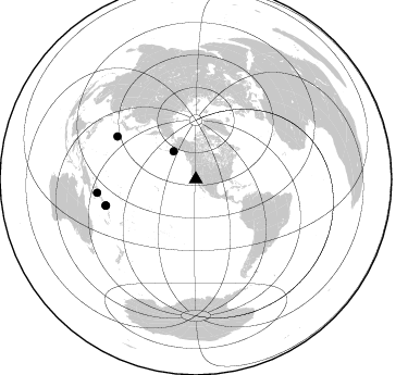
Azimuth Distribution of Events:
Prior Results for this Station
| Study | Thickness | Vp/Vs | Vp | Vs | Poissons Ratio | Extra |
| EARS | 32 km | 2.10 | 6.1 km/s | 2.908 km/s | 0.35 | |
| Crust2.0 | 31 km | 1.78 | 6.1 km/s | 3.426 km/s | 0.27 | M1,extended crust, 3 km seds. |
| Global Maxima | 32 km | 2.10 | 6.1 km/s | 2.908 km/s | 0.35 | amp=0.035165694 |
| Local Maxima 1 | 39 km | 1.91 | 6.1 km/s | 3.185 km/s | 0.31 | amp=0.026226291 |
| Local Maxima 2 | 30 km | 2.09 | 6.1 km/s | 2.922 km/s | 0.35 | amp=0.016581042 |
| Local Maxima 3 | 60 km | 1.61 | 6.1 km/s | 3.795 km/s | 0.18 | amp=0.013404679 |
| Local Maxima 4 | 59 km | 1.98 | 6.1 km/s | 3.077 km/s | 0.33 | amp=0.012759186 |
| Predicted Arrivals for vertical incidence (zero ray parameter) | |
| Ps | 5.71 SECOND |
| PpPs | 16.12 SECOND |
| PsPs/PpSs | 21.83 SECOND |
Events Processed for this Station
Download zip of receiver functions as SAC
Plot maxima for each earthquake.
Events Used in the Stack
(5 events)| Radial Match | Distance | Baz | FERegion | Time | Lat/Lon | Depth | Magnitude |
| 94.846924 | 32.9 deg | 321.571 deg | Alaska Peninsula | 2015/05/29 07:00:08 GMT | (56.7, -156.5) | 62 km | 6.8 MWP, 6.8 MI |
| 93.49391 | 82.2 deg | 298.539 deg | Bonin Islands, Japan Region | 2015/05/30 11:23:02 GMT | (27.8, 140.5) | 678 km | 7.8 MWP, 8.5 MI |
| 93.19644 | 91.5 deg | 262.166 deg | Solomon Islands | 2015/05/07 07:10:22 GMT | (-7.3, 154.5) | 22 km | 7.2 MWP, 7.2 MI |
| 89.208824 | 86.4 deg | 253.761 deg | Solomon Islands | 2015/05/22 21:45:18 GMT | (-11.1, 163.7) | 7.9 km | 6.8 MO |
| 86.487015 | 85.9 deg | 253.636 deg | Santa Cruz Islands Region | 2015/05/20 22:48:53 GMT | (-10.9, 164.2) | 12 km | 6.8 MWW, 6.7 MWB, 6.8 MWC, 6.9 MI |
Losers
(18 events)| Radial Match | Distance | Baz | FERegion | Time | Lat/Lon | Depth | Magnitude | Reason |
| 77.95054 | 91.3 deg | 265.151 deg | New Britain Region, P.N.G. | 2015/04/13 13:37:36 GMT | (-4.7, 153.0) | 59 km | 5.2 MW, 5.4 mb, 4.4 MS | |
| 72.82948 | 85.4 deg | 251.634 deg | Santa Cruz Islands | 2015/05/17 08:52:37 GMT | (-12.2, 165.8) | 18 km | 5.6 MW, 5.5 mb, 5.3 MS | |
| 72.06439 | 84.9 deg | 251.419 deg | Santa Cruz Islands | 2015/04/22 22:57:16 GMT | (-12.0, 166.4) | 74 km | 5.8 MB | |
| 69.56526 | 86.7 deg | 254.0 deg | Solomon Islands | 2015/05/23 00:39:30 GMT | (-11.1, 163.3) | 31 km | 5.3 mb, 5.3 mb | |
| 68.75149 | 72.6 deg | 235.222 deg | Tonga Islands | 2015/05/30 17:18:39 GMT | (-15.7, -173.3) | 51 km | 5.8 MB | |
| 64.54733 | 79.2 deg | 302.678 deg | Southeast Of Honshu, Japan | 2015/04/25 06:35:46 GMT | (32.9, 140.5) | 89 km | 5.2 mb, 5.2 mb | |
| 63.19542 | 64.7 deg | 309.389 deg | East Of Kuril Islands | 2015/05/26 17:56:06 GMT | (45.9, 152.4) | 41 km | 4.3 mb, 4.0 mb | |
| 63.098637 | 92.3 deg | 264.822 deg | New Britain Region, P.N.G. | 2015/05/05 08:16:58 GMT | (-5.6, 152.3) | 43 km | 5.8 MW | |
| 58.980785 | 90.5 deg | 262.555 deg | Solomon Islands | 2015/04/24 02:51:04 GMT | (-6.4, 155.1) | 56 km | 5.0 MW, 3.9 MS, 5.1 mb | |
| 57.22772 | 90.7 deg | 262.736 deg | Solomon Islands | 2015/04/21 19:10:17 GMT | (-6.4, 154.8) | 63 km | 5.4 MW, 5.4 mb | |
| 57.190723 | 81.3 deg | 230.417 deg | South Of Fiji Islands | 2015/04/17 21:52:52 GMT | (-25.3, -176.2) | 21 km | 5.2 MW, 5.0 mb, 4.6 MS | |
| 56.72993 | 30.4 deg | 126.659 deg | Near Coast Of Chiapas, Mexico | 2015/05/10 00:50:18 GMT | (14.9, -94.0) | 6.7 km | 5.6 MB | |
| 53.19522 | 57.2 deg | 132.129 deg | Near Coast Of Northern Peru | 2015/04/26 23:35:29 GMT | (-8.3, -79.8) | 22 km | 5.6 MWW, 5.6 MWB, 5.7 MWC | |
| 49.446087 | 93.0 deg | 264.958 deg | New Britain Region, P.N.G. | 2015/05/09 12:47:14 GMT | (-5.9, 151.7) | 41 km | 4.7 mb | |
| 47.193535 | 79.8 deg | 235.191 deg | Fiji Islands Region | 2015/04/28 16:39:38 GMT | (-20.9, -178.7) | 579 km | 6.2 MWB | |
| 43.13603 | 80.2 deg | 301.778 deg | Southeast Of Honshu, Japan | 2015/05/02 16:50:46 GMT | (31.6, 140.2) | 32 km | 5.7 MB | |
| 30.107952 | 61.7 deg | 315.465 deg | Northwest Of Kuril Islands | 2015/04/11 03:59:53 GMT | (52.0, 153.2) | 433 km | 4.7 mb, 4.7 mb | |
| 20.212101 | 91.5 deg | 262.299 deg | Solomon Islands | 2015/05/18 17:04:52 GMT | (-7.2, 154.4) | 10 km | 5.7 MWC, 5.6 MWB, 5.7 MWC |

