
Station TW TDCB - TE-CHI
Network: TW - Broadband Array in Taiwan for Seismology
Nearby stations (2 deg radius)

| Station | Name | (Lat, Lon) | Start / End | Elevation |
| TDCB | TE-CHI | (24.25, 121.16) | 1996-03-15 / 2499-01-01 | 1295 m |
| Crust2 Type: | K1,forearc, New Zealand, 2 km seds. |
| Thickness Estimate: | 28 km |
| Thickness StdDev: | 6.8 km |
| Vp/Vs Estimate: | 1.94 |
| Vp/Vs StdDev: | 0.13 |
| Vs Estimate: | 3.242 km/s |
| Poisson's Ratio: | 0.32 |
| Peak Value: | 0.01 |
| Assumed Vp: | 6.289 km/s |
| Ps Weight: | 0.33333334 |
| PpPs Weight: | 0.33333334 |
| PsPs Weight: | 0.33333328 |
| Residual Complexity: | 0.556 |
| Nearby stations H: | +- |
| (2.0 deg) Vp/Vs: | +- |
9 with match > 90% ( 15.254237 %) and 38 with match > 80% ( 64.40678 %) out of 59.
Download stack as xyz text file.
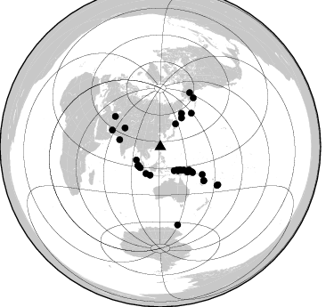
Azimuth Distribution of Events:
Prior Results for this Station
| Study | Thickness | Vp/Vs | Vp | Vs | Poissons Ratio | Extra |
| EARS | 28 km | 1.94 | 6.289 km/s | 3.242 km/s | 0.32 | |
| Crust2.0 | 35 km | 1.76 | 6.289 km/s | 3.569 km/s | 0.26 | K1,forearc, New Zealand, 2 km seds. |
| Global Maxima | 28 km | 1.94 | 6.289 km/s | 3.242 km/s | 0.32 | amp=0.006352367 |
| Local Maxima 1 | 50 km | 2.01 | 6.289 km/s | 3.125 km/s | 0.34 | amp=0.003113203 |
| Local Maxima 2 | 26 km | 1.87 | 6.289 km/s | 3.372 km/s | 0.30 | amp=0.0027888357 |
| Local Maxima 3 | 44 km | 1.63 | 6.289 km/s | 3.852 km/s | 0.20 | amp=0.0026966503 |
| Local Maxima 4 | 28 km | 1.98 | 6.289 km/s | 3.172 km/s | 0.33 | amp=0.0021918863 |
| Predicted Arrivals for vertical incidence (zero ray parameter) | |
| Ps | 4.11 SECOND |
| PpPs | 12.86 SECOND |
| PsPs/PpSs | 16.97 SECOND |
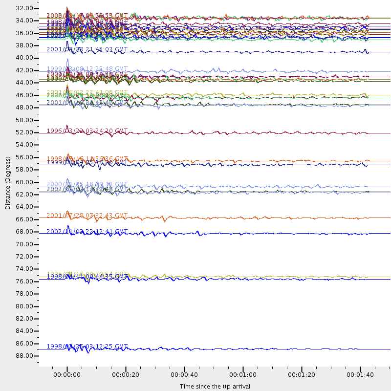
Events Processed for this Station
Download zip of receiver functions as SAC
Plot maxima for each earthquake.
Events Used in the Stack
(38 events)| Radial Match | Distance | Baz | FERegion | Time | Lat/Lon | Depth | Magnitude |
| 95.24251 | 61.7 deg | 127.96 deg | Vanuatu Islands | 2002/01/02 17:22:48 GMT | (-17.6, 167.9) | 21 km | 6.3 MB, 7.5 MS, 7.3 MW, 7.1 MW |
| 93.33025 | 41.2 deg | 128.729 deg | New Ireland Region, P.N.G. | 2000/11/16 04:54:56 GMT | (-4.0, 152.2) | 33 km | 6.0 MB, 8.2 MS, 8.0 MW, 8.0 ME |
| 92.76055 | 56.2 deg | 123.369 deg | Santa Cruz Islands | 1998/07/16 11:56:36 GMT | (-11.0, 166.2) | 110 km | 6.4 MB, 6.7 MS, 7.1 UNKNOWN, 6.9 ME |
| 92.69672 | 46.4 deg | 279.881 deg | Southern India | 2001/01/26 03:16:40 GMT | (23.4, 70.2) | 16 km | 6.9 MB, 8.0 MS, 7.7 MW, 7.7 ME |
| 92.22483 | 40.3 deg | 36.376 deg | Off East Coast Of Kamchatka | 1999/03/08 12:25:48 GMT | (52.1, 159.5) | 57 km | 5.7 MB, 6.9 MW, 6.8 MW |
| 92.03777 | 42.0 deg | 130.74 deg | New Britain Region, P.N.G. | 2000/11/17 21:01:56 GMT | (-5.5, 151.8) | 33 km | 6.2 MB, 8.0 MS, 7.6 MW, 6.9 ME |
| 90.425415 | 44.9 deg | 298.044 deg | Hindu Kush Region, Afghanistan | 2002/03/03 12:08:19 GMT | (36.5, 70.5) | 226 km | 6.6 MB, 7.4 MW, 7.3 MW |
| 90.12888 | 41.2 deg | 132.898 deg | New Britain Region, P.N.G. | 2001/10/31 09:10:20 GMT | (-5.9, 150.2) | 33 km | 5.9 MB, 6.9 MS, 6.9 MW, 6.9 MW |
| 90.10178 | 36.8 deg | 134.875 deg | Bismarck Sea | 2001/08/23 21:45:03 GMT | (-3.4, 146.3) | 10 km | 5.8 MB, 6.2 MS, 6.2 MW, 6.0 MW |
| 89.22065 | 32.5 deg | 223.895 deg | Southern Sumatra, Indonesia | 1998/04/01 17:56:23 GMT | (-0.5, 99.3) | 56 km | 6.2 MB, 6.9 MS, 7.0 UNKNOWN, 6.6 ME |
| 88.89274 | 30.8 deg | 149.797 deg | Irian Jaya, Indonesia | 2000/08/12 10:26:15 GMT | (-3.1, 136.1) | 33 km | 5.6 MB, 5.7 MS, 6.0 MW, 5.9 MW |
| 88.69544 | 51.3 deg | 42.86 deg | Rat Islands, Aleutian Islands | 1996/03/22 03:24:20 GMT | (51.2, 178.7) | 20 km | 5.7 MB, 6.6 MS, 6.8 UNKNOWN, 6.6 ML |
| 88.28311 | 60.8 deg | 303.887 deg | Eastern Caucasus | 2000/11/25 18:09:11 GMT | (40.2, 49.9) | 50 km | 5.8 MB, 6.3 MW |
| 88.22643 | 76.8 deg | 124.149 deg | South Of Fiji Islands | 1996/04/16 00:30:54 GMT | (-24.1, -177.0) | 111 km | 6.4 MB, 6.8 MS, 7.1 UNKNOWN, 7.1 MW |
| 88.21834 | 45.0 deg | 128.494 deg | Solomon Islands | 1996/04/29 14:40:41 GMT | (-6.5, 155.0) | 44 km | 6.3 MB, 7.5 MS, 7.2 UNKNOWN, 6.8 ME |
| 87.88858 | 69.2 deg | 28.65 deg | Central Alaska | 2002/11/03 22:12:41 GMT | (63.5, -147.4) | 4.9 km | 7.0 MB, 8.5 MS, 7.9 MW |
| 87.71055 | 46.2 deg | 128.55 deg | Solomon Islands | 2001/04/19 21:43:42 GMT | (-7.4, 155.9) | 17 km | 6.0 MB, 6.6 MS, 6.7 MW, 6.2 ME |
| 87.354965 | 33.8 deg | 140.415 deg | Near N Coast Of New Guinea, P.N.G. | 1998/07/17 08:49:13 GMT | (-3.0, 141.9) | 10 km | 5.8 MB, 7.1 MS, 7.1 UNKNOWN, 6.4 ME |
| 87.34248 | 33.3 deg | 143.597 deg | Irian Jaya, Indonesia | 2002/10/17 17:52:44 GMT | (-3.6, 140.2) | 33 km | 5.6 MB, 6.2 MS, 6.3 MW, 6.3 MW |
| 87.04009 | 61.8 deg | 127.91 deg | Vanuatu Islands | 2002/01/03 10:17:36 GMT | (-17.7, 168.0) | 10 km | 5.8 MB, 6.4 MS, 6.7 MW, 6.4 MW |
| 87.001854 | 34.2 deg | 208.278 deg | Sunda Strait, Indonesia | 2000/10/25 09:32:23 GMT | (-6.5, 105.6) | 38 km | 6.3 MB, 6.6 MS, 6.8 MW, 6.7 ME |
| 86.74763 | 44.5 deg | 32.653 deg | Near East Coast Of Kamchatka | 2001/08/02 23:41:06 GMT | (56.3, 163.8) | 14 km | 5.9 MB, 6.2 MS, 6.3 MW, 6.2 ME |
| 86.59637 | 32.2 deg | 229.849 deg | Northern Sumatra, Indonesia | 2005/07/05 01:52:02 GMT | (1.8, 97.1) | 21 km | 6.2 MB, 6.8 MS, 6.7 MW, 6.6 MW |
| 85.80485 | 33.7 deg | 199.894 deg | Java, Indonesia | 2001/05/25 05:06:10 GMT | (-7.9, 110.2) | 143 km | 5.8 MB, 6.3 MW, 6.3 MW |
| 85.38062 | 31.9 deg | 144.781 deg | Irian Jaya, Indonesia | 1998/07/29 18:00:29 GMT | (-2.7, 138.9) | 33 km | 5.9 MB, 6.7 MS, 6.6 UNKNOWN, 6.2 ME |
| 85.25831 | 34.3 deg | 139.95 deg | Near N Coast Of New Guinea, P.N.G. | 2002/01/10 11:14:56 GMT | (-3.2, 142.4) | 11 km | 6.0 MB, 6.6 MS, 6.7 MW, 6.6 MW |
| 85.220406 | 66.3 deg | 34.143 deg | Southern Alaska | 2001/07/28 07:32:43 GMT | (59.0, -155.1) | 131 km | 5.7 MB, 5.7 MS, 6.6 MW, 6.2 ME |
| 84.97273 | 34.6 deg | 139.316 deg | Near N Coast Of New Guinea, P.N.G. | 2001/10/07 02:21:09 GMT | (-3.3, 142.9) | 10 km | 5.7 MB, 6.1 MS, 6.2 MW, 6.2 MW |
| 84.61221 | 41.6 deg | 131.663 deg | New Britain Region, P.N.G. | 2002/01/13 14:10:56 GMT | (-5.7, 151.1) | 44 km | 5.9 MB, 6.4 MS, 6.3 MW, 6.3 MW |
| 84.08255 | 32.9 deg | 230.01 deg | Off W Coast Of Northern Sumatra | 2000/09/01 11:56:51 GMT | (1.4, 96.6) | 33 km | 5.6 MB, 6.0 MS, 6.2 MW, 6.0 MW |
| 84.021866 | 32.8 deg | 227.121 deg | Northern Sumatra, Indonesia | 2001/05/18 02:05:33 GMT | (0.4, 97.8) | 33 km | 5.4 MB, 5.8 MS, 5.9 MW, 5.9 MW |
| 83.48879 | 30.8 deg | 33.876 deg | Northwest Of Kuril Islands | 2002/11/17 04:53:53 GMT | (47.8, 146.2) | 459 km | 7.3 MW, 7.3 MW |
| 82.907906 | 56.9 deg | 289.022 deg | Southern Iran | 1999/03/04 05:38:26 GMT | (28.3, 57.2) | 33 km | 6.2 MB, 6.5 MS, 6.6 MW, 6.4 MW |
| 82.57885 | 89.7 deg | 167.422 deg | Balleny Islands Region | 1998/03/25 03:12:25 GMT | (-62.9, 149.5) | 10 km | 6.6 MB, 8.0 MS, 8.3 UNKNOWN, 8.1 MW |
| 82.5594 | 30.7 deg | 241.242 deg | Nicobar Islands, India Region | 1998/08/10 09:52:14 GMT | (7.3, 94.3) | 33 km | 5.9 MB, 5.8 MS, 6.0 UNKNOWN |
| 81.465775 | 41.7 deg | 130.45 deg | New Britain Region, P.N.G. | 1998/05/13 23:02:05 GMT | (-5.1, 151.7) | 61 km | 6.0 MB, 6.6 UNKNOWN, 5.9 ME |
| 81.03834 | 33.2 deg | 142.667 deg | Irian Jaya, Indonesia | 1998/03/26 23:36:11 GMT | (-3.2, 140.6) | 10 km | 5.6 MB, 5.6 MS, 5.7 UNKNOWN, 5.5 MW |
| 80.09317 | 77.3 deg | 123.302 deg | South Of Fiji Islands | 1998/04/11 00:44:35 GMT | (-23.6, -176.1) | 33 km | 5.7 MB, 6.1 MS, 6.2 UNKNOWN, 6.1 MW |
Losers
(21 events)| Radial Match | Distance | Baz | FERegion | Time | Lat/Lon | Depth | Magnitude | Reason |
| 85.835526 | 71.6 deg | 119.692 deg | Fiji Islands Region | 1998/03/29 19:48:16 GMT | (-17.6, -179.1) | 537 km | 6.5 MB, 7.2 UNKNOWN, 7.1 MW | |
| 78.50937 | 73.9 deg | 123.945 deg | South Of Fiji Islands | 1998/05/16 02:22:03 GMT | (-22.2, -179.5) | 586 km | 6.1 MB, 6.8 UNKNOWN | |
| 77.7133 | 45.0 deg | 128.784 deg | Solomon Islands | 1996/05/01 09:21:24 GMT | (-6.7, 154.8) | 33 km | 5.5 MB, 5.9 MS, 6.0 UNKNOWN, 5.9 MW | |
| 77.42516 | 44.7 deg | 297.888 deg | Hindu Kush Region, Afghanistan | 1999/06/21 17:37:27 GMT | (36.4, 70.7) | 230 km | 5.6 MW, 5.4 MB, 5.5 MW | |
| 75.009 | 53.6 deg | 42.79 deg | Andreanof Islands, Aleutian Is. | 1999/03/20 10:47:45 GMT | (51.6, -177.7) | 33 km | 6.3 MB, 6.8 MS, 6.9 MW, 6.8 ME | |
| 74.783554 | 45.2 deg | 298.886 deg | Afghanistan-Tajikistan Bord Reg. | 1998/05/30 06:22:28 GMT | (37.1, 70.1) | 33 km | 5.9 MB, 6.9 MS, 6.6 UNKNOWN, 6.5 MW | |
| 74.66337 | 59.4 deg | 125.851 deg | Vanuatu Islands | 1996/03/17 14:48:56 GMT | (-14.7, 167.3) | 164 km | 5.8 MB, 6.0 MS, 6.7 UNKNOWN, 6.1 MS | |
| 73.86355 | 83.9 deg | 157.67 deg | Macquarie Island Region | 1998/06/16 09:35:11 GMT | (-53.0, 159.8) | 10 km | 5.7 MS, 4.9 MB, 6.2 UNKNOWN, 6.1 MW | |
| 73.755196 | 31.2 deg | 195.636 deg | Java, Indonesia | 1998/04/27 23:51:35 GMT | (-6.1, 113.1) | 591 km | 5.5 MB | |
| 72.665985 | 59.1 deg | 42.382 deg | Fox Islands, Aleutian Islands | 1996/03/30 13:05:17 GMT | (52.2, -168.7) | 33 km | 5.9 MB, 6.2 MS, 6.3 UNKNOWN, 6.1 ML | |
| 70.719536 | 43.5 deg | 126.618 deg | Solomon Islands | 1996/05/02 13:34:28 GMT | (-4.5, 154.8) | 500 km | 5.6 MB, 6.6 UNKNOWN, 6.5 MW | |
| 69.12733 | 58.4 deg | 125.188 deg | Vanuatu Islands | 1998/07/25 02:39:23 GMT | (-13.6, 166.9) | 44 km | 5.9 MB, 6.0 MS, 6.3 UNKNOWN, 6.2 MW | |
| 68.68434 | 45.2 deg | 128.418 deg | Solomon Islands | 1998/09/05 05:16:17 GMT | (-6.6, 155.2) | 37 km | 5.5 MB, 5.7 MS, 5.8 UNKNOWN, 5.8 MW | |
| 63.64569 | 31.9 deg | 165.252 deg | Banda Sea | 1998/11/09 05:38:44 GMT | (-6.9, 128.9) | 33 km | 6.4 MB, 7.0 MS, 7.3 UNKNOWN, 7.0 MW | |
| 63.54158 | 80.5 deg | 133.28 deg | South Of Kermadec Islands | 1998/04/10 16:43:41 GMT | (-33.5, -179.5) | 46 km | 5.9 MB, 5.9 MS, 6.0 UNKNOWN, 6.0 MW | |
| 61.102203 | 63.4 deg | 241.202 deg | Mid-Indian Ridge | 1998/04/09 23:26:52 GMT | (-12.2, 67.8) | 10 km | 5.5 MB, 5.4 MS, 5.9 UNKNOWN, 5.9 MW | |
| 59.430145 | 93.4 deg | 161.399 deg | Balleny Islands Region | 1996/03/23 10:46:45 GMT | (-62.7, 164.9) | 10 km | 5.5 MS, 5.0 MB | |
| 56.543697 | 90.1 deg | 168.386 deg | South Of Australia | 1998/03/25 12:17:22 GMT | (-63.6, 147.9) | 10 km | 5.8 MB, 6.1 MS, 6.5 UNKNOWN | |
| 55.546024 | 52.6 deg | 126.768 deg | Solomon Islands | 1996/04/11 11:24:26 GMT | (-10.8, 161.5) | 43 km | 5.9 MB, 5.8 MS, 6.0 UNKNOWN, 5.8 MW | |
| 52.642807 | 75.8 deg | 121.765 deg | Fiji Islands Region | 1998/11/15 02:44:12 GMT | (-21.6, -176.5) | 149 km | 5.9 MB, 6.3 UNKNOWN, 6.2 MW | |
| 52.28884 | 90.0 deg | 168.395 deg | South Of Australia | 1998/03/25 13:14:59 GMT | (-63.6, 147.9) | 10 km | 5.8 MS, 5.4 MB |
