
Station TX MB08 - UTPB
Network: TX - Texas Seismological Network
Nearby stations (2 deg radius)
| Station | Name | (Lat, Lon) | Start / End | Elevation |
| MB08 | UTPB | (31.88, -102.33) | 2023-08-08 / 2499-01-01 | 863 m |
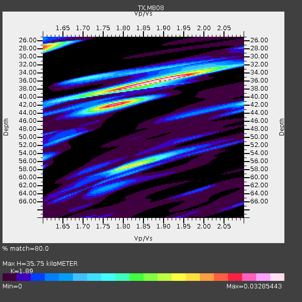
| Crust2 Type: | Q1,orogen/39km no ice, Appalachians, North Andes |
| Thickness Estimate: | 36 km |
| Thickness StdDev: | 6.0 km |
| Vp/Vs Estimate: | 1.89 |
| Vp/Vs StdDev: | 0.14 |
| Vs Estimate: | 3.238 km/s |
| Poisson's Ratio: | 0.31 |
| Peak Value: | 0.03 |
| Assumed Vp: | 6.121 km/s |
| Ps Weight: | 0.33333334 |
| PpPs Weight: | 0.33333334 |
| PsPs Weight: | 0.33333328 |
| Residual Complexity: | 0.659 |
| Nearby stations H: | +- |
| (2.0 deg) Vp/Vs: | +- |
1 with match > 90% ( 2.9411764 %) and 3 with match > 80% ( 8.823529 %) out of 34.
Download stack as xyz text file.
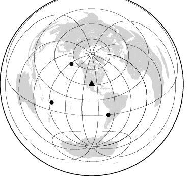
Azimuth Distribution of Events:
Prior Results for this Station
| Study | Thickness | Vp/Vs | Vp | Vs | Poissons Ratio | Extra |
| EARS | 36 km | 1.89 | 6.121 km/s | 3.238 km/s | 0.31 | |
| Crust2.0 | 39 km | 1.76 | 6.121 km/s | 3.485 km/s | 0.26 | Q1,orogen/39km no ice, Appalachians, North Andes |
| Global Maxima | 36 km | 1.89 | 6.121 km/s | 3.238 km/s | 0.31 | amp=0.03285443 |
| Local Maxima 1 | 28 km | 1.60 | 6.121 km/s | 3.825 km/s | 0.18 | amp=0.026605677 |
| Local Maxima 2 | 57 km | 1.81 | 6.121 km/s | 3.381 km/s | 0.28 | amp=0.022720696 |
| Local Maxima 3 | 42 km | 1.78 | 6.121 km/s | 3.443 km/s | 0.27 | amp=0.021730024 |
| Local Maxima 4 | 39 km | 1.75 | 6.121 km/s | 3.497 km/s | 0.26 | amp=0.014677313 |
| Predicted Arrivals for vertical incidence (zero ray parameter) | |
| Ps | 5.20 SECOND |
| PpPs | 16.88 SECOND |
| PsPs/PpSs | 22.08 SECOND |
Events Processed for this Station
Download zip of receiver functions as SAC
Plot maxima for each earthquake.
Events Used in the Stack
(3 events)| Radial Match | Distance | Baz | FERegion | Time | Lat/Lon | Depth | Magnitude |
| 92.16019 | 68.4 deg | 151.551 deg | Near Coast Of Central Chile | 2023/09/06 23:48:05 UTC | (-30.3, -71.5) | 41 km | 6.2 mww |
| 86.19847 | 86.2 deg | 245.411 deg | Tonga Islands | 2023/12/11 06:33:31 UTC | (-18.7, -175.5) | 238 km | 6.1 Mww |
| 85.3126 | 56.3 deg | 314.851 deg | Andreanof Islands, Aleutian Is. | 2023/10/16 11:35:31 UTC | (52.4, -176.9) | 187 km | 6.4 Mww |
Losers
(31 events)| Radial Match | Distance | Baz | FERegion | Time | Lat/Lon | Depth | Magnitude | Reason |
| 88.669136 | 94.8 deg | 309.673 deg | Southeast Of Honshu, Japan | 2023/10/05 02:53:13 UTC | (30.0, 139.8) | 10 km | 5.7 Mww | |
| 88.36108 | 38.5 deg | 129.681 deg | Colombia | 2023/08/17 17:17:18 UTC | (4.2, -73.6) | 7.9 km | 5.7 Mww | |
| 79.91279 | 50.7 deg | 75.757 deg | Northern Mid-Atlantic Ridge | 2024/03/14 21:10:25 UTC | (29.8, -42.7) | 10 km | 6.0 mww | |
| 74.620224 | 97.5 deg | 257.106 deg | Vanuatu Islands | 2023/11/22 04:47:31 UTC | (-15.0, 168.0) | 13 km | 6.7 mww | |
| 70.33776 | 38.4 deg | 129.467 deg | Colombia | 2023/08/17 17:04:48 UTC | (4.4, -73.6) | 10 km | 6.2 mww | |
| 67.81064 | 85.7 deg | 316.561 deg | Hokkaido, Japan Region | 2023/08/11 00:14:32 UTC | (41.1, 142.8) | 30 km | 5.9 mww | |
| 65.96513 | 79.4 deg | 316.576 deg | Kuril Islands | 2023/11/08 08:16:29 UTC | (45.0, 149.8) | 68 km | 5.6 mb | |
| 65.87509 | 94.6 deg | 309.647 deg | Southeast Of Honshu, Japan | 2023/10/05 06:22:12 UTC | (30.1, 140.0) | 10 km | 5.6 Mww | |
| 64.97643 | 68.1 deg | 176.283 deg | Southeast Of Easter Island | 2023/09/14 22:51:26 UTC | (-36.5, -98.0) | 10 km | 5.6 mww | |
| 63.575047 | 96.9 deg | 237.451 deg | Kermadec Islands Region | 2023/10/14 06:34:11 UTC | (-31.3, 179.7) | 415 km | 5.7 mww | |
| 63.31899 | 94.1 deg | 237.278 deg | Kermadec Islands, New Zealand | 2023/10/23 10:10:15 UTC | (-29.9, -177.5) | 23 km | 6.0 Mww | |
| 60.96457 | 96.1 deg | 236.935 deg | Kermadec Islands Region | 2024/03/19 02:25:31 UTC | (-31.3, -179.1) | 9.2 km | 5.5 Mww | |
| 60.544125 | 60.0 deg | 143.252 deg | Northern Chile | 2023/12/02 07:55:40 UTC | (-19.2, -69.1) | 106 km | 5.8 Mww | |
| 59.9333 | 72.6 deg | 319.204 deg | Kuril Islands | 2023/09/01 20:49:54 UTC | (50.7, 156.3) | 141 km | 6.1 Mww | |
| 59.18749 | 78.1 deg | 316.876 deg | Kuril Islands | 2023/11/10 10:10:04 UTC | (45.9, 151.0) | 107 km | 5.8 mww | |
| 55.99594 | 65.7 deg | 322.084 deg | Komandorskiye Ostrova Region | 2023/10/26 16:05:11 UTC | (56.1, 164.7) | 2.4 km | 5.9 Mww | |
| 55.864227 | 93.3 deg | 41.662 deg | Southern Greece | 2024/03/29 07:12:47 UTC | (37.3, 21.3) | 25 km | 5.8 Mww | |
| 55.396843 | 88.3 deg | 92.983 deg | North Of Ascension Island | 2024/03/26 13:14:08 UTC | (-1.6, -15.4) | 10 km | 5.4 mww | |
| 55.2203 | 89.1 deg | 314.173 deg | Near East Coast Of Honshu, Japan | 2024/03/16 21:17:04 UTC | (37.1, 141.5) | 45 km | 5.3 Mww | |
| 53.112686 | 88.0 deg | 244.34 deg | Fiji Islands Region | 2023/10/28 04:33:30 UTC | (-20.6, -176.4) | 215 km | 5.5 Mww | |
| 52.24819 | 87.0 deg | 316.357 deg | Near East Coast Of Honshu, Japan | 2024/04/01 19:24:36 UTC | (40.1, 141.7) | 73 km | 5.9 mww | |
| 49.892883 | 97.0 deg | 235.828 deg | South Of Kermadec Islands | 2023/09/08 09:09:58 UTC | (-32.7, -179.3) | 90 km | 6.6 mww | |
| 46.389526 | 43.4 deg | 106.294 deg | Windward Islands | 2023/11/28 15:26:12 UTC | (12.6, -59.8) | 39 km | 5.1 Mww | |
| 45.936928 | 52.9 deg | 314.529 deg | Fox Islands, Aleutian Islands | 2023/10/12 02:41:11 UTC | (52.6, -171.2) | 125 km | 5.5 ml | |
| 45.68002 | 77.9 deg | 96.694 deg | Central Mid-Atlantic Ridge | 2023/09/11 09:20:56 UTC | (0.7, -26.1) | 10 km | 5.9 Mww | |
| 45.008194 | 66.5 deg | 181.795 deg | West Chile Rise | 2023/12/07 01:17:44 UTC | (-34.9, -104.3) | 10 km | 5.8 Mww | |
| 44.766556 | 80.4 deg | 316.459 deg | Kuril Islands | 2023/09/28 17:40:04 UTC | (44.3, 148.6) | 15 km | 5.8 mww | |
| 43.91349 | 86.4 deg | 315.141 deg | Off East Coast Of Honshu, Japan | 2023/08/24 22:48:26 UTC | (39.6, 143.3) | 35 km | 5.8 Mww | |
| 43.189007 | 94.6 deg | 309.604 deg | Southeast Of Honshu, Japan | 2023/10/06 01:31:17 UTC | (30.0, 140.0) | 10 km | 6.1 mww | |
| 41.617706 | 92.8 deg | 309.274 deg | Southeast Of Honshu, Japan | 2023/09/21 21:22:12 UTC | (31.0, 141.8) | 13 km | 5.7 Mww | |
| 34.049213 | 88.4 deg | 314.395 deg | Near East Coast Of Honshu, Japan | 2024/04/04 03:16:31 UTC | (37.7, 141.9) | 40 km | 6.1 Mww |

