
Station TX MB12 - Knott, TX
Network: TX - Texas Seismological Network
Nearby stations (2 deg radius)
| Station | Name | (Lat, Lon) | Start / End | Elevation |
| MB12 | Knott, TX | (32.37, -101.60) | 2022-07-13 / 2499-01-01 | 776 m |
| Crust2 Type: | D8,thick Platform 3 km seds. |
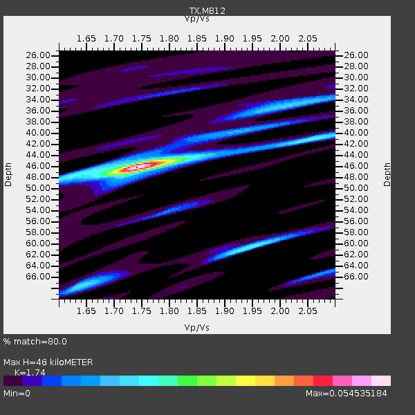
| Thickness Estimate: | 46 km |
| Thickness StdDev: | 8.6 km |
| Vp/Vs Estimate: | 1.74 |
| Vp/Vs StdDev: | 0.15 |
| Vs Estimate: | 3.693 km/s |
| Poisson's Ratio: | 0.25 |
| Peak Value: | 0.03 |
| Assumed Vp: | 6.426 km/s |
| Ps Weight: | 0.33333334 |
| PpPs Weight: | 0.33333334 |
| PsPs Weight: | 0.33333328 |
| Residual Complexity: | 0.490 |
| Nearby stations H: | +- |
| (2.0 deg) Vp/Vs: | +- |
0 with match > 90% ( 0.0 %) and 4 with match > 80% ( 8.163265 %) out of 49.
Download stack as xyz text file.
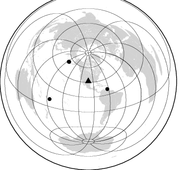
Azimuth Distribution of Events:
Prior Results for this Station
| Study | Thickness | Vp/Vs | Vp | Vs | Poissons Ratio | Extra |
| EARS | 46 km | 1.74 | 6.426 km/s | 3.693 km/s | 0.25 | |
| Crust2.0 | 46 km | 1.78 | 6.426 km/s | 3.613 km/s | 0.27 | D8,thick Platform 3 km seds. |
| Global Maxima | 46 km | 1.74 | 6.426 km/s | 3.693 km/s | 0.25 | amp=0.032499205 |
| Local Maxima 1 | 41 km | 2.06 | 6.426 km/s | 3.123 km/s | 0.35 | amp=0.01742634 |
| Local Maxima 2 | 65 km | 2.08 | 6.426 km/s | 3.089 km/s | 0.35 | amp=0.01549998 |
| Local Maxima 3 | 60 km | 1.96 | 6.426 km/s | 3.283 km/s | 0.32 | amp=0.011066552 |
| Local Maxima 4 | 35 km | 2.00 | 6.426 km/s | 3.209 km/s | 0.33 | amp=0.009881329 |
| Predicted Arrivals for vertical incidence (zero ray parameter) | |
| Ps | 5.30 SECOND |
| PpPs | 19.61 SECOND |
| PsPs/PpSs | 24.91 SECOND |
Events Processed for this Station
Download zip of receiver functions as SAC
Plot maxima for each earthquake.
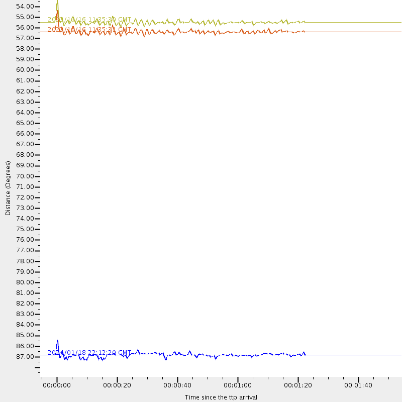
Events Used in the Stack
(4 events)| Radial Match | Distance | Baz | FERegion | Time | Lat/Lon | Depth | Magnitude |
| 89.5642 | 55.5 deg | 315.326 deg | Andreanof Islands, Aleutian Is. | 2023/10/16 11:35:30 UTC | (53.1, -175.5) | 253 km | 6.7 Mi |
| 88.52117 | 56.4 deg | 314.719 deg | Andreanof Islands, Aleutian Is. | 2023/10/16 11:35:31 UTC | (52.4, -176.9) | 187 km | 6.4 Mww |
| 81.89368 | 41.8 deg | 112.037 deg | Near Coast Of Venezuela | 2024/06/23 03:58:00 UTC | (10.8, -62.6) | 87 km | 6.0 mww |
| 80.232994 | 86.8 deg | 245.395 deg | Tonga Islands | 2024/01/18 22:12:20 UTC | (-18.9, -175.1) | 218 km | 6.4 Mww |
Losers
(45 events)| Radial Match | Distance | Baz | FERegion | Time | Lat/Lon | Depth | Magnitude | Reason |
| 76.40037 | 49.6 deg | 139.117 deg | Western Brazil | 2024/01/28 09:38:56 UTC | (-8.2, -71.4) | 609 km | 6.5 Mww | |
| 75.937 | 96.5 deg | 236.838 deg | Kermadec Islands Region | 2024/05/12 18:43:20 UTC | (-31.5, -178.5) | 23 km | 5.8 Mww | |
| 74.10683 | 97.8 deg | 261.452 deg | Santa Cruz Islands | 2024/06/17 14:09:44 UTC | (-11.5, 166.2) | 49 km | 5.6 mww | |
| 69.84902 | 50.0 deg | 76.407 deg | Northern Mid-Atlantic Ridge | 2024/03/14 21:10:25 UTC | (29.8, -42.7) | 10 km | 6.0 mww | |
| 68.91486 | 48.8 deg | 138.606 deg | Western Brazil | 2024/01/20 21:31:07 UTC | (-7.3, -71.5) | 629 km | 6.5 Mww | |
| 68.10119 | 37.1 deg | 187.144 deg | Central East Pacific Rise | 2023/09/20 15:03:36 UTC | (-4.7, -105.9) | 10 km | 5.7 mww | |
| 66.251236 | 77.6 deg | 321.963 deg | Sea Of Okhotsk | 2024/06/06 11:07:53 UTC | (50.1, 147.6) | 622 km | 5.9 mww | |
| 65.97384 | 46.5 deg | 317.075 deg | Alaska Peninsula | 2023/09/21 01:13:58 UTC | (54.9, -160.3) | 24 km | 5.5 ml | |
| 64.68484 | 96.6 deg | 249.397 deg | Vanuatu Islands Region | 2023/11/27 03:31:16 UTC | (-21.0, 173.9) | 10 km | 5.5 Mww | |
| 64.54351 | 53.0 deg | 314.327 deg | Fox Islands, Aleutian Islands | 2023/10/12 02:41:11 UTC | (52.6, -171.2) | 125 km | 5.5 ml | |
| 64.29319 | 88.2 deg | 315.505 deg | Near East Coast Of Honshu, Japan | 2023/09/18 19:33:05 UTC | (38.5, 141.6) | 67 km | 5.5 mww | |
| 63.834095 | 89.8 deg | 191.695 deg | Southern East Pacific Rise | 2023/12/14 09:29:44 UTC | (-56.0, -122.8) | 10 km | 5.5 Mww | |
| 61.992134 | 95.3 deg | 200.303 deg | Pacific-Antarctic Ridge | 2023/12/05 17:16:38 UTC | (-57.3, -141.1) | 10 km | 5.5 Mww | |
| 61.54216 | 98.0 deg | 31.548 deg | Turkey | 2024/04/18 15:11:25 UTC | (40.0, 36.0) | 10 km | 5.6 Mww | |
| 60.871117 | 97.1 deg | 299.221 deg | Mariana Islands | 2023/12/16 09:50:53 UTC | (20.3, 145.7) | 10 km | 5.7 mww | |
| 60.15688 | 94.8 deg | 310.052 deg | Southeast Of Honshu, Japan | 2023/10/06 01:31:17 UTC | (30.0, 140.0) | 10 km | 6.1 mww | |
| 59.64383 | 97.3 deg | 316.837 deg | Shikoku, Japan | 2024/04/17 14:14:45 UTC | (33.2, 132.4) | 26 km | 6.3 mww | |
| 58.536427 | 64.9 deg | 97.289 deg | Central Mid-Atlantic Ridge | 2023/10/14 08:29:34 UTC | (7.5, -36.7) | 10 km | 5.5 Mww | |
| 57.417736 | 80.1 deg | 97.795 deg | Central Mid-Atlantic Ridge | 2023/11/06 12:04:21 UTC | (-1.2, -24.1) | 10 km | 5.5 Mww | |
| 57.330025 | 88.0 deg | 245.048 deg | Tonga Islands | 2024/03/31 03:01:44 UTC | (-19.9, -176.0) | 10 km | 5.5 Mww | |
| 57.25402 | 84.4 deg | 246.595 deg | Tonga Islands | 2024/06/18 06:40:36 UTC | (-16.5, -173.8) | 35 km | 5.9 mww | |
| 56.588234 | 94.9 deg | 310.021 deg | Southeast Of Honshu, Japan | 2023/10/05 01:59:58 UTC | (30.0, 139.9) | 10 km | 6.1 mww | |
| 56.587082 | 93.0 deg | 309.697 deg | Southeast Of Honshu, Japan | 2023/09/21 21:22:12 UTC | (31.0, 141.8) | 13 km | 5.7 Mww | |
| 55.665966 | 85.1 deg | 244.015 deg | Tonga Islands Region | 2024/06/17 14:05:11 UTC | (-19.0, -172.8) | 10 km | 5.6 Mww | |
| 54.633476 | 85.7 deg | 316.538 deg | Off East Coast Of Honshu, Japan | 2024/04/06 00:12:17 UTC | (40.9, 143.2) | 19 km | 5.4 Mww | |
| 52.802948 | 67.3 deg | 151.562 deg | Near Coast Of Central Chile | 2024/02/14 01:31:41 UTC | (-28.9, -71.5) | 22 km | 6.0 mww | |
| 52.42692 | 37.1 deg | 186.499 deg | Central East Pacific Rise | 2023/09/09 03:09:49 UTC | (-4.7, -105.5) | 10 km | 5.8 Mww | |
| 51.927998 | 68.6 deg | 176.922 deg | Southeast Of Easter Island | 2023/09/14 22:51:26 UTC | (-36.5, -98.0) | 10 km | 5.6 mww | |
| 51.289104 | 74.8 deg | 98.667 deg | Central Mid-Atlantic Ridge | 2023/11/21 05:10:26 UTC | (1.0, -29.0) | 10 km | 5.5 Mww | |
| 50.515522 | 94.9 deg | 309.97 deg | Southeast Of Honshu, Japan | 2023/10/03 11:38:04 UTC | (29.9, 140.0) | 12 km | 6.1 Mww | |
| 48.523903 | 94.6 deg | 310.082 deg | Southeast Of Honshu, Japan | 2023/10/06 13:15:27 UTC | (30.2, 140.1) | 10 km | 5.0 Mww | |
| 48.39313 | 39.0 deg | 338.874 deg | Northern Yukon Territory, Canada | 2024/06/02 14:02:42 UTC | (65.8, -135.0) | 16 km | 4.9 Mww | |
| 48.3664 | 88.8 deg | 247.976 deg | Fiji Islands Region | 2024/03/09 12:01:07 UTC | (-18.0, -178.4) | 577 km | 5.5 mb | |
| 48.365 | 88.4 deg | 92.397 deg | North Of Ascension Island | 2024/05/04 05:52:35 UTC | (-1.2, -14.3) | 10 km | 5.4 Mww | |
| 46.26462 | 74.0 deg | 156.408 deg | Near Coast Of Central Chile | 2024/04/03 13:51:56 UTC | (-37.0, -72.9) | 36 km | 5.2 Mww | |
| 45.965157 | 89.4 deg | 242.582 deg | Tonga Islands Region | 2023/12/24 02:22:17 UTC | (-22.7, -175.7) | 49 km | 5.3 Mww | |
| 45.476192 | 67.0 deg | 182.436 deg | West Chile Rise | 2023/12/07 01:17:44 UTC | (-34.9, -104.3) | 10 km | 5.8 Mww | |
| 45.31504 | 86.1 deg | 243.571 deg | Tonga Islands | 2023/12/12 12:54:05 UTC | (-20.0, -173.4) | 10 km | 5.6 mww | |
| 44.586857 | 90.3 deg | 199.187 deg | Pacific-Antarctic Ridge | 2023/09/27 17:37:36 UTC | (-53.5, -135.0) | 10 km | 5.6 Mww | |
| 43.76963 | 68.8 deg | 174.552 deg | West Chile Rise | 2024/06/04 18:32:56 UTC | (-36.6, -95.3) | 10 km | 5.5 Mwb | |
| 40.461395 | 52.8 deg | 313.69 deg | Fox Islands, Aleutian Islands | 2024/05/19 09:35:24 UTC | (52.2, -170.9) | 28 km | 6.0 mww | |
| 40.395733 | 92.9 deg | 309.633 deg | Southeast Of Honshu, Japan | 2023/09/19 06:22:36 UTC | (31.0, 142.0) | 10 km | 5.8 mww | |
| 39.907913 | 94.8 deg | 313.144 deg | Southeast Of Honshu, Japan | 2024/05/29 17:14:58 UTC | (32.3, 137.6) | 392 km | 5.5 Mww | |
| 30.935472 | 69.6 deg | 174.074 deg | West Chile Rise | 2024/06/04 18:32:59 UTC | (-37.3, -94.6) | 10 km | 5.5 Mww | |
| 24.493711 | 68.3 deg | 176.811 deg | West Chile Rise | 2023/09/13 11:49:15 UTC | (-36.2, -97.9) | 10 km | 6.1 mww |

