
Station TX MB15 - UL Block 19, Section 6
Network: TX - Texas Seismological Network
Nearby stations (2 deg radius)
| Station | Name | (Lat, Lon) | Start / End | Elevation |
| MB15 | UL Block 19, Section 6 | (32.39, -102.17) | 2022-11-16 / 2499-01-01 | 999 m |
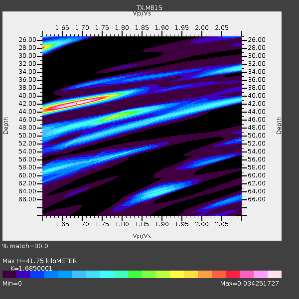
| Crust2 Type: | P5,orogen/45km, Orogen, 4 km seds. |
| Thickness Estimate: | 42 km |
| Thickness StdDev: | 9.9 km |
| Vp/Vs Estimate: | 1.69 |
| Vp/Vs StdDev: | 0.11 |
| Vs Estimate: | 3.637 km/s |
| Poisson's Ratio: | 0.23 |
| Peak Value: | 0.03 |
| Assumed Vp: | 6.129 km/s |
| Ps Weight: | 0.33333334 |
| PpPs Weight: | 0.33333334 |
| PsPs Weight: | 0.33333328 |
| Residual Complexity: | 0.743 |
| Nearby stations H: | +- |
| (2.0 deg) Vp/Vs: | +- |
2 with match > 90% ( 6.060606 %) and 4 with match > 80% ( 12.121212 %) out of 33.
Download stack as xyz text file.
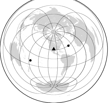
Azimuth Distribution of Events:
Prior Results for this Station
| Study | Thickness | Vp/Vs | Vp | Vs | Poissons Ratio | Extra |
| EARS | 42 km | 1.69 | 6.129 km/s | 3.637 km/s | 0.23 | |
| Crust2.0 | 45 km | 1.76 | 6.129 km/s | 3.476 km/s | 0.26 | P5,orogen/45km, Orogen, 4 km seds. |
| Global Maxima | 42 km | 1.69 | 6.129 km/s | 3.637 km/s | 0.23 | amp=0.034251727 |
| Local Maxima 1 | 28 km | 1.60 | 6.129 km/s | 3.831 km/s | 0.18 | amp=0.028002996 |
| Local Maxima 2 | 45 km | 1.77 | 6.129 km/s | 3.463 km/s | 0.27 | amp=0.021261165 |
| Local Maxima 3 | 64 km | 1.89 | 6.129 km/s | 3.239 km/s | 0.31 | amp=0.014389211 |
| Local Maxima 4 | 45 km | 1.90 | 6.129 km/s | 3.221 km/s | 0.31 | amp=0.013898985 |
| Predicted Arrivals for vertical incidence (zero ray parameter) | |
| Ps | 4.67 SECOND |
| PpPs | 18.29 SECOND |
| PsPs/PpSs | 22.96 SECOND |
Events Processed for this Station
Download zip of receiver functions as SAC
Plot maxima for each earthquake.
Events Used in the Stack
(4 events)| Radial Match | Distance | Baz | FERegion | Time | Lat/Lon | Depth | Magnitude |
| 94.610054 | 86.5 deg | 244.565 deg | Tonga Islands | 2024/05/26 20:47:09 UTC | (-19.4, -174.9) | 112 km | 6.6 mww |
| 93.82778 | 42.3 deg | 111.566 deg | Near Coast Of Venezuela | 2024/06/23 03:58:00 UTC | (10.8, -62.6) | 87 km | 6.0 mww |
| 89.75609 | 54.8 deg | 146.766 deg | Near Coast Of Peru | 2024/06/28 05:36:37 UTC | (-15.8, -74.4) | 28 km | 7.2 mww |
| 86.50977 | 50.4 deg | 76.519 deg | Northern Mid-Atlantic Ridge | 2024/06/03 06:41:51 UTC | (29.6, -42.8) | 10 km | 5.9 mww |
Losers
(29 events)| Radial Match | Distance | Baz | FERegion | Time | Lat/Lon | Depth | Magnitude | Reason |
| 86.86766 | 82.5 deg | 247.036 deg | Tonga Islands | 2023/08/08 18:38:56 UTC | (-15.0, -173.0) | 120 km | 6.2 Mi | |
| 73.67213 | 54.8 deg | 146.927 deg | Near Coast Of Peru | 2024/06/16 14:47:31 UTC | (-15.9, -74.5) | 20 km | 6.0 mww | |
| 73.39681 | 70.8 deg | 143.984 deg | Santiago Del Estero Prov., Arg. | 2023/08/05 07:20:07 UTC | (-28.2, -63.2) | 598 km | 6.2 Mww | |
| 72.6767 | 91.1 deg | 245.132 deg | Fiji Islands Region | 2023/08/02 01:32:35 UTC | (-21.6, -179.3) | 632 km | 5.8 mww | |
| 67.34572 | 96.2 deg | 308.317 deg | Bonin Islands, Japan Region | 2024/04/27 08:35:34 UTC | (27.8, 139.6) | 503 km | 6.5 mww | |
| 67.113235 | 84.0 deg | 246.274 deg | Tonga Islands | 2024/06/18 06:40:36 UTC | (-16.5, -173.8) | 35 km | 5.9 mww | |
| 67.10084 | 87.2 deg | 245.12 deg | Tonga Islands | 2024/05/05 07:13:39 UTC | (-19.4, -175.9) | 10 km | 5.7 mww | |
| 66.34347 | 52.6 deg | 314.265 deg | Fox Islands, Aleutian Islands | 2023/10/12 02:41:11 UTC | (52.6, -171.2) | 125 km | 5.5 ml | |
| 65.44174 | 97.6 deg | 298.155 deg | Mariana Islands | 2024/04/05 11:03:16 UTC | (19.1, 145.4) | 222 km | 6.8 mww | |
| 65.28943 | 41.3 deg | 145.0 deg | Near Coast Of Ecuador | 2023/08/21 05:24:12 UTC | (-3.3, -79.9) | 60 km | 5.5 Mww | |
| 65.1661 | 36.2 deg | 182.711 deg | Central East Pacific Rise | 2024/05/13 02:46:59 UTC | (-4.0, -103.8) | 10 km | 5.3 Mww | |
| 63.90208 | 46.5 deg | 316.738 deg | Alaska Peninsula | 2023/08/03 19:33:51 UTC | (54.7, -161.0) | 41 km | 5.6 mww | |
| 62.55165 | 86.2 deg | 315.197 deg | Off East Coast Of Honshu, Japan | 2023/08/24 22:48:26 UTC | (39.6, 143.3) | 35 km | 5.8 Mww | |
| 61.778347 | 59.8 deg | 5.044 deg | North Of Svalbard | 2024/05/19 02:31:21 UTC | (85.2, 12.1) | 10 km | 5.4 mww | |
| 61.23568 | 94.8 deg | 238.55 deg | Kermadec Islands, New Zealand | 2024/05/17 20:58:27 UTC | (-29.1, -178.5) | 196 km | 5.8 Mww | |
| 60.776295 | 91.1 deg | 316.755 deg | Near West Coast Of Honshu, Japan | 2024/06/02 21:31:38 UTC | (37.5, 137.2) | 4.8 km | 5.8 mww | |
| 59.53457 | 85.3 deg | 245.265 deg | Tonga Islands | 2024/04/05 20:32:13 UTC | (-18.1, -174.3) | 119 km | 5.6 Mww | |
| 59.03513 | 96.0 deg | 306.004 deg | Bonin Islands, Japan Region | 2024/05/21 00:39:37 UTC | (26.2, 141.4) | 38 km | 5.4 Mww | |
| 57.08302 | 33.7 deg | 104.212 deg | Mona Passage | 2024/05/15 00:30:11 UTC | (19.3, -67.4) | 7.0 km | 4.8 Mww | |
| 56.987385 | 68.9 deg | 174.069 deg | West Chile Rise | 2024/06/04 18:32:56 UTC | (-36.6, -95.3) | 10 km | 5.5 Mwb | |
| 56.335335 | 88.4 deg | 247.665 deg | Fiji Islands Region | 2024/06/04 10:00:02 UTC | (-18.0, -178.4) | 586 km | 5.6 Mww | |
| 56.149258 | 96.6 deg | 237.141 deg | Kermadec Islands Region | 2024/04/25 05:07:36 UTC | (-31.3, -179.3) | 179 km | 5.5 mww | |
| 53.807472 | 52.5 deg | 313.627 deg | Fox Islands, Aleutian Islands | 2024/05/19 09:35:24 UTC | (52.2, -170.9) | 28 km | 6.0 mww | |
| 48.03939 | 69.7 deg | 173.599 deg | West Chile Rise | 2024/06/04 18:32:59 UTC | (-37.3, -94.6) | 10 km | 5.5 Mww | |
| 47.47559 | 69.6 deg | 96.534 deg | Central Mid-Atlantic Ridge | 2024/02/12 04:11:10 UTC | (5.5, -32.8) | 10 km | 5.5 Mww | |
| 47.136574 | 89.7 deg | 191.661 deg | Southern East Pacific Rise | 2024/05/18 23:57:41 UTC | (-55.9, -123.2) | 10 km | 5.9 Mww | |
| 42.779415 | 94.4 deg | 312.819 deg | Southeast Of Honshu, Japan | 2024/05/29 17:14:58 UTC | (32.3, 137.6) | 392 km | 5.5 Mww | |
| 41.62935 | 90.2 deg | 198.202 deg | Pacific-Antarctic Ridge | 2024/06/09 09:55:49 UTC | (-53.9, -134.0) | 10 km | 6.2 mww | |
| 19.302765 | 88.2 deg | 314.468 deg | Near East Coast Of Honshu, Japan | 2024/04/04 03:16:31 UTC | (37.7, 141.9) | 40 km | 6.1 Mww |

