
Station TX MB21 - Endeavor
Network: TX - Texas Seismological Network
Nearby stations (2 deg radius)
| Station | Name | (Lat, Lon) | Start / End | Elevation |
| MB21 | Endeavor | (32.34, -101.73) | 2023-07-11 / 2499-01-01 | 999 m |
| Crust2 Type: | D8,thick Platform 3 km seds. |
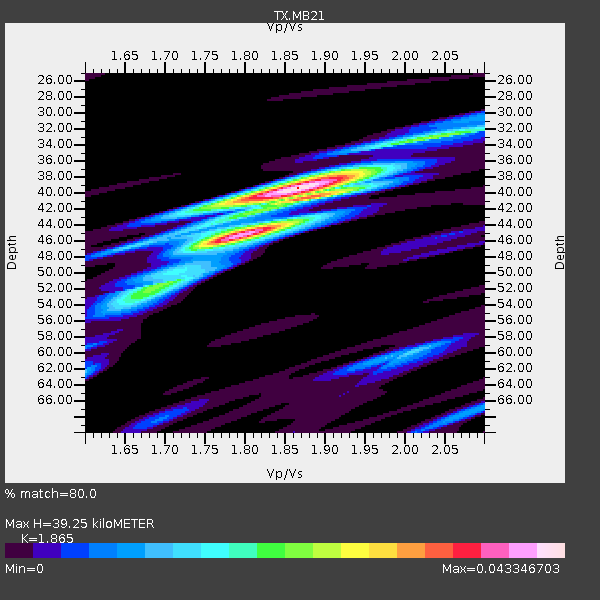
| Thickness Estimate: | 44 km |
| Thickness StdDev: | 3.3 km |
| Vp/Vs Estimate: | 1.79 |
| Vp/Vs StdDev: | 0.04 |
| Vs Estimate: | 3.59 km/s |
| Poisson's Ratio: | 0.27 |
| Peak Value: | 0.05 |
| Assumed Vp: | 6.426 km/s |
| Ps Weight: | 0.33333334 |
| PpPs Weight: | 0.33333334 |
| PsPs Weight: | 0.33333328 |
| Residual Complexity: | 0.492 |
| Nearby stations H: | +- |
| (2.0 deg) Vp/Vs: | +- |
2 with match > 90% ( 8.0 %) and 5 with match > 80% ( 20.0 %) out of 25.
Download stack as xyz text file.
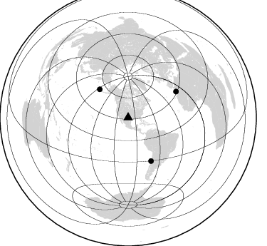
Azimuth Distribution of Events:
Prior Results for this Station
| Study | Thickness | Vp/Vs | Vp | Vs | Poissons Ratio | Extra |
| EARS | 44 km | 1.79 | 6.426 km/s | 3.59 km/s | 0.27 | |
| Crust2.0 | 46 km | 1.78 | 6.426 km/s | 3.613 km/s | 0.27 | D8,thick Platform 3 km seds. |
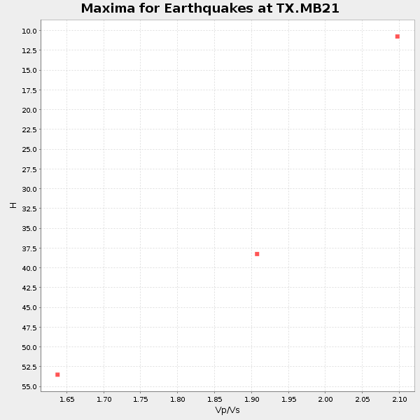
| Global Maxima | 44 km | 1.79 | 6.426 km/s | 3.59 km/s | 0.27 | amp=0.04562894 |
| Local Maxima 1 | 39 km | 1.88 | 6.426 km/s | 3.418 km/s | 0.30 | amp=0.022892918 |
| Local Maxima 2 | 33 km | 2.03 | 6.426 km/s | 3.162 km/s | 0.34 | amp=0.01661951 |
| Local Maxima 3 | 52 km | 1.67 | 6.426 km/s | 3.842 km/s | 0.22 | amp=0.013725114 |
| Local Maxima 4 | 30 km | 2.10 | 6.426 km/s | 3.064 km/s | 0.35 | amp=0.00881779 |
| Predicted Arrivals for vertical incidence (zero ray parameter) | |
| Ps | 5.44 SECOND |
| PpPs | 19.21 SECOND |
| PsPs/PpSs | 24.65 SECOND |
Events Processed for this Station
Download zip of receiver functions as SAC
Plot maxima for each earthquake.
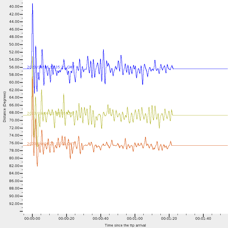
Events Used in the Stack
(5 events)| Radial Match | Distance | Baz | FERegion | Time | Lat/Lon | Depth | Magnitude |
| 97.49998 | 76.6 deg | 61.683 deg | Morocco | 2023/09/08 22:11:01 UTC | (31.1, -8.4) | 19 km | 6.8 mww |
| 94.64844 | 54.5 deg | 147.2 deg | Near Coast Of Peru | 2024/06/28 05:36:37 UTC | (-15.8, -74.4) | 28 km | 7.2 mww |
| 87.52944 | 41.9 deg | 111.9 deg | Near Coast Of Venezuela | 2024/06/23 03:58:00 UTC | (10.8, -62.6) | 87 km | 6.0 mww |
| 85.51767 | 56.4 deg | 314.714 deg | Andreanof Islands, Aleutian Is. | 2023/10/16 11:35:31 UTC | (52.4, -176.9) | 187 km | 6.4 Mww |
| 84.70607 | 68.5 deg | 152.132 deg | Near Coast Of Central Chile | 2023/09/06 23:48:05 UTC | (-30.3, -71.5) | 41 km | 6.2 mww |
Losers
(20 events)| Radial Match | Distance | Baz | FERegion | Time | Lat/Lon | Depth | Magnitude | Reason |
| 86.88315 | 86.7 deg | 245.327 deg | Tonga Islands | 2024/01/18 22:12:20 UTC | (-18.9, -175.1) | 218 km | 6.4 Mww | |
| 77.69663 | 86.1 deg | 246.288 deg | Tonga Islands | 2023/11/19 23:15:47 UTC | (-17.7, -175.2) | 240 km | 5.5 Mww | |
| 75.70449 | 94.8 deg | 237.604 deg | Kermadec Islands, New Zealand | 2023/10/23 10:10:15 UTC | (-29.9, -177.5) | 23 km | 6.0 Mww | |
| 64.66641 | 66.5 deg | 141.906 deg | Salta Province, Argentina | 2023/10/10 00:13:15 UTC | (-23.6, -63.7) | 538 km | 5.6 Mww | |
| 64.519485 | 95.3 deg | 201.8 deg | Pacific-Antarctic Ridge | 2024/03/19 18:07:02 UTC | (-56.4, -143.5) | 10 km | 5.5 Mww | |
| 63.157505 | 97.2 deg | 299.088 deg | Mariana Islands | 2023/11/25 15:10:53 UTC | (20.1, 145.6) | 10 km | 5.5 Mww | |
| 62.070526 | 87.0 deg | 316.639 deg | Near East Coast Of Honshu, Japan | 2024/04/01 19:24:36 UTC | (40.1, 141.7) | 73 km | 5.9 mww | |
| 60.985397 | 92.9 deg | 309.626 deg | Southeast Of Honshu, Japan | 2023/09/21 21:22:12 UTC | (31.0, 141.8) | 13 km | 5.7 Mww | |
| 60.442024 | 84.0 deg | 247.539 deg | Tonga Islands | 2023/10/10 07:21:32 UTC | (-15.5, -174.2) | 25 km | 5.7 Mww | |
| 59.39498 | 68.0 deg | 149.059 deg | La Rioja Province, Argentina | 2024/01/03 08:04:01 UTC | (-28.5, -68.9) | 155 km | 5.5 mww | |
| 59.031277 | 96.5 deg | 249.476 deg | Vanuatu Islands Region | 2024/03/27 01:28:18 UTC | (-20.9, 173.8) | 10 km | 6.7 Mi | |
| 56.24524 | 87.9 deg | 244.98 deg | Tonga Islands | 2024/03/31 03:01:44 UTC | (-19.9, -176.0) | 10 km | 5.5 Mww | |
| 54.774643 | 96.7 deg | 237.265 deg | Kermadec Islands Region | 2024/03/19 02:25:31 UTC | (-31.3, -179.1) | 9.2 km | 5.5 Mww | |
| 54.492702 | 79.4 deg | 316.766 deg | Kuril Islands | 2023/11/08 08:16:29 UTC | (45.0, 149.8) | 68 km | 5.6 mb | |
| 53.809967 | 93.6 deg | 244.351 deg | South Of Fiji Islands | 2023/10/22 19:31:43 UTC | (-23.7, 179.4) | 537 km | 5.5 Mww | |
| 52.25777 | 86.1 deg | 317.155 deg | Hokkaido, Japan Region | 2023/11/19 21:01:31 UTC | (41.2, 142.2) | 53 km | 6.0 Mww | |
| 50.075638 | 52.9 deg | 314.329 deg | Fox Islands, Aleutian Islands | 2023/10/12 02:41:11 UTC | (52.6, -171.2) | 125 km | 5.5 ml | |
| 49.59663 | 69.3 deg | 96.765 deg | Central Mid-Atlantic Ridge | 2024/02/12 04:11:10 UTC | (5.5, -32.8) | 10 km | 5.5 Mww | |
| 47.89418 | 92.8 deg | 309.562 deg | Southeast Of Honshu, Japan | 2023/09/19 06:22:36 UTC | (31.0, 142.0) | 10 km | 5.8 mww | |
| 44.36399 | 80.2 deg | 97.722 deg | Central Mid-Atlantic Ridge | 2023/11/06 12:04:21 UTC | (-1.2, -24.1) | 10 km | 5.5 Mww |

