
Station TX MB22 - Rockfish
Network: TX - Texas Seismological Network
Nearby stations (2 deg radius)
| Station | Name | (Lat, Lon) | Start / End | Elevation |
| MB22 | Rockfish | (32.52, -101.72) | 2022-07-11 / 2499-01-01 | 857 m |
| Crust2 Type: | D8,thick Platform 3 km seds. |
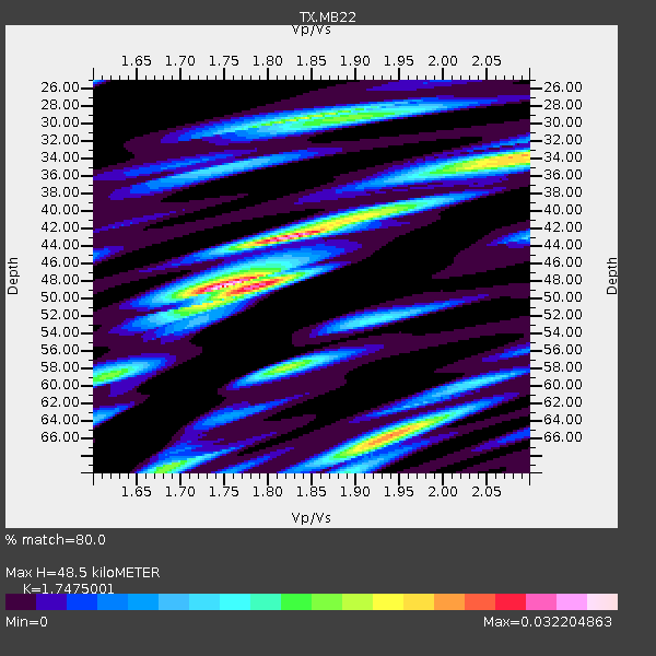
| Thickness Estimate: | 48 km |
| Thickness StdDev: | 6.4 km |
| Vp/Vs Estimate: | 1.78 |
| Vp/Vs StdDev: | 0.06 |
| Vs Estimate: | 3.605 km/s |
| Poisson's Ratio: | 0.27 |
| Peak Value: | 0.03 |
| Assumed Vp: | 6.426 km/s |
| Ps Weight: | 0.33333334 |
| PpPs Weight: | 0.33333334 |
| PsPs Weight: | 0.33333328 |
| Residual Complexity: | 0.677 |
| Nearby stations H: | +- |
| (2.0 deg) Vp/Vs: | +- |
0 with match > 90% ( 0.0 %) and 4 with match > 80% ( 25.0 %) out of 16.
Download stack as xyz text file.
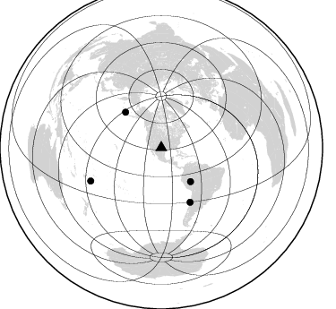
Azimuth Distribution of Events:
Prior Results for this Station
| Study | Thickness | Vp/Vs | Vp | Vs | Poissons Ratio | Extra |
| EARS | 48 km | 1.78 | 6.426 km/s | 3.605 km/s | 0.27 | |
| Crust2.0 | 46 km | 1.78 | 6.426 km/s | 3.613 km/s | 0.27 | D8,thick Platform 3 km seds. |
| Global Maxima | 48 km | 1.78 | 6.426 km/s | 3.605 km/s | 0.27 | amp=0.032326564 |
| Local Maxima 1 | 43 km | 1.82 | 6.426 km/s | 3.541 km/s | 0.28 | amp=0.016812805 |
| Local Maxima 2 | 29 km | 1.87 | 6.426 km/s | 3.432 km/s | 0.30 | amp=0.015407139 |
| Local Maxima 3 | 39 km | 1.97 | 6.426 km/s | 3.27 km/s | 0.33 | amp=0.014430594 |
| Local Maxima 4 | 34 km | 2.08 | 6.426 km/s | 3.097 km/s | 0.35 | amp=0.011539456 |
| Predicted Arrivals for vertical incidence (zero ray parameter) | |
| Ps | 5.91 SECOND |
| PpPs | 21.00 SECOND |
| PsPs/PpSs | 26.91 SECOND |
Events Processed for this Station
Download zip of receiver functions as SAC
Plot maxima for each earthquake.
Events Used in the Stack
(4 events)| Radial Match | Distance | Baz | FERegion | Time | Lat/Lon | Depth | Magnitude |
| 89.5643 | 56.2 deg | 314.632 deg | Andreanof Islands, Aleutian Is. | 2023/10/16 11:35:31 UTC | (52.4, -176.9) | 187 km | 6.4 Mww |
| 88.62529 | 68.7 deg | 152.169 deg | Near Coast Of Central Chile | 2023/09/06 23:48:05 UTC | (-30.3, -71.5) | 41 km | 6.2 mww |
| 87.04394 | 49.8 deg | 139.073 deg | Western Brazil | 2024/01/28 09:38:56 UTC | (-8.2, -71.4) | 609 km | 6.5 Mww |
| 86.84673 | 86.9 deg | 244.805 deg | Tonga Islands | 2024/05/26 20:47:09 UTC | (-19.4, -174.9) | 112 km | 6.6 mww |
Losers
(12 events)| Radial Match | Distance | Baz | FERegion | Time | Lat/Lon | Depth | Magnitude | Reason |
| 83.30998 | 86.8 deg | 245.322 deg | Tonga Islands | 2024/01/18 22:12:20 UTC | (-18.9, -175.1) | 218 km | 6.4 Mww | |
| 72.865555 | 49.0 deg | 138.564 deg | Western Brazil | 2024/01/20 21:31:07 UTC | (-7.3, -71.5) | 629 km | 6.5 Mww | |
| 72.35208 | 46.3 deg | 316.984 deg | Alaska Peninsula | 2023/09/21 01:13:58 UTC | (54.9, -160.3) | 24 km | 5.5 ml | |
| 69.56155 | 94.6 deg | 309.915 deg | Southeast Of Honshu, Japan | 2023/10/04 00:13:45 UTC | (30.0, 140.1) | 10 km | 5.5 Mww | |
| 67.16975 | 96.8 deg | 246.1 deg | South Of Fiji Islands | 2023/09/05 00:55:24 UTC | (-23.9, 175.5) | 12 km | 5.7 Mww | |
| 65.93052 | 89.0 deg | 248.568 deg | Fiji Islands Region | 2023/10/31 11:10:56 UTC | (-17.5, -179.0) | 548 km | 6.4 mww | |
| 65.85802 | 86.9 deg | 242.929 deg | Tonga Islands | 2023/12/24 14:52:55 UTC | (-20.9, -173.8) | 10 km | 5.4 Mww | |
| 59.87144 | 91.7 deg | 317.014 deg | Near West Coast Of Honshu, Japan | 2024/01/01 07:18:42 UTC | (37.2, 136.9) | 10 km | 6.2 mb | |
| 53.24407 | 92.8 deg | 309.636 deg | Southeast Of Honshu, Japan | 2023/09/21 21:22:12 UTC | (31.0, 141.8) | 13 km | 5.7 Mww | |
| 49.550323 | 87.5 deg | 315.541 deg | Near East Coast Of Honshu, Japan | 2023/09/08 09:28:50 UTC | (39.0, 142.1) | 54 km | 5.5 mb | |
| 49.258602 | 95.2 deg | 238.779 deg | Kermadec Islands, New Zealand | 2024/05/17 20:58:27 UTC | (-29.1, -178.5) | 196 km | 5.8 Mww | |
| 45.11999 | 67.5 deg | 151.491 deg | Near Coast Of Central Chile | 2024/02/14 01:31:41 UTC | (-28.9, -71.5) | 22 km | 6.0 mww |

