
Station TX PB20 - Ringtail SWD
Network: TX - Texas Seismological Network
Nearby stations (2 deg radius)
| Station | Name | (Lat, Lon) | Start / End | Elevation |
| PB20 | Ringtail SWD | (31.63, -104.06) | 2022-07-10 / 2499-01-01 | 1022 m |
| Crust2 Type: | X1,Rift, Rio Grande, Baikal, 2km sediments |
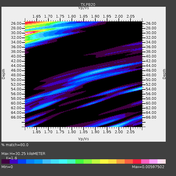
| Thickness Estimate: | 31 km |
| Thickness StdDev: | 8.5 km |
| Vp/Vs Estimate: | 1.60 |
| Vp/Vs StdDev: | 0.09 |
| Vs Estimate: | 3.969 km/s |
| Poisson's Ratio: | 0.18 |
| Peak Value: | 0.01 |
| Assumed Vp: | 6.361 km/s |
| Ps Weight: | 0.33333334 |
| PpPs Weight: | 0.33333334 |
| PsPs Weight: | 0.33333328 |
| Residual Complexity: | 0.735 |
| Nearby stations H: | +- |
| (2.0 deg) Vp/Vs: | +- |
8 with match > 90% ( 34.782608 %) and 11 with match > 80% ( 47.826088 %) out of 23.
Download stack as xyz text file.
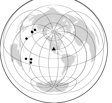
Azimuth Distribution of Events:
Prior Results for this Station
| Study | Thickness | Vp/Vs | Vp | Vs | Poissons Ratio | Extra |
| EARS | 31 km | 1.60 | 6.361 km/s | 3.969 km/s | 0.18 | |
| Crust2.0 | 33 km | 1.77 | 6.361 km/s | 3.594 km/s | 0.27 | X1,Rift, Rio Grande, Baikal, 2km sediments |
| Global Maxima | 31 km | 1.60 | 6.361 km/s | 3.969 km/s | 0.18 | amp=0.012051969 |
| Local Maxima 1 | 28 km | 1.72 | 6.361 km/s | 3.693 km/s | 0.25 | amp=0.008286495 |
| Local Maxima 2 | 26 km | 1.60 | 6.361 km/s | 3.975 km/s | 0.18 | amp=0.008023103 |
| Local Maxima 3 | 34 km | 1.60 | 6.361 km/s | 3.975 km/s | 0.18 | amp=0.0059691537 |
| Local Maxima 4 | 56 km | 1.99 | 6.361 km/s | 3.192 km/s | 0.33 | amp=0.005754804 |
| Predicted Arrivals for vertical incidence (zero ray parameter) | |
| Ps | 2.94 SECOND |
| PpPs | 12.68 SECOND |
| PsPs/PpSs | 15.62 SECOND |
Events Processed for this Station
Download zip of receiver functions as SAC
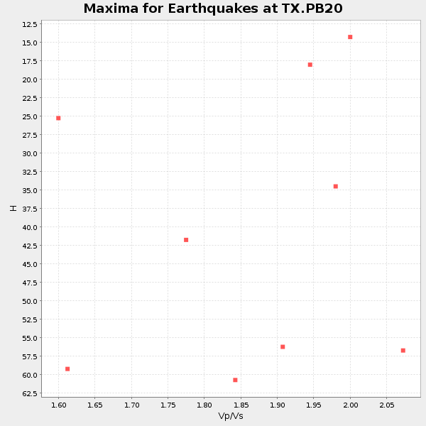
Plot maxima for each earthquake.
Events Used in the Stack
(11 events)| Radial Match | Distance | Baz | FERegion | Time | Lat/Lon | Depth | Magnitude |
| 99.56788 | 93.6 deg | 308.54 deg | Southeast Of Honshu, Japan | 2023/10/04 00:13:45 UTC | (30.0, 140.1) | 10 km | 5.5 Mww |
| 99.55319 | 97.2 deg | 254.427 deg | Vanuatu Islands | 2024/05/25 22:23:16 UTC | (-17.1, 167.9) | 29 km | 6.3 mww |
| 98.11553 | 88.6 deg | 239.973 deg | South Of Fiji Islands | 2023/08/16 16:00:22 UTC | (-24.6, -176.0) | 29 km | 5.5 Mww |
| 97.99761 | 82.6 deg | 246.116 deg | Tonga Islands | 2024/02/18 07:29:19 UTC | (-16.1, -174.6) | 212 km | 5.6 mww |
| 97.81845 | 98.2 deg | 291.104 deg | South Of Mariana Islands | 2023/08/14 13:51:54 UTC | (13.4, 147.5) | 10 km | 6.1 mww |
| 97.591545 | 98.1 deg | 250.972 deg | Loyalty Islands | 2023/12/24 01:59:40 UTC | (-20.5, 168.9) | 10 km | 5.8 mww |
| 95.9595 | 91.7 deg | 308.26 deg | Southeast Of Honshu, Japan | 2023/09/19 06:22:36 UTC | (31.0, 142.0) | 10 km | 5.8 mww |
| 90.56932 | 94.3 deg | 235.593 deg | Kermadec Islands Region | 2024/05/12 18:43:20 UTC | (-31.5, -178.5) | 23 km | 5.8 Mww |
| 89.67731 | 90.6 deg | 315.782 deg | Near West Coast Of Honshu, Japan | 2024/01/01 07:10:10 UTC | (37.5, 137.2) | 0.0 km | 7.4 Mi |
| 86.94057 | 90.5 deg | 315.766 deg | Near West Coast Of Honshu, Japan | 2024/01/01 07:06:05 UTC | (37.5, 137.2) | 10 km | 5.5 mww |
| 83.004074 | 90.4 deg | 315.728 deg | Near West Coast Of Honshu, Japan | 2024/01/01 09:03:49 UTC | (37.6, 137.4) | 10 km | 5.5 mb |
Losers
(12 events)| Radial Match | Distance | Baz | FERegion | Time | Lat/Lon | Depth | Magnitude | Reason |
| 99.18757 | 66.9 deg | 95.559 deg | Central Mid-Atlantic Ridge | 2023/10/14 08:29:34 UTC | (7.5, -36.7) | 10 km | 5.5 Mww | |
| 98.95371 | 90.1 deg | 198.376 deg | Pacific-Antarctic Ridge | 2023/08/06 04:04:27 UTC | (-54.3, -136.6) | 10 km | 5.5 Mww | |
| 98.674995 | 65.9 deg | 142.725 deg | Salta Province, Argentina | 2023/12/11 18:36:00 UTC | (-24.1, -66.8) | 195 km | 5.5 Mww | |
| 98.6631 | 36.2 deg | 182.479 deg | Central East Pacific Rise | 2023/09/09 03:09:49 UTC | (-4.7, -105.5) | 10 km | 5.8 Mww | |
| 97.23824 | 85.3 deg | 188.559 deg | Southern East Pacific Rise | 2023/12/27 21:33:18 UTC | (-53.1, -118.3) | 10 km | 5.7 mww | |
| 97.21045 | 65.2 deg | 141.449 deg | Jujuy Province, Argentina | 2023/10/10 10:01:31 UTC | (-22.9, -66.2) | 247 km | 6.0 Mww | |
| 96.97871 | 41.6 deg | 142.019 deg | Near Coast Of Ecuador | 2023/08/21 05:24:12 UTC | (-3.3, -79.9) | 60 km | 5.5 Mww | |
| 93.43872 | 85.4 deg | 93.338 deg | Central Mid-Atlantic Ridge | 2023/08/18 07:57:57 UTC | (-0.5, -19.7) | 10 km | 5.7 Mww | |
| 88.71171 | 84.6 deg | 244.081 deg | Tonga Islands | 2024/01/18 22:12:20 UTC | (-18.9, -175.1) | 218 km | 6.4 Mww | |
| 83.770775 | 88.2 deg | 313.294 deg | Near East Coast Of Honshu, Japan | 2024/03/16 21:17:04 UTC | (37.1, 141.5) | 45 km | 5.3 Mww | |
| 72.44948 | 68.5 deg | 147.007 deg | La Rioja Province, Argentina | 2024/01/03 08:04:01 UTC | (-28.5, -68.9) | 155 km | 5.5 mww | |
| 71.630356 | 96.5 deg | 296.979 deg | Mariana Islands | 2024/04/05 11:03:16 UTC | (19.1, 145.4) | 222 km | 6.8 mww |

