
Station TX PB36 - UTL Block 46
Network: TX - Texas Seismological Network
Nearby stations (2 deg radius)
| Station | Name | (Lat, Lon) | Start / End | Elevation |
| PB36 | UTL Block 46 | (31.68, -104.43) | 2022-07-27 / 2499-01-01 | 1218 m |
| Crust2 Type: | X1,Rift, Rio Grande, Baikal, 2km sediments |
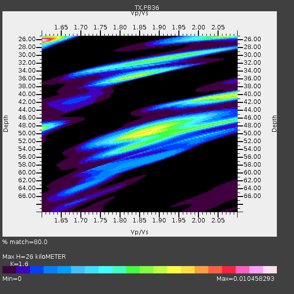
| Thickness Estimate: | 26 km |
| Thickness StdDev: | 11 km |
| Vp/Vs Estimate: | 1.60 |
| Vp/Vs StdDev: | 0.18 |
| Vs Estimate: | 3.975 km/s |
| Poisson's Ratio: | 0.18 |
| Peak Value: | 0.01 |
| Assumed Vp: | 6.361 km/s |
| Ps Weight: | 0.33333334 |
| PpPs Weight: | 0.33333334 |
| PsPs Weight: | 0.33333328 |
| Residual Complexity: | 0.959 |
| Nearby stations H: | +- |
| (2.0 deg) Vp/Vs: | +- |
3 with match > 90% ( 9.67742 %) and 6 with match > 80% ( 19.35484 %) out of 31.
Download stack as xyz text file.
Azimuth Distribution of Events:

Prior Results for this Station
| Study | Thickness | Vp/Vs | Vp | Vs | Poissons Ratio | Extra |
| EARS | 26 km | 1.60 | 6.361 km/s | 3.975 km/s | 0.18 | |
| Crust2.0 | 33 km | 1.77 | 6.361 km/s | 3.594 km/s | 0.27 | X1,Rift, Rio Grande, Baikal, 2km sediments |
| Global Maxima | 26 km | 1.60 | 6.361 km/s | 3.975 km/s | 0.18 | amp=0.010458293 |
| Local Maxima 1 | 50 km | 1.87 | 6.361 km/s | 3.397 km/s | 0.30 | amp=0.0071253404 |
| Local Maxima 2 | 35 km | 1.83 | 6.361 km/s | 3.476 km/s | 0.29 | amp=0.006856875 |
| Local Maxima 3 | 25 km | 2.07 | 6.361 km/s | 3.076 km/s | 0.35 | amp=0.006227648 |
| Local Maxima 4 | 48 km | 1.60 | 6.361 km/s | 3.975 km/s | 0.18 | amp=0.006108872 |
| Predicted Arrivals for vertical incidence (zero ray parameter) | |
| Ps | 2.45 SECOND |
| PpPs | 10.63 SECOND |
| PsPs/PpSs | 13.08 SECOND |
Events Processed for this Station
Download zip of receiver functions as SAC
Plot maxima for each earthquake.
Events Used in the Stack
(6 events)| Radial Match | Distance | Baz | FERegion | Time | Lat/Lon | Depth | Magnitude |
| 97.29432 | 69.1 deg | 149.807 deg | Near Coast Of Central Chile | 2023/09/06 23:48:05 UTC | (-30.3, -71.5) | 41 km | 6.2 mww |
| 91.43324 | 55.2 deg | 314.707 deg | Andreanof Islands, Aleutian Is. | 2023/10/16 11:35:31 UTC | (52.4, -176.9) | 187 km | 6.4 Mww |
| 91.327614 | 67.7 deg | 149.02 deg | Near Coast Of Central Chile | 2023/10/31 12:33:44 UTC | (-28.7, -71.6) | 41 km | 6.7 mww |
| 87.246155 | 49.9 deg | 135.21 deg | Western Brazil | 2024/01/20 21:31:07 UTC | (-7.3, -71.5) | 629 km | 6.5 Mww |
| 82.551216 | 95.4 deg | 234.82 deg | South Of Kermadec Islands | 2023/09/08 09:09:58 UTC | (-32.7, -179.3) | 90 km | 6.6 mww |
| 80.20488 | 71.3 deg | 142.117 deg | Santiago Del Estero Prov., Arg. | 2023/08/05 07:20:07 UTC | (-28.2, -63.2) | 598 km | 6.2 Mww |
Losers
(25 events)| Radial Match | Distance | Baz | FERegion | Time | Lat/Lon | Depth | Magnitude | Reason |
| 94.1169 | 80.4 deg | 245.826 deg | Tonga Islands | 2023/08/08 18:38:56 UTC | (-15.0, -173.0) | 120 km | 6.2 Mi | |
| 77.86444 | 36.9 deg | 129.487 deg | Colombia | 2023/08/27 21:44:59 UTC | (5.3, -76.7) | 15 km | 5.7 Mww | |
| 75.4841 | 78.9 deg | 315.746 deg | Kuril Islands | 2023/12/28 09:15:15 UTC | (44.6, 149.0) | 24 km | 6.5 Mww | |
| 72.61086 | 63.4 deg | 319.513 deg | Komandorskiye Ostrova Region | 2023/08/01 16:49:49 UTC | (54.7, 168.2) | 11 km | 5.7 Mww | |
| 71.82556 | 77.1 deg | 96.925 deg | Central Mid-Atlantic Ridge | 2023/11/21 05:10:26 UTC | (1.0, -29.0) | 10 km | 5.5 Mww | |
| 68.155975 | 51.7 deg | 314.51 deg | Fox Islands, Aleutian Islands | 2023/10/12 02:41:11 UTC | (52.6, -171.2) | 125 km | 5.5 ml | |
| 67.08529 | 84.3 deg | 241.423 deg | Tonga Islands | 2024/01/09 07:53:20 UTC | (-20.9, -173.6) | 10 km | 5.7 mww | |
| 64.17142 | 90.7 deg | 315.537 deg | Near West Coast Of Honshu, Japan | 2024/01/01 07:18:42 UTC | (37.2, 136.9) | 10 km | 6.2 mb | |
| 62.95631 | 97.8 deg | 250.802 deg | Loyalty Islands | 2023/12/24 01:59:40 UTC | (-20.5, 168.9) | 10 km | 5.8 mww | |
| 61.590214 | 82.4 deg | 96.155 deg | Central Mid-Atlantic Ridge | 2023/11/06 12:04:21 UTC | (-1.2, -24.1) | 10 km | 5.5 Mww | |
| 61.23783 | 86.6 deg | 242.766 deg | Fiji Islands Region | 2024/01/04 04:56:36 UTC | (-21.1, -176.4) | 188 km | 5.6 mww | |
| 60.74287 | 86.6 deg | 247.134 deg | Fiji Islands Region | 2023/10/31 11:10:56 UTC | (-17.5, -179.0) | 548 km | 6.4 mww | |
| 60.68321 | 70.2 deg | 141.423 deg | Santiago Del Estero Prov., Arg. | 2023/08/23 14:22:43 UTC | (-26.9, -63.3) | 569 km | 6.2 mww | |
| 60.19845 | 80.7 deg | 245.809 deg | Tonga Islands | 2023/12/12 05:33:10 UTC | (-15.2, -173.3) | 10 km | 5.7 mww | |
| 60.044914 | 87.0 deg | 241.076 deg | Tonga Islands Region | 2023/12/24 02:22:17 UTC | (-22.7, -175.7) | 49 km | 5.3 Mww | |
| 59.311466 | 86.8 deg | 242.282 deg | Fiji Islands Region | 2024/01/18 04:50:01 UTC | (-21.7, -176.3) | 155 km | 5.8 mww | |
| 58.882904 | 97.6 deg | 250.551 deg | Vanuatu Islands | 2023/12/07 12:56:30 UTC | (-20.7, 169.2) | 48 km | 7.1 Mww | |
| 56.383373 | 32.4 deg | 126.273 deg | Panama | 2023/08/29 04:59:19 UTC | (9.9, -78.4) | 10 km | 5.5 mww | |
| 55.829903 | 62.6 deg | 143.903 deg | Near Coast Of Northern Chile | 2023/12/21 16:21:52 UTC | (-21.9, -70.1) | 63 km | 5.6 mww | |
| 51.24145 | 69.5 deg | 318.988 deg | Near East Coast Of Kamchatka | 2023/12/23 17:48:03 UTC | (52.0, 159.0) | 29 km | 5.8 Mww | |
| 50.522522 | 89.8 deg | 315.603 deg | Near West Coast Of Honshu, Japan | 2024/01/09 08:59:10 UTC | (37.9, 137.7) | 11 km | 5.8 Mww | |
| 50.181873 | 71.3 deg | 151.611 deg | Near Coast Of Central Chile | 2023/11/06 13:51:10 UTC | (-33.1, -72.0) | 29 km | 5.2 Mww | |
| 48.44336 | 90.3 deg | 315.575 deg | Near West Coast Of Honshu, Japan | 2024/01/01 07:06:05 UTC | (37.5, 137.2) | 10 km | 5.5 mww | |
| 46.052177 | 87.0 deg | 314.107 deg | Near East Coast Of Honshu, Japan | 2023/09/18 19:33:05 UTC | (38.5, 141.6) | 67 km | 5.5 mww | |
| 40.107674 | 97.4 deg | 253.614 deg | Vanuatu Islands | 2024/01/23 14:33:47 UTC | (-17.9, 167.8) | 10 km | 6.5 Mi |

