
Station TX PB43 - APC/Westernmidstream
Network: TX - Texas Seismological Network
Nearby stations (2 deg radius)
| Station | Name | (Lat, Lon) | Start / End | Elevation |
| PB43 | APC/Westernmidstream | (31.68, -103.86) | 2022-09-23 / 2499-01-01 | 896 m |
| Crust2 Type: | Q1,orogen/39km no ice, Appalachians, North Andes |
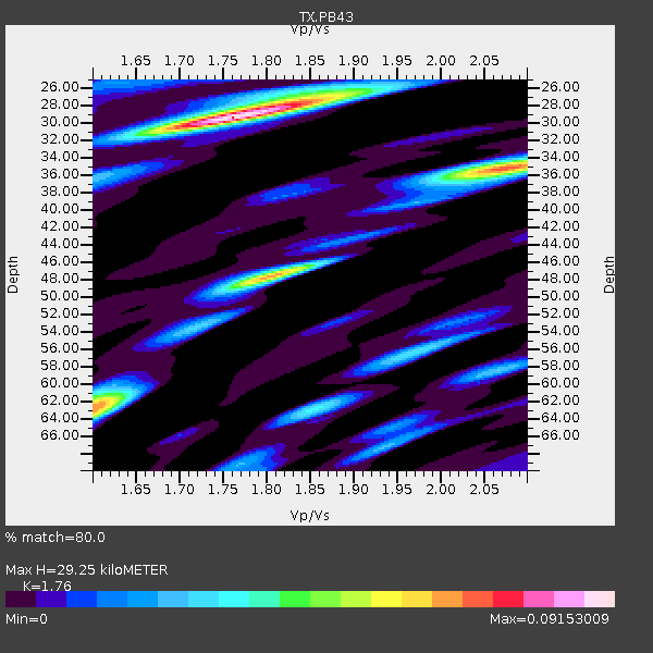
| Thickness Estimate: | 29 km |
| Thickness StdDev: | 0.8 km |
| Vp/Vs Estimate: | 1.76 |
| Vp/Vs StdDev: | 0.01 |
| Vs Estimate: | 3.478 km/s |
| Poisson's Ratio: | 0.26 |
| Peak Value: | 0.09 |
| Assumed Vp: | 6.121 km/s |
| Ps Weight: | 0.33333334 |
| PpPs Weight: | 0.33333334 |
| PsPs Weight: | 0.33333328 |
| Residual Complexity: | 0.714 |
| Nearby stations H: | +- |
| (2.0 deg) Vp/Vs: | +- |
1 with match > 90% ( 12.5 %) and 2 with match > 80% ( 25.0 %) out of 8.
Download stack as xyz text file.
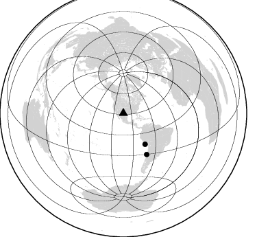
Azimuth Distribution of Events:
Prior Results for this Station
| Study | Thickness | Vp/Vs | Vp | Vs | Poissons Ratio | Extra |
| EARS | 29 km | 1.76 | 6.121 km/s | 3.478 km/s | 0.26 | |
| Crust2.0 | 39 km | 1.76 | 6.121 km/s | 3.485 km/s | 0.26 | Q1,orogen/39km no ice, Appalachians, North Andes |
| Global Maxima | 29 km | 1.76 | 6.121 km/s | 3.478 km/s | 0.26 | amp=0.09153009 |
| Local Maxima 1 | 35 km | 2.08 | 6.121 km/s | 2.946 km/s | 0.35 | amp=0.07106621 |
| Local Maxima 2 | 48 km | 1.80 | 6.121 km/s | 3.396 km/s | 0.28 | amp=0.06388216 |
| Local Maxima 3 | 62 km | 1.61 | 6.121 km/s | 3.813 km/s | 0.18 | amp=0.054419752 |
| Local Maxima 4 | 27 km | 1.86 | 6.121 km/s | 3.295 km/s | 0.30 | amp=0.041450694 |
| Predicted Arrivals for vertical incidence (zero ray parameter) | |
| Ps | 3.63 SECOND |
| PpPs | 13.19 SECOND |
| PsPs/PpSs | 16.82 SECOND |
Events Processed for this Station
Download zip of receiver functions as SAC
Plot maxima for each earthquake.
Events Used in the Stack
(2 events)| Radial Match | Distance | Baz | FERegion | Time | Lat/Lon | Depth | Magnitude |
| 91.80142 | 55.0 deg | 144.749 deg | Near Coast Of Peru | 2024/06/28 05:36:37 UTC | (-15.8, -74.4) | 28 km | 7.2 mww |
| 88.775536 | 68.8 deg | 150.26 deg | Near Coast Of Central Chile | 2023/09/06 23:48:05 UTC | (-30.3, -71.5) | 41 km | 6.2 mww |
Losers
(6 events)| Radial Match | Distance | Baz | FERegion | Time | Lat/Lon | Depth | Magnitude | Reason |
| 79.86175 | 55.5 deg | 314.768 deg | Andreanof Islands, Aleutian Is. | 2023/10/16 11:35:31 UTC | (52.4, -176.9) | 187 km | 6.4 Mww | |
| 78.33765 | 84.9 deg | 243.669 deg | Tonga Islands | 2024/05/26 20:47:09 UTC | (-19.4, -174.9) | 112 km | 6.6 mww | |
| 73.174 | 96.6 deg | 297.096 deg | Mariana Islands | 2024/04/05 11:03:16 UTC | (19.1, 145.4) | 222 km | 6.8 mww | |
| 68.12938 | 84.9 deg | 244.577 deg | Tonga Islands | 2023/12/11 06:33:31 UTC | (-18.7, -175.5) | 238 km | 6.1 Mww | |
| 67.83884 | 49.6 deg | 135.792 deg | Western Brazil | 2024/01/20 21:31:07 UTC | (-7.3, -71.5) | 629 km | 6.5 Mww | |
| 53.045727 | 84.8 deg | 244.187 deg | Tonga Islands | 2024/01/18 22:12:20 UTC | (-18.9, -175.1) | 218 km | 6.4 Mww |

