
Station TX PB44 - W of Red Bluff Resovoir
Network: TX - Texas Seismological Network
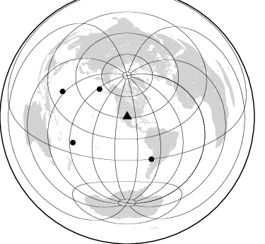
Nearby stations (2 deg radius)
| Station | Name | (Lat, Lon) | Start / End | Elevation |
| PB44 | W of Red Bluff Resovoir | (31.92, -103.99) | 2023-03-08 / 2499-01-01 | 894 m |
| Crust2 Type: | Q1,orogen/39km no ice, Appalachians, North Andes |
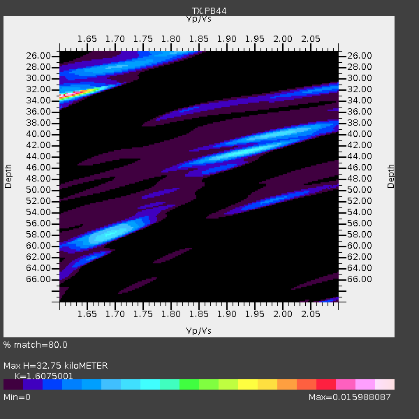
| Thickness Estimate: | 33 km |
| Thickness StdDev: | 12 km |
| Vp/Vs Estimate: | 1.61 |
| Vp/Vs StdDev: | 0.15 |
| Vs Estimate: | 3.813 km/s |
| Poisson's Ratio: | 0.18 |
| Peak Value: | 0.01 |
| Assumed Vp: | 6.121 km/s |
| Ps Weight: | 0.33333334 |
| PpPs Weight: | 0.33333334 |
| PsPs Weight: | 0.33333328 |
| Residual Complexity: | 0.877 |
| Nearby stations H: | +- |
| (2.0 deg) Vp/Vs: | +- |
2 with match > 90% ( 5.0 %) and 6 with match > 80% ( 15.0 %) out of 40.
Download stack as xyz text file.
Azimuth Distribution of Events:
Prior Results for this Station
| Study | Thickness | Vp/Vs | Vp | Vs | Poissons Ratio | Extra |
| EARS | 33 km | 1.61 | 6.121 km/s | 3.813 km/s | 0.18 | |
| Crust2.0 | 39 km | 1.76 | 6.121 km/s | 3.485 km/s | 0.26 | Q1,orogen/39km no ice, Appalachians, North Andes |
| Global Maxima | 33 km | 1.61 | 6.121 km/s | 3.813 km/s | 0.18 | amp=0.012468162 |
| Local Maxima 1 | 57 km | 1.69 | 6.121 km/s | 3.627 km/s | 0.23 | amp=0.0119980015 |
| Local Maxima 2 | 44 km | 1.88 | 6.121 km/s | 3.256 km/s | 0.30 | amp=0.0075546033 |
| Local Maxima 3 | 25 km | 1.81 | 6.121 km/s | 3.377 km/s | 0.28 | amp=0.0059525864 |
| Local Maxima 4 | 39 km | 2.01 | 6.121 km/s | 3.049 km/s | 0.33 | amp=0.005400779 |
| Predicted Arrivals for vertical incidence (zero ray parameter) | |
| Ps | 3.24 SECOND |
| PpPs | 13.94 SECOND |
| PsPs/PpSs | 17.18 SECOND |
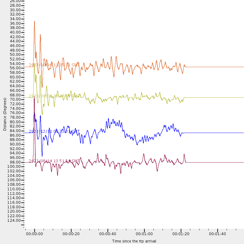
Events Processed for this Station
Download zip of receiver functions as SAC
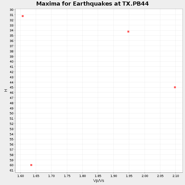
Plot maxima for each earthquake.
Events Used in the Stack
(6 events)| Radial Match | Distance | Baz | FERegion | Time | Lat/Lon | Depth | Magnitude |
| 95.250084 | 55.3 deg | 144.724 deg | Near Coast Of Peru | 2024/06/28 05:36:37 UTC | (-15.8, -74.4) | 28 km | 7.2 mww |
| 94.40017 | 69.1 deg | 150.207 deg | Near Coast Of Central Chile | 2023/09/06 23:48:05 UTC | (-30.3, -71.5) | 41 km | 6.2 mww |
| 88.19668 | 84.9 deg | 243.581 deg | Tonga Islands | 2024/05/26 20:47:09 UTC | (-19.4, -174.9) | 112 km | 6.6 mww |
| 87.74826 | 55.3 deg | 314.635 deg | Andreanof Islands, Aleutian Is. | 2023/10/16 11:35:31 UTC | (52.4, -176.9) | 187 km | 6.4 Mww |
| 82.520805 | 98.1 deg | 291.186 deg | South Of Mariana Islands | 2023/08/14 13:51:54 UTC | (13.4, 147.5) | 10 km | 6.1 mww |
| 81.8906 | 84.9 deg | 244.49 deg | Tonga Islands | 2023/12/11 06:33:31 UTC | (-18.7, -175.5) | 238 km | 6.1 Mww |
Losers
(34 events)| Radial Match | Distance | Baz | FERegion | Time | Lat/Lon | Depth | Magnitude | Reason |
| 82.43287 | 85.6 deg | 188.6 deg | Southern East Pacific Rise | 2023/12/27 21:33:18 UTC | (-53.1, -118.3) | 10 km | 5.7 mww | |
| 79.7355 | 39.6 deg | 127.761 deg | Colombia | 2023/08/17 17:17:18 UTC | (4.2, -73.6) | 7.9 km | 5.7 Mww | |
| 78.42481 | 52.0 deg | 75.489 deg | Northern Mid-Atlantic Ridge | 2024/06/03 06:41:51 UTC | (29.6, -42.8) | 10 km | 5.9 mww | |
| 76.659004 | 43.6 deg | 109.546 deg | Near Coast Of Venezuela | 2024/06/23 03:58:00 UTC | (10.8, -62.6) | 87 km | 6.0 mww | |
| 76.58932 | 36.5 deg | 182.587 deg | Central East Pacific Rise | 2023/09/09 03:09:49 UTC | (-4.7, -105.5) | 10 km | 5.8 Mww | |
| 75.8977 | 96.7 deg | 255.902 deg | Vanuatu Islands | 2023/09/28 14:40:26 UTC | (-15.6, 167.7) | 126 km | 6.0 mww | |
| 75.03703 | 96.4 deg | 297.052 deg | Mariana Islands | 2024/04/05 11:03:16 UTC | (19.1, 145.4) | 222 km | 6.8 mww | |
| 75.03312 | 49.8 deg | 135.809 deg | Western Brazil | 2024/01/20 21:31:07 UTC | (-7.3, -71.5) | 629 km | 6.5 Mww | |
| 71.24661 | 64.9 deg | 18.513 deg | Norwegian Sea | 2023/12/13 20:20:10 UTC | (72.6, 3.5) | 10 km | 5.5 mww | |
| 69.52999 | 79.3 deg | 95.799 deg | Central Mid-Atlantic Ridge | 2023/09/11 09:20:56 UTC | (0.7, -26.1) | 10 km | 5.9 Mww | |
| 67.63781 | 94.5 deg | 235.648 deg | Kermadec Islands Region | 2024/05/12 18:43:20 UTC | (-31.5, -178.5) | 23 km | 5.8 Mww | |
| 66.76125 | 71.3 deg | 142.498 deg | Santiago Del Estero Prov., Arg. | 2023/08/05 07:20:07 UTC | (-28.2, -63.2) | 598 km | 6.2 Mww | |
| 65.60248 | 67.9 deg | 149.484 deg | Near Coast Of Central Chile | 2024/02/14 01:31:41 UTC | (-28.9, -71.5) | 22 km | 6.0 mww | |
| 63.56851 | 35.7 deg | 179.629 deg | Central East Pacific Rise | 2024/05/13 02:46:59 UTC | (-4.0, -103.8) | 10 km | 5.3 Mww | |
| 62.97106 | 95.5 deg | 297.809 deg | Mariana Islands | 2023/12/16 09:50:53 UTC | (20.3, 145.7) | 10 km | 5.7 mww | |
| 62.42835 | 50.8 deg | 313.64 deg | Fox Islands, Aleutian Islands | 2024/05/02 06:58:01 UTC | (52.1, -169.5) | 16 km | 5.5 mww | |
| 61.774693 | 33.1 deg | 327.439 deg | Off Coast Of Southeastern Alaska | 2024/01/12 07:46:21 UTC | (56.5, -136.0) | 0.6 km | 5.9 mww | |
| 61.56763 | 62.8 deg | 142.752 deg | Chile-Bolivia Border Region | 2024/06/01 10:53:06 UTC | (-21.4, -68.7) | 99 km | 5.1 Mww | |
| 58.790897 | 49.5 deg | 312.929 deg | Fox Islands, Aleutian Islands | 2023/08/20 01:48:54 UTC | (51.6, -167.3) | 10 km | 5.2 Mww | |
| 57.891945 | 93.3 deg | 237.615 deg | Kermadec Islands, New Zealand | 2024/05/17 20:58:27 UTC | (-29.1, -178.5) | 196 km | 5.8 Mww | |
| 57.005184 | 96.2 deg | 256.277 deg | Vanuatu Islands | 2023/11/22 04:47:31 UTC | (-15.0, 168.0) | 13 km | 6.7 mww | |
| 56.780556 | 94.2 deg | 200.739 deg | Pacific-Antarctic Ridge | 2024/03/19 18:07:02 UTC | (-56.4, -143.5) | 10 km | 5.5 Mww | |
| 53.79098 | 94.2 deg | 40.718 deg | Southern Greece | 2024/03/29 07:12:47 UTC | (37.3, 21.3) | 25 km | 5.8 Mww | |
| 53.080124 | 90.4 deg | 91.128 deg | North Of Ascension Island | 2024/05/04 05:52:35 UTC | (-1.2, -14.3) | 10 km | 5.4 Mww | |
| 52.300663 | 97.9 deg | 314.896 deg | Kyushu, Japan | 2024/04/08 01:25:29 UTC | (31.7, 131.4) | 54 km | 5.1 Mww | |
| 51.944946 | 87.1 deg | 242.994 deg | Fiji Islands Region | 2024/01/04 04:56:36 UTC | (-21.1, -176.4) | 188 km | 5.6 mww | |
| 51.61688 | 36.8 deg | 130.285 deg | Colombia | 2023/08/27 21:44:59 UTC | (5.3, -76.7) | 15 km | 5.7 Mww | |
| 50.968227 | 91.6 deg | 308.427 deg | Southeast Of Honshu, Japan | 2023/10/04 04:55:47 UTC | (31.1, 141.9) | 10 km | 5.7 mww | |
| 50.515438 | 86.5 deg | 314.432 deg | Near East Coast Of Honshu, Japan | 2023/09/08 09:28:50 UTC | (39.0, 142.1) | 54 km | 5.5 mb | |
| 50.074757 | 96.2 deg | 256.131 deg | Vanuatu Islands | 2024/05/08 08:17:15 UTC | (-15.1, 168.0) | 12 km | 6.1 mww | |
| 47.388096 | 88.3 deg | 244.55 deg | Fiji Islands Region | 2024/03/02 00:26:40 UTC | (-20.6, -178.4) | 537 km | 5.8 mww | |
| 46.289356 | 92.0 deg | 236.924 deg | Kermadec Islands Region | 2024/05/31 15:54:41 UTC | (-29.0, -176.9) | 20 km | 6.2 mww | |
| 44.42755 | 93.0 deg | 252.356 deg | Vanuatu Islands Region | 2024/02/14 18:58:38 UTC | (-16.7, 172.9) | 37 km | 5.5 mww | |
| 39.527157 | 68.7 deg | 147.13 deg | La Rioja Province, Argentina | 2024/01/03 08:04:01 UTC | (-28.5, -68.9) | 155 km | 5.5 mww |

