
Station TZ OLDO - Ol Doinyo Lengai, Tanzania; colocated with TZVOLCANO
Network: TZ - Ol Doinyo Lengai, TZ Volcano Monitoring (TZVOLCANO)
Nearby stations (2 deg radius)
| Station | Name | (Lat, Lon) | Start / End | Elevation |
| OLDO | Ol Doinyo Lengai, Tanzania; colocated with TZVOLCANO | (-2.71, 35.91) | 2018-01-01 / 2022-12-31 | 1138 m |
| Crust2 Type: | I2,late Proter., 1 km seds. |
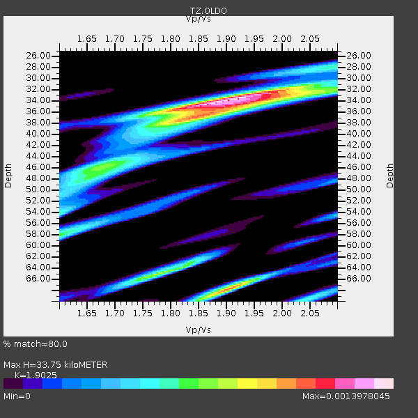
| Thickness Estimate: | 34 km |
| Thickness StdDev: | 9.8 km |
| Vp/Vs Estimate: | 1.90 |
| Vp/Vs StdDev: | 0.11 |
| Vs Estimate: | 3.457 km/s |
| Poisson's Ratio: | 0.31 |
| Peak Value: | 0.00 |
| Assumed Vp: | 6.576 km/s |
| Ps Weight: | 0.33333334 |
| PpPs Weight: | 0.33333334 |
| PsPs Weight: | 0.33333328 |
| Residual Complexity: | 0.634 |
| Nearby stations H: | +- |
| (2.0 deg) Vp/Vs: | +- |
11 with match > 90% ( 22.916666 %) and 12 with match > 80% ( 25.0 %) out of 48.
Download stack as xyz text file.
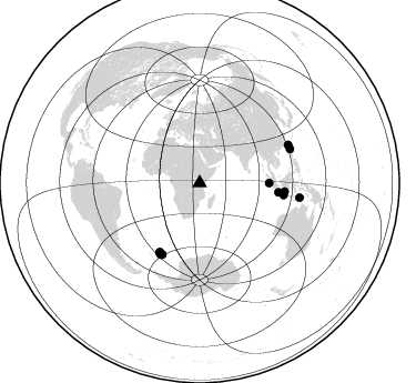
Azimuth Distribution of Events:
Prior Results for this Station
| Study | Thickness | Vp/Vs | Vp | Vs | Poissons Ratio | Extra |
| EARS | 34 km | 1.90 | 6.576 km/s | 3.457 km/s | 0.31 | |
| Crust2.0 | 38 km | 1.78 | 6.576 km/s | 3.695 km/s | 0.27 | I2,late Proter., 1 km seds. |
| Global Maxima | 34 km | 1.90 | 6.576 km/s | 3.457 km/s | 0.31 | amp=0.0013978045 |
| Local Maxima 1 | 68 km | 1.90 | 6.576 km/s | 3.452 km/s | 0.31 | amp=0.0010807223 |
| Local Maxima 2 | 65 km | 1.78 | 6.576 km/s | 3.695 km/s | 0.27 | amp=7.948091E-4 |
| Local Maxima 3 | 36 km | 1.85 | 6.576 km/s | 3.55 km/s | 0.29 | amp=7.641063E-4 |
| Local Maxima 4 | 58 km | 1.60 | 6.576 km/s | 4.11 km/s | 0.18 | amp=6.5138185E-4 |
| Predicted Arrivals for vertical incidence (zero ray parameter) | |
| Ps | 4.63 SECOND |
| PpPs | 14.90 SECOND |
| PsPs/PpSs | 19.53 SECOND |
Events Processed for this Station
Download zip of receiver functions as SAC
Plot maxima for each earthquake.
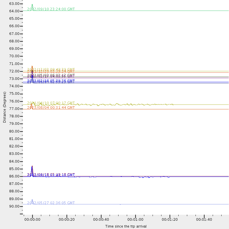
Events Used in the Stack
(12 events)| Radial Match | Distance | Baz | FERegion | Time | Lat/Lon | Depth | Magnitude |
| 100.0 | 71.7 deg | 210.068 deg | South Sandwich Islands Region | 2021/12/20 03:39:34 UTC | (-56.9, -24.1) | 10 km | 6.0 mww |
| 99.99889 | 72.3 deg | 210.11 deg | South Sandwich Islands Region | 2022/05/02 06:02:12 UTC | (-57.1, -25.1) | 10 km | 5.7 Mww |
| 99.99628 | 77.0 deg | 95.622 deg | Java, Indonesia | 2023/08/04 00:31:44 UTC | (-6.1, 113.1) | 578 km | 5.5 mww |
| 99.958496 | 73.1 deg | 208.951 deg | South Sandwich Islands Region | 2022/02/16 05:39:36 UTC | (-58.4, -25.6) | 35 km | 5.5 mww |
| 99.95297 | 71.5 deg | 96.696 deg | Java, Indonesia | 2022/12/03 09:49:39 UTC | (-7.2, 107.6) | 112 km | 5.7 mww |
| 99.938576 | 86.8 deg | 66.781 deg | Taiwan | 2022/09/18 05:19:18 UTC | (23.1, 121.3) | 10 km | 5.6 mww |
| 99.92536 | 62.7 deg | 89.956 deg | Southern Sumatra, Indonesia | 2022/09/10 23:24:00 UTC | (-1.2, 98.6) | 10 km | 5.7 mb |
| 99.91434 | 73.3 deg | 208.528 deg | South Sandwich Islands Region | 2022/06/04 02:59:29 UTC | (-58.8, -25.6) | 47 km | 5.6 mww |
| 99.823204 | 72.5 deg | 207.742 deg | South Sandwich Islands Region | 2022/02/17 04:03:55 UTC | (-59.2, -23.7) | 10 km | 5.5 Mww |
| 99.374504 | 90.9 deg | 98.266 deg | Timor Region | 2022/05/27 02:36:05 UTC | (-8.3, 127.2) | 51 km | 6.1 Mww |
| 95.29538 | 86.9 deg | 69.421 deg | Philippine Islands Region | 2023/08/13 01:43:10 UTC | (20.5, 121.6) | 48 km | 5.4 Mww |
| 81.996376 | 76.4 deg | 98.104 deg | Java, Indonesia | 2021/04/10 07:00:17 UTC | (-8.6, 112.5) | 82 km | 6.0 Mww |
Losers
(36 events)| Radial Match | Distance | Baz | FERegion | Time | Lat/Lon | Depth | Magnitude | Reason |
| 100.0 | 86.1 deg | 97.416 deg | Flores Sea | 2021/12/14 08:31:31 UTC | (-7.6, 122.3) | 10 km | 5.5 Mww | |
| 100.0 | 81.1 deg | 325.339 deg | Reykjanes Ridge | 2022/09/29 15:32:30 UTC | (53.7, -35.2) | 10 km | 5.7 Mww | |
| 100.0 | 60.7 deg | 223.524 deg | Southern Mid-Atlantic Ridge | 2022/11/03 20:59:24 UTC | (-41.1, -16.7) | 10 km | 5.5 Mww | |
| 100.0 | 50.7 deg | 338.966 deg | Central Italy | 2022/11/09 06:07:27 UTC | (43.9, 13.3) | 10 km | 5.6 mww | |
| 100.0 | 73.2 deg | 208.544 deg | South Sandwich Islands Region | 2022/12/11 06:40:20 UTC | (-58.8, -25.4) | 28 km | 5.6 mww | |
| 100.0 | 51.0 deg | 255.703 deg | Southern Mid-Atlantic Ridge | 2023/06/21 04:10:53 UTC | (-12.9, -14.7) | 10 km | 5.5 mww | |
| 99.99999 | 35.7 deg | 143.119 deg | Southwest Indian Ridge | 2023/07/28 07:03:06 UTC | (-30.5, 59.8) | 10 km | 5.6 Mww | |
| 99.999985 | 91.0 deg | 84.071 deg | Mindanao, Philippines | 2022/02/20 18:29:28 UTC | (6.0, 126.7) | 72 km | 5.6 Mww | |
| 99.99994 | 45.9 deg | 184.416 deg | South Of Africa | 2023/06/18 21:59:17 UTC | (-48.6, 31.1) | 10 km | 6.0 Mww | |
| 99.99993 | 73.9 deg | 207.931 deg | South Sandwich Islands Region | 2022/02/25 21:52:05 UTC | (-59.6, -26.3) | 33 km | 5.7 mww | |
| 99.999916 | 34.1 deg | 30.001 deg | Southern Iran | 2022/06/15 06:06:03 UTC | (26.7, 54.2) | 10 km | 5.5 Mww | |
| 99.99989 | 84.5 deg | 97.838 deg | Flores Region, Indonesia | 2022/02/21 16:22:34 UTC | (-8.1, 120.8) | 14 km | 5.5 mww | |
| 99.99973 | 35.7 deg | 143.224 deg | Southwest Indian Ridge | 2023/07/28 07:58:55 UTC | (-30.5, 59.8) | 10 km | 5.9 Mww | |
| 99.9807 | 72.8 deg | 209.203 deg | South Sandwich Islands Region | 2022/05/23 11:58:02 UTC | (-58.0, -25.3) | 23 km | 5.5 Mww | |
| 99.96713 | 71.5 deg | 205.521 deg | East Of South Sandwich Islands | 2022/09/29 03:03:29 UTC | (-60.6, -20.0) | 33 km | 6.7 Mi | |
| 99.95234 | 34.9 deg | 31.225 deg | Southern Iran | 2022/07/01 23:25:15 UTC | (26.9, 55.3) | 10 km | 6.0 Mwb | |
| 99.744514 | 49.7 deg | 32.193 deg | Southeastern Uzbekistan | 2022/05/12 10:27:41 UTC | (38.1, 66.9) | 10 km | 5.4 Mww | |
| 98.98102 | 73.9 deg | 318.353 deg | Northern Mid-Atlantic Ridge | 2023/06/23 21:48:25 UTC | (44.9, -28.1) | 10 km | 5.6 Mww | |
| 97.00323 | 85.9 deg | 72.285 deg | Luzon, Philippines | 2022/07/27 00:43:24 UTC | (17.6, 120.8) | 10 km | 7.0 Mww | |
| 91.77735 | 64.4 deg | 51.194 deg | Qinghai, China | 2022/08/14 08:20:01 UTC | (33.2, 92.8) | 10 km | 5.5 mww | |
| 89.98142 | 71.4 deg | 54.648 deg | Sichuan, China | 2022/06/09 17:28:37 UTC | (32.4, 101.9) | 16 km | 5.9 Mww | |
| 89.00164 | 91.5 deg | 83.55 deg | Philippine Islands Region | 2022/05/04 21:41:08 UTC | (6.6, 127.1) | 35 km | 5.6 Mww | |
| 85.30142 | 85.8 deg | 67.831 deg | Taiwan | 2022/06/28 13:43:29 UTC | (22.0, 120.3) | 10 km | 5.4 Mww | |
| 82.29841 | 88.0 deg | 356.729 deg | North Of Svalbard | 2022/05/21 07:01:23 UTC | (84.3, 0.8) | 10 km | 5.8 mww | |
| 77.15357 | 89.4 deg | 83.371 deg | Mindanao, Philippines | 2022/08/15 08:23:05 UTC | (6.6, 125.0) | 10 km | 5.2 Mww | |
| 76.036545 | 87.5 deg | 89.92 deg | Minahassa Peninsula, Sulawesi | 2022/05/12 07:22:12 UTC | (-0.0, 123.4) | 130 km | 5.1 Mww | |
| 75.29641 | 89.0 deg | 85.866 deg | Celebes Sea | 2021/04/10 09:30:44 UTC | (4.1, 124.7) | 311 km | 6.1 mww | |
| 69.47111 | 40.9 deg | 348.987 deg | Dodecanese Islands, Greece | 2022/08/31 10:10:11 UTC | (37.6, 26.8) | 11 km | 5.5 mww | |
| 69.08364 | 87.8 deg | 89.747 deg | Minahassa Peninsula, Sulawesi | 2022/06/07 13:24:13 UTC | (0.1, 123.7) | 132 km | 5.6 mww | |
| 68.91009 | 66.0 deg | 94.522 deg | Southern Sumatra, Indonesia | 2022/05/16 18:58:23 UTC | (-5.3, 102.0) | 15 km | 5.8 Mww | |
| 66.16017 | 62.7 deg | 89.762 deg | Southern Sumatra, Indonesia | 2022/08/28 22:34:33 UTC | (-1.0, 98.6) | 12 km | 5.8 Mww | |
| 64.12606 | 68.3 deg | 95.23 deg | Southern Sumatra, Indonesia | 2022/05/31 07:10:10 UTC | (-5.9, 104.3) | 71 km | 5.6 mb | |
| 61.746853 | 94.8 deg | 93.736 deg | Seram, Indonesia | 2022/01/19 14:29:43 UTC | (-3.5, 130.9) | 9.3 km | 5.3 Mww | |
| 61.30252 | 80.3 deg | 344.992 deg | Jan Mayen Island Region | 2022/02/14 20:28:21 UTC | (70.7, -14.4) | 10 km | 5.7 Mww | |
| 60.608707 | 80.8 deg | 100.231 deg | South Of Sumbawa, Indonesia | 2021/04/15 10:36:19 UTC | (-10.6, 117.0) | 10 km | 5.4 Mww | |
| 46.090782 | 96.1 deg | 142.208 deg | Western Indian-Antarctic Ridge | 2021/10/30 09:03:22 UTC | (-51.4, 139.1) | 10 km | 5.9 Mww |

