
Station UO GRSDL - Olney, OR, USA
Network: UO - University of Oregon Regional Network
Nearby stations (2 deg radius)
| Station | Name | (Lat, Lon) | Start / End | Elevation |
| GRSDL | Olney, OR, USA | (46.02, -123.71) | 2021-10-12 / 2499-01-01 | 630 m |
| Crust2 Type: | L8,thin continental arc, Cordilleras, 0.5 km seds. |
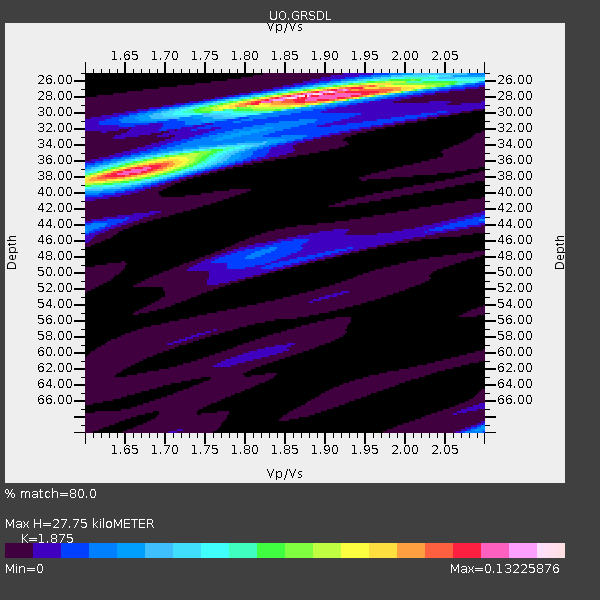
| Thickness Estimate: | 28 km |
| Thickness StdDev: | 5.9 km |
| Vp/Vs Estimate: | 1.88 |
| Vp/Vs StdDev: | 0.11 |
| Vs Estimate: | 3.502 km/s |
| Poisson's Ratio: | 0.30 |
| Peak Value: | 0.13 |
| Assumed Vp: | 6.566 km/s |
| Ps Weight: | 0.33333334 |
| PpPs Weight: | 0.33333334 |
| PsPs Weight: | 0.33333328 |
| Residual Complexity: | 0.611 |
| Nearby stations H: | +- |
| (2.0 deg) Vp/Vs: | +- |
1 with match > 90% ( 3.125 %) and 5 with match > 80% ( 15.625 %) out of 32.
Download stack as xyz text file.
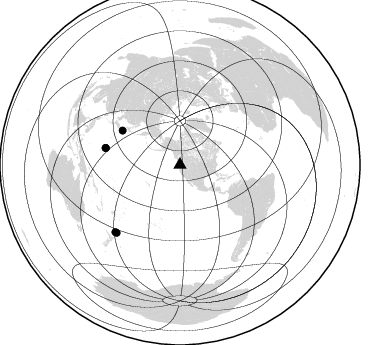
Azimuth Distribution of Events:
Prior Results for this Station
| Study | Thickness | Vp/Vs | Vp | Vs | Poissons Ratio | Extra |
| EARS | 28 km | 1.88 | 6.566 km/s | 3.502 km/s | 0.30 | |
| Crust2.0 | 34 km | 1.77 | 6.566 km/s | 3.707 km/s | 0.27 | L8,thin continental arc, Cordilleras, 0.5 km seds. |
| Global Maxima | 28 km | 1.88 | 6.566 km/s | 3.502 km/s | 0.30 | amp=0.13225876 |
| Local Maxima 1 | 37 km | 1.65 | 6.566 km/s | 3.967 km/s | 0.21 | amp=0.11252418 |
| Local Maxima 2 | 28 km | 1.93 | 6.566 km/s | 3.407 km/s | 0.32 | amp=0.046620086 |
| Local Maxima 3 | 35 km | 1.71 | 6.566 km/s | 3.834 km/s | 0.24 | amp=0.034539077 |
| Local Maxima 4 | 69 km | 2.10 | 6.566 km/s | 3.13 km/s | 0.35 | amp=0.022251887 |
| Predicted Arrivals for vertical incidence (zero ray parameter) | |
| Ps | 3.70 SECOND |
| PpPs | 12.15 SECOND |
| PsPs/PpSs | 15.85 SECOND |
Events Processed for this Station
Download zip of receiver functions as SAC
Plot maxima for each earthquake.
Events Used in the Stack
(5 events)| Radial Match | Distance | Baz | FERegion | Time | Lat/Lon | Depth | Magnitude |
| 92.326935 | 67.0 deg | 300.79 deg | Near East Coast Of Honshu, Japan | 2022/03/16 14:36:33 UTC | (37.7, 141.6) | 63 km | 7.3 mww |
| 84.169785 | 76.2 deg | 282.727 deg | Mariana Islands Region | 2022/07/10 22:19:59 UTC | (18.8, 147.0) | 10 km | 5.6 mww |
| 83.30568 | 76.4 deg | 282.945 deg | Mariana Islands | 2022/07/08 23:36:11 UTC | (18.8, 146.8) | 23 km | 6.3 Mi |
| 83.14126 | 92.6 deg | 223.145 deg | South Of Kermadec Islands | 2022/08/14 13:44:22 UTC | (-32.9, -178.0) | 33 km | 6.8 Mi |
| 83.02524 | 92.9 deg | 223.928 deg | South Of Kermadec Islands | 2022/08/14 13:44:17 UTC | (-32.7, -179.0) | 10 km | 6.4 Mww |
Losers
(27 events)| Radial Match | Distance | Baz | FERegion | Time | Lat/Lon | Depth | Magnitude | Reason |
| 88.0119 | 77.4 deg | 127.445 deg | Southern Peru | 2022/05/26 12:02:19 UTC | (-15.0, -70.4) | 212 km | 7.2 Mi | |
| 79.003746 | 47.6 deg | 6.357 deg | North Of Svalbard | 2022/05/21 07:01:23 UTC | (84.3, 0.8) | 10 km | 5.8 mww | |
| 78.45878 | 83.1 deg | 131.37 deg | Near Coast Of Northern Chile | 2022/07/28 04:15:05 UTC | (-21.9, -70.3) | 54 km | 6.1 mww | |
| 76.89885 | 72.1 deg | 124.56 deg | Peru-Brazil Border Region | 2022/06/08 00:55:47 UTC | (-9.0, -71.2) | 622 km | 6.5 Mww | |
| 75.657814 | 68.8 deg | 170.577 deg | Easter Island Region | 2022/07/12 19:17:00 UTC | (-22.6, -114.2) | 10 km | 6.4 mb | |
| 73.80466 | 61.5 deg | 307.524 deg | Hokkaido, Japan Region | 2022/07/02 01:59:45 UTC | (45.9, 142.1) | 322 km | 5.8 mww | |
| 72.8001 | 89.9 deg | 236.187 deg | Southeast Of Loyalty Islands | 2022/05/26 15:38:03 UTC | (-22.9, 172.0) | 10 km | 6.9 Mi | |
| 71.10306 | 48.1 deg | 305.063 deg | Off East Coast Of Kamchatka | 2022/07/29 23:05:43 UTC | (51.2, 161.0) | 7.0 km | 5.6 Mww | |
| 68.56848 | 61.6 deg | 127.969 deg | Near Coast Of Ecuador | 2022/07/14 22:30:13 UTC | (-2.1, -79.8) | 81 km | 5.7 mww | |
| 68.18022 | 37.6 deg | 300.925 deg | Rat Islands, Aleutian Islands | 2022/06/04 23:38:12 UTC | (52.1, 178.3) | 105 km | 6.3 mww | |
| 62.731907 | 89.0 deg | 229.564 deg | South Of Fiji Islands | 2022/05/22 07:06:27 UTC | (-26.2, 178.4) | 590 km | 6.3 mww | |
| 61.80104 | 83.7 deg | 302.107 deg | Ryukyu Islands, Japan | 2022/06/19 09:55:19 UTC | (26.7, 126.6) | 7.0 km | 5.5 mww | |
| 61.53506 | 83.7 deg | 302.242 deg | Ryukyu Islands, Japan | 2022/06/03 07:03:35 UTC | (26.8, 126.4) | 10 km | 5.6 Mww | |
| 61.212402 | 34.7 deg | 145.905 deg | Off Coast Of Michoacan, Mexico | 2022/03/29 17:13:07 UTC | (15.2, -104.4) | 10 km | 5.5 Mww | |
| 60.900585 | 77.4 deg | 131.433 deg | Off Coast Of Peru | 2022/06/26 02:02:35 UTC | (-17.2, -73.8) | 15 km | 5.7 mww | |
| 60.89865 | 46.4 deg | 125.996 deg | Near Coast Of Nicaragua | 2022/04/21 07:42:51 UTC | (11.5, -87.0) | 10 km | 6.8 Mi | |
| 60.82426 | 94.7 deg | 264.8 deg | Eastern New Guinea Reg., P.N.G. | 2022/07/28 18:28:22 UTC | (-7.0, 146.7) | 10 km | 5.8 mww | |
| 60.31829 | 89.0 deg | 303.656 deg | Taiwan | 2022/06/20 01:05:07 UTC | (23.7, 121.5) | 8.0 km | 5.9 mww | |
| 59.649464 | 69.6 deg | 303.06 deg | Near West Coast Of Honshu, Japan | 2022/06/19 06:08:06 UTC | (37.5, 137.3) | 10 km | 5.1 Mww | |
| 58.752644 | 93.0 deg | 321.002 deg | Sichuan, China | 2022/06/01 09:00:08 UTC | (30.4, 103.0) | 12 km | 5.8 mww | |
| 56.742283 | 92.6 deg | 300.887 deg | Philippine Islands Region | 2022/06/30 18:40:38 UTC | (19.1, 121.3) | 36 km | 5.9 Mww | |
| 55.87458 | 87.5 deg | 244.295 deg | Vanuatu Islands | 2022/08/14 03:11:50 UTC | (-15.8, 167.1) | 10 km | 5.9 Mww | |
| 55.42209 | 89.4 deg | 240.029 deg | Vanuatu Islands | 2022/07/22 11:31:47 UTC | (-20.0, 169.2) | 82 km | 5.5 Mww | |
| 54.37492 | 93.6 deg | 265.122 deg | Eastern New Guinea Reg., P.N.G. | 2022/08/13 18:57:16 UTC | (-6.0, 147.3) | 52 km | 5.9 mww | |
| 54.171417 | 37.7 deg | 299.323 deg | Rat Islands, Aleutian Islands | 2022/05/18 06:27:56 UTC | (51.1, 178.6) | 36 km | 5.6 Mb | |
| 53.778576 | 68.2 deg | 166.426 deg | Southern East Pacific Rise | 2022/06/24 00:00:18 UTC | (-21.4, -110.2) | 10 km | 5.8 mww | |
| 53.35179 | 84.9 deg | 225.459 deg | South Of Tonga Islands | 2022/04/14 07:03:35 UTC | (-25.2, -175.3) | 10 km | 5.5 Mww |

