
Station UO HSO2 - Elkhead, OR, USA
Network: UO - University of Oregon Regional Network
Nearby stations (2 deg radius)
| Station | Name | (Lat, Lon) | Start / End | Elevation |
| HSO2 | Elkhead, OR, USA | (43.52, -123.11) | 2022-09-21 / 2499-01-01 | 1000 m |
| Crust2 Type: | LC,continental arc, Cordilleras, 1.0 km seds. |
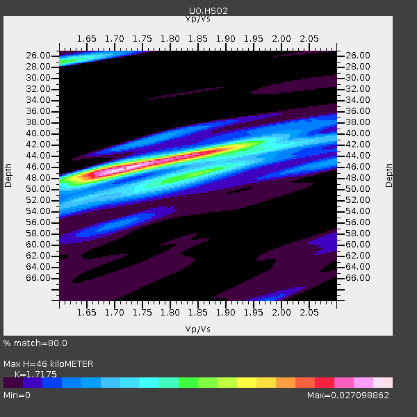
| Thickness Estimate: | 47 km |
| Thickness StdDev: | 1.4 km |
| Vp/Vs Estimate: | 1.69 |
| Vp/Vs StdDev: | 0.09 |
| Vs Estimate: | 3.859 km/s |
| Poisson's Ratio: | 0.23 |
| Peak Value: | 0.03 |
| Assumed Vp: | 6.522 km/s |
| Ps Weight: | 0.33333334 |
| PpPs Weight: | 0.33333334 |
| PsPs Weight: | 0.33333328 |
| Residual Complexity: | 0.594 |
| Nearby stations H: | +- |
| (2.0 deg) Vp/Vs: | +- |
7 with match > 90% ( 9.210526 %) and 19 with match > 80% ( 25.0 %) out of 76.
Download stack as xyz text file.
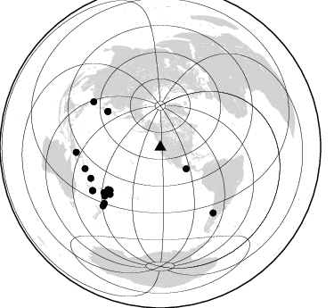
Azimuth Distribution of Events:
Prior Results for this Station
| Study | Thickness | Vp/Vs | Vp | Vs | Poissons Ratio | Extra |
| EARS | 47 km | 1.69 | 6.522 km/s | 3.859 km/s | 0.23 | |
| Crust2.0 | 37 km | 1.77 | 6.522 km/s | 3.676 km/s | 0.27 | LC,continental arc, Cordilleras, 1.0 km seds. |
| Global Maxima | 47 km | 1.69 | 6.522 km/s | 3.859 km/s | 0.23 | amp=0.027168285 |
| Local Maxima 1 | 43 km | 1.87 | 6.522 km/s | 3.483 km/s | 0.30 | amp=0.0146004325 |
| Local Maxima 2 | 46 km | 1.88 | 6.522 km/s | 3.464 km/s | 0.30 | amp=0.011664169 |
| Local Maxima 3 | 27 km | 1.60 | 6.522 km/s | 4.076 km/s | 0.18 | amp=0.010752061 |
| Local Maxima 4 | 45 km | 2.10 | 6.522 km/s | 3.109 km/s | 0.35 | amp=0.0064021987 |
| Predicted Arrivals for vertical incidence (zero ray parameter) | |
| Ps | 4.95 SECOND |
| PpPs | 19.28 SECOND |
| PsPs/PpSs | 24.23 SECOND |
Events Processed for this Station
Download zip of receiver functions as SAC
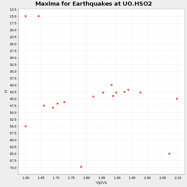
Plot maxima for each earthquake.
Events Used in the Stack
(19 events)| Radial Match | Distance | Baz | FERegion | Time | Lat/Lon | Depth | Magnitude |
| 95.03647 | 75.3 deg | 231.215 deg | Tonga Islands | 2023/05/10 16:02:00 UTC | (-15.6, -174.6) | 210 km | 7.6 mww |
| 94.32018 | 71.4 deg | 304.202 deg | Near West Coast Of Honshu, Japan | 2024/01/01 07:10:10 UTC | (37.5, 137.2) | 0.0 km | 7.4 Mi |
| 93.183136 | 74.3 deg | 230.005 deg | Samoa Islands Region | 2022/12/04 19:24:15 UTC | (-15.4, -173.0) | 36 km | 6.7 Mww |
| 92.95973 | 74.2 deg | 229.443 deg | Samoa Islands Region | 2022/12/04 19:24:27 UTC | (-15.7, -172.5) | 148 km | 6.9 Mi |
| 92.88828 | 77.0 deg | 227.007 deg | Tonga Islands Region | 2022/11/11 10:48:45 UTC | (-19.3, -172.1) | 25 km | 7.3 Mww |
| 90.81811 | 73.9 deg | 131.223 deg | Near Coast Of Peru | 2024/06/28 05:36:37 UTC | (-15.8, -74.4) | 28 km | 7.2 mww |
| 90.4784 | 89.9 deg | 237.368 deg | Southeast Of Loyalty Islands | 2023/05/19 02:57:07 UTC | (-23.2, 170.7) | 10 km | 7.7 Mi |
| 89.91229 | 87.6 deg | 254.217 deg | Solomon Islands | 2022/11/22 02:03:07 UTC | (-9.8, 159.6) | 14 km | 7.0 Mww |
| 89.36509 | 90.0 deg | 237.603 deg | Southeast Of Loyalty Islands | 2023/05/20 01:51:01 UTC | (-23.1, 170.4) | 45 km | 7.4 Mi |
| 88.779274 | 91.6 deg | 224.486 deg | South Of Kermadec Islands | 2023/09/08 09:09:58 UTC | (-32.7, -179.3) | 90 km | 6.6 mww |
| 87.87162 | 37.8 deg | 129.655 deg | Near Coast Of Chiapas, Mexico | 2023/07/14 09:29:01 UTC | (15.0, -93.9) | 35 km | 6.3 mww |
| 84.99419 | 71.3 deg | 304.177 deg | Near West Coast Of Honshu, Japan | 2023/05/05 05:42:04 UTC | (37.5, 137.3) | 8.7 km | 6.2 mww |
| 84.79154 | 88.7 deg | 225.134 deg | Kermadec Islands, New Zealand | 2023/04/24 00:41:54 UTC | (-30.0, -177.9) | 34 km | 7.3 mww |
| 83.37253 | 82.7 deg | 228.813 deg | South Of Fiji Islands | 2023/06/15 18:06:27 UTC | (-23.0, -177.2) | 167 km | 7.2 Mww |
| 83.16273 | 94.3 deg | 141.032 deg | Southern Argentina | 2023/07/17 03:05:10 UTC | (-38.2, -70.4) | 171 km | 6.6 mww |
| 82.54693 | 85.3 deg | 246.073 deg | Vanuatu Islands | 2023/08/16 12:47:40 UTC | (-13.9, 167.2) | 193 km | 6.5 Mww |
| 81.641815 | 90.5 deg | 304.126 deg | Taiwan | 2024/04/02 23:58:11 UTC | (23.8, 121.6) | 35 km | 7.4 mww |
| 81.35142 | 81.1 deg | 231.41 deg | Fiji Islands Region | 2022/11/12 07:09:14 UTC | (-20.1, -178.4) | 587 km | 7.0 mww |
| 81.15393 | 94.4 deg | 266.468 deg | Eastern New Guinea Reg., P.N.G. | 2023/10/07 08:34:26 UTC | (-5.6, 146.1) | 53 km | 6.7 mww |
Losers
(57 events)| Radial Match | Distance | Baz | FERegion | Time | Lat/Lon | Depth | Magnitude | Reason |
| 95.22616 | 82.6 deg | 227.246 deg | Tonga Islands Region | 2023/06/18 15:04:49 UTC | (-23.8, -175.7) | 10 km | 5.8 Mww | |
| 91.93142 | 87.3 deg | 137.28 deg | Near Coast Of Central Chile | 2023/09/06 23:48:05 UTC | (-30.3, -71.5) | 41 km | 6.2 mww | |
| 91.351494 | 84.7 deg | 51.517 deg | Morocco | 2023/09/08 22:11:01 UTC | (31.1, -8.4) | 19 km | 6.8 mww | |
| 89.34077 | 86.0 deg | 136.433 deg | Near Coast Of Central Chile | 2023/10/31 12:33:44 UTC | (-28.7, -71.6) | 41 km | 6.7 mww | |
| 85.026054 | 78.5 deg | 229.164 deg | Tonga Islands | 2024/05/26 20:47:09 UTC | (-19.4, -174.9) | 112 km | 6.6 mww | |
| 84.7827 | 87.9 deg | 223.576 deg | Kermadec Islands Region | 2023/03/16 00:55:58 UTC | (-30.2, -175.9) | 10 km | 7.1 Mi | |
| 83.16923 | 74.0 deg | 230.268 deg | Tonga Islands | 2023/08/08 18:38:56 UTC | (-15.0, -173.0) | 120 km | 6.2 Mi | |
| 81.06222 | 80.6 deg | 236.916 deg | Fiji Islands | 2023/03/11 13:29:46 UTC | (-16.4, 177.5) | 10 km | 5.5 mww | |
| 79.950836 | 60.3 deg | 127.971 deg | Near Coast Of Ecuador | 2023/03/18 17:12:53 UTC | (-2.9, -79.8) | 66 km | 6.7 Mww | |
| 79.71823 | 39.5 deg | 125.814 deg | Guatemala | 2023/05/17 23:02:00 UTC | (15.1, -90.9) | 256 km | 6.4 mww | |
| 79.0815 | 50.6 deg | 309.691 deg | Near East Coast Of Kamchatka | 2023/04/03 03:06:55 UTC | (52.8, 158.6) | 100 km | 6.7 Mi | |
| 77.57881 | 77.2 deg | 303.633 deg | Shikoku, Japan | 2024/04/17 14:14:45 UTC | (33.2, 132.4) | 26 km | 6.3 mww | |
| 77.51707 | 36.3 deg | 303.51 deg | Andreanof Islands, Aleutian Is. | 2023/10/16 11:35:31 UTC | (52.4, -176.9) | 187 km | 6.4 Mww | |
| 77.304054 | 78.2 deg | 285.023 deg | Mariana Islands | 2024/04/05 11:03:16 UTC | (19.1, 145.4) | 222 km | 6.8 mww | |
| 76.19819 | 41.2 deg | 118.739 deg | North Of Honduras | 2023/02/08 15:16:17 UTC | (16.8, -86.1) | 10 km | 5.5 mww | |
| 75.44562 | 81.2 deg | 131.41 deg | Near Coast Of Northern Chile | 2023/12/21 16:21:52 UTC | (-21.9, -70.1) | 63 km | 5.6 mww | |
| 74.1889 | 67.0 deg | 303.983 deg | Near East Coast Of Honshu, Japan | 2024/04/01 19:24:36 UTC | (40.1, 141.7) | 73 km | 5.9 mww | |
| 72.77044 | 96.7 deg | 16.05 deg | Turkey | 2023/02/06 12:02:11 UTC | (38.1, 36.5) | 10 km | 6.0 mb | |
| 72.2091 | 88.4 deg | 261.964 deg | New Ireland Region, P.N.G. | 2022/10/13 22:20:20 UTC | (-4.8, 153.6) | 71 km | 6.4 mww | |
| 71.29701 | 95.6 deg | 269.391 deg | New Guinea, Papua New Guinea | 2023/04/02 18:04:12 UTC | (-4.3, 143.2) | 74 km | 7.3 Mi | |
| 71.26038 | 87.8 deg | 242.889 deg | Vanuatu Islands | 2024/01/23 14:33:47 UTC | (-17.9, 167.8) | 10 km | 6.5 Mi | |
| 71.193 | 39.1 deg | 128.288 deg | Near Coast Of Chiapas, Mexico | 2024/05/12 11:39:14 UTC | (14.5, -92.4) | 75 km | 6.4 mww | |
| 71.16263 | 82.3 deg | 226.816 deg | Tonga Islands Region | 2023/06/16 19:10:52 UTC | (-23.8, -175.2) | 10 km | 6.5 Mi | |
| 69.45987 | 50.4 deg | 122.833 deg | South Of Panama | 2022/10/20 11:57:14 UTC | (7.7, -82.3) | 10 km | 6.9 Mi | |
| 68.60548 | 84.5 deg | 129.642 deg | Jujuy Province, Argentina | 2023/03/22 16:00:31 UTC | (-23.5, -66.5) | 210 km | 6.5 mww | |
| 67.88721 | 37.0 deg | 128.167 deg | Chiapas, Mexico | 2023/08/09 09:33:26 UTC | (16.2, -93.6) | 111 km | 5.8 mww | |
| 67.39387 | 79.4 deg | 233.489 deg | Fiji Islands Region | 2023/10/31 11:10:56 UTC | (-17.5, -179.0) | 548 km | 6.4 mww | |
| 67.10445 | 41.3 deg | 128.032 deg | Off Coast Of Central America | 2023/07/30 01:10:29 UTC | (12.7, -90.9) | 10 km | 5.7 Mww | |
| 66.74433 | 52.7 deg | 307.991 deg | Kuril Islands | 2023/09/01 20:49:54 UTC | (50.7, 156.3) | 141 km | 6.1 Mww | |
| 65.62222 | 88.8 deg | 226.083 deg | Kermadec Islands, New Zealand | 2023/03/04 06:41:22 UTC | (-29.5, -178.8) | 206 km | 6.9 mww | |
| 64.63402 | 86.7 deg | 252.598 deg | Solomon Islands | 2023/05/21 15:45:13 UTC | (-10.3, 161.4) | 78 km | 6.1 Mww | |
| 63.1682 | 50.5 deg | 122.954 deg | South Of Panama | 2023/04/04 22:18:12 UTC | (7.6, -82.3) | 10 km | 6.3 mww | |
| 62.06759 | 39.2 deg | 302.956 deg | Rat Islands, Aleutian Islands | 2022/12/14 18:40:26 UTC | (51.6, 178.6) | 73 km | 6.3 Mww | |
| 61.826756 | 89.0 deg | 129.173 deg | Santiago Del Estero Prov., Arg. | 2023/01/20 22:09:39 UTC | (-26.7, -63.0) | 611 km | 6.8 mww | |
| 61.654648 | 46.1 deg | 312.198 deg | Komandorskiye Ostrova Region | 2023/10/26 16:05:11 UTC | (56.1, 164.7) | 2.4 km | 5.9 Mww | |
| 60.747246 | 94.2 deg | 301.389 deg | Philippine Islands Region | 2023/09/12 11:03:18 UTC | (19.3, 121.2) | 41 km | 6.3 Mww | |
| 60.5313 | 36.6 deg | 238.409 deg | Hawaii | 2024/02/09 20:06:30 UTC | (19.0, -155.5) | 10 km | 6.3 Mi | |
| 60.512592 | 58.1 deg | 97.886 deg | Leeward Islands | 2023/01/20 11:23:40 UTC | (16.2, -62.0) | 165 km | 5.8 Mi | |
| 60.4901 | 84.0 deg | 281.274 deg | South Of Mariana Islands | 2024/02/04 09:50:42 UTC | (12.4, 143.5) | 10 km | 5.7 Mi | |
| 58.947544 | 79.4 deg | 283.475 deg | Mariana Islands | 2023/07/25 10:35:18 UTC | (17.1, 145.5) | 373 km | 5.6 mww | |
| 56.427402 | 96.3 deg | 177.064 deg | Southern East Pacific Rise | 2023/05/03 23:25:46 UTC | (-53.0, -118.3) | 10 km | 5.4 Mww | |
| 55.603806 | 87.2 deg | 243.366 deg | Vanuatu Islands | 2024/05/25 22:23:16 UTC | (-17.1, 167.9) | 29 km | 6.3 mww | |
| 55.527283 | 88.9 deg | 129.237 deg | Santiago Del Estero Prov., Arg. | 2023/01/24 18:37:00 UTC | (-26.7, -63.1) | 596 km | 6.4 mww | |
| 55.517498 | 87.5 deg | 230.219 deg | South Of Fiji Islands | 2022/11/09 09:38:42 UTC | (-26.0, 178.4) | 629 km | 6.8 mww | |
| 54.904736 | 79.3 deg | 167.163 deg | Southern East Pacific Rise | 2023/07/10 21:34:52 UTC | (-34.9, -107.7) | 10 km | 5.7 Mww | |
| 54.654472 | 66.4 deg | 302.68 deg | Off East Coast Of Honshu, Japan | 2023/08/24 22:48:26 UTC | (39.6, 143.3) | 35 km | 5.8 Mww | |
| 54.3524 | 76.3 deg | 295.299 deg | Bonin Islands, Japan Region | 2024/04/27 08:35:34 UTC | (27.8, 139.6) | 503 km | 6.5 mww | |
| 54.151188 | 70.2 deg | 309.546 deg | Primor'ye, Russia | 2023/06/27 23:38:21 UTC | (42.1, 134.1) | 443 km | 5.8 Mww | |
| 53.09119 | 78.4 deg | 284.889 deg | Mariana Islands | 2023/11/19 04:01:36 UTC | (18.8, 145.3) | 598 km | 5.9 mww | |
| 52.80716 | 82.3 deg | 130.719 deg | Northern Chile | 2022/11/02 02:37:59 UTC | (-22.3, -68.9) | 109 km | 5.3 Mww | |
| 51.798767 | 86.9 deg | 230.738 deg | South Of Fiji Islands | 2023/04/28 03:34:10 UTC | (-25.1, 178.4) | 570 km | 5.5 Mww | |
| 49.145416 | 80.2 deg | 301.338 deg | Southeast Of Ryukyu Islands | 2024/04/15 22:38:57 UTC | (29.5, 131.7) | 8.0 km | 5.9 mww | |
| 48.312683 | 86.2 deg | 244.527 deg | Vanuatu Islands | 2023/09/28 14:40:26 UTC | (-15.6, 167.7) | 126 km | 6.0 mww | |
| 46.76459 | 82.8 deg | 159.872 deg | Southeast Of Easter Island | 2023/09/14 22:51:26 UTC | (-36.5, -98.0) | 10 km | 5.6 mww | |
| 45.78557 | 74.7 deg | 296.655 deg | Southeast Of Honshu, Japan | 2023/10/03 11:38:04 UTC | (29.9, 140.0) | 12 km | 6.1 Mww | |
| 45.464188 | 86.3 deg | 236.516 deg | Vanuatu Islands Region | 2023/11/27 03:31:16 UTC | (-21.0, 173.9) | 10 km | 5.5 Mww | |
| 44.01583 | 86.8 deg | 230.701 deg | South Of Fiji Islands | 2023/04/28 03:51:06 UTC | (-25.1, 178.5) | 572 km | 5.5 mb |

