
Station UO PISTL - Pistol River, OR, USA
Network: UO - University of Oregon Regional Network
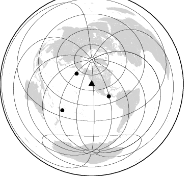
Nearby stations (2 deg radius)
| Station | Name | (Lat, Lon) | Start / End | Elevation |
| PISTL | Pistol River, OR, USA | (42.31, -124.35) | 2023-07-18 / 2499-01-01 | 648 m |
| Crust2 Type: | S2,continental slope, margin, transition 2 km seds. |
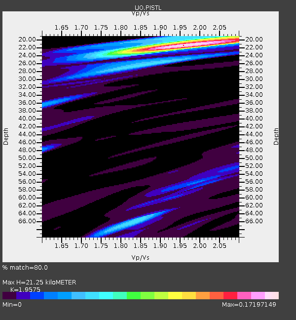
| Thickness Estimate: | 21 km |
| Thickness StdDev: | 0.6 km |
| Vp/Vs Estimate: | 1.99 |
| Vp/Vs StdDev: | 0.06 |
| Vs Estimate: | 3.043 km/s |
| Poisson's Ratio: | 0.33 |
| Peak Value: | 0.15 |
| Assumed Vp: | 6.048 km/s |
| Ps Weight: | 0.33333334 |
| PpPs Weight: | 0.33333334 |
| PsPs Weight: | 0.33333328 |
| Residual Complexity: | 0.388 |
| Nearby stations H: | +- |
| (2.0 deg) Vp/Vs: | +- |
0 with match > 90% ( 0.0 %) and 3 with match > 80% ( 8.333333 %) out of 36.
Download stack as xyz text file.
Azimuth Distribution of Events:
Prior Results for this Station
| Study | Thickness | Vp/Vs | Vp | Vs | Poissons Ratio | Extra |
| EARS | 21 km | 1.99 | 6.048 km/s | 3.043 km/s | 0.33 | |
| Crust2.0 | 24 km | 1.81 | 6.048 km/s | 3.34 km/s | 0.28 | S2,continental slope, margin, transition 2 km seds. |
| Global Maxima | 21 km | 1.99 | 6.048 km/s | 3.043 km/s | 0.33 | amp=0.15144217 |
| Local Maxima 1 | 19 km | 2.08 | 6.048 km/s | 2.915 km/s | 0.35 | amp=0.059570067 |
| Local Maxima 2 | 26 km | 1.88 | 6.048 km/s | 3.213 km/s | 0.30 | amp=0.04672278 |
| Local Maxima 3 | 56 km | 1.97 | 6.048 km/s | 3.066 km/s | 0.33 | amp=0.024661072 |
| Local Maxima 4 | 66 km | 1.98 | 6.048 km/s | 3.055 km/s | 0.33 | amp=0.023420027 |
| Predicted Arrivals for vertical incidence (zero ray parameter) | |
| Ps | 3.43 SECOND |
| PpPs | 10.37 SECOND |
| PsPs/PpSs | 13.80 SECOND |
Events Processed for this Station
Download zip of receiver functions as SAC
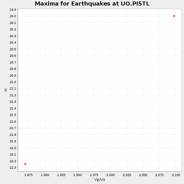
Plot maxima for each earthquake.
Events Used in the Stack
(3 events)| Radial Match | Distance | Baz | FERegion | Time | Lat/Lon | Depth | Magnitude |
| 85.53549 | 77.1 deg | 228.389 deg | Tonga Islands | 2024/05/26 20:47:09 UTC | (-19.4, -174.9) | 112 km | 6.6 mww |
| 81.40073 | 41.3 deg | 125.467 deg | Off Coast Of Central America | 2023/07/30 01:10:29 UTC | (12.7, -90.9) | 10 km | 5.7 Mww |
| 80.14897 | 36.2 deg | 304.731 deg | Andreanof Islands, Aleutian Is. | 2023/10/16 11:35:31 UTC | (52.4, -176.9) | 187 km | 6.4 Mww |
Losers
(33 events)| Radial Match | Distance | Baz | FERegion | Time | Lat/Lon | Depth | Magnitude | Reason |
| 97.88073 | 93.4 deg | 265.754 deg | Eastern New Guinea Reg., P.N.G. | 2023/10/07 09:18:50 UTC | (-5.5, 146.0) | 69 km | 5.6 mb | |
| 92.06998 | 90.3 deg | 303.343 deg | Taiwan | 2024/04/03 00:43:55 UTC | (24.0, 121.6) | 10 km | 5.5 mb | |
| 80.582016 | 96.1 deg | 15.076 deg | Turkey | 2024/04/18 15:11:25 UTC | (40.0, 36.0) | 10 km | 5.6 Mww | |
| 75.50895 | 39.1 deg | 125.582 deg | Near Coast Of Chiapas, Mexico | 2024/05/12 11:39:14 UTC | (14.5, -92.4) | 75 km | 6.4 mww | |
| 73.62759 | 37.0 deg | 125.317 deg | Chiapas, Mexico | 2023/08/09 09:33:26 UTC | (16.2, -93.6) | 111 km | 5.8 mww | |
| 73.23156 | 72.5 deg | 229.528 deg | Tonga Islands | 2023/08/08 18:38:56 UTC | (-15.0, -173.0) | 120 km | 6.2 Mi | |
| 71.786476 | 87.1 deg | 136.364 deg | Near Coast Of Central Chile | 2023/09/06 23:48:05 UTC | (-30.3, -71.5) | 41 km | 6.2 mww | |
| 71.53937 | 84.8 deg | 134.265 deg | Near Coast Of Northern Chile | 2023/09/11 13:37:08 UTC | (-27.2, -71.2) | 21 km | 5.5 Mww | |
| 71.25039 | 90.1 deg | 223.641 deg | South Of Kermadec Islands | 2023/09/08 09:09:58 UTC | (-32.7, -179.3) | 90 km | 6.6 mww | |
| 69.82641 | 51.9 deg | 122.734 deg | South Of Panama | 2023/08/03 01:25:21 UTC | (5.6, -82.6) | 8.0 km | 5.9 mww | |
| 69.53248 | 77.2 deg | 303.134 deg | Shikoku, Japan | 2024/04/17 14:14:45 UTC | (33.2, 132.4) | 26 km | 6.3 mww | |
| 68.01669 | 50.8 deg | 308.963 deg | Near East Coast Of Kamchatka | 2023/12/23 17:48:03 UTC | (52.0, 159.0) | 29 km | 5.8 Mww | |
| 66.06308 | 84.0 deg | 245.298 deg | Vanuatu Islands | 2023/08/16 12:47:40 UTC | (-13.9, 167.2) | 193 km | 6.5 Mww | |
| 65.60765 | 52.8 deg | 308.301 deg | Kuril Islands | 2023/09/01 20:49:54 UTC | (50.7, 156.3) | 141 km | 6.1 Mww | |
| 65.50998 | 89.9 deg | 262.12 deg | New Britain Region, P.N.G. | 2024/05/01 23:45:25 UTC | (-5.8, 151.0) | 29 km | 5.9 Mww | |
| 65.2458 | 43.6 deg | 122.242 deg | Near Coast Of Nicaragua | 2024/03/17 00:44:03 UTC | (12.4, -87.7) | 53 km | 5.6 mww | |
| 64.61347 | 81.3 deg | 230.385 deg | Fiji Islands Region | 2023/08/02 01:32:35 UTC | (-21.6, -179.3) | 632 km | 5.8 mww | |
| 64.47474 | 72.4 deg | 295.935 deg | Southeast Of Honshu, Japan | 2023/09/19 06:22:36 UTC | (31.0, 142.0) | 10 km | 5.8 mww | |
| 63.2582 | 86.9 deg | 240.374 deg | Vanuatu Islands | 2023/10/29 04:32:08 UTC | (-19.4, 168.8) | 80 km | 6.0 mww | |
| 62.403675 | 51.4 deg | 115.181 deg | Panama | 2023/08/29 04:59:19 UTC | (9.9, -78.4) | 10 km | 5.5 mww | |
| 62.056202 | 35.5 deg | 126.097 deg | Chiapas, Mexico | 2023/10/07 05:06:55 UTC | (17.1, -95.0) | 108 km | 5.9 mww | |
| 60.15177 | 77.6 deg | 284.482 deg | Mariana Islands | 2024/04/05 11:03:16 UTC | (19.1, 145.4) | 222 km | 6.8 mww | |
| 57.26231 | 80.1 deg | 300.757 deg | Southeast Of Ryukyu Islands | 2024/04/15 22:38:57 UTC | (29.5, 131.7) | 8.0 km | 5.9 mww | |
| 55.44982 | 67.0 deg | 303.783 deg | Near East Coast Of Honshu, Japan | 2024/04/01 19:24:36 UTC | (40.1, 141.7) | 73 km | 5.9 mww | |
| 53.68975 | 38.4 deg | 304.336 deg | Rat Islands, Aleutian Islands | 2024/02/28 15:50:21 UTC | (51.9, 179.6) | 119 km | 5.5 mww | |
| 52.60515 | 93.4 deg | 265.548 deg | Eastern New Guinea Reg., P.N.G. | 2023/10/07 08:34:26 UTC | (-5.6, 146.1) | 53 km | 6.7 mww | |
| 51.904327 | 40.5 deg | 123.743 deg | Guatemala | 2024/01/27 05:52:49 UTC | (14.1, -90.5) | 108 km | 6.1 Mww | |
| 50.60773 | 87.6 deg | 239.229 deg | Vanuatu Islands | 2023/12/07 12:56:30 UTC | (-20.7, 169.2) | 48 km | 7.1 Mww | |
| 45.87724 | 90.1 deg | 303.446 deg | Taiwan | 2024/04/26 18:49:29 UTC | (24.2, 121.7) | 39 km | 5.2 Mww | |
| 40.884537 | 78.0 deg | 232.731 deg | Fiji Islands Region | 2023/10/31 11:10:56 UTC | (-17.5, -179.0) | 548 km | 6.4 mww | |
| 40.427433 | 69.7 deg | 122.577 deg | Western Brazil | 2024/01/28 09:38:56 UTC | (-8.2, -71.4) | 609 km | 6.5 Mww | |
| 38.485615 | 68.9 deg | 301.311 deg | Near East Coast Of Honshu, Japan | 2024/03/16 21:17:04 UTC | (37.1, 141.5) | 45 km | 5.3 Mww | |
| 35.59024 | 97.7 deg | 289.228 deg | Mindanao, Philippines | 2023/12/03 10:58:38 UTC | (8.8, 126.9) | 44 km | 5.5 mb |

