
Station US HRV - Harvard--Oak Ridge, Massachusetts, USA
Network: US - United States National Seismic Network
Nearby stations (2 deg radius)
| Station | Name | (Lat, Lon) | Start / End | Elevation |
| HRV | Harvard--Oak Ridge, Massachusetts, USA | (42.51, -71.56) | 1992-02-04 / 2499-01-01 | 180 m |
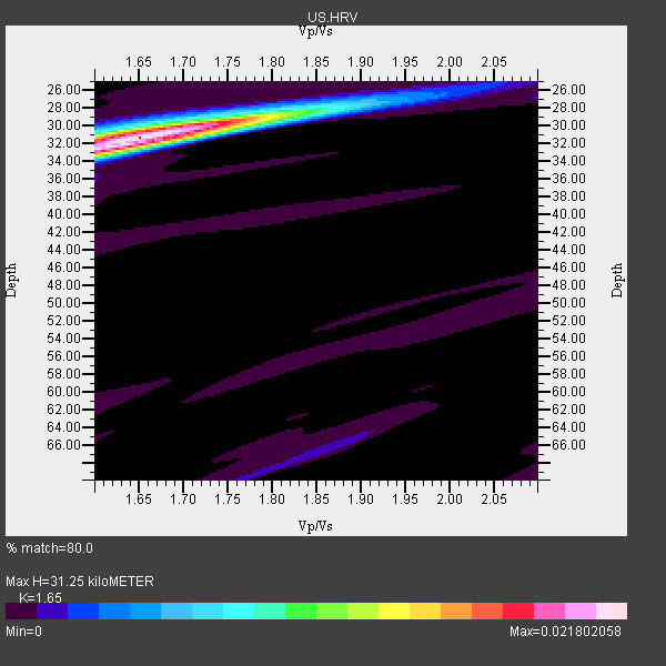
| Crust2 Type: | Q2,orogen/39km no ice, Appalachians, North Andes, 0.5 km seds. |
| Thickness Estimate: | 31 km |
| Thickness StdDev: | 2.5 km |
| Vp/Vs Estimate: | 1.65 |
| Vp/Vs StdDev: | 0.04 |
| Vs Estimate: | 3.89 km/s |
| Poisson's Ratio: | 0.21 |
| Peak Value: | 0.02 |
| Assumed Vp: | 6.419 km/s |
| Ps Weight: | 0.33333334 |
| PpPs Weight: | 0.33333334 |
| PsPs Weight: | 0.33333328 |
| Residual Complexity: | 0.270 |
| Nearby stations H: | 31 km +- 0.0 km |
| (2.0 deg) Vp/Vs: | 1.66 +- 0.02 |
10 with match > 90% ( 71.42857 %) and 14 with match > 80% ( 100.0 %) out of 14.
Download stack as xyz text file.
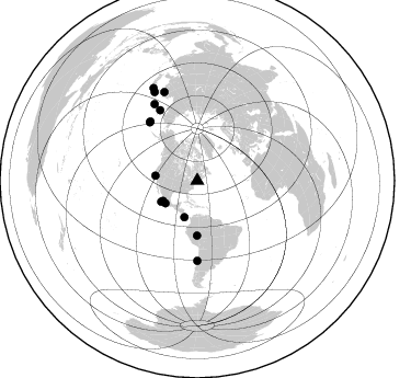
Azimuth Distribution of Events:
Prior Results for this Station
| Study | Thickness | Vp/Vs | Vp | Vs | Poissons Ratio | Extra |
| EARS | 31 km | 1.65 | 6.419 km/s | 3.89 km/s | 0.21 | |
| Crust2.0 | 39 km | 1.75 | 6.419 km/s | 3.659 km/s | 0.26 | Q2,orogen/39km no ice, Appalachians, North Andes, 0.5 km seds. |
| MOMA | 29 km | 1.80 | 6.6 km/s | 3.667 km/s | 0.28 | |
| MOMA | 30 km | 1.73 | 6.5 km/s | 3.757 km/s | 0.25 | |
| Zandt Ammon | 28 km | 1.73 | 6.0 km/s | 3.468 km/s | 0.25 | |
| Zandt Ammon | 29 km | 1.73 | 6.25 km/s | 3.613 km/s | 0.25 | |
| Zandt Ammon | 30 km | 1.72 | 6.5 km/s | 3.779 km/s | 0.24 | |
| Zandt Ammon | 31 km | 1.71 | 6.75 km/s | 3.947 km/s | 0.24 | |
| Global Maxima | 31 km | 1.65 | 6.419 km/s | 3.89 km/s | 0.21 | amp=0.021802058 |
| Local Maxima 1 | 29 km | 1.78 | 6.419 km/s | 3.601 km/s | 0.27 | amp=0.0076137967 |
| Local Maxima 2 | 33 km | 1.60 | 6.419 km/s | 4.012 km/s | 0.18 | amp=0.005865824 |
| Local Maxima 3 | 31 km | 1.62 | 6.419 km/s | 3.969 km/s | 0.19 | amp=0.0040961443 |
| Local Maxima 4 | 66 km | 1.87 | 6.419 km/s | 3.437 km/s | 0.30 | amp=0.0017101864 |
| Predicted Arrivals for vertical incidence (zero ray parameter) | |
| Ps | 3.16 SECOND |
| PpPs | 12.90 SECOND |
| PsPs/PpSs | 16.07 SECOND |
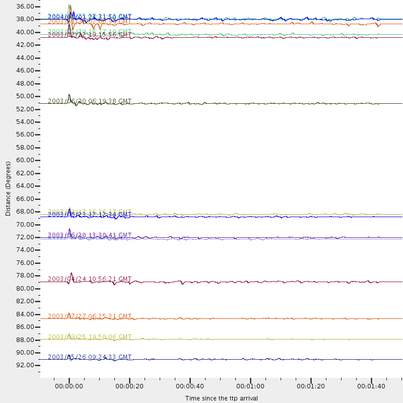
Events Processed for this Station
Download zip of receiver functions as SAC
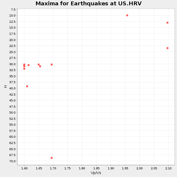
Plot maxima for each earthquake.
Events Used in the Stack
(14 events)| Radial Match | Distance | Baz | FERegion | Time | Lat/Lon | Depth | Magnitude |
| 98.45809 | 72.8 deg | 180.071 deg | Near Coast Of Central Chile | 2003/06/20 13:30:41 GMT | (-30.6, -71.6) | 33 km | 6.4 MB, 6.8 MS, 6.8 MW, 6.7 MW |
| 98.40827 | 90.2 deg | 334.294 deg | Hokkaido, Japan Region | 2003/09/25 19:50:06 GMT | (41.8, 143.9) | 27 km | 6.9 MB, 8.1 MS, 8.3 MW, 8.1 MW |
| 96.72588 | 49.9 deg | 180.212 deg | Western Brazil | 2003/06/20 06:19:38 GMT | (-7.6, -71.7) | 558 km | 6.4 MB, 7.1 MW, 7.0 MW |
| 95.28108 | 69.3 deg | 321.534 deg | Rat Islands, Aleutian Islands | 2003/06/23 12:12:34 GMT | (51.4, 176.8) | 20 km | 6.3 MB, 7.0 MS, 6.9 MW, 6.8 MW |
| 95.15178 | 86.6 deg | 339.504 deg | Primor'ye, Russia | 2003/07/27 06:25:31 GMT | (47.2, 139.2) | 470 km | 6.3 MB, 6.8 MW, 6.8 MW |
| 94.54837 | 73.0 deg | 332.223 deg | Kamchatka Peninsula, Russia | 2003/06/16 22:08:02 GMT | (55.5, 160.0) | 175 km | 6.3 MB, 6.9 MW, 6.9 MW |
| 92.15356 | 36.3 deg | 239.423 deg | Near Coast Of Jalisco, Mexico | 2003/01/22 02:06:34 GMT | (18.8, -104.1) | 24 km | 6.5 MB, 7.6 MS, 7.6 MW, 7.4 MW |
| 91.81069 | 35.5 deg | 234.562 deg | Near Coast Of Guerrero, Mexico | 2004/01/01 23:31:50 GMT | (17.5, -101.3) | 29 km | 5.6 MB, 5.7 MS, 6.0 MW, 6.0 MW |
| 90.71581 | 38.1 deg | 239.67 deg | Off Coast Of Jalisco, Mexico | 2003/05/19 16:27:10 GMT | (17.5, -105.5) | 10 km | 5.6 MB, 5.8 MS, 6.2 MW, 6.1 MW |
| 90.62238 | 38.6 deg | 276.827 deg | Central California | 2003/12/22 19:15:56 GMT | (35.7, -121.1) | 7.6 km | 6.1 MB, 6.4 MS, 6.5 MW, 6.4 MW |
| 87.878525 | 35.4 deg | 199.504 deg | Panama-Costa Rica Border Region | 2003/12/25 07:11:11 GMT | (8.4, -82.8) | 33 km | 6.0 MB, 6.4 MS, 6.5 MW, 6.5 MW |
| 85.2056 | 93.6 deg | 334.686 deg | Near East Coast Of Honshu, Japan | 2003/05/26 09:24:33 GMT | (38.8, 141.6) | 68 km | 6.7 MB, 7.0 MW, 7.0 MW |
| 81.90824 | 68.8 deg | 320.861 deg | Rat Islands, Aleutian Islands | 2003/03/17 16:36:17 GMT | (51.3, 178.0) | 33 km | 5.9 MB, 6.7 MS, 7.0 MW, 7.0 MW |
| 81.43692 | 80.3 deg | 330.837 deg | Kuril Islands | 2003/04/24 10:56:21 GMT | (48.8, 155.0) | 44 km | 5.6 MB, 5.7 MS, 6.1 MW, 6.0 MW |
Losers
(0 events)| Radial Match | Distance | Baz | FERegion | Time | Lat/Lon | Depth | Magnitude | Reason |
