
Station UW BURN - Burns, OR, USA
Network: UW - Pacific Northwest Regional Seismic Network
Nearby stations (2 deg radius)
| Station | Name | (Lat, Lon) | Start / End | Elevation |
| BURN | Burns, OR, USA | (43.57, -119.13) | 2004-06-29 / 2499-01-01 | 1616 m |
| Crust2 Type: | M7,medium thick extended crust, 0.5 km seds. |
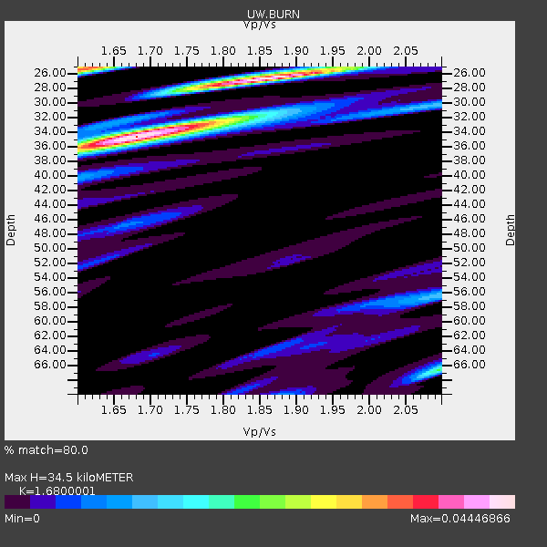
| Thickness Estimate: | 32 km |
| Thickness StdDev: | 3.5 km |
| Vp/Vs Estimate: | 1.81 |
| Vp/Vs StdDev: | 0.13 |
| Vs Estimate: | 3.469 km/s |
| Poisson's Ratio: | 0.28 |
| Peak Value: | 0.02 |
| Assumed Vp: | 6.279 km/s |
| Ps Weight: | 0.33333334 |
| PpPs Weight: | 0.33333334 |
| PsPs Weight: | 0.33333328 |
| Residual Complexity: | 0.614 |
| Nearby stations H: | +- |
| (2.0 deg) Vp/Vs: | +- |
3 with match > 90% ( 5.769231 %) and 11 with match > 80% ( 21.153847 %) out of 52.
Download stack as xyz text file.
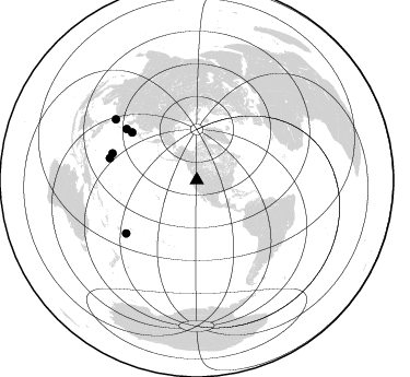
Azimuth Distribution of Events:
Prior Results for this Station
| Study | Thickness | Vp/Vs | Vp | Vs | Poissons Ratio | Extra |
| EARS | 32 km | 1.81 | 6.279 km/s | 3.469 km/s | 0.28 | |
| Crust2.0 | 35 km | 1.78 | 6.279 km/s | 3.533 km/s | 0.27 | M7,medium thick extended crust, 0.5 km seds. |
| Global Maxima | 32 km | 1.81 | 6.279 km/s | 3.469 km/s | 0.28 | amp=0.02384297 |
| Local Maxima 1 | 25 km | 2.10 | 6.279 km/s | 2.993 km/s | 0.35 | amp=0.014855385 |
| Local Maxima 2 | 43 km | 1.66 | 6.279 km/s | 3.777 km/s | 0.22 | amp=0.013469639 |
| Local Maxima 3 | 32 km | 1.94 | 6.279 km/s | 3.232 km/s | 0.32 | amp=0.013113485 |
| Local Maxima 4 | 25 km | 1.62 | 6.279 km/s | 3.87 km/s | 0.19 | amp=0.012992285 |
| Predicted Arrivals for vertical incidence (zero ray parameter) | |
| Ps | 4.16 SECOND |
| PpPs | 14.43 SECOND |
| PsPs/PpSs | 18.59 SECOND |
Events Processed for this Station
Download zip of receiver functions as SAC
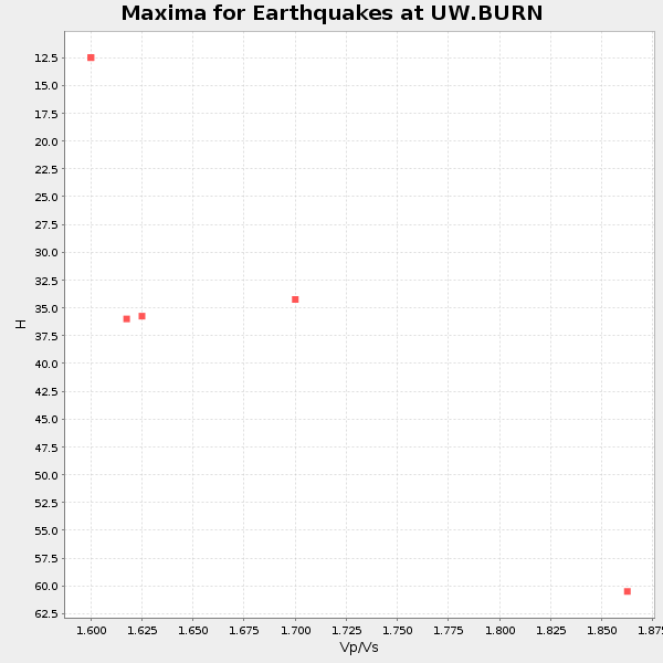
Plot maxima for each earthquake.
Events Used in the Stack
(11 events)| Radial Match | Distance | Baz | FERegion | Time | Lat/Lon | Depth | Magnitude |
| 95.07432 | 71.9 deg | 134.57 deg | Near Coast Of Peru | 2024/06/28 05:36:37 UTC | (-15.8, -74.4) | 28 km | 7.2 mww |
| 94.497154 | 73.8 deg | 306.396 deg | Near West Coast Of Honshu, Japan | 2024/01/01 07:10:10 UTC | (37.5, 137.2) | 0.0 km | 7.4 Mi |
| 90.05579 | 80.8 deg | 232.221 deg | Tonga Islands | 2024/05/26 20:47:09 UTC | (-19.4, -174.9) | 112 km | 6.6 mww |
| 87.19017 | 37.0 deg | 133.486 deg | Near Coast Of Chiapas, Mexico | 2024/05/12 11:39:14 UTC | (14.5, -92.4) | 75 km | 6.4 mww |
| 86.71187 | 82.1 deg | 284.202 deg | Mariana Islands | 2024/04/02 09:54:09 UTC | (15.8, 146.9) | 10 km | 6.2 mww |
| 86.67444 | 80.9 deg | 287.595 deg | Mariana Islands | 2024/04/05 11:03:16 UTC | (19.1, 145.4) | 222 km | 6.8 mww |
| 85.52957 | 92.9 deg | 306.908 deg | Taiwan | 2024/04/02 23:58:11 UTC | (23.8, 121.6) | 35 km | 7.4 mww |
| 82.48364 | 71.9 deg | 134.712 deg | Near Coast Of Peru | 2024/06/16 14:47:31 UTC | (-15.9, -74.5) | 20 km | 6.0 mww |
| 81.72457 | 35.1 deg | 302.695 deg | Fox Islands, Aleutian Islands | 2024/05/19 09:35:24 UTC | (52.2, -170.9) | 28 km | 6.0 mww |
| 80.96964 | 80.6 deg | 233.119 deg | Tonga Islands | 2023/12/11 06:33:31 UTC | (-18.7, -175.5) | 238 km | 6.1 Mww |
| 80.05263 | 79.6 deg | 306.016 deg | Shikoku, Japan | 2024/04/17 14:14:45 UTC | (33.2, 132.4) | 26 km | 6.3 mww |
Losers
(41 events)| Radial Match | Distance | Baz | FERegion | Time | Lat/Lon | Depth | Magnitude | Reason |
| 88.92932 | 92.5 deg | 306.987 deg | Taiwan | 2024/04/03 00:46:44 UTC | (24.1, 121.7) | 10 km | 5.7 mb | |
| 79.92651 | 78.0 deg | 233.169 deg | Tonga Islands | 2024/06/18 06:40:36 UTC | (-16.5, -173.8) | 35 km | 5.9 mww | |
| 75.37897 | 80.7 deg | 286.901 deg | Mariana Islands | 2023/12/10 14:11:39 UTC | (18.8, 146.1) | 119 km | 5.7 mww | |
| 72.6411 | 81.2 deg | 287.011 deg | Mariana Islands | 2024/01/20 15:48:41 UTC | (18.5, 145.6) | 195 km | 6.1 mww | |
| 72.141464 | 89.9 deg | 246.127 deg | Vanuatu Islands | 2024/05/25 22:23:16 UTC | (-17.1, 167.9) | 29 km | 6.3 mww | |
| 72.04946 | 60.8 deg | 75.398 deg | Northern Mid-Atlantic Ridge | 2024/03/14 21:10:25 UTC | (29.8, -42.7) | 10 km | 6.0 mww | |
| 71.68701 | 73.8 deg | 306.341 deg | Near West Coast Of Honshu, Japan | 2024/06/02 21:31:38 UTC | (37.5, 137.2) | 4.8 km | 5.8 mww | |
| 71.13009 | 88.3 deg | 247.535 deg | Vanuatu Islands | 2023/11/22 04:47:31 UTC | (-15.0, 168.0) | 13 km | 6.7 mww | |
| 70.12147 | 60.8 deg | 75.672 deg | Northern Mid-Atlantic Ridge | 2024/06/03 06:41:51 UTC | (29.6, -42.8) | 10 km | 5.9 mww | |
| 69.41894 | 81.8 deg | 235.787 deg | Fiji Islands Region | 2024/06/04 10:00:02 UTC | (-18.0, -178.4) | 586 km | 5.6 Mww | |
| 68.68505 | 83.9 deg | 230.751 deg | Tonga Islands Region | 2023/12/24 02:22:17 UTC | (-22.7, -175.7) | 49 km | 5.3 Mww | |
| 67.75975 | 86.7 deg | 250.027 deg | Santa Cruz Islands | 2024/05/21 09:50:43 UTC | (-12.1, 167.3) | 248 km | 5.4 Mww | |
| 67.05608 | 78.9 deg | 297.736 deg | Bonin Islands, Japan Region | 2024/04/27 08:35:34 UTC | (27.8, 139.6) | 503 km | 6.5 mww | |
| 67.002365 | 93.8 deg | 265.637 deg | New Britain Region, P.N.G. | 2024/04/14 20:56:28 UTC | (-5.8, 151.1) | 49 km | 6.5 mww | |
| 66.98148 | 79.2 deg | 134.487 deg | Near Coast Of Northern Chile | 2023/12/21 16:21:52 UTC | (-21.9, -70.1) | 63 km | 5.6 mww | |
| 66.75584 | 82.6 deg | 303.827 deg | Southeast Of Ryukyu Islands | 2024/04/15 22:38:57 UTC | (29.5, 131.7) | 8.0 km | 5.9 mww | |
| 66.6723 | 80.6 deg | 232.708 deg | Tonga Islands | 2024/01/18 22:12:20 UTC | (-18.9, -175.1) | 218 km | 6.4 Mww | |
| 65.92017 | 93.8 deg | 18.907 deg | Turkey | 2024/04/18 15:11:25 UTC | (40.0, 36.0) | 10 km | 5.6 Mww | |
| 64.398674 | 60.0 deg | 312.13 deg | Sea Of Okhotsk | 2024/06/06 11:07:53 UTC | (50.1, 147.6) | 622 km | 5.9 mww | |
| 63.84366 | 91.5 deg | 242.778 deg | Vanuatu Islands | 2023/12/07 12:56:30 UTC | (-20.7, 169.2) | 48 km | 7.1 Mww | |
| 60.713993 | 92.8 deg | 306.934 deg | Taiwan | 2024/04/22 18:32:48 UTC | (23.9, 121.6) | 10 km | 6.1 Mww | |
| 58.31288 | 73.7 deg | 306.379 deg | Near West Coast Of Honshu, Japan | 2024/01/01 07:06:05 UTC | (37.5, 137.2) | 10 km | 5.5 mww | |
| 58.272865 | 90.5 deg | 245.638 deg | Vanuatu Islands | 2024/01/23 14:33:47 UTC | (-17.9, 167.8) | 10 km | 6.5 Mi | |
| 58.196648 | 52.9 deg | 309.83 deg | Near East Coast Of Kamchatka | 2023/12/23 17:48:03 UTC | (52.0, 159.0) | 29 km | 5.8 Mww | |
| 57.6109 | 88.4 deg | 247.409 deg | Vanuatu Islands | 2024/05/08 08:17:15 UTC | (-15.1, 168.0) | 12 km | 6.1 mww | |
| 57.33016 | 90.5 deg | 228.846 deg | Kermadec Islands, New Zealand | 2024/05/17 20:58:27 UTC | (-29.1, -178.5) | 196 km | 5.8 Mww | |
| 57.113453 | 30.5 deg | 138.905 deg | Central Mexico | 2023/12/07 20:03:38 UTC | (18.4, -98.6) | 44 km | 5.8 mww | |
| 56.982708 | 66.5 deg | 126.948 deg | Western Brazil | 2024/01/20 21:31:07 UTC | (-7.3, -71.5) | 629 km | 6.5 Mww | |
| 56.97488 | 83.8 deg | 234.113 deg | Fiji Islands Region | 2024/03/02 00:26:40 UTC | (-20.6, -178.4) | 537 km | 5.8 mww | |
| 56.500797 | 80.0 deg | 233.388 deg | Tonga Islands | 2023/12/12 04:00:15 UTC | (-18.0, -175.3) | 261 km | 5.8 Mww | |
| 55.636307 | 77.5 deg | 132.103 deg | Northern Chile | 2023/12/02 07:55:40 UTC | (-19.2, -69.1) | 106 km | 5.8 Mww | |
| 54.86538 | 81.4 deg | 230.429 deg | Tonga Islands | 2023/12/24 14:52:55 UTC | (-20.9, -173.8) | 10 km | 5.4 Mww | |
| 53.786488 | 89.5 deg | 284.431 deg | W. Caroline Islands, Micronesia | 2024/05/05 05:44:19 UTC | (10.9, 141.2) | 10 km | 5.6 mb | |
| 49.13136 | 94.2 deg | 226.65 deg | South Of Kermadec Islands | 2024/06/27 16:37:51 UTC | (-33.4, -179.2) | 32 km | 5.9 Mww | |
| 48.146614 | 60.5 deg | 306.63 deg | Kuril Islands | 2023/11/10 10:10:04 UTC | (45.9, 151.0) | 107 km | 5.8 mww | |
| 47.589928 | 92.2 deg | 242.174 deg | Southeast Of Loyalty Islands | 2023/12/17 07:37:59 UTC | (-21.6, 169.2) | 10 km | 5.7 Mww | |
| 46.088303 | 96.3 deg | 179.497 deg | Southern East Pacific Rise | 2023/12/27 21:33:18 UTC | (-53.1, -118.3) | 10 km | 5.7 mww | |
| 44.29414 | 92.9 deg | 306.772 deg | Taiwan | 2024/04/22 18:26:52 UTC | (23.7, 121.7) | 9.0 km | 6.1 mww | |
| 40.760307 | 82.0 deg | 284.237 deg | Mariana Islands | 2024/04/02 22:16:44 UTC | (15.9, 146.9) | 10 km | 5.2 Mww | |
| 35.494328 | 93.8 deg | 265.691 deg | New Britain Region, P.N.G. | 2024/05/01 23:45:25 UTC | (-5.8, 151.0) | 29 km | 5.9 Mww | |
| 29.599302 | 77.1 deg | 302.279 deg | Southeast Of Honshu, Japan | 2024/05/29 17:14:58 UTC | (32.3, 137.6) | 392 km | 5.5 Mww |

