
Station UW GOLDN - Goldendale, WA, USA
Network: UW - Pacific Northwest Regional Seismic Network
Nearby stations (2 deg radius)
| Station | Name | (Lat, Lon) | Start / End | Elevation |
| GOLDN | Goldendale, WA, USA | (45.83, -120.85) | 2023-11-09 / 2499-01-01 | 512 m |
| Crust2 Type: | L3,continental arc, Southern Andes, 0.2 km seds. |
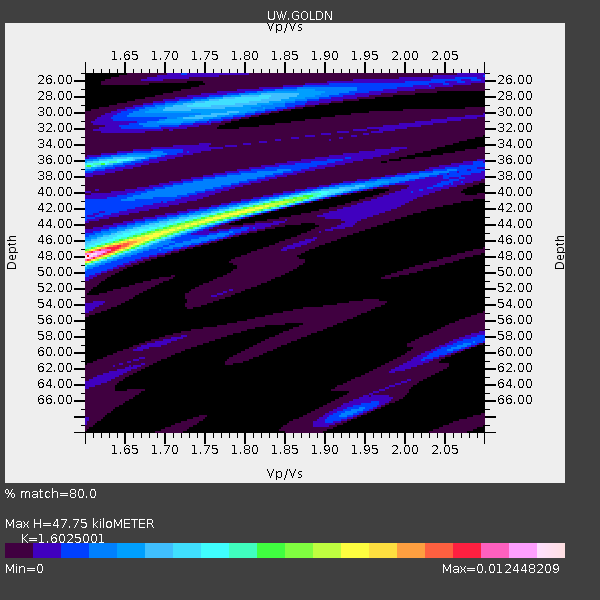
| Thickness Estimate: | 48 km |
| Thickness StdDev: | 6.9 km |
| Vp/Vs Estimate: | 1.60 |
| Vp/Vs StdDev: | 0.13 |
| Vs Estimate: | 4.117 km/s |
| Poisson's Ratio: | 0.18 |
| Peak Value: | 0.01 |
| Assumed Vp: | 6.597 km/s |
| Ps Weight: | 0.33333334 |
| PpPs Weight: | 0.33333334 |
| PsPs Weight: | 0.33333328 |
| Residual Complexity: | 0.726 |
| Nearby stations H: | +- |
| (2.0 deg) Vp/Vs: | +- |
3 with match > 90% ( 7.142857 %) and 7 with match > 80% ( 16.666666 %) out of 42.
Download stack as xyz text file.
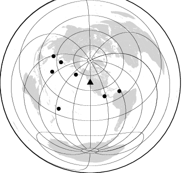
Azimuth Distribution of Events:
Prior Results for this Station
| Study | Thickness | Vp/Vs | Vp | Vs | Poissons Ratio | Extra |
| EARS | 48 km | 1.60 | 6.597 km/s | 4.117 km/s | 0.18 | |
| Crust2.0 | 40 km | 1.77 | 6.597 km/s | 3.723 km/s | 0.27 | L3,continental arc, Southern Andes, 0.2 km seds. |
| Global Maxima | 48 km | 1.60 | 6.597 km/s | 4.117 km/s | 0.18 | amp=0.012448209 |
| Local Maxima 1 | 42 km | 1.81 | 6.597 km/s | 3.655 km/s | 0.28 | amp=0.0071667302 |
| Local Maxima 2 | 36 km | 1.61 | 6.597 km/s | 4.111 km/s | 0.18 | amp=0.005806803 |
| Local Maxima 3 | 28 km | 1.77 | 6.597 km/s | 3.727 km/s | 0.27 | amp=0.0040111383 |
| Local Maxima 4 | 45 km | 1.69 | 6.597 km/s | 3.898 km/s | 0.23 | amp=0.0031016814 |
| Predicted Arrivals for vertical incidence (zero ray parameter) | |
| Ps | 4.36 SECOND |
| PpPs | 18.84 SECOND |
| PsPs/PpSs | 23.20 SECOND |
Events Processed for this Station
Download zip of receiver functions as SAC
Plot maxima for each earthquake.
Events Used in the Stack
(7 events)| Radial Match | Distance | Baz | FERegion | Time | Lat/Lon | Depth | Magnitude |
| 95.59219 | 81.3 deg | 230.62 deg | Tonga Islands | 2024/05/26 20:47:09 UTC | (-19.4, -174.9) | 112 km | 6.6 mww |
| 92.4366 | 71.4 deg | 304.841 deg | Near West Coast Of Honshu, Japan | 2024/01/01 07:10:10 UTC | (37.5, 137.2) | 0.0 km | 7.4 Mi |
| 90.70524 | 90.5 deg | 305.738 deg | Taiwan | 2024/04/02 23:58:11 UTC | (23.8, 121.6) | 35 km | 7.4 mww |
| 87.42371 | 32.9 deg | 299.56 deg | Fox Islands, Aleutian Islands | 2024/05/19 09:35:24 UTC | (52.2, -170.9) | 28 km | 6.0 mww |
| 86.041695 | 60.4 deg | 106.06 deg | Near Coast Of Venezuela | 2024/06/23 03:58:00 UTC | (10.8, -62.6) | 87 km | 6.0 mww |
| 86.03025 | 39.4 deg | 133.303 deg | Near Coast Of Chiapas, Mexico | 2024/05/12 11:39:14 UTC | (14.5, -92.4) | 75 km | 6.4 mww |
| 81.012856 | 79.1 deg | 286.074 deg | Mariana Islands | 2024/04/05 11:03:16 UTC | (19.1, 145.4) | 222 km | 6.8 mww |
Losers
(35 events)| Radial Match | Distance | Baz | FERegion | Time | Lat/Lon | Depth | Magnitude | Reason |
| 77.83061 | 61.4 deg | 75.572 deg | Northern Mid-Atlantic Ridge | 2024/03/14 21:10:25 UTC | (29.8, -42.7) | 10 km | 6.0 mww | |
| 77.82517 | 90.4 deg | 305.574 deg | Taiwan | 2024/04/03 01:39:34 UTC | (23.8, 121.8) | 14 km | 5.6 Mwr | |
| 76.18421 | 61.4 deg | 75.844 deg | Northern Mid-Atlantic Ridge | 2024/06/03 06:41:51 UTC | (29.6, -42.8) | 10 km | 5.9 mww | |
| 75.85544 | 77.3 deg | 304.581 deg | Shikoku, Japan | 2024/04/17 14:14:45 UTC | (33.2, 132.4) | 26 km | 6.3 mww | |
| 75.73056 | 78.4 deg | 232.356 deg | Tonga Islands | 2024/02/18 07:29:19 UTC | (-16.1, -174.6) | 212 km | 5.6 mww | |
| 75.600945 | 76.8 deg | 296.219 deg | Bonin Islands, Japan Region | 2024/04/27 08:35:34 UTC | (27.8, 139.6) | 503 km | 6.5 mww | |
| 74.52261 | 40.6 deg | 131.232 deg | Guatemala | 2024/01/27 05:52:49 UTC | (14.1, -90.5) | 108 km | 6.1 Mww | |
| 73.42423 | 39.1 deg | 238.545 deg | Hawaii | 2024/02/09 20:06:30 UTC | (19.0, -155.5) | 10 km | 6.3 Mi | |
| 72.5887 | 71.5 deg | 304.786 deg | Near West Coast Of Honshu, Japan | 2024/06/02 21:31:38 UTC | (37.5, 137.2) | 4.8 km | 5.8 mww | |
| 71.79003 | 74.3 deg | 133.743 deg | Near Coast Of Peru | 2024/06/16 14:47:31 UTC | (-15.9, -74.5) | 20 km | 6.0 mww | |
| 71.039116 | 89.7 deg | 244.914 deg | Vanuatu Islands | 2024/05/25 22:23:16 UTC | (-17.1, 167.9) | 29 km | 6.3 mww | |
| 70.34907 | 81.0 deg | 231.097 deg | Tonga Islands | 2024/01/18 22:12:20 UTC | (-18.9, -175.1) | 218 km | 6.4 Mww | |
| 70.34217 | 90.3 deg | 244.453 deg | Vanuatu Islands | 2024/01/23 14:33:47 UTC | (-17.9, 167.8) | 10 km | 6.5 Mi | |
| 69.62103 | 74.8 deg | 300.755 deg | Southeast Of Honshu, Japan | 2024/05/29 17:14:58 UTC | (32.3, 137.6) | 392 km | 5.5 Mww | |
| 66.611946 | 90.5 deg | 305.764 deg | Taiwan | 2024/04/22 18:32:48 UTC | (23.9, 121.6) | 10 km | 6.1 Mww | |
| 65.80007 | 78.4 deg | 231.436 deg | Tonga Islands | 2024/06/18 06:40:36 UTC | (-16.5, -173.8) | 35 km | 5.9 mww | |
| 65.15015 | 67.1 deg | 304.375 deg | Near East Coast Of Honshu, Japan | 2024/04/01 19:24:36 UTC | (40.1, 141.7) | 73 km | 5.9 mww | |
| 65.043755 | 63.1 deg | 128.777 deg | Northern Peru | 2024/06/18 02:22:09 UTC | (-3.9, -76.7) | 100 km | 5.5 Mww | |
| 64.95844 | 77.0 deg | 231.739 deg | Tonga Islands | 2023/12/12 05:33:10 UTC | (-15.2, -173.3) | 10 km | 5.7 mww | |
| 63.828735 | 92.1 deg | 17.609 deg | Turkey | 2024/04/18 15:11:25 UTC | (40.0, 36.0) | 10 km | 5.6 Mww | |
| 62.079678 | 86.3 deg | 248.669 deg | Santa Cruz Islands | 2024/05/21 09:50:43 UTC | (-12.1, 167.3) | 248 km | 5.4 Mww | |
| 60.811996 | 71.3 deg | 304.778 deg | Near West Coast Of Honshu, Japan | 2024/01/01 09:03:49 UTC | (37.6, 137.4) | 10 km | 5.5 mb | |
| 60.807888 | 91.5 deg | 241.644 deg | Vanuatu Islands | 2023/12/07 12:56:30 UTC | (-20.7, 169.2) | 48 km | 7.1 Mww | |
| 60.71012 | 91.1 deg | 227.68 deg | Kermadec Islands, New Zealand | 2024/05/17 20:58:27 UTC | (-29.1, -178.5) | 196 km | 5.8 Mww | |
| 59.86421 | 79.8 deg | 229.185 deg | Tonga Islands Region | 2024/06/17 14:05:11 UTC | (-19.0, -172.8) | 10 km | 5.6 Mww | |
| 58.65231 | 90.6 deg | 305.669 deg | Taiwan | 2024/04/22 14:11:22 UTC | (23.7, 121.6) | 8.0 km | 5.8 mww | |
| 57.308285 | 89.7 deg | 325.823 deg | Qinghai, China | 2023/12/18 15:59:30 UTC | (35.7, 102.8) | 10 km | 5.9 mww | |
| 56.923714 | 87.7 deg | 136.091 deg | La Rioja Province, Argentina | 2024/01/03 08:04:01 UTC | (-28.5, -68.9) | 155 km | 5.5 mww | |
| 52.037025 | 92.8 deg | 264.625 deg | New Britain Region, P.N.G. | 2024/05/01 23:45:25 UTC | (-5.8, 151.0) | 29 km | 5.9 Mww | |
| 50.892662 | 81.8 deg | 228.752 deg | Tonga Islands | 2024/01/09 07:53:20 UTC | (-20.9, -173.6) | 10 km | 5.7 mww | |
| 50.64107 | 80.4 deg | 302.441 deg | Southeast Of Ryukyu Islands | 2024/04/15 22:38:57 UTC | (29.5, 131.7) | 8.0 km | 5.9 mww | |
| 50.03982 | 91.7 deg | 345.463 deg | Kyrgyzstan-Xinjiang Border Reg. | 2024/01/23 20:38:13 UTC | (41.1, 78.6) | 10 km | 5.2 Mww | |
| 48.61403 | 81.6 deg | 133.417 deg | Near Coast Of Northern Chile | 2023/12/21 16:21:52 UTC | (-21.9, -70.1) | 63 km | 5.6 mww | |
| 44.533794 | 75.4 deg | 132.131 deg | Southern Peru | 2023/12/20 12:11:20 UTC | (-16.0, -72.6) | 93 km | 6.2 mww | |
| 30.857643 | 81.0 deg | 231.506 deg | Tonga Islands | 2023/12/11 06:33:31 UTC | (-18.7, -175.5) | 238 km | 6.1 Mww |

