
Station UW OPC - Olympic Penn College CREST BB SMO
Network: UW - Pacific Northwest Regional Seismic Network
Nearby stations (2 deg radius)
| Station | Name | (Lat, Lon) | Start / End | Elevation |
| OPC | Olympic Penn College CREST BB SMO | (48.10, -123.41) | 2001-05-01 / 2499-01-01 | 90 m |
| Crust2 Type: | L8,thin continental arc, Cordilleras, 0.5 km seds. |
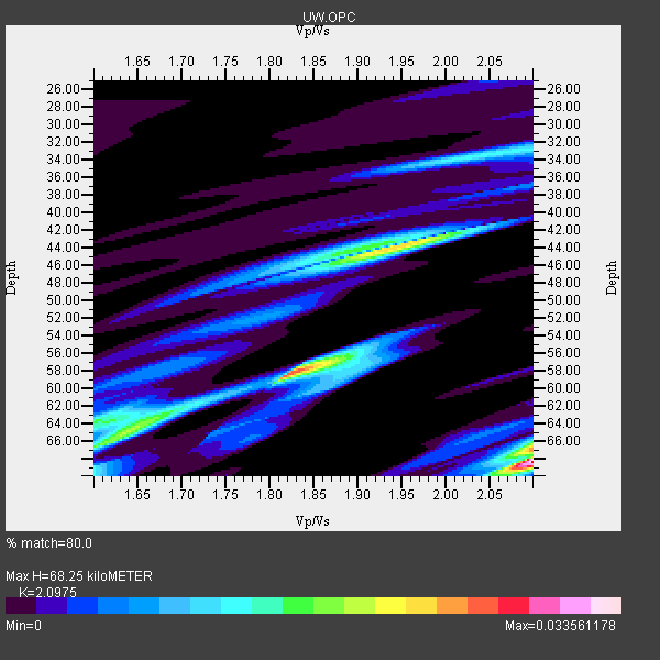
| Thickness Estimate: | 68 km |
| Thickness StdDev: | 7.1 km |
| Vp/Vs Estimate: | 2.10 |
| Vp/Vs StdDev: | 0.22 |
| Vs Estimate: | 3.13 km/s |
| Poisson's Ratio: | 0.35 |
| Peak Value: | 0.03 |
| Assumed Vp: | 6.566 km/s |
| Ps Weight: | 0.33333334 |
| PpPs Weight: | 0.33333334 |
| PsPs Weight: | 0.33333328 |
| Residual Complexity: | 0.930 |
| Nearby stations H: | +- |
| (2.0 deg) Vp/Vs: | +- |
0 with match > 90% ( 0.0 %) and 3 with match > 80% ( 16.666666 %) out of 18.
Download stack as xyz text file.
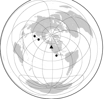
Azimuth Distribution of Events:
Prior Results for this Station
| Study | Thickness | Vp/Vs | Vp | Vs | Poissons Ratio | Extra |
| EARS | 68 km | 2.10 | 6.566 km/s | 3.13 km/s | 0.35 | |
| Crust2.0 | 34 km | 1.77 | 6.566 km/s | 3.707 km/s | 0.27 | L8,thin continental arc, Cordilleras, 0.5 km seds. |
| Global Maxima | 68 km | 2.10 | 6.566 km/s | 3.13 km/s | 0.35 | amp=0.033561178 |
| Local Maxima 1 | 58 km | 1.82 | 6.566 km/s | 3.608 km/s | 0.28 | amp=0.026746402 |
| Local Maxima 2 | 44 km | 1.95 | 6.566 km/s | 3.376 km/s | 0.32 | amp=0.023074122 |
| Local Maxima 3 | 67 km | 2.10 | 6.566 km/s | 3.13 km/s | 0.35 | amp=0.018128768 |
| Local Maxima 4 | 65 km | 1.64 | 6.566 km/s | 4.004 km/s | 0.20 | amp=0.017739052 |
| Predicted Arrivals for vertical incidence (zero ray parameter) | |
| Ps | 11.41 SECOND |
| PpPs | 32.20 SECOND |
| PsPs/PpSs | 43.60 SECOND |
Events Processed for this Station
Download zip of receiver functions as SAC
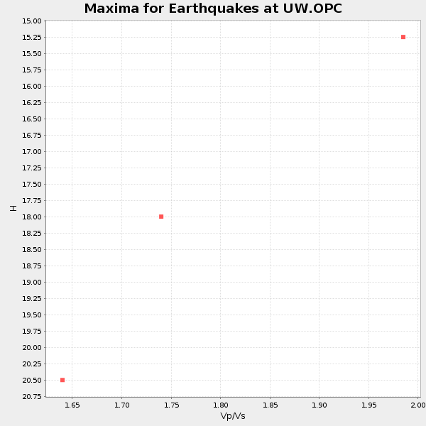
Plot maxima for each earthquake.
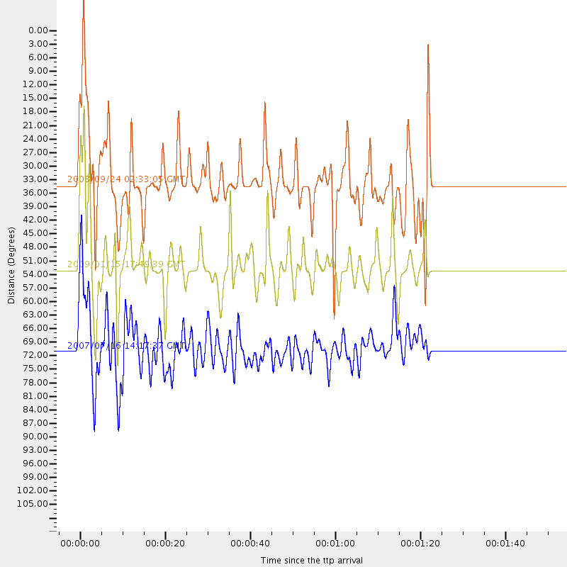
Events Used in the Stack
(3 events)| Radial Match | Distance | Baz | FERegion | Time | Lat/Lon | Depth | Magnitude |
| 87.22227 | 52.5 deg | 301.245 deg | East Of Kuril Islands | 2009/01/15 17:49:39 GMT | (46.9, 155.2) | 36 km | 6.9 MB, 7.5 MS, 7.4 MW, 7.4 MW |
| 81.41359 | 33.8 deg | 148.137 deg | Off Coast Of Jalisco, Mexico | 2008/09/24 02:33:05 GMT | (17.6, -105.5) | 10 km | 5.7 MB, 6.2 MS, 6.4 MW, 6.4 MW |
| 80.38446 | 70.5 deg | 303.548 deg | Sea Of Japan | 2007/07/16 14:17:37 GMT | (36.8, 134.9) | 350 km | 6.2 MB, 6.8 MW, 6.8 MW |
Losers
(15 events)| Radial Match | Distance | Baz | FERegion | Time | Lat/Lon | Depth | Magnitude | Reason |
| 94.14821 | 64.7 deg | 301.946 deg | Eastern Honshu, Japan | 2008/07/23 15:26:19 GMT | (39.8, 141.5) | 108 km | 6.6 MB, 6.8 MW, 6.8 MW | |
| 85.91899 | 33.2 deg | 145.106 deg | Near Coast Of Jalisco, Mexico | 2003/01/22 02:06:34 GMT | (18.8, -104.1) | 24 km | 6.5 MB, 7.6 MS, 7.6 MW, 7.4 MW | |
| 76.9375 | 49.2 deg | 309.726 deg | Sea Of Okhotsk | 2008/11/24 09:02:58 GMT | (54.2, 154.3) | 492 km | 6.5 MB, 7.3 MW, 7.3 MW | |
| 76.178314 | 50.5 deg | 305.618 deg | Kuril Islands | 2009/04/21 05:26:11 GMT | (50.8, 155.0) | 152 km | 6.0 MB, 6.2 MW, 6.2 MW | |
| 75.37699 | 34.3 deg | 297.015 deg | Andreanof Islands, Aleutian Is. | 2008/05/02 01:33:37 GMT | (51.9, -177.5) | 14 km | 6.3 MB, 6.8 MS, 6.6 MW, 6.6 MW | |
| 69.0955 | 43.9 deg | 130.514 deg | Near Coast Of Guatemala | 2008/04/15 03:03:04 GMT | (13.6, -90.6) | 33 km | 5.6 MB, 5.8 MS, 6.1 MW, 6.1 MW | |
| 66.80573 | 76.9 deg | 170.462 deg | Easter Island Region | 2008/08/19 10:58:00 GMT | (-28.5, -112.8) | 9.0 km | 5.5 MB, 5.3 MS, 5.7 MW, 5.7 MW | |
| 64.58882 | 82.6 deg | 233.116 deg | Fiji Islands Region | 2008/06/15 01:13:11 GMT | (-17.7, -179.7) | 611 km | 5.5 MB, 5.9 MW, 5.9 MW | |
| 64.17322 | 95.5 deg | 320.034 deg | Yunnan, China | 2008/08/31 08:31:10 GMT | (26.2, 102.0) | 10 km | 5.5 MB, 5.2 MS, 5.5 MW, 5.3 MW | |
| 63.25926 | 90.2 deg | 262.888 deg | New Britain Region, P.N.G. | 2008/06/19 00:36:45 GMT | (-4.9, 151.8) | 143 km | 5.5 MW, 5.2 MB, 5.4 MW | |
| 57.99062 | 68.1 deg | 309.549 deg | E. Russia-N.E. China Border Reg. | 2008/05/19 10:08:36 GMT | (42.5, 131.9) | 513 km | 5.7 MW, 5.4 MB, 5.6 MW | |
| 56.18787 | 87.8 deg | 329.796 deg | Qinghai, China | 2008/11/10 01:22:02 GMT | (37.6, 95.8) | 19 km | 6.4 MB, 6.4 MS, 6.3 MW, 6.3 MW | |
| 53.810738 | 76.6 deg | 283.58 deg | Mariana Islands | 2008/12/02 12:31:43 GMT | (19.1, 145.8) | 137 km | 5.9 MB, 5.9 MW, 5.9 MW | |
| 50.052837 | 74.2 deg | 293.943 deg | Bonin Islands, Japan Region | 2008/07/20 21:30:29 GMT | (27.8, 139.6) | 481 km | 5.8 MW, 5.1 MB, 5.8 MW | |
| 49.42998 | 88.4 deg | 320.502 deg | Sichuan, China | 2008/05/27 08:37:51 GMT | (32.7, 105.5) | 10 km | 5.5 MB, 5.2 MS, 5.7 MW, 5.5 MW |
