
Station UW OQNOB - Black Knob, Quinault Indian Nation, WA, USA
Network: UW - Pacific Northwest Regional Seismic Network
Nearby stations (2 deg radius)

| Station | Name | (Lat, Lon) | Start / End | Elevation |
| OQNOB | Black Knob, Quinault Indian Nation, WA, USA | (47.41, -124.10) | 2023-09-14 / 2499-01-01 | 208 m |
| Crust2 Type: | C3,continental shelf, 2 km seds. |
| Thickness Estimate: | 28 km |
| Thickness StdDev: | 3.3 km |
| Vp/Vs Estimate: | 1.68 |
| Vp/Vs StdDev: | 0.09 |
| Vs Estimate: | 3.657 km/s |
| Poisson's Ratio: | 0.22 |
| Peak Value: | 0.03 |
| Assumed Vp: | 6.134 km/s |
| Ps Weight: | 0.33333334 |
| PpPs Weight: | 0.33333334 |
| PsPs Weight: | 0.33333328 |
| Residual Complexity: | 0.631 |
| Nearby stations H: | +- |
| (2.0 deg) Vp/Vs: | +- |
2 with match > 90% ( 3.7735848 %) and 8 with match > 80% ( 15.094339 %) out of 53.
Download stack as xyz text file.
Azimuth Distribution of Events:

Prior Results for this Station
| Study | Thickness | Vp/Vs | Vp | Vs | Poissons Ratio | Extra |
| EARS | 28 km | 1.68 | 6.134 km/s | 3.657 km/s | 0.22 | |
| Crust2.0 | 31 km | 1.80 | 6.134 km/s | 3.406 km/s | 0.28 | C3,continental shelf, 2 km seds. |
| Global Maxima | 28 km | 1.68 | 6.134 km/s | 3.657 km/s | 0.22 | amp=0.029645838 |
| Local Maxima 1 | 26 km | 1.60 | 6.134 km/s | 3.828 km/s | 0.18 | amp=0.024211835 |
| Local Maxima 2 | 27 km | 1.84 | 6.134 km/s | 3.334 km/s | 0.29 | amp=0.020130198 |
| Local Maxima 3 | 37 km | 1.63 | 6.134 km/s | 3.769 km/s | 0.20 | amp=0.017156687 |
| Local Maxima 4 | 65 km | 1.63 | 6.134 km/s | 3.763 km/s | 0.20 | amp=0.0132967215 |
| Predicted Arrivals for vertical incidence (zero ray parameter) | |
| Ps | 3.04 SECOND |
| PpPs | 12.00 SECOND |
| PsPs/PpSs | 15.04 SECOND |
Events Processed for this Station
Download zip of receiver functions as SAC
Plot maxima for each earthquake.
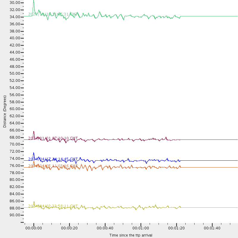
Events Used in the Stack
(8 events)| Radial Match | Distance | Baz | FERegion | Time | Lat/Lon | Depth | Magnitude |
| 92.49312 | 87.8 deg | 303.377 deg | Taiwan | 2024/04/02 23:58:11 UTC | (23.8, 121.6) | 35 km | 7.4 mww |
| 90.06128 | 77.0 deg | 131.154 deg | Near Coast Of Peru | 2024/06/28 05:36:37 UTC | (-15.8, -74.4) | 28 km | 7.2 mww |
| 88.10701 | 68.7 deg | 302.454 deg | Near West Coast Of Honshu, Japan | 2024/01/01 07:10:10 UTC | (37.5, 137.2) | 0.0 km | 7.4 Mi |
| 86.59928 | 62.9 deg | 104.206 deg | Near Coast Of Venezuela | 2024/06/23 03:58:00 UTC | (10.8, -62.6) | 87 km | 6.0 mww |
| 85.7143 | 80.6 deg | 227.834 deg | Tonga Islands | 2024/05/26 20:47:09 UTC | (-19.4, -174.9) | 112 km | 6.6 mww |
| 82.392624 | 74.5 deg | 302.199 deg | Shikoku, Japan | 2024/04/17 14:14:45 UTC | (33.2, 132.4) | 26 km | 6.3 mww |
| 81.80745 | 76.5 deg | 283.507 deg | Mariana Islands | 2024/04/05 11:03:16 UTC | (19.1, 145.4) | 222 km | 6.8 mww |
| 80.43209 | 33.7 deg | 298.551 deg | Andreanof Islands, Aleutian Is. | 2023/10/16 11:35:31 UTC | (52.4, -176.9) | 187 km | 6.4 Mww |
Losers
(45 events)| Radial Match | Distance | Baz | FERegion | Time | Lat/Lon | Depth | Magnitude | Reason |
| 90.52143 | 89.3 deg | 342.979 deg | Kyrgyzstan-Xinjiang Border Reg. | 2024/01/22 18:42:33 UTC | (41.3, 78.8) | 10 km | 5.5 mb | |
| 77.40804 | 42.1 deg | 130.566 deg | Near Coast Of Chiapas, Mexico | 2024/05/12 11:39:14 UTC | (14.5, -92.4) | 75 km | 6.4 mww | |
| 76.79409 | 93.9 deg | 266.044 deg | Eastern New Guinea Reg., P.N.G. | 2023/10/07 08:34:26 UTC | (-5.6, 146.1) | 53 km | 6.7 mww | |
| 76.22252 | 96.5 deg | 289.858 deg | Mindanao, Philippines | 2023/12/02 15:31:27 UTC | (8.5, 126.8) | 48 km | 5.5 mb | |
| 76.20976 | 89.4 deg | 343.049 deg | Kyrgyzstan-Xinjiang Border Reg. | 2024/01/22 18:09:04 UTC | (41.3, 78.6) | 13 km | 7.0 Mww | |
| 75.218735 | 87.7 deg | 303.44 deg | Taiwan | 2024/04/03 00:43:55 UTC | (24.0, 121.6) | 10 km | 5.5 mb | |
| 75.04802 | 43.1 deg | 308.953 deg | Komandorskiye Ostrova Region | 2023/10/26 16:05:11 UTC | (56.1, 164.7) | 2.4 km | 5.9 Mww | |
| 73.43479 | 38.6 deg | 131.683 deg | Chiapas, Mexico | 2023/10/07 05:06:55 UTC | (17.1, -95.0) | 108 km | 5.9 mww | |
| 73.006516 | 70.5 deg | 294.338 deg | Southeast Of Honshu, Japan | 2023/10/04 05:57:17 UTC | (30.8, 142.0) | 10 km | 5.6 mww | |
| 72.76422 | 30.1 deg | 296.65 deg | Fox Islands, Aleutian Islands | 2024/05/19 09:35:24 UTC | (52.2, -170.9) | 28 km | 6.0 mww | |
| 72.60533 | 63.2 deg | 74.319 deg | Northern Mid-Atlantic Ridge | 2024/03/14 21:10:25 UTC | (29.8, -42.7) | 10 km | 6.0 mww | |
| 70.52118 | 87.3 deg | 243.603 deg | Vanuatu Islands | 2023/09/28 14:40:26 UTC | (-15.6, 167.7) | 126 km | 6.0 mww | |
| 68.51885 | 89.6 deg | 224.243 deg | Kermadec Islands Region | 2024/05/31 15:54:41 UTC | (-29.0, -176.9) | 20 km | 6.2 mww | |
| 68.10864 | 80.4 deg | 228.301 deg | Tonga Islands | 2024/01/18 22:12:20 UTC | (-18.9, -175.1) | 218 km | 6.4 Mww | |
| 67.5613 | 90.4 deg | 133.722 deg | La Rioja Province, Argentina | 2024/01/03 08:04:01 UTC | (-28.5, -68.9) | 155 km | 5.5 mww | |
| 66.532555 | 80.3 deg | 228.71 deg | Tonga Islands | 2023/12/11 06:33:31 UTC | (-18.7, -175.5) | 238 km | 6.1 Mww | |
| 65.10839 | 89.3 deg | 135.814 deg | Near Coast Of Central Chile | 2023/10/31 12:33:44 UTC | (-28.7, -71.6) | 41 km | 6.7 mww | |
| 64.6635 | 89.6 deg | 240.416 deg | Vanuatu Islands | 2023/10/29 04:32:08 UTC | (-19.4, 168.8) | 80 km | 6.0 mww | |
| 62.294273 | 90.3 deg | 239.323 deg | Vanuatu Islands | 2023/12/07 12:56:30 UTC | (-20.7, 169.2) | 48 km | 7.1 Mww | |
| 61.982323 | 94.1 deg | 266.186 deg | Eastern New Guinea Reg., P.N.G. | 2023/10/07 14:13:36 UTC | (-5.6, 145.9) | 62 km | 5.5 mb | |
| 61.696487 | 81.2 deg | 232.18 deg | Fiji Islands Region | 2023/10/31 11:10:56 UTC | (-17.5, -179.0) | 548 km | 6.4 mww | |
| 61.435505 | 77.1 deg | 131.292 deg | Near Coast Of Peru | 2024/06/16 14:47:31 UTC | (-15.9, -74.5) | 20 km | 6.0 mww | |
| 61.228287 | 65.9 deg | 126.361 deg | Northern Peru | 2024/06/18 02:22:09 UTC | (-3.9, -76.7) | 100 km | 5.5 Mww | |
| 60.97069 | 68.2 deg | 302.442 deg | Near West Coast Of Honshu, Japan | 2024/01/09 08:59:10 UTC | (37.9, 137.7) | 11 km | 5.8 Mww | |
| 58.955677 | 77.6 deg | 300.044 deg | Southeast Of Ryukyu Islands | 2024/04/15 22:38:57 UTC | (29.5, 131.7) | 8.0 km | 5.9 mww | |
| 57.81801 | 64.3 deg | 301.971 deg | Near East Coast Of Honshu, Japan | 2024/04/01 19:24:36 UTC | (40.1, 141.7) | 73 km | 5.9 mww | |
| 57.73737 | 89.8 deg | 262.078 deg | New Britain Region, P.N.G. | 2024/04/15 10:43:27 UTC | (-5.2, 151.9) | 52 km | 5.4 Mww | |
| 57.538292 | 89.0 deg | 242.079 deg | Vanuatu Islands | 2024/01/23 14:33:47 UTC | (-17.9, 167.8) | 10 km | 6.5 Mi | |
| 56.52911 | 77.7 deg | 228.512 deg | Tonga Islands | 2024/06/18 06:40:36 UTC | (-16.5, -173.8) | 35 km | 5.9 mww | |
| 55.736763 | 74.1 deg | 293.732 deg | Bonin Islands, Japan Region | 2024/04/27 08:35:34 UTC | (27.8, 139.6) | 503 km | 6.5 mww | |
| 55.49532 | 68.7 deg | 302.398 deg | Near West Coast Of Honshu, Japan | 2024/06/02 21:31:38 UTC | (37.5, 137.2) | 4.8 km | 5.8 mww | |
| 55.19604 | 82.6 deg | 280.135 deg | South Of Mariana Islands | 2024/02/04 09:50:42 UTC | (12.4, 143.5) | 10 km | 5.7 Mi | |
| 54.6097 | 36.6 deg | 299.235 deg | Rat Islands, Aleutian Islands | 2024/03/30 16:28:57 UTC | (52.1, 178.4) | 115 km | 5.8 mww | |
| 52.731987 | 88.4 deg | 156.893 deg | West Chile Rise | 2024/06/04 18:32:59 UTC | (-37.3, -94.6) | 10 km | 5.5 Mww | |
| 52.514717 | 43.4 deg | 128.618 deg | Guatemala | 2024/01/27 05:52:49 UTC | (14.1, -90.5) | 108 km | 6.1 Mww | |
| 52.48957 | 92.5 deg | 225.313 deg | Kermadec Islands Region | 2023/11/13 14:40:55 UTC | (-30.7, -179.7) | 435 km | 5.7 Mww | |
| 52.26951 | 84.9 deg | 246.13 deg | Santa Cruz Islands | 2024/05/21 09:50:43 UTC | (-12.1, 167.3) | 248 km | 5.4 Mww | |
| 51.35347 | 88.4 deg | 242.512 deg | Vanuatu Islands | 2024/05/25 22:23:16 UTC | (-17.1, 167.9) | 29 km | 6.3 mww | |
| 50.612286 | 94.4 deg | 223.5 deg | South Of Kermadec Islands | 2024/06/27 16:37:51 UTC | (-33.4, -179.2) | 32 km | 5.9 Mww | |
| 50.03454 | 38.2 deg | 232.97 deg | Hawaii | 2024/02/09 20:06:30 UTC | (19.0, -155.5) | 10 km | 6.3 Mi | |
| 49.214256 | 35.7 deg | 135.436 deg | Central Mexico | 2023/12/07 20:03:38 UTC | (18.4, -98.6) | 44 km | 5.8 mww | |
| 47.92746 | 72.1 deg | 298.314 deg | Southeast Of Honshu, Japan | 2024/05/29 17:14:58 UTC | (32.3, 137.6) | 392 km | 5.5 Mww | |
| 36.550728 | 86.9 deg | 282.735 deg | W. Caroline Islands, Micronesia | 2024/02/14 11:40:21 UTC | (11.0, 138.6) | 10 km | 6.0 mww | |
| 36.26105 | 48.4 deg | 110.386 deg | Jamaica Region | 2023/10/30 15:57:20 UTC | (18.2, -76.6) | 10 km | 5.4 mww | |
| 28.297688 | 78.5 deg | 227.897 deg | Tonga Islands | 2023/10/27 03:02:24 UTC | (-17.6, -173.8) | 35 km | 5.6 mb |

