
Station X4 MA09 - Snohomish County, WA, USA
Network: X416 - Monitoring Active Faults for Tectonic Mapping Efforts in Washington State
Nearby stations (2 deg radius)
| Station | Name | (Lat, Lon) | Start / End | Elevation |
| MA09 | Snohomish County, WA, USA | (47.93, -121.93) | 2016-06-27 / 2016-09-26 | -1.0 m |
| Crust2 Type: | L3,continental arc, Southern Andes, 0.2 km seds. |
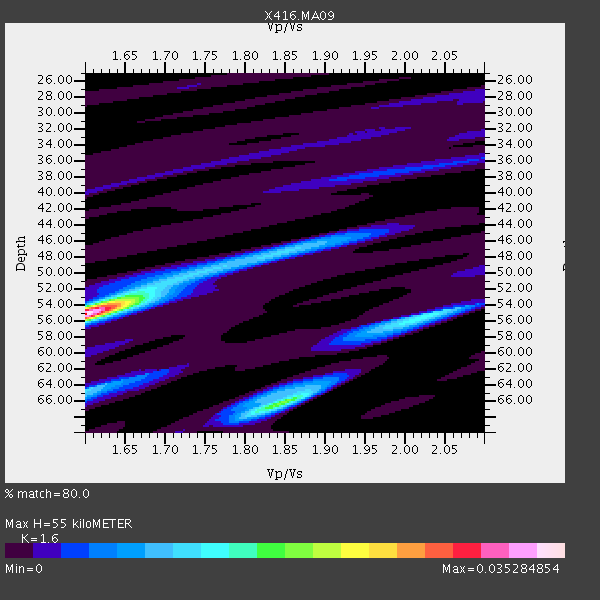
| Thickness Estimate: | 55 km |
| Thickness StdDev: | 4.5 km |
| Vp/Vs Estimate: | 1.60 |
| Vp/Vs StdDev: | 0.14 |
| Vs Estimate: | 4.123 km/s |
| Poisson's Ratio: | 0.18 |
| Peak Value: | 0.04 |
| Assumed Vp: | 6.597 km/s |
| Ps Weight: | 0.33333334 |
| PpPs Weight: | 0.33333334 |
| PsPs Weight: | 0.33333328 |
| Residual Complexity: | 0.677 |
| Nearby stations H: | +- |
| (2.0 deg) Vp/Vs: | +- |
0 with match > 90% ( 0.0 %) and 4 with match > 80% ( 10.256411 %) out of 39.
Download stack as xyz text file.
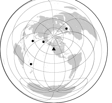
Azimuth Distribution of Events:
Prior Results for this Station
| Study | Thickness | Vp/Vs | Vp | Vs | Poissons Ratio | Extra |
| EARS | 55 km | 1.60 | 6.597 km/s | 4.123 km/s | 0.18 | |
| Crust2.0 | 40 km | 1.77 | 6.597 km/s | 3.723 km/s | 0.27 | L3,continental arc, Southern Andes, 0.2 km seds. |
| Global Maxima | 55 km | 1.60 | 6.597 km/s | 4.123 km/s | 0.18 | amp=0.035284854 |
| Local Maxima 1 | 66 km | 1.85 | 6.597 km/s | 3.571 km/s | 0.29 | amp=0.018513104 |
| Local Maxima 2 | 55 km | 2.03 | 6.597 km/s | 3.254 km/s | 0.34 | amp=0.011596764 |
| Local Maxima 3 | 64 km | 1.60 | 6.597 km/s | 4.117 km/s | 0.18 | amp=0.010859669 |
| Local Maxima 4 | 50 km | 1.74 | 6.597 km/s | 3.792 km/s | 0.25 | amp=0.0095117465 |
| Predicted Arrivals for vertical incidence (zero ray parameter) | |
| Ps | 5.00 SECOND |
| PpPs | 21.67 SECOND |
| PsPs/PpSs | 26.68 SECOND |
Events Processed for this Station
Download zip of receiver functions as SAC
Plot maxima for each earthquake.
Events Used in the Stack
(4 events)| Radial Match | Distance | Baz | FERegion | Time | Lat/Lon | Depth | Magnitude |
| 86.34998 | 91.0 deg | 236.93 deg | Southeast Of Loyalty Islands | 2016/08/12 01:26:35 GMT | (-22.5, 173.1) | 10 km | 7.2 MWW, 7.6 MI |
| 83.6764 | 42.4 deg | 305.65 deg | Komandorskiye Ostrova Region | 2016/09/05 22:54:04 GMT | (54.3, 168.6) | 10 km | 5.7 MB |
| 81.879776 | 75.8 deg | 291.359 deg | Volcano Islands, Japan Region | 2016/08/04 16:24:33 GMT | (24.9, 142.0) | 510 km | 6.3 MWW, 6.2 MWC, 6.3 MWB, 6.3 MWC |
| 80.09477 | 81.4 deg | 31.741 deg | Central Italy | 2016/08/24 01:36:33 GMT | (42.7, 13.2) | 10 km | 6.2 MWP |
Losers
(35 events)| Radial Match | Distance | Baz | FERegion | Time | Lat/Lon | Depth | Magnitude | Reason |
| 96.124985 | 78.2 deg | 284.399 deg | Mariana Islands | 2016/07/29 21:18:25 GMT | (18.5, 145.5) | 212 km | 7.7 MWW, 7.7 MWB, 7.7 MI | |
| 81.10497 | 69.1 deg | 298.541 deg | Off East Coast Of Honshu, Japan | 2016/09/23 00:14:33 GMT | (34.5, 141.7) | 10 km | 6.4 MWP, 6.3 MWW | |
| 78.99898 | 36.3 deg | 148.98 deg | Off Coast Of Guerrero, Mexico | 2016/07/23 08:52:02 GMT | (14.9, -103.5) | 45 km | 5.5 MB | |
| 74.78625 | 64.0 deg | 301.957 deg | Off East Coast Of Honshu, Japan | 2016/08/20 15:58:04 GMT | (40.3, 143.8) | 10 km | 6.0 MO | |
| 73.54262 | 84.2 deg | 231.959 deg | Fiji Islands Region | 2016/09/24 21:28:42 GMT | (-19.8, -178.3) | 594 km | 6.8 MO | |
| 71.987305 | 86.9 deg | 135.362 deg | Near Coast Of Northern Chile | 2016/07/25 17:26:49 GMT | (-26.1, -70.6) | 68 km | 6.2 MB | |
| 71.887764 | 89.5 deg | 264.042 deg | New Ireland Region, P.N.G. | 2016/08/31 03:11:36 GMT | (-3.7, 152.8) | 499 km | 6.7 MO | |
| 71.56409 | 90.6 deg | 242.146 deg | Vanuatu Islands | 2016/07/20 15:13:16 GMT | (-18.9, 169.0) | 164 km | 6.0 MO | |
| 71.365845 | 66.3 deg | 129.804 deg | Northern Peru | 2016/09/10 10:08:20 GMT | (-5.6, -77.0) | 114 km | 6.0 MB | |
| 69.97563 | 81.9 deg | 302.238 deg | Ryukyu Islands, Japan | 2016/09/26 05:19:58 GMT | (27.5, 128.6) | 40 km | 6.0 MB | |
| 69.870926 | 59.7 deg | 128.82 deg | Near Coast Of Ecuador | 2016/07/11 02:11:04 GMT | (0.6, -79.7) | 19 km | 6.3 MWW, 6.3 MWC, 6.3 MWB | |
| 69.22554 | 64.0 deg | 302.051 deg | Off East Coast Of Honshu, Japan | 2016/08/20 09:01:26 GMT | (40.4, 143.7) | 10 km | 6.0 MO | |
| 68.790474 | 75.3 deg | 307.286 deg | South Korea | 2016/09/12 11:32:55 GMT | (35.8, 129.2) | 13 km | 5.4 Mww | |
| 68.423775 | 90.0 deg | 225.992 deg | Kermadec Islands Region | 2016/07/13 12:11:13 GMT | (-28.0, -176.4) | 12 km | 6.3 MWB | |
| 67.91575 | 57.5 deg | 306.829 deg | Northwest Of Kuril Islands | 2016/07/23 01:00:21 GMT | (47.7, 147.0) | 407 km | 5.7 MB | |
| 67.08043 | 37.1 deg | 298.056 deg | Rat Islands, Aleutian Islands | 2016/08/14 16:28:55 GMT | (51.5, 179.6) | 65 km | 5.6 MWB, 5.5 MI, 5.6 ML | |
| 64.924644 | 56.0 deg | 120.927 deg | Northern Colombia | 2016/09/14 01:58:30 GMT | (7.3, -76.1) | 10 km | 5.9 MWP | |
| 63.90016 | 77.8 deg | 230.845 deg | Tonga Islands | 2016/07/23 20:09:19 GMT | (-15.1, -173.6) | 10 km | 5.7 MB | |
| 62.340584 | 96.6 deg | 274.146 deg | Near North Coast Of Irian Jaya | 2016/09/17 01:20:18 GMT | (-2.1, 140.6) | 10 km | 5.9 MWP | |
| 61.861477 | 71.7 deg | 295.355 deg | Southeast Of Honshu, Japan | 2016/09/20 16:21:16 GMT | (30.5, 142.1) | 10 km | 6.1 MWW, 6.0 MWB | |
| 57.751793 | 37.0 deg | 139.433 deg | Oaxaca, Mexico | 2016/06/27 20:50:34 GMT | (16.6, -97.8) | 19 km | 5.7 MWW, 5.5 MWB | |
| 57.15476 | 90.2 deg | 226.052 deg | Kermadec Islands Region | 2016/07/13 12:18:33 GMT | (-28.1, -176.6) | 10 km | 5.7 MB | |
| 52.334057 | 90.1 deg | 225.84 deg | Kermadec Islands Region | 2016/07/13 11:56:58 GMT | (-28.2, -176.3) | 17 km | 5.7 MB | |
| 52.151955 | 98.3 deg | 292.176 deg | Mindanao, Philippines | 2016/09/04 02:38:12 GMT | (8.4, 125.9) | 12 km | 5.9 MWP | |
| 47.087692 | 92.2 deg | 268.098 deg | Admiralty Islands Region, P.N.G. | 2016/07/25 19:38:44 GMT | (-2.9, 148.0) | 6.5 km | 6.3 MO | |
| 45.011513 | 81.6 deg | 228.4 deg | Tonga Islands | 2016/09/02 11:23:07 GMT | (-19.6, -173.6) | 10 km | 5.5 MB | |
| 43.60839 | 86.1 deg | 129.776 deg | Jujuy Province, Argentina | 2016/08/04 14:15:11 GMT | (-22.4, -66.0) | 258 km | 6.0 MO | |
| 42.61926 | 89.6 deg | 255.576 deg | Solomon Islands | 2016/09/14 07:24:59 GMT | (-9.4, 159.1) | 10 km | 6.0 MWB | |
| 39.93244 | 59.7 deg | 128.791 deg | Near Coast Of Ecuador | 2016/07/11 02:01:09 GMT | (0.6, -79.6) | 14 km | 5.8 MWW, 5.7 MWB, 5.9 MWC | |
| 39.739918 | 58.3 deg | 311.577 deg | Sakhalin, Russia | 2016/08/14 11:15:14 GMT | (50.4, 142.3) | 5.8 km | 5.7 MWW, 5.7 MWB, 5.8 MWC | |
| 37.196686 | 89.4 deg | 245.098 deg | Vanuatu Islands | 2016/06/30 11:30:34 GMT | (-16.1, 167.4) | 40 km | 5.8 MB | |
| 35.885746 | 86.8 deg | 250.4 deg | Santa Cruz Islands Region | 2016/07/04 09:25:41 GMT | (-10.6, 165.0) | 67 km | 5.6 MB | |
| 35.52881 | 74.2 deg | 298.152 deg | Southeast Of Honshu, Japan | 2016/08/25 17:04:43 GMT | (30.6, 137.8) | 456 km | 5.9 MWW, 5.9 MWB | |
| 35.500614 | 88.8 deg | 246.708 deg | Vanuatu Islands | 2016/06/28 22:46:46 GMT | (-14.6, 166.5) | 10 km | 5.5 MB | |
| 19.254658 | 74.0 deg | 296.801 deg | Southeast Of Honshu, Japan | 2016/08/22 09:33:08 GMT | (29.9, 139.1) | 404 km | 5.6 MB |

